R.R.O. 1990, Reg. 608: RESTRICTED USE OF LEFT LANES BY COMMERCIAL MOTOR VEHICLES, Highway Traffic Act, R.S.O. 1990, c. H.8
Highway Traffic Act
Code de la route
R.R.O. 1990, REGULATION 608
RESTRICTED USE OF LEFT LANES BY COMMERCIAL MOTOR VEHICLES
Historical version for the period December 1, 2005 to February 27, 2008.
Last amendment: O. Reg. 619/05.
This Regulation is made in English only.
1. (1) Subject to subsection (2), no person shall operate a commercial motor vehicle or any combination of a commercial motor vehicle and a towed vehicle that exceeds 6.5 metres in length, except a bus, an ambulance or a fire apparatus, in the left lane or, where the left lane has been designated as a high occupancy vehicle lane, in the lane adjacent to the high occupancy vehicle lane of those portions of the King’s Highway described in the Schedules. R.R.O. 1990, Reg. 608, s. 1 (1); O. Reg. 619/05, s. 1 (1).
(2) Subsection (1) does not apply to a commercial motor vehicle engaged in maintenance or construction or where an emergency requires the use of the lane by a commercial motor vehicle. R.R.O. 1990, Reg. 608, s. 1 (2); O. Reg. 619/05, s. 1 (2).
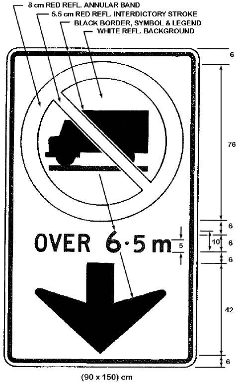
2. (1) A sign indicating that commercial motor vehicles are prohibited in a lane of a highway shall be in the form and dimensions prescribed and illustrated in the following Figure:

R.R.O. 1990, Reg. 608, s. 2 (1); O. Reg. 619/05, s. 2 (1).
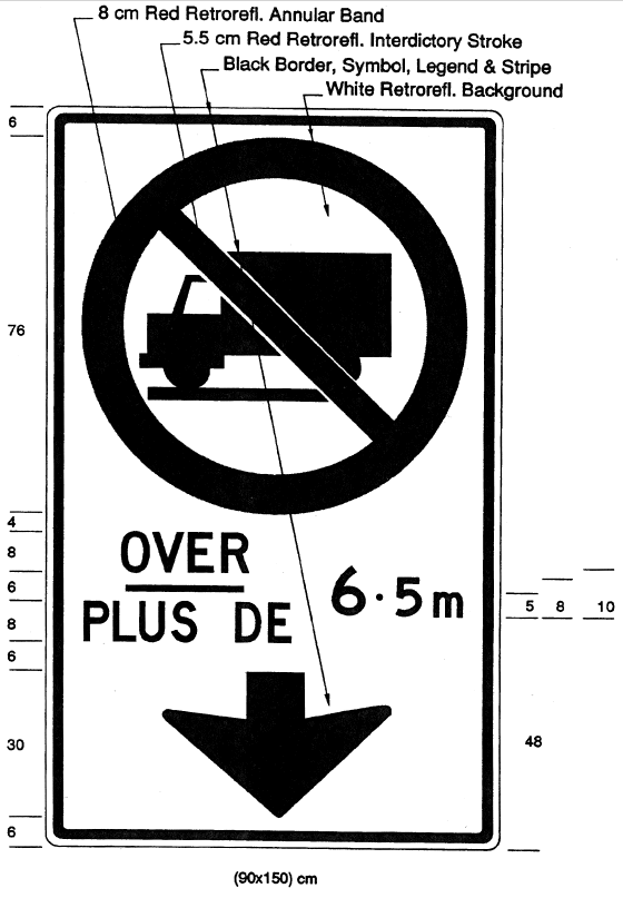
(1.1) Despite subsection (1), in an area designated under the French Language Services Act, a sign indicating that commercial motor vehicles are prohibited in a lane of a highway shall be in the form and dimensions prescribed and illustrated in the following Figure:

O. Reg. 442/93, s. 1 (1); O. Reg. 619/05, s. 2 (2).
(2) The sign referred to in subsection (1) or (1.1) shall be erected directly above the lane on those portions of the King’s Highway described in the Schedules. O. Reg. 442/93, s. 1 (2); O. Reg. 619/05, s. 2 (3).
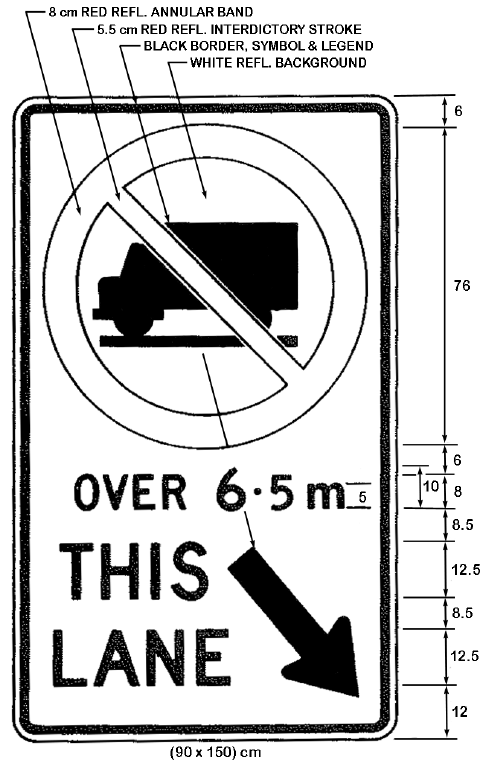
3. (1) Where the conditions make it impracticable to place a sign in accordance with the requirements of section 2, a sign indicating that commercial motor vehicles are prohibited in a lane of a highway shall be in the form and dimensions illustrated in the following Figure:

R.R.O. 1990, Reg. 608, s. 3 (1); O. Reg. 619/05, s. 3 (1).
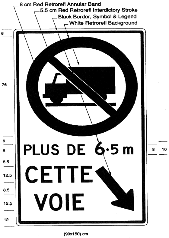
(1.1) Despite subsection (1), in an area designated under the French Language Services Act, where the conditions make it impracticable to place a sign in accordance with the requirements of section 2, a sign indicating that commercial motor vehicles are prohibited in a lane of a highway shall be in the form and dimensions illustrated in the following Figure:

O. Reg. 442/93, s. 2; O. Reg. 619/05, s. 3 (2).
(2) The sign referred to in subsection (1) shall be erected not less than 1.5 metres or more than 2.5 metres above the level of the King’s Highway described in the Schedules. R.R.O. 1990, Reg. 608, s. 3 (2).
(3) The sign referred to in subsection (1.1) shall be erected not less than 1.5 metres or more than 2.5 metres above the level of the King’s Highway described in the Schedules and shall be erected in combination with the sign required by subsection (1), below it, to the right of it or up to 100 metres beyond it. O. Reg. 442/93, s. 2.
SCHEDULE 1
HIGHWAY NO. 400
1. That part of the King’s Highway known as No. 400 lying between a point situate at its intersection with the King’s Highway known as No. 401 in the City of Toronto and a point situate at its intersection with the King’s Highway known as No. 11 in the Township of Springwater in the County of Simcoe.
O. Reg. 523/00, s. 1.
SCHEDULE 2
HIGHWAY NO. 401
1. That part of the King's Highway known as No. 401 lying between a point situate at its intersection with the centre line of the King’s Highway known as Nos. 35 and 115 in the Municipality of Clarington in The Regional Municipality of Durham and a point situate at its intersection with the centre line of the King’s Highway known as No. 8 in the City of Cambridge in The Regional Municipality of Waterloo.
2. That part of the King’s Highway known as No. 401 lying between a point situate at its intersection with the centre line of the King’s Highway known as No. 403 in the City of Woodstock in the County of Oxford and a point situate at its intersection with the centre line of the roadway known as Wellington Road in the City of London in the County of Middlesex.
O. Reg. 523/00, s. 1.
SCHEDULE 3
HIGHWAY NO. 403
1. That part of the King’s Highway known as No. 403 in The Regional Municipality of Peel lying between a point situate at its intersection with the King’s Highway known as the Queen Elizabeth Way in the Town of Oakville and a point situate at its intersection with the King’s Highway known as No. 401 in the City of Mississauga.
2. That part of the King’s Highway known as No. 403 (westbound) lying between a point situate at its intersection with the centre line of the underpass structure of the roadway known as King Road in the City of Burlington in The Regional Municipality of Halton and a point situate at its intersection with the centre line of the underpass structure of the roadway known as Golf Links in the Town of Ancaster in The Regional Municipality of Hamilton-Wentworth.
3. That part of the King’s Highway known as No. 403 (eastbound) in the City of Burlington in The Regional Municipality of Halton lying between a point situate at its intersection with the centre line of the underpass structure of the roadway known as Lemonville Road and a point situate at its intersection with the centre line of the underpass structure of the roadway known as King Road.
O. Reg. 523/00, s. 1.
SCHEDULE 4
HIGHWAY NO. 404
1. That part of the King’s Highway known as No. 404 (southbound) lying between a point situate at its intersection with the King’s Highway known as No. 401 in the City of Toronto and a point situate 1400 metres measured southerly from its intersection with the roadway known as Aurora Road in the Town of Aurora.
2. That part of the King’s Highway known as No. 404 (northbound) lying between a point situate at its intersection with the roadway known as Van Horne Avenue in the City of Toronto and a point situate 1400 metres measured southerly from it intersection with the roadway known as Aurora Road in the Town of Aurora.
O. Reg. 523/00, s. 1; O. Reg. 370/04, s. 1.
SCHEDULE 5
HIGHWAY NO. 407
1. That part of the King’s Highway known as No. 407 lying between a point situate at its intersection with the King’s Highway known as 410 in the City of Brampton in The Regional Municipality of Peel and a point situate at its intersection with the roadway known as Markham Road (King’s Highway No. 48) in the Town of Markham in The Regional Municipality of York.
O. Reg. 523/00, s. 1.
SCHEDULE 6
HIGHWAY NO. 409
1. That part of the King’s Highway known as No. 409 in the City of Toronto lying between a point situate at its intersection with the King’s Highway known as No. 401 and a point situate at its intersection with the roadway known as Carlingview Drive.
O. Reg. 523/00, s. 1.
SCHEDULE 7
HIGHWAY NO. 410
![]()
1. That part of the King’s Highway known as No. 410 in The Regional Municipality of Peel lying between a point situate at its intersection with the King’s Highway known as No. 401 in the City of Mississauga and a point situate at its intersection with the roadway known as Bovaird Drive in the City of Brampton.
O. Reg. 523/00, s. 1.
SCHEDULE 8
HIGHWAY NO. 417
1. That part of the King’s Highway known as No. 417 (westbound) in the City of Ottawa in The Regional Municipality of Ottawa-Carleton lying between a point situate at its intersection with the roadway known as Regional Municipality of Ottawa-Carleton Road 174 (old Highway 17) and a point situate at its intersection with the roadway known as Woodroffe Avenue.
2. That part of the King’s Highway known as No. 417 (eastbound) in The Regional Municipality of Ottawa-Carleton lying between a point situate at its intersection with the roadway known as Moodie Drive in the City of Nepean and a point situate at its intersection with the roadway known as St. Laurent Boulevard in the City of Ottawa.
O. Reg. 523/00, s. 1.
SCHEDULE 9
HIGHWAY NO. 427
1. That part of the King’s Highway known as No. 427 (northbound) in the City of Toronto lying between a point situate at its intersection with the King’s Highway known as the Queen Elizabeth Way and a point situate at its intersection with the mid-point of the overpass structure at Disco Road.
2. That part of the King’s Highway known as No. 427 (southbound) in the City of Toronto lying between a point situate at its intersection with the roadway known as Finch Avenue and a point situate at its intersection with the roadway known as Airport Road.
3. That part of the King’s Highway known as No. 427 (southbound) in the City of Toronto lying between a point situate at its intersection with the King’s Highway known as No. 401 and a point situate at its intersection with the King’s Highway known as Queen Elizabeth Way.
O. Reg. 523/00, s. 1.
SCHEDULE 10
QUEEN ELIZABETH WAY
1. That part of the King’s Highway known as the Queen Elizabeth Way lying between a point situate 25 metres measured westerly from its intersection with the mid-point of the underpass structure of the roadway known as The East Mall in the City of Toronto and a point situate at its intersection with the roadway known as Guelph Line in the City of Burlington in The Regional Municipality of Halton.
2. That part of the King’s Highway known as the Queen Elizabeth Way lying between a point situate 500 metres measured northerly from its intersection with the northerly limit of the King’s Highway known as No. 2 in the City of Burlington in The Regional Municipality of Halton and a point situate 1 kilometre measured westerly from its intersection with the mid-point of the overpass structure of the King’s Highway known as No. 406 in the City of St. Catharines in The Regional Municipality of Niagara.
3. That part of the King’s Highway known as the Queen Elizabeth Way in the City of St. Catharines in The Regional Municipality of Niagara beginning at a point situate at the westerly limit of the structure over Regional Road 52 (Bunting Road) and extending easterly for a distance of 2160 metres.
O. Reg. 523/00, s. 1.