R.R.O. 1990, Reg. 992: CANADA LANDS, Registry Act, R.S.O. 1990, c. R.20
Registry Act
Loi sur l’enregistrement des actes
R.R.O. 1990, REGULATION 992
CANADA LANDS
Note: This Regulation was revoked on September 1, 2011. See: O. Reg. 438/11, ss. 1, 2.
Last amendment: O. Reg. 438/11.
This Regulation is made in English only.
1. For the purposes of,
(a) filing plans of public lands under the Canada Lands Surveys Act;
(b) depositing plans and descriptions of land under the Navigable Waters Protection Act (Canada);
(c) registering,
(i) orders of the Governor in Council that transfer jurisdiction and control of land from the Government of Canada to the Government of Ontario, and
(ii) plans under the Public Transportation and Highway Improvement Act of land to which subclause (i) applies; and
(d) registering instruments that affect lands that were heretofore or are hereafter granted, in fee simple, by Canada,
the lands that comprise the national parks and Indian reserves set forth in Column 2 of the Schedule are annexed to the respective registry divisions set opposite thereto in Column 1. R.R.O. 1990, Reg. 992, s. 1.
2. (1) The land registrar of a registry division to which a national park or Indian reserve is annexed shall keep an index book in Form 1, to be called the “Canada Lands Index” in which he or she shall record plans, descriptions and orders filed, deposited or registered under clauses 1 (a), (b) and (c). R.R.O. 1990, Reg. 992, s. 2 (1).
(2) Instruments to which clause 1 (d) applies shall be recorded in accordance with section 20 of the Act. R.R.O. 1990, Reg. 992, s. 2 (2).
3. (1) At least one page or series of pages shall be kept in the Canada Lands Index for each national park or Indian reserve and the pages shall be headed with the name of the park or reserve and consecutively numbered. R.R.O. 1990, Reg. 992, s. 3 (1).
(2) Where, in the opinion of the land registrar, more than one page or series of pages is required in respect of any national park or Indian reserve, he or she may divide the park or reserve for recording purposes, and shall keep a separate page or series of pages, appropriately headed, for each division of the park or reserve. R.R.O. 1990, Reg. 992, s. 3 (2).
4. The land registrar shall include an index in Form 2 at the beginning of the Canada Lands Index Book. R.R.O. 1990, Reg. 992, s. 4.
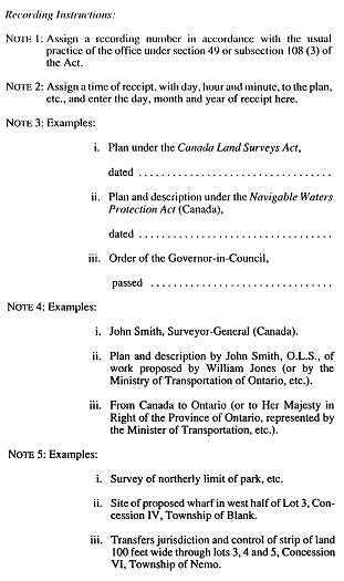
5. The land registrar shall endorse on a plan, description or order recorded under section 2 and on the duplicate received therewith, if any, his or her certificate in Form 3. R.R.O. 1990, Reg. 992, s. 5.
6. (1) Despite section 2, where, before the 1st day of April, 1967, an abstract index was kept for land in a national park or Indian reserve, the plans, descriptions and orders to which section 2 applies may be recorded in that abstract index in lieu of recording in the Canada Lands Index. R.R.O. 1990, Reg. 992, s. 6 (1).
(2) Where an abstract index is kept for land in a national park or Indian reserve and plans, descriptions and orders in respect of such land are recorded in the Canada Lands Index, the land registrar at the time of the recording of the first such plan, description or order shall enter in red ink under the proper heading in the abstract index the following notice:
“Subsequent dealings are recorded in the Canada Lands Index, volume (no.) commencing at page (no.)”.
R.R.O. 1990, Reg. 992, s. 6 (2).
7. Where a national park or Indian reserve is not set out in the Schedule, the Director may direct the proper land registrar to deal with land in such park or reserve in accordance with this Regulation. R.R.O. 1990, Reg. 992, s. 7.
8. Where land within a national park or Indian reserve is granted by the Crown in fee simple and the Crown grant is registered under the Land Titles Act or the Registry Act, the land registrar shall make an entry under the proper heading in the Canada Lands Index of the particulars of the grant with a reference to the parcel register or abstract index in which the grant is recorded. R.R.O. 1990, Reg. 992, s. 8.
9. The requirements of this Regulation may, with the approval of the Director, be varied to apply to special circumstances. R.R.O. 1990, Reg. 992, s. 9.
10. This Regulation applies in respect of any plan, description, order or instrument referred to in section 1 that is presented for filing, deposit or registration on or after the 1st day of April, 1967. R.R.O. 1990, Reg. 992, s. 10.
11. Where a plan, description or order relates to land that is the whole or a part of a national park or Indian reserve and the land is registered under the Land Titles Act with Her Majesty in right of Canada as the registered owner, the plan, description or order shall be recorded under that Act in the parcel register for the land. R.R.O. 1990, Reg. 992, s. 11.
SCHEDULE
Column 1 |
Column 2 | |||
Registry Division |
National Parks and Indian Reserves | |||
1. Algoma (No. 1) |
1. Indian Reserves | |||
Garden River No. 14 | ||||
Govlais Bay No. 15A | ||||
Gros Cap No. 49 | ||||
Gros Cap Indian Village No. 49A | ||||
Kapuskasing No. 83 | ||||
Missanabie No. 62 | ||||
Mississagi River No. 8 | ||||
Obedjiwan No. 15E | ||||
Rankin Location No. 15D | ||||
Serpent River No. 7 | ||||
Spanish River No. 5 | ||||
Thessalon No. 12 | ||||
2. Brant (No. 2) |
2. Indian Reserves | |||
Glebe Farm No. 40B | ||||
New Credit No. 40A (Tuscarora Twp.) | ||||
Six Nations No. 40 (Tuscarora and Onondaga Twps.) | ||||
3. Bruce (No. 3) |
3. Indian Reserves | |||
Cape Crocker No. 27 | ||||
Chief’s Point No. 28 | ||||
Saugeen No. 29 | ||||
Saugeen Hunting Ground No. 60 | ||||
National Parks | ||||
Flower Pot Island (part of Georgian Bay Islands National Park) | ||||
4. Ottawa-Carleton (No. 5) |
4. (Reserved) | |||
5. Cochrane (No. 6) |
5. Indian Reserves | |||
Abitibi No. 70 | ||||
Constance Lake No. 92 | ||||
English River No. 66 | ||||
Flying Post No. 73 | ||||
Moose Factory No. 68 | ||||
New Post No. 69 | ||||
6. Dufferin (No. 7) |
6. (Reserved) | |||
7. Dundas (No. 8) |
7. (Reserved) | |||
8. Port Hope (No. 9) |
8. (Reserved) | |||
9. Newcastle (No. 10) |
9. (Reserved) | |||
10. Elgin (No. 11) |
10. (Reserved) | |||
11. Essex (No. 12) |
11. National Parks | |||
Point Pelee | ||||
12. Frontenac (No. 13) |
12. National Parks | |||
Cedar Island (part of St. Lawrence Islands National Park) | ||||
13. Glengarry (No. 14) |
13. Indian Reserves | |||
Part of Cornwall Island Indian Reserve No. 59 comprising the following islands: | ||||
Butternut | ||||
The Cairn | ||||
Clark | ||||
Colquhoun (E & W) | ||||
Grape | ||||
Hamilton | ||||
Jacobs | ||||
Little Hog | ||||
Renshaw | ||||
Ross | ||||
Squaw | ||||
Stanley | ||||
St. Francis | ||||
Third Crab | ||||
Thompson | ||||
14. Grenville (No. 15) |
14. Indian Reserves | |||
Part of Cornwall Island Indian Reserve No. 59 comprising the following islands: | ||||
Drummond | ||||
Duck | ||||
Grass | ||||
Lame Squaw | ||||
Pier | ||||
Spencer | ||||
15. Grey North (No. 16) |
15. (Reserved) | |||
16. Grey South (No. 17) |
16. (Reserved) | |||
17. Haldimand (No. 18) |
17. Indian Reserves | |||
New Credit No. 40A (Oneida Twp.) | ||||
Six Nations No. 40 (Oneida Twp.) | ||||
18. Haliburton (No. 19) |
18. (Reserved) | |||
19. Halton (No. 20) |
19. (Reserved) | |||
20. Hastings (No. 21) |
20. Indian Reserves | |||
Tyendinaga No. 38 | ||||
21. Huron (No. 22) |
21. (Reserved) | |||
22. Kenora (No. 23) |
22. Indian Reserves | |||
Agency No. 30 | ||||
Attawapiskat No. 91 | ||||
Attawapiskat No. 91A | ||||
Big Island No. 31D | ||||
Big Island No. 31E | ||||
Big Island No. 31F | ||||
Big Island No. 37 | ||||
Big Trout Lake No. 84 | ||||
Caribou Lake No. 87 | ||||
Cat Lake No. 63C | ||||
Eagle Lake No. 27 | ||||
English River No. 21 | ||||
Factory Island No. 1 | ||||
Fort Albany No. 67 | ||||
Fort Hope No. 64 | ||||
Fort Severn No. 89 | ||||
Islington No. 29 | ||||
Kenora No. 38B | ||||
Lac Seul No. 28 | ||||
Lake of the | ||||
Woods No. 31B | ||||
Woods No. 31C | ||||
Woods No. 31G | ||||
Woods No. 31H | ||||
Woods No. 34 | ||||
Woods No. 35J | ||||
Woods No. 37 | ||||
Woods No. 37B | ||||
Marten Falls No. 65 | ||||
Naongashing No. 31A | ||||
Naongashing No. 35A | ||||
Northwest | ||||
Angle No. 33B | ||||
Angle No. 34C | ||||
Angle No. 37B | ||||
Obabikong No. 35B | ||||
One Man Lake No. 29 | ||||
Osnaburgh No. 638 | ||||
Pikangikum No. 14 | ||||
Rat Portage No. 38A | ||||
Sabaskong Bay No. 32C | ||||
Sabaskong Bay No. 35C | ||||
Sabaskong Bay No. 35D | ||||
Sabaskong Bay No. 35F | ||||
Sabaskong Bay No. 35H | ||||
Sachigo Lake No. 85 | ||||
Sandy Lake No. 88 | ||||
Shoal Lake No. 31J | ||||
Shoal Lake No. 34B1 | ||||
Shoal Lake No. 34B2 | ||||
Shoal Lake No. 37A | ||||
Shoal Lake No. 39 | ||||
Shoal Lake No. 39A | ||||
Shoal Lake No. 40 | ||||
Swan Lake No. 29 | ||||
The Dalles No. 38C | ||||
Wabauskang No. 21 | ||||
Wabigoon Lake No. 27 | ||||
Whitefish Bay No. 32A | ||||
Whitefish Bay No. 33A | ||||
Whitefish Bay No. 34A | ||||
Winisk No. 90 | ||||
Wunnamin Lake No. 86 | ||||
Yellow Girl Bay No. 32B | ||||
23. Kent (No. 24) |
23. Indian Reserves | |||
Moravian No. 47 | ||||
24. Lambton (No. 25) |
24. Indian Reserves | |||
Kettle Point No. 44 | ||||
Sarnia No. 45 | ||||
Walpole Island No. 46 | ||||
25. Lanark North (No. 26) |
25. (Reserved) | |||
26. Lanark South (No. 27) |
26. (Reserved) | |||
27. Leeds (No. 28) |
27. National Parks | |||
(Part of St. Lawrence Islands National Park) | ||||
Mermaid Is. |
) | |||
Aubrey Is. |
) | |||
Beau Rivage Is. |
) in front of the Twp. of Leeds | |||
Gordon Is. |
) | |||
Camelot Is. |
) | |||
Endymion Is. |
) | |||
Constance Is. |
) in front of the Twp. of Lansdowne | |||
Georgina Is. |
) | |||
Adelaide Is. (in front of the Twp. of Yonge) | ||||
Stovin Is. (in front of the Twp. of Elizabethtown) | ||||
(Parts of Grenadier Is.) (in front of the Twp. of Escott) | ||||
Islands 7A & 7B | ||||
Mallorytown Landing (Twp. of Yonge) | ||||
28. Lennox (No. 29) |
28. (Reserved) | |||
29. Niagara (No. 30) |
29. (Reserved) | |||
30. Manitoulin (No. 31) |
30. Indian Reserves | |||
Cockburn Is. No. 19 | ||||
Manitoulin Is. No. 26 | ||||
Pointe Grondine No. 3 | ||||
Sheguiandah No. 24 | ||||
Sheshegwaning No. 20 | ||||
Sucker Creek No. 23 | ||||
West Bay No. 22 | ||||
Whitefish River No. 4 | ||||
31. Middlesex East (No. 33) |
31. (Reserved) | |||
32. Middlesex West (No. 34) |
32. Indian Reserves | |||
Caradoc No. 42 | ||||
Oneida No. 41 | ||||
33. Muskoka (No. 35) |
33. National Parks | |||
Part of Georgian Bay Islands National Park: | ||||
Beausoleil Is. Islands Nos. 92, 93, part of 95, 147-0 & 154 |
) |
opposite the geographic Township of Baxter, now in the Township of Georgian Bay | ||
) | ||||
parts of Is. No. 75, part of Is. No. 139, Is. No. 200 |
) |
opposite the geographic Township of Gibson, now in the Township of Georgian Bay | ||
) | ||||
Islands Nos. 220, 221, 226, 355, 356, 358, 359, 371, 371A, 372, 373, 374, 383, 397, 400, 401½ & 402 |
) |
opposite the former Township of Freeman, now in the Township of Georgian Bay | ||
) | ||||
) | ||||
Indian Reserves | ||||
Gibson No. 31 (now in the Township of Georgian Bay formerly in the Township of Gibson) | ||||
Moose Point No. 79 (now in the Township of Georgian Bay, formerly in the Township of Freeman) | ||||
34. Nipissing (No. 36) |
34. Indian Reserves | |||
Bear Is. (Lake Timagami) | ||||
Nipissing No. 10 (Lake Nipissing) | ||||
35. Norfolk (No. 37) |
35. (Reserved) | |||
36. Northumberland East (No. 38) |
36. (Reserved) | |||
37. Northumberland West (No. 39) |
37. Indian Reserves | |||
Alderville No. 37 | ||||
38. Durham (No. 40) |
38. Indian Reserves | |||
Scugog No. 34 | ||||
39. Oxford (No. 41) |
39. (Reserved) | |||
40. Parry Sound (No. 42) |
40. Indian Reserves | |||
Dokis No. 9 | ||||
French River No. 13 | ||||
Henvey Inlet No. 2 | ||||
Magnetawan No. 1 | ||||
Naiscoutaing No. 17A | ||||
Parry Island No. 16 | ||||
Shawanaga No. 17 | ||||
Shawanaga No. 17B | ||||
National Parks | ||||
Part of Georgian Bay Islands National Park: | ||||
Islands Nos. 473, 497 and 504 (McQuaid Island) (opposite Conger Twp.) | ||||
41. Peel (No. 43) |
41. (Reserved) | |||
42. Perth (No. 44) |
42. (Reserved) | |||
43. Peterborough (No. 45) |
43. Indian Reserves | |||
Islands in the Trent Waters | ||||
Nos. 36A (Islands in Pigeon, Buckhorn and Stony Lakes) | ||||
Curve Lake No. 35 | ||||
Curve Lake No. 35A | ||||
(Fox Island in Buckhorn Lake) | ||||
Hiawatha No. 36 | ||||
Sugar Island No. 37A | ||||
44. Prescott (No. 46) |
44. (Reserved) | |||
45. Prince Edward (No. 47) |
45. (Reserved) | |||
46. Rainy River (No. 48) |
46. Indian Reserves | |||
Agency No. 1 | ||||
Big Grassy River No. 35G | ||||
Big Is. Mainland No. 93 | ||||
Couchiching No. 16A | ||||
Manitou Rapids No. 11 | ||||
Neguaguon Lake No. 25D | ||||
Rainy Lake No. 17A | ||||
Rainy Lake No. 17B | ||||
Rainy Lake No. 18C | ||||
Rainy Lake No. 26A | ||||
Rainy Lake No. 26B | ||||
Rainy Lake No. 26C | ||||
Seine River No. 23A | ||||
Seine River No. 23B | ||||
Sturgeon Falls No. 23 | ||||
47. Renfrew (No. 49) |
47. Indian Reserves | |||
Golden Lake No. 39 | ||||
48. Russell (No. 50) |
48. (Reserved) | |||
49. Simcoe (No. 51) |
49. Indian Reserves | |||
Christian Islands No. 30 (3 islands) Christian Island No. 30A (Part of Lot 20, Con. XXI, Twp. of Tiny) | ||||
Rama No. 32 | ||||
50. Stormont (No. 52) |
50. Indian Reserves | |||
Part of Cornwall Island Indian Reserve No. 59 comprising the following islands: | ||||
Cornwall | ||||
First Crab | ||||
Pilon | ||||
51. Sudbury (No. 53) |
51. Indian Reserves | |||
Chapleau No. 61 | ||||
Chapleau No. 61A | ||||
Chapleau No. 74 | ||||
Chapleau No. 74A | ||||
Chapleau No. 75 | ||||
Mattagami No. 71 | ||||
Mountbatten No. 76A | ||||
Wanapitei No. 11 | ||||
Whitefish Lake No. 6 | ||||
52. Timiskaming (No. 54) |
52. Indian Reserves | |||
Matachewan No. 72 | ||||
53. Thunder Bay (No. 55) |
53. Indian Reserves | |||
Aroland No. 83 | ||||
Fort William No. 52 | ||||
Gull River No. 55 | ||||
Jackfish No. 57 | ||||
Lac des Milles Lacs No. 22A1 | ||||
Lake Helen Indian Settlement | ||||
Long Lake No. 58 | ||||
Long Lake No. 77 | ||||
MacDairmid Indian Settlement | ||||
McIntyre Bay No. 54 | ||||
Mobert No. 82 | ||||
Osnaburgh No. 63A | ||||
Pays Plat No. 51 | ||||
Pic River No. 50 | ||||
Red Rock No. 53 | ||||
Seine River No. 22A2 | ||||
White Sand River No. 81 | ||||
54. Victoria (No. 59) |
54. Indian Reserves | |||
Islands in the Trent Waters No. 36A | ||||
55. Waterloo North (No. 58) |
55. (Reserved) | |||
56. Revoked: O. Reg. 124/05, s. 1 (2). | ||||
57. Wellington North (No. 60) |
57. (Reserved) | |||
58. Wellington South (No. 61) |
58. (Reserved) | |||
59. Wentworth (No. 62) |
59. (Reserved) | |||
60. Toronto (No. 63) |
60. (Reserved) | |||
61. Toronto Boroughs (No. 64) |
61. (Reserved) | |||
62. York Region |
62. Indian Reserves | |||
Georgina Islands No. 33 | ||||
(3 islands — Georgina Is., Snake Is. and Fox Is.) | ||||
63. Waterloo South (No. 67) |
63. (Reserved) | |||
R.R.O. 1990, Reg. 992, Sched.; O. Reg. 124/05, s. 1.
FORM 1
CANADA LANDS INDEX
Registry Act
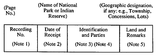
R.R.O. 1990, Reg. 992, Form 1.
FORM 2
INDEX TO CANADA LANDS INDEX
Registry Act
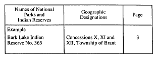
R.R.O. 1990, Reg. 992, Form 2.
FORM 3
CERTIFICATE OF RECORDING
Registry Act
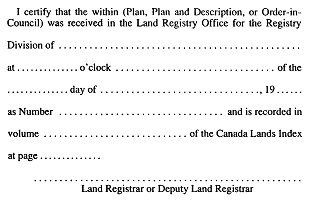
R.R.O. 1990, Reg. 992, Form 3.