O. Reg. 42/96: PERFORMANCE STANDARDS FOR THE PRACTICE OF CADASTRAL SURVEYING, Surveyors Act, R.S.O. 1990, c. S.29
Surveyors Act
Loi sur les arpenteurs-géomètres
ONTARIO REGULATION 42/96
PERFORMANCE STANDARDS FOR THE PRACTICE OF CADASTRAL SURVEYING
Historical version for the period April 20, 1996 to June 6, 2010.
No amendments.
This Regulation is made in English only.
CONTENTS
Sections | ||
INTERPRETATION |
1 | |
FIELD SURVEY STANDARDS |
2-9 | |
PLANS |
10-25 | |
SURVEYOR’S REAL PROPERTY REPORT |
26-29 | |
Surveyor’s certificate (section 25 of the Regulation) |
PART I
INTERPRETATION
1. In this Regulation,
“coordinate survey” means a survey made for the purpose of establishing the location of points on the surface of the earth by geographic or grid coordinates;
“imperial units” means units of measurement in feet and decimals of a foot;
“licensed member” means a member of the Association of Ontario Land Surveyors licensed to engage in the practice of cadastral surveying;
“lot” means a lot or any other area defined and designated by an original survey or by a registered plan;
“metric units” means units of measurement in metres and decimals of a metre;
“monument” includes any monument referred to in Ontario Regulation 525/91 under the Surveys Act and any other thing, device or object used to mark or witness a boundary of surveyed lands;
“original survey” has the same meaning as in section 1 of the Surveys Act;
“property identifier” means a property identifier assigned under subsection 21 (2) or (4) of the Registry Act or under subsection 141 (2) or (4) of the Land Titles Act;
“subdivision unit” means,
(a) a lot shown on the original plan of an original survey and includes a section, block, gore, reserve, common, mining location or mining claim, or
(b) a lot, block, part or other unit of land shown on a plan registered or deposited under the Registry Act or the Land Titles Act. O. Reg. 42/96, s. 1.
PART II
FIELD SURVEY STANDARDS
2. This Part applies to surveys performed by a licensed member while engaged in the practice of cadastral surveying. O. Reg. 42/96, s. 2.
3. When undertaking a survey, a licensed member shall,
(a) refer to the documentary evidence related to the land under survey and the land adjoining the land under survey;
(b) carry out a thorough field investigation for the best available evidence of all lines, boundaries, and corners of the land under survey; and
(c) give priority to the evidence in accordance with common law and statute law. O. Reg. 42/96, s. 3.
4. The error of closure of field data, in respect of the perimeter of each parcel of land or closed traverse, shall not exceed,
(a) for the first 30 metres of perimeter, an error of 30 millimetres;
(b) for the next 300 metres in excess of 30 metres of perimeter, an error of 6 millimetres per 30 metres;
(c) for the next 240 metres in excess of 330 metres of perimeter, an error of 3 millimetres per 30 metres; and
(d) for a total perimeter of more than 570 metres, an error of one part in 5,000. O. Reg. 42/96, s. 4.
5. Bearings shall be,
(a) determined from astronomic or gyroscopic observations;
(b) derived from a line of known astronomic bearing if survey evidence of such a line exists on the ground and the position of the line is described on the plan being prepared; or
(c) derived from monuments in a coordinate survey. O. Reg. 42/96, s. 5.
6. The position of topographic information required under section 21 shall be determined by measurements at such intervals as the complexity of the topographic information demands and to such extent as will enable relocation of the topographic information. O. Reg. 42/96, s. 6.
7. All survey measurements shall be verified by mathematical closure or independent measurement. O. Reg. 42/96, s. 7.
8. If a survey is made for the purpose of defining, locating or describing a line, boundary or corner of a unit of land in relation to the regulated level of a body of water or defining a boundary in reference to an elevation, and no permanent bench mark exists within 300 metres of the site of the survey, a permanent bench mark, defined by a monument referred to in clause 2 (1) (a), (b), (d), (e) or (f) of Ontario Regulation 525/91 or other durable and stable object, shall be established at or near the site. O. Reg. 42/96, s. 8.
9. For each survey, field notes shall be prepared in the field and shall contain a clear and detailed account of everything found, observed and done in the field in the course of and relevant to the survey. O. Reg. 42/96, s. 9.
10. This Part applies to plans executed by a licensed member while engaged in the practice of cadastral surveying. O. Reg. 42/96, s. 10.
11. The word “survey” is not to be used in the title of any plan unless the plan has been prepared from a survey of land made for the purpose of establishing, locating, defining or describing any line, boundary, or corner of a parcel of land, or land covered with water. O. Reg. 42/96, s. 11.
12. (1) A plan shall,
(a) be drawn on translucent linen or on translucent plastic material that is of durable quality and will not crack or break;
(b) be rectangular;
(c) be drawn and signed in black india ink or, if the plan is drawn on translucent plastic material, in black adhesion type ink;
(d) be drawn to a scale or scales sufficient for clarity of all particulars on the plan;
(e) be prepared to a drafting standard that will permit legible and accurate copies to be made from it; and
(f) not be coloured.
(2) The only handwriting to appear on a plan shall be the original signatures of persons required to sign the plan and the dates of the signatures.
(3) Despite clauses (1) (a) and (c), a plan may be in whole or in part a photographic reproduction on plastic material that is of durable quality and will not crack or break, but all additions to the photographic reproduction shall be in black adhesion type ink, and signatures shall not be reproductions.
(4) Despite clause (1) (c), the title, legend and margin and any applicable certificates and forms prescribed by the regulations under which the plan is prepared may be preprinted on a plan in a manner that is permanent and permits accurate and legible copies of the plan to be made. O. Reg. 42/96, s. 12.
13. (1) A plan shall show,
(a) every right of way and easement affecting the land shown on the plan that is,
(i) described in a registered instrument, or
(ii) shown on a registered or deposited plan;
(b) the bearing and length of each straight line forming any surveyed limit or part of any limit, except that, in the case of a tier of subdivision units that is shown by the dimensions to be a series of parallelograms, the direction of each of the side lines of the subdivision units may be indicated by the bearings at both ends of the tier;
(c) the radius, arc length, chord length and chord bearing of each curved line forming any limit or part of any limit;
(d) the perpendicular or radial widths of all streets, lanes and public passages within the surveyed area of which the limits are parallel or concentric;
(e) the straight line distance and bearing between the points of intersection of street limits on the same side of the street and, where all or part of any intersection is on a curve, the radius, arc length, chord length and chord bearing of the curved portion;
(f) the location of the radial centre of an arc that forms a cul-de-sac, clearly defined with reference to the street or streets connected to the cul-de-sac;
(g) an accurately plotted simple north point;
(h) the scale to which the plan is drawn; and
(i) if applicable, the name of the holder of the certificate of authorization.
(2) The scale to which a plan is drawn shall be expressed in numerical form and a scale bar clearly identified as representing either feet or metres shall also be shown on the plan.
(3) If space does not permit the showing of bearings and lengths, as required by clauses (1) (b) and (c), in their normal position, they may be shown in schedule form on the plan. O. Reg. 42/96, s. 13.
14. (1) All distances on a plan shall be shown either in imperial units or in metric units.
(2) A note in bold printing shall be included in a conspicuous position on every plan that indicates either that the distances shown on the plan,
(a) are in metres and can be converted to feet by dividing by 0.3048, if distances on the plan are shown in metric units; or
(b) are in feet and can be converted to metres by multiplying by 0.3048, if distances on the plan are shown in imperial units.
(3) If a survey has been integrated with a coordinate survey, notes shall be included on the plan of survey that indicate that,
(a) the distances shown on the plan are adjusted ground or grid distances and can be used to compute grid or ground distances by multiplying or dividing the distances by the stated combined scale factor; and
(b) the coordinate survey represented by the plan is based on the stated projection, zone and datum. O. Reg. 42/96, s. 14.
15. Directions shall be shown on a plan in quadrantal bearings. O. Reg. 42/96, s. 15.
16. (1) The origin of the bearings shall be noted on a plan and,
(a) if bearings have been determined from astronomic or gyroscopic observations, a note shall be included on the plan indicating whether the bearings are,
(i) astronomic or gyroscopic, derived from observations on Polaris, or other stars or planets, or derived from gyroscopic observations, and
(ii) referred to the meridian at a given longitude or through a stated point on the ground definable by survey;
(b) if bearings have been derived from survey evidence of a line of known astronomic bearing, a note shall be included on the plan indicating the source of the bearings, the specified limit from which they are derived and the stated bearing; or
(c) if bearings have been derived from a coordinate survey, a note shall be included on the plan indicating that the bearings are grid bearings, are derived from the specified horizontal control monuments with stated values and are referred to the stated central meridian.
(2) The line referred to in clause (1) (b) and the evidence used to re-establish it shall be described on the plan. O. Reg. 42/96, s. 16.
17. (1) By the use of light, broken or unbroken, lines of uniform width, a plan shall clearly and accurately show,
(a) sufficient data to enable the identification of,
(i) the limits of existing subdivision units included within the land surveyed,
(ii) the limits defined by registered instruments or parcels affecting land included within the land surveyed, and
(iii) the limits of subdivision units adjoining the land surveyed and the limits defined by instruments or parcels referred to in subclause (e) (ii) that join or intersect the perimeter of the land surveyed;
(b) sufficient data to enable the location of the parcel of land surveyed to be ascertained in relation to the limits of the lot of which it is a part;
(c) the identifying numbers, letters or words of the existing subdivision units included within and adjoining the land surveyed;
(d) if the plan includes land in a part of Ontario designated under Part II of the Land Registration Reform Act, the property identifiers assigned to,
(i) the land surveyed, and
(ii) the land adjoining the land surveyed;
(e) if property identifiers have not been assigned, the numbers of,
(i) the registered instruments or parcels referred to in subclause (a) (ii), and
(ii) the registered instruments or parcels that define the limits of land adjoining the land surveyed; and
(f) the new headings in the abstract index for each parcel included in the plan, if the plan includes land in an area that has been divided into parcels for abstract purposes under subsection 83 (3) of the Registry Act.
(2) Subclauses (1) (d) (ii) and (e) (ii) do not apply in respect of an undivided subdivision unit created by a registered plan of subdivision. O. Reg. 42/96, s. 17.
18. There shall be shown on a plan by solid lines of uniform width significantly heavier than the lines referred to in section 17,
(a) the boundaries of the land being surveyed;
(b) in the case of a plan showing new subdivision units, the limits of the new subdivision units and the identifying numbers, letters or words of the new subdivision units; or
(c) in the case of a plan showing boundaries sought to be confirmed under the Boundaries Act, the boundaries sought to be confirmed. O. Reg. 42/96, s. 18.
19. A plan shall show,
(a) the position and form of all survey evidence found, conflicting or otherwise;
(b) the procedure used in re-establishing all existing boundaries forming part of a survey or on which a survey is dependent; and
(c) the source of the distance or direction, if a distance or direction is set. O. Reg. 42/96, s. 19.
20. (1) If a measurement of distance or direction to be shown on a plan differs from that shown on a previously registered or deposited plan or contained in a description in a previously registered instrument or parcel, the measured distance or direction shall be identified on the plan and the corresponding distance or direction shown on the most recently registered or deposited plan or contained in the description in the most recently registered instrument or parcel shall be shown on the plan followed by such information as is required to identify its source.
(2) Sufficient data shall be shown on a plan to permit the calculation of the error of closure in respect of the limits of each parcel of land shown on the plan.
(3) For the purposes of subsection (2), the errors of closure set out in section 4 apply. O. Reg. 42/96, s. 20.
21. (1) On a plan of survey,
(a) all topographic information shall be shown,
(i) that forms, controls or marks the position of a boundary of the surveyed parcel,
(ii) that may indicate an interest in the title to the surveyed parcel, or
(iii) that indicates an encroachment from the surveyed parcel onto the adjacent lands or from the adjacent lands onto the surveyed parcel; and
(b) all survey data necessary to define the position of topographic information required by clause (a) shall be shown and, in the case of subclause (a) (i), may be in schedule form.
(2) Topographic information that is not required under clause (1) (a) shall not be shown on a plan of survey prepared for registration or deposit in a land registry office.
(3) Despite subsection (2), sufficient topographic information to illustrate the position of the boundary being surveyed in relation to the topographic information adjoining the boundary may be shown.
(4) Subclauses (1) (a) (i) and (iii) do not apply in the case of existing boundaries of a previously surveyed public highway if the current plan of survey is prepared for the purpose of widening the highway. O. Reg. 42/96, s. 21.
22. If a plan shows a part of a street or highway that has been stopped up or closed, the plan shall include a reference to the by-law or other instrument by which the street or highway was stopped up or closed and to the registration number of,
(a) the by-law, if passed on or after March 29, 1873, in respect of lands registered under the Registry Act at the time the by-law was passed, or if passed on or after February 12, 1987, in respect of lands registered under the Land Titles Act; or
(b) the other instrument. O. Reg. 42/96, s. 22.
23. If a plan shows a boundary that was confirmed under the Surveys Act or confirmed and certified under the Boundaries Act or a predecessor thereof, a reference to the confirmation and to the registered plan number, where applicable, shall be included on the plan. O. Reg. 42/96, s. 23.
24. (1) Every plan shall bear a title that includes,
(a) the designation of every existing subdivision unit, except those subdivision units designated as parts, any portion of which is included in the land surveyed;
(b) the new headings in the abstract index for each parcel included in the plan, if the plan includes land in an area that has been divided into parcels for abstract purposes under subsection 83 (3) of the Registry Act;
(c) the name of the geographic township, if any, where the land was situate at the time of the original survey, except in the case of patented land within a registered plan; and
(d) the name of the municipality and of the county, district, metropolitan or regional municipality where the land was situate on the day the plan was signed by the licensed member.
(2) If a plan creates new subdivision units, the references to existing subdivision units, new abstract headings and the name of the geographic township required by subsection (1) to be included in the title of a plan may, instead, be set out in a schedule near the upper right corner of the plan relating them to the new subdivision units. O. Reg. 42/96, s. 24.
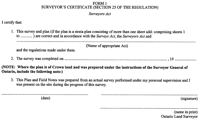
25. Except as required under any statute of Ontario, and the regulations thereunder, every plan shall be certified by a licensed member in Form 1. O. Reg. 42/96, s. 25.
PART IV
SURVEYOR’S REAL PROPERTY REPORT
26. For the purpose of this Part, a surveyor’s real property report is a survey that locates a building or structure in relation to the boundaries of a unit of land. O. Reg. 42/96, s. 26.
27. (1) The documentation for a surveyor’s real property report shall consist of a plan of survey and a written report.
(2) If the plan and the written report are separate documents, the plan shall include a note indicating that the written report is to be read in conjunction with the plan.
(3) The plan shall include a note specifying the name of the client for whom the surveyor’s real property report was prepared. O. Reg. 42/96, s. 27.
28. In addition to the requirements of Part III, the surveyor’s real property report shall show,
(a) all buildings and structures and the foundations of all buildings and structures under construction on the lands and their distances from the boundaries of the lands;
(b) the number of storeys of all buildings and their external construction materials; and
(c) the municipal address of the property, if any. O. Reg. 42/96, s. 28.
29. Omitted (provides for coming into force of provisions of this Regulation). O. Reg. 42/96, s. 29.
FORM 1
SURVEYOR’S CERTIFICATE (SECTION 25 OF THE REGULATION)
Surveyors Act
O. Reg. 42/96, Form 1.