O. Reg. 415/96: ZONING AREAS - CITY OF TORONTO, MUNICIPALITY OF METROPOLITAN TORONTO, Under: Planning Act, R.S.O. 1990, c. P.13
Planning Act
Loi sur l’aménagement du territoire
ONTARIO REGULATION 415/96
ZONING AREAS — CITY OF TORONTO, MUNICIPALITY OF METROPOLITAN TORONTO
Consolidation Period: From September 11, 1996 to the e-Laws currency date.
No amendments.
This Regulation is made in English only.
Order Deemed to be By-law
1. (1) This Order shall be deemed for all purposes except the purposes of section 24 of the Act to be a by-law passed by the Council of the Corporation of the City of Toronto to further amend City of Toronto By-law 438-86, being “A By-law to regulate the use of land and the erection, use, bulk, height, spacing of and other matters relating to buildings and structures and to prohibit certain uses of lands and the erection and use of certain buildings and structures in various areas of the City of Toronto” as amended to the date this Order comes into force (“By-law 438-86”), with respect to the use of land and structures on Ward’s Island and Algonquin Island and shall be read in conjunction with By-law 438-86. O. Reg. 415/96, s. 1 (1).
(2) The amendment to By-law 438-86 shall be deemed to be in force on the day this Order comes into force. O. Reg. 415/96, s. 1 (2).
(3) The deemed by-law shall be referred to as by-law number 1996-0414 of the City of Toronto. O. Reg. 415/96, s. 1 (3).
Interpretation
2. (1) The definition of “Algonquin Island Residential Area” in subsection 2 (1) of By-law 438-86 is amended by deleting the words “except for the lands municipally known in 1994 as 10 Nottawa Avenue, 4 Omaha Avenue, 6 Omaha Avenue and 27 Seneca Avenue”. O. Reg. 415/96, s. 2 (1).
(2) The definition of “Ward’s Island Residential Area” in subsection 2 (1) of By-law 438-86 is deleted and the following substituted:
“Ward’s Island Residential Area” means the part of the City of Toronto delineated by heavy lines and shown on the following map:
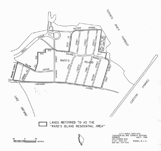
O. Reg. 415/96, s. 2 (2).
Application
3. Sections 3 to 10 of this Order apply to the following lands situated on the lands known as Algonquin Island and Ward’s Island within the City of Toronto in The Municipality of Metropolitan Toronto, more particularly described as,
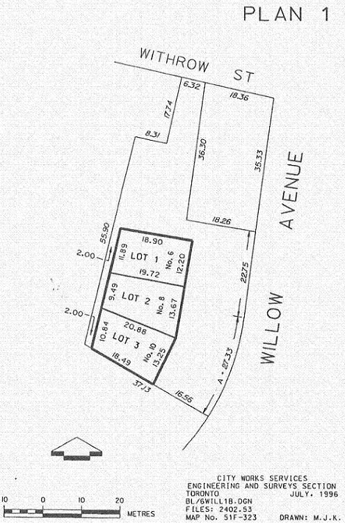
(a) lands known municipally as of August 12, 1996 as 10 Nottawa Avenue, 4 and 6 Omaha Avenue, 27 Seneca Avenue, 7 and 21 Fifth Street, 7 and 13 Fourth Street, 4 Lenore Avenue, 9, 10, 11 and 13 Second Street and 1 and 3 Third Street, 4, 102 and 108 Lakeshore Avenue, 10 and 20 Withrow Street, 18 Wyandot Avenue and 101 Cibola Avenue; and
(b) lands outlined by heavy lines on Plan 1 attached to, and forming part of, this Order as Schedule 1. O. Reg. 415/96, s. 3.
Applicability of By-law 438-86
4. (1) The provisions of By-law 438-86 shall continue to apply to the Algonquin Island Residential Area and the Ward’s Island Residential Area, except as otherwise provided for in this Order. O. Reg. 415/96, s. 4 (1).
(2) The italicized expressions contained in this Order shall have the same meaning as the definitions contained in By-law 438-86, except as otherwise provided for in this Order. O. Reg. 415/96, s. 4 (2).
Permitted Uses
5. Despite sections 5 (1) (f), 6 (1) (f) and 12 (2) 295 (a) of By-law 438-86, the following uses are permitted for the lands as set out in Section 3:
1. A semi-detached house on the lands known municipally on August 12, 1996 as 4 and 6 Omaha Avenue.
2. A detached house on each lot on the lands known municipally on August 12, 1996 as 10 Nottawa and 27 Seneca and on each lot on the lands shown on Plan 1. O. Reg. 415/96, s. 5.
6. (1) Despite section 12 (1) 385 of By-law 438-86, on the lands known municipally on August 12, 1996 as those addresses set out in Column A below, the uses existing on those lands as of April, 1996 are permitted in addition to the uses listed in the corresponding row in Column B, if the residential gross floor area, non-residential gross floor area or any combination thereof, does not exceed the amount set out in the corresponding row in Column C.
Column A |
Column B |
Column C |
Address |
Proposed Use (s. refers to the By-law 438-86 section) |
Maximum Floor Area (square metres) |
102 Lakeshore Avenue |
those uses in s. 12 (1) 385 |
310 |
108 Lakeshore Avenue |
senior citizens’ facility |
205 |
101 Cibola Avenue |
those uses in s. 12 (1) 385 |
190 |
10 & 20 Withrow Street |
those uses in s. 12 (1) 385 |
358 |
18 Wyandot Avenue |
those uses in s. 12 (1) 385 |
378 |
O. Reg. 415/96, s. 6 (1).
(2) For the purposes of subsection (1),
“senior citizens’ facility” means a building used for community activities for senior citizens including, but not limited to, arts, crafts, physical, social, charitable and educational facilities, and not used for any residential or commercial purpose. O. Reg. 415/96, s. 6 (2).
Density
7. (1) Plan 2 showing footprints of new buildings on 4 and 6 Omaha Avenue is attached to and forms part of this Order as Schedule 2. O. Reg. 415/96, s. 7 (1).
(2) Despite subsection 6 (3) of By-law 438-86, no person shall erect or use a building or structure on any lot shown on Plan 2 that exceeds a residential gross floor area of 102 square metres. O. Reg. 415/96, s. 7 (2).
Building Footprint — Algonquin Island
8. Despite sections 6 (3) Part II 1, 2, 3, 4, 5 and 8 and 12 (2) 295 (g), (i), (j), (l) and (n) of By-law 438-86, no person shall erect a building or structure on any lot shown on Plan 2, having any portion of such building or structure above grade, unless it is located within the heavy line shown on Plan 2. O. Reg. 415/96, s. 8.
Front Yard Setback for New Construction — Ward’s Island
9. Despite section 12 (2) 295 (g) of By-law 438-86, no person shall erect or use a building or structure on a lot shown on Plan 1, where any part of the building or structure is located closer to the front lot line than 3.5 metres. O. Reg. 415/96, s. 9.
Accessory Buildings & Permitted Projections
10. Sections 8 and 9 of this Order do not apply to the type of structures permitted to project beyond the depth limit and into the required setback areas, as set out in sections 12 (2) 295 (r) and (s) of By-law 438-86. O. Reg. 415/96, s. 10.
Zoning and Height Maps
11. (1) District Map 51F-323 contained in Appendix “A” of By-law 438-86, as amended, is further amended by redesignating the lands as shown and outlined by heavy lines on Plan 3 attached to and forming part of this Order as Schedule 3. O. Reg. 415/96, s. 11 (1).
(2) Height and Minimum Lot Frontage Map 51F-323 contained in Appendix “B” of By-law No. 438-86, as amended, is further amended by designating the height limit for the lands as shown and outlined by heavy lines on Plan 4 attached to and forming part of this Order as Schedule 4. O. Reg. 415/96, s. 11 (2).
Frontage on a Street
12. Subsection 4 (11) of By-law 438-86 shall not apply to any lot shown on Plan 2. O. Reg. 415/96, s. 12.
Parking
13. Paragraph 12 (1) 387 of By-law 438-86 is amended by deleting the word “map” and substituting it with “maps” and adding the following map:
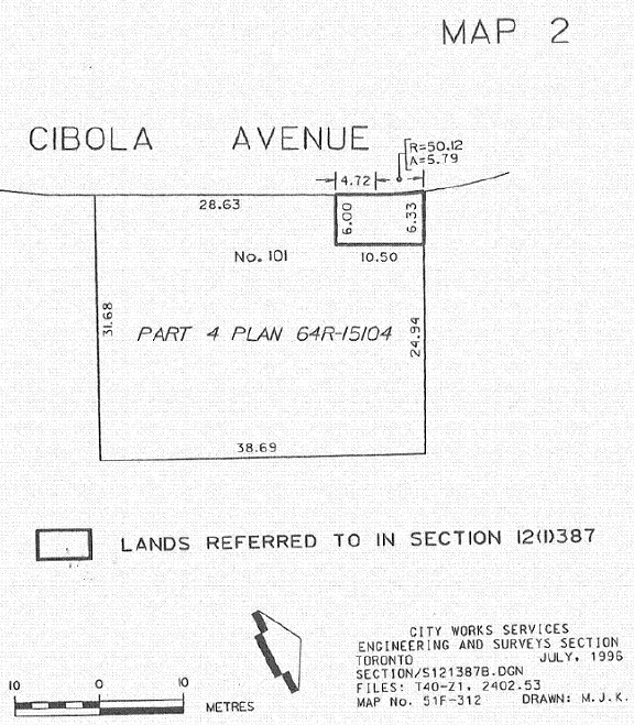
O. Reg. 415/96, s. 13.
SCHEDULE 1
O. Reg. 415/96, Sched. 1.
SCHEDULE 2

O. Reg. 415/96, Sched. 2.
SCHEDULE 3
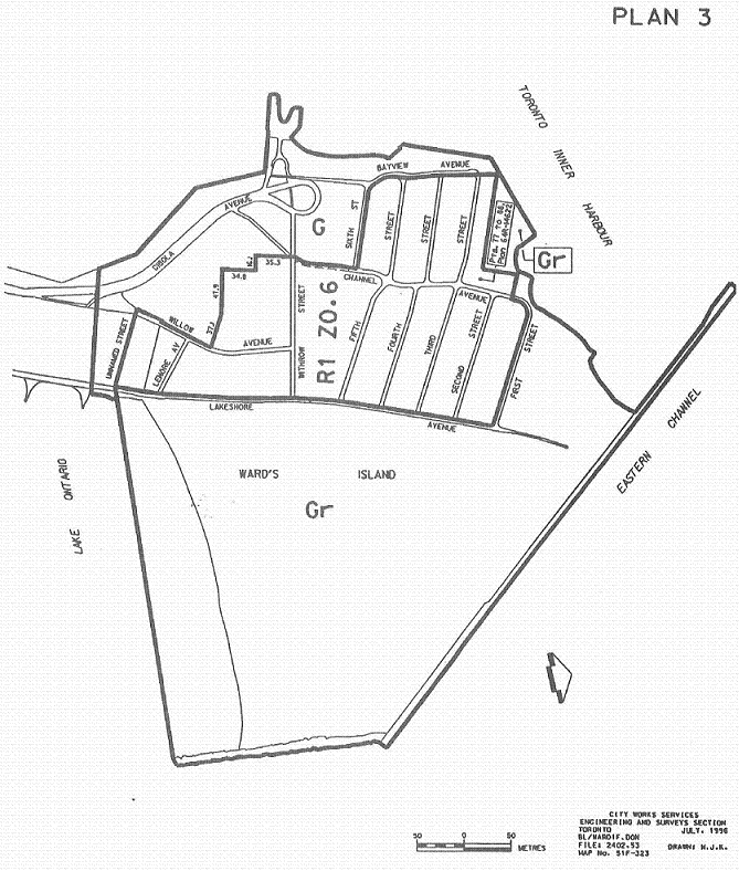
O. Reg. 415/96, Sched. 3
SCHEDULE 4
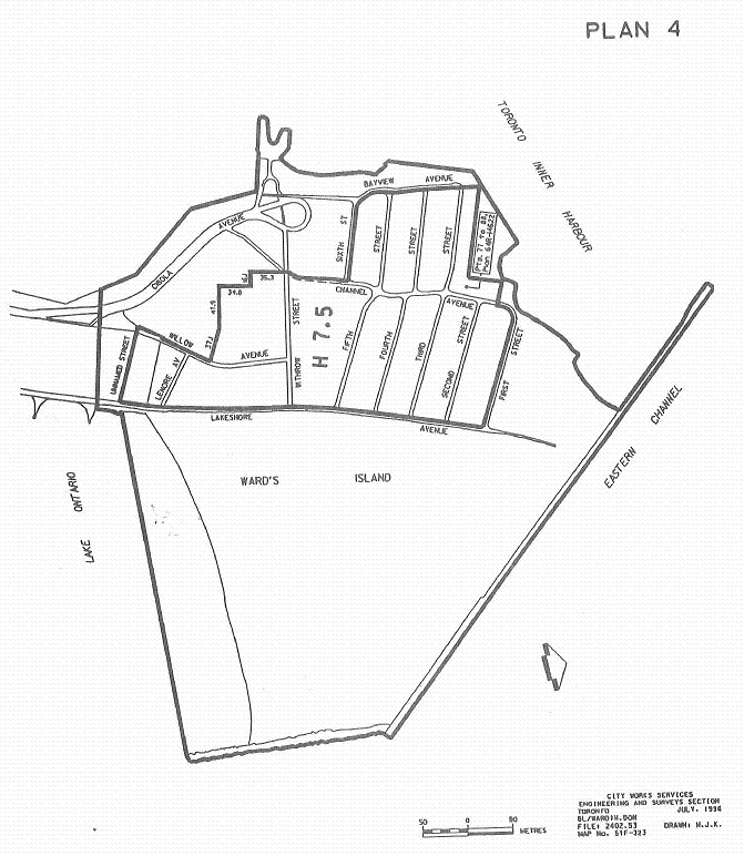
O. Reg. 415/96, Sched. 4.