

Bigwind Lake Provincial Park Management Plan (2026)
This document provides policy direction for the protection, development and management of Bigwind Lake Provincial Park and its resources.
Approval statement (2026)
July 13, 2026
The Ontario government is moving forward with select improvements to Bigwind Lake Provincial Park, including 10 new paddle-in backcountry campsites, a trail and upgrades to road access and parking to support low-impact outdoor recreation.
These improvements will expand opportunities for visitors to experience the park and contribute to local tourism and businesses in the region, while maintaining flexibility for future park development as conditions allow.
I am pleased to approve the Bigwind Lake Provincial Park Management Plan. The plan reflects the intent of the Ministry of the Environment, Conservation and Parks to enhance recreational opportunities for visitors and maintain the protection and health of local wildlife and the environment.
This document outlines the site-specific purpose and vision, policies, actions and implementation priorities for the park, and summarizes Indigenous community, stakeholder and public involvement that occurred as part of the planning process.
The plan for Bigwind Lake Provincial Park will guide the management of the park over the next 20 years or more. During that time, the management plan may be examined and adjusted to address emerging issues or changing conditions.
I wish to extend my sincere thanks to all those who participated in the planning process.
Jason Travers
Director, Ontario Parks Operations Branch
1. Introduction
Bigwind Lake Provincial Park is a 1,967-hectare (ha) natural environment class park
The park protects upland forests of sugar maple, hemlock and yellow birch, and low-lying swamps, marshes, and meadows. The park is currently non-operating, which means it offers low-intensity, self-guided recreational opportunities, such as hiking and paddling, but does not have staffing or maintained facilities and services.
This management plan:
- proposes the creation of four-season campgrounds, day-use areas, and backcountry camping facilities
- provides site-specific management policies that will guide the park’s operation over the next 20 years or more
The proposed facilities would make the park operational, enhancing recreational opportunities for visitors. Importantly, the plan is committed to maintaining the protection and health of local wildlife and the environment.
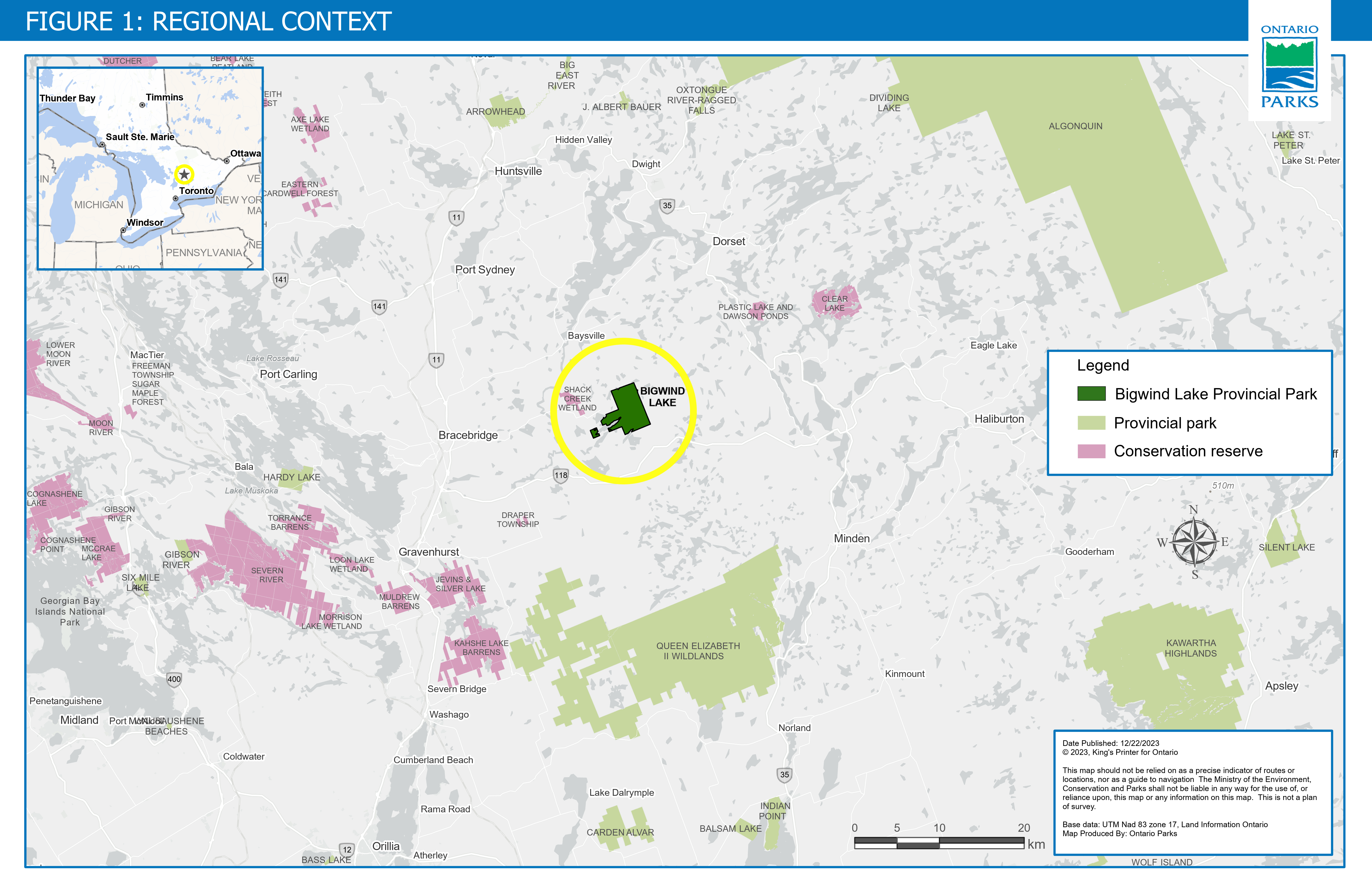
Figure 1 is a map showing the regional context of Bigwind Lake Provincial Park's location relative to the surrounding area in central Ontario. The park is east of the town of Bracebridge, south of the town of Baysville and west of the town of Haliburton. It is located south of Arrowhead Provincial Park, southwest of Algonquin Provincial Park, directly north of Queen Elizabeth II Wildlands Provincial Park and northwest of Kawartha Highlands Signature Site Park. There are additional provincial parks and conservation reserves identified on the map in the surrounding area.
1.1 Park management planning context
This management plan has been developed consistent with legislation and policies including the Provincial Parks and Conservation Reserves Act, 2006 (PPCRA), Ontario Provincial Parks: Planning and Management Policies (MNR 1992) and Ontario’s Living Legacy Land Use Strategy (MNR 1999). The management planning process is guided by Ontario’s Protected Areas Planning Manual and Guidelines (MNRF 2014a).
1.2 Park boundary
Provincial park boundaries are designated in Ontario Regulation 316/07: Designation and Classification of Provincial Parks under the Provincial Parks and Conservation Reserves Act, 2006. Bigwind Lake Provincial Park is a 1,967-ha provincial park. The majority of the park is located east of Bigwind Lake with a small approximately 71-ha area on the west end of Bigwind Lake (Figure 2).
There are 14 lakes fully enclosed within the park boundary, including Crosson, Gullfeather and Keyhole Lakes. The park’s boundary ends at the water’s edge of some adjacent lakes, namely Bigwind, Pine and Saw Lakes.
There are two private roads on the west side of the park that are excluded from the park boundary.
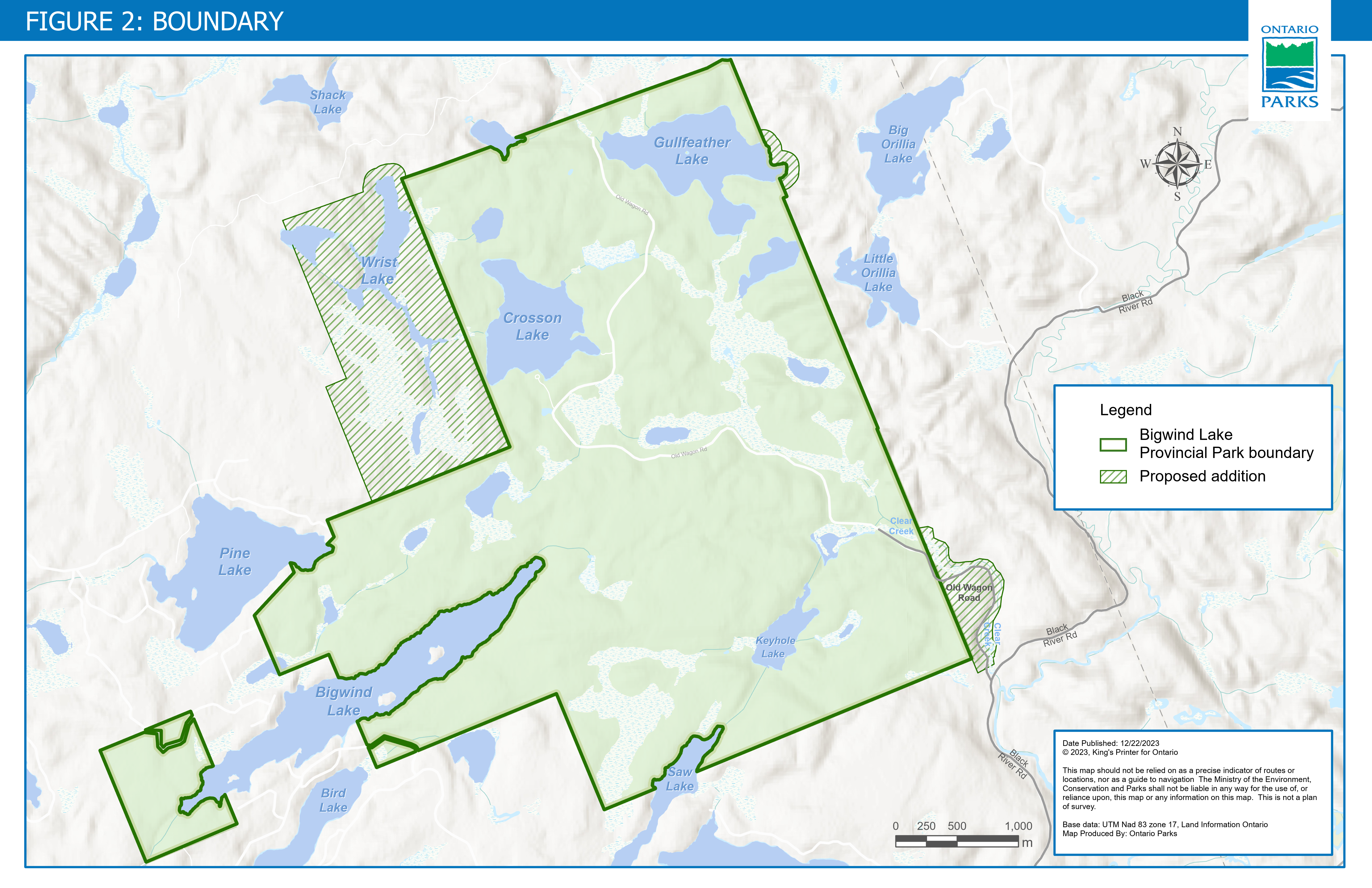
Figure 2 is a map showing the boundary of Bigwind Lake Provincial Park and some proposed additions to the boundary northwest, northeast and southeast of the park.
1.2.1 Proposed park boundary expansion
Ontario proposed to expand the boundary of Bigwind Lake Provincial Park to add approximately 314 hectares of Crown land, including:
- 274 hectares of land northwest of the park, which includes Wrist Lake, and extensive conifer (i.e. evergreen) forests and wetlands
- 6 hectares of land to include shoreline on the east side of Gullfeather Lake
- 34 hectares of land southeast of the park to include portions of Old Wagon Road, Clear Creek and a rare stand of red spruce trees
This proposed park boundary expansion would provide long-term protection, increase landscape connectivity
Zoning and site-specific policies presented in the management plan for the proposed additions would only take effect if the areas are regulated under the Provincial Parks and Conservation Reserves Act, 2006.
MECP supports the acquisition of land through sale or donation to enhance protection or park management. Adjacent lands with similar values, would be of highest priority. If land is offered for sale or donation, it will be evaluated for its potential contribution to park objectives. The acquisition of suitable properties would be subject to the availability of financial and human resources.
1.2.2 Adjacent land to the park
Bigwind Lake Provincial Park is surrounded by a combination of Crown land, managed by the Ministry of Natural Resources (MNR), and private land. Large areas of private lands are found to the south and east of the park, including cottage lots adjacent to the park on Bigwind, Pine and Bird Lakes. Private land is not included within the park boundary and as such park policy does not apply to these areas.
1.3 Indigenous communities and traditional territories
Indigenous communities have lived on and relied upon the lands and waters within their traditional territories and treaty areas long before Bigwind Lake Provincial Park was established in 1985, and they continue to rely on these lands and waters to exercise their constitutionally protected Aboriginal and treaty rights which includes various practices, customs, and traditions integral to Indigenous communities’ distinctive cultures and ways of life. Some examples of these practices, customs and traditions may include hunting, trapping, fishing, and gathering food for personal, social and ceremonial purposes; traditional teachings; and ceremonial and spiritual activities.
Bigwind Lake Provincial Park is located within:
- the traditional territories of some of the Chippewa and Mississauga Nations that are signatory to the Williams Treaties (1923)
- the traditional territories of several First Nation signatories to the Robinson Huron Treaty of 1850
- the traditional lands of Nation Wendat
- the Métis Nation of Ontario’s asserted Georgian Bay Métis Harvesting Area
The park is also near historic and contemporary Métis communities, including the Historic Georgian Bay Métis community, whose members are citizens of the Métis Nation of Ontario.
Many Aboriginal and treaty rights are connected to the natural environment and are primarily exercised on Crown lands in Ontario, including within provincial parks and conservation reserves. Ontario is committed to meeting its constitutional obligations that may be owed to Indigenous communities, including the duty to consult.
Further, Ontario Parks is working to rebuild and renew relationships with Indigenous peoples grounded in principles of trust and respect. The aim is to seek opportunities to protect, study and enjoy provincial parks and conservation reserves together alongside Indigenous communities.
1.4 Name of the park
Bigwind Lake Provincial Park is named after Bigwind Lake. The lake is believed to be named after Chief Bigwind from the Chippewas of Rama First Nation.
The regulated boundary of the park includes a portion of the Bigwind Lake shoreline and does not include the lake itself. There is no authorized public access from Bigwind Lake into the park.
1.5 Ecological integrity
The Provincial Parks and Conservation Reserves Act, 2006 states that the maintenance of ecological integrity shall be the first priority and the restoration of ecological integrity shall be considered in all aspects of the planning and management of Ontario’s system of provincial parks.
Ecological integrity is a concept that addresses three ecosystem attributes – composition, structure and function. This concept is based on the idea that the composition and structure of the protected area should be characteristic for the region and that ecosystem functions should proceed normally.
The identification of values and pressures on those values, and an analysis to determine appropriate actions and priorities to address those pressures, is considered the basis for maintaining and enhancing ecological integrity.
1.6 Social and economic benefits
Provincial parks can bring a positive social and economic benefit to local communities.
The local economy will benefit from park visitor-associated spending in local communities, on items like groceries, supplies, restaurant meals, fuel and entry to tourism attractions. If campgrounds are developed in the future, local communities would also experience increased employment opportunities year-round.
2. Park classification
Ontario’s provincial parks are classified into categories based on how they contribute to meeting the objectives of the provincial park system (section 3.3). Park classification defines a park’s role in providing opportunities for environmental protection, recreation, heritage appreciation and/or science, and determines the type and extent of activities that may take place in a park.
Bigwind Lake Provincial Park is a natural environment class park. Natural environment class parks protect outstanding recreational landscapes, representative ecosystems and provincially significant elements of Ontario’s natural and cultural heritage and provide high-quality outdoor recreational and educational experiences.
3. Park purpose, vision and objectives
3.1 Purpose
The purpose of Bigwind Lake Provincial Park is:
To protect the park’s natural and cultural environment, and maintain landscape connectivity
3.2 Vision
The vision for Bigwind Lake Provincial Park is:
A modern, four-season destination that offers a variety of unique recreational and educational opportunities for visitors, while protecting the natural and cultural environment and maintaining large undisturbed areas for wildlife and species at risk.
3.3 Objectives
Management of Bigwind Lake Provincial Park will be consistent with the four objectives for provincial parks, as described in the Provincial Parks and Conservation Reserves Act, 2006:
- To permanently protect representative ecosystems, biodiversity and provincially significant elements of Ontario's natural and cultural heritage and to manage these areas to ensure that ecological integrity is maintained.
- To provide opportunities for ecologically sustainable outdoor recreation opportunities and encourage associated economic benefits.
- To provide opportunities for residents of Ontario and visitors to increase their knowledge and appreciation of Ontario's natural and cultural heritage.
- To facilitate scientific research and to provide points of reference to support monitoring of ecological change on the broader landscape.
4. Key park values
4.1 Natural heritage
4.1.1 Life science
Bigwind Lake Provincial Park is situated in Ecodistrict 5E-8 and contains representative examples of Algonquin Dome-influenced wildlife, forest and wetland habitats. The park forests are dominated by mature (100- to 130-year-old) Sugar Maple, Yellow Birch, American Beech, Eastern Hemlock and Eastern White Pine, all growing atop rugged, acidic, granitic gneiss soils. Beneath this canopy thrives a rich diversity of spring ephemeral wildflowers, ferns, mosses and lichens. Park wetlands exhibit a variety of compositions and structure – water flow is slow and often beaver-influenced. Wetland habitat types include poor fens, sedge meadows, thicket swamps and Black Spruce-dominated kettle bogs. Lakes in the park are cool, deep and oligotrophic, with narrow sand/gravel or peaty emergent shores (Brunton 1993; LeGros 2018).
Over 230 species of vascular plants, 27 bryophytes (mosses and liverworts) and 65 lichens have been recorded in the park. These include the above-mentioned species as well as a disjunct population of Red Spruce (iNaturalist), Swamp Moonwort, Smaller Fern Moss, lungwort and carnivorous species, such as sundews, bladderworts and Pitcher Plant (LeGros 2018; NHIC 2023b; Olar 2023). Due to the diversity of wetland habitats and challenges with accessing areas of the park, there is likely a high number of unidentified plant species.
The park supports 16 species of amphibians and nine species of reptile, such as Smooth Green Snake, Midland Painted Turtle, Gray Treefrog and Red-Spotted Newt (LeGros 2018; Olar 2023). Many of these species are dependent on the park’s permanent wetlands and ephemeral woodland pools.
Ninety (90) species of bird have been observed in the park with 62 species displaying evidence of breeding in the park. Wood warblers such as Blackburnian Warbler, Common Yellowthroat and Ovenbird are abundant during breeding season and are accompanied by less common species such as Canada warbler, Eastern Wood-pewee and Pileated Woodpecker. Park lakes and rivers support Common Loon, Common Merganser, a breeding colony of American Herring Gulls and a small heronry of Great Blue Herons (LeGros 2018; NHIC 2023a; Olar 2023).
Fifteen (15) species of fish have been found in park waters, including Rainbow Trout, Lake Trout, Yellow Perch, White Sucker, Creek Chub, Pumpkinseed Sunfish, Northern Redbelly Dace, Brown Bullhead, and both large and smallmouth bass (GeoProcess Research Associates Inc. 2023; LeGros 2018). There is likely a greater diversity of fish species yet to be identified in the park. See section 7.1.1 for more information on fisheries within the park.
Preliminary investigations of invertebrate and fungi diversity suggest the park has diverse and abundant moth, butterfly and dragonfly populations, including populations of bog copper butterflies. The provincially rare, Spike-lip Crater (snail) has also been observed within the park near Bigwind Lake (iNaturalist; NHIC 2023a; Olar 2023). The park’s relatively intact forest soil appears to support an abundance of mycorrhizal and saprotrophic fungi, but a detailed inventory has not been undertaken.
Twenty-eight (28) species of mammals have been observed within the park, including Little Brown Myotis (bat), beaver and Algonquin Wolf. Critical winter habitat for deer and Moose have been identified within the park (LeGros 2018; Olar 2023).
Between 2014 and 2016, the MNR conducted an extensive Algonquin Wolf monitoring program. Temporary GPS tracking collars were attached to Algonquin Wolves in and adjacent to Algonquin, Kawartha Highlands and Queen Elizabeth II Wildlands provincial parks. The home ranges and seasonal movements of these rare and threatened animals were remotely monitored to better understand how they use the landscape. MNR recorded Algonquin Wolves travelling through Bigwind Lake Provincial Park.
Significant wildlife habitat and landscape connectivity has been mapped within the park (Bowman and Cordes 2015; Olar 2023). The science of landscape connectivity involves mapping the potential routes that wildlife travel to access food, water, shelter and breeding habitat based on topography and ecosystem types. Understanding how Bigwind Lake Provincial Park fits within the greater landscape and how species use the park provides a perspective on the park’s ecological value within the region.
Areas in the park with higher connectivity value (Figure 3) contribute to a landscape-level connectivity corridor for many species and provide important habitat for species including the Algonquin Wolf and Moose. Connectivity corridors also help to facilitate shifts in the ranges of plants, animals and natural communities as they adapt to climate change.
To date, 15 species at risk have been found in Bigwind Lake Provincial Park. See section 7.1.4 for more information.

Figure 3 is a map showing areas that have low to high landscape connectivity value in the park and the surrounding area. The area within the park with the highest connectivity value is between the east end of Bigwind Lake and the area south of Crosson Lake. Large areas of the park have moderate to high connectivity value.
Landscape connectivity looks at how features on the ground impact the movement of species across their region. Figure 3 illustrates the degree of connectivity in different areas of the park. Areas with higher connectivity values are important corridors for wildlife to safely travel, and access food, water, shelter and breeding habitat. These corridors are identified based on topography and ecosystem types.
4.1.2 Earth science
Earth science features of Bigwind Lake Provincial Park are considered locally significant and include representation of gneisses of the Opeongo Domain of the Algonquin terrain (Easton 1992). These gneisses have been described as granitized, banded, pink and grey rock (Lawrence 1973).
The topography of the park is characterized by a knobby, hummocky and undulating to rolling landscape. The bedrock is cut by one regional fault through the Saw Lake and Keyhole Lake area creating valley-like features (GHD 2023b). Indications of glacial action include glacial polish and depositional features, such as the bouldery-sandy till which thinly mantles the hills. Boulder trains are found at the mouths of the valleys and a small area of outwash deposits is found at the south end of the park (Lawrence 1973).
4.2 Cultural heritage
Simply defined, our heritage is everything that we value and want to preserve for future generations. Cultural heritage is the portion of our heritage that retains the evidence of human activity.
Bigwind Lake Provincial Park has a rich and varied history of use. With occupation of the area beginning in the late Paleolithic period approximately 10,000 years ago, the area encompasses a chronology of Indigenous and Euro-Canadian histories (ARA 2023).
The park lies within the treaty, traditional and/or ancestral territories of numerous Indigenous peoples and communities (section 1.3). As such, it has been identified as both a historical and current harvesting site (ARA 2023).
A Stage 1 Archaeological Assessment was completed in 2023 which provided baseline information about the Indigenous and settler history of this landscape and known cultural heritage values in the park.
The Stage 1 Archaeological Assessment Report (ARA 2023) identified the following historical information:
- Chief Bigwind, a Chief of the Chippewas of Rama First Nation, used the area to harvest moose and deer for his family and community.
- The area also fell within the traditional hunting territory of Thomas Port of the Chippewas of Rama First Nation and was a noted Chippewa Travel Corridor to Lake Couchiching.
- A portage trail between Saw (previously named Mud) Lake and Keyhole (previously named Beaver) Lake is noted on the 1861 Plan of Oakley.
- Mickle Dyment & Co. operated a camp on the west side of Crosson (previously named North) Lake from 1900 to 1904. It included a sleep cabin, cookery, stable, office and blacksmith shop. The camp was removed after it was abandoned, although some remnants remain. Mickle Dyment & Co. logged the area until 1938.
- Mickle Dyment & Co. operated log slides along the streams leading into the Black River, utilizing Crosson Lake, Gullfeather (previously named Gull) Lake or Keyhole Lake.
- Logging ceased around the park until the Boyes Brothers began operations in the late 1950s until 1964, a year before Bigwind Lake Reserve was created. No structures were built in the area that is now the provincial park, except a possible tote road from Saw Lake to Keyhole Lake.
A Stage 2 Archaeological Assessment was conducted in 2024. See section 7.1.7 for information on the management of cultural heritage values.
A reconnaissance inventory of cultural resources was conducted for the park in the early 1970s (Stevens 1973). It primarily examined the remnants of built heritage and historical landscapes related to the intense logging that once took place, including remnant logging dams, camps, roads and a sawmill.
The remnants of a Junior Ranger Camp operated by the Ministry of Natural Resources (MNR) can be found on the south shore of Crosson Lake. The camp was active from at least 1969 to 1987, during which time, hundreds of youth were employed and actively engaged in resource management activities in the surrounding area and local communities (ARA 2023).
5. Potential pressures on park values
The protection of Bigwind Lake Provincial Park’s natural and cultural values is a priority. During the management planning process, pressures on park values are identified and policies are developed to prevent, minimize or adapt to the effects.
Potential pressures identified in the park include:
- unauthorized activities, such as all-terrain vehicle use and power boat use
- unauthorized trail and campsite creation in sensitive habitats
- introduction of invasive species, such as plants, forest pests and wildlife diseases (e.g. phragmites, knotweed, Dog Strangling Vine, Hemlock Woolly Adelgid, Emerald Ash Borer, snake fungal disease)
- climate change effects, such as extreme storms, floods, droughts and shifting seasons
- effects while creating park facilities, such as increased road mortality for some species, species habitat loss and fragmentation, increased light and noise pollution, and wildlife habituation (i.e. animals losing their natural fear of humans)
6. Zoning
Zones are established in provincial parks to guide policy and management decisions based on the sensitivity of natural and cultural values, potential for recreational uses and desired amenities. Distinct policies are applied to each zone to ensure park values are protected, and educational and recreational opportunities are provided sustainably.
Bigwind Lake Provincial Park has four types of zones: access, development, natural environment and nature reserve. These zones are shown in Figure 4 and are described below. Digital map improvements have resulted in some variation between the regulated area under the PPCRA and the total area of the zones calculated for the management plan.
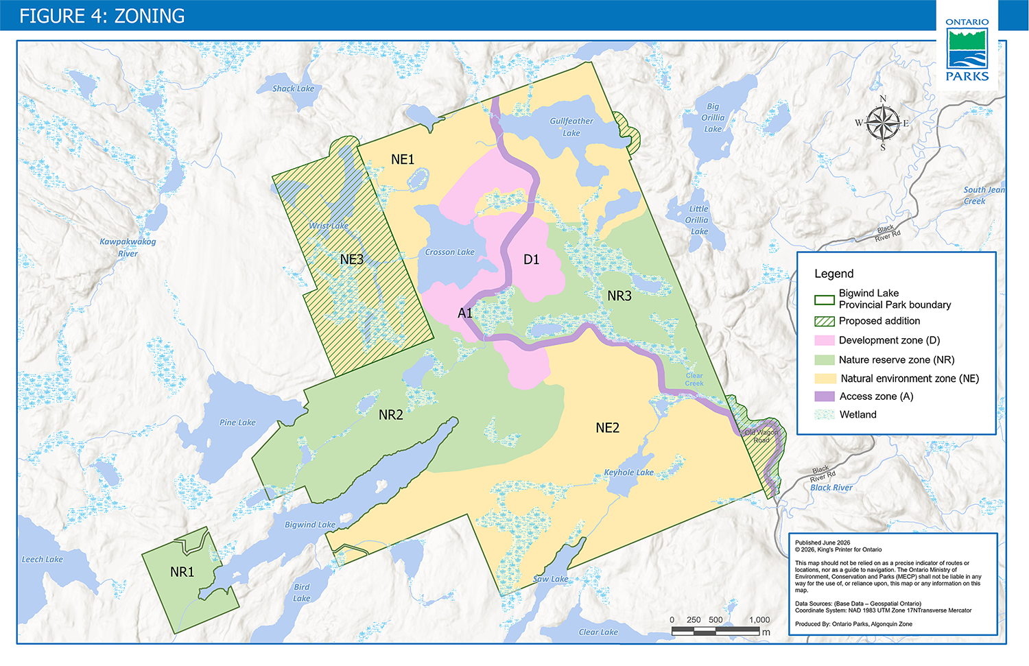
Figure 4 is a map showing zoning areas for the existing provincial park and the proposed additions to the park boundary. There is one development zone, three nature reserve zones, three natural environment zones and one access zone.
6.1 Access zones
Access zones provide the main access to park facilities and services.
A1: Access (69 ha)
Description:
A1 encompasses the main access road, Old Wagon Road, starting at the park entrance at the southeast corner of the park and ending near Gullfeather Lake. A1 will be approximately 80-metres wide, and may also include a multi-use, accessible trail adjacent to Old Wagon Road, as resources permit, and utilities and other services, if needed to support park operations. A portion of the Ontario Federation of Snowmobile Clubs (OFSC) trail will be in this zone. Some of the proposed park addition would also be included in A1.
Management intent:
This zone is intended to provide access to park and recreational opportunities. Portions of A1 will be used for snowmobiling in the winter.
6.2 Development zones
Development zones provide park facilities and services for a wide range of day use and camping activities. They should constitute a relatively small portion of the park.
D1: Development (158 ha)
Description:
D1 is located near the centre of the park, around the east side of Crosson Lake and on both sides of Old Wagon Road (A1).
Management intent:
This zone is intended for day-use areas and associated infrastructure. A wide variety of visitor services and park facilities, such as campgrounds, washrooms, and administrative and maintenance areas, may be added in the future, as resources permit.
6.3 Nature reserve zones
Nature reserve zones include natural and cultural values which require management distinct from that in adjacent zones. Trails, interpretive signs and other minimal infrastructure may be permitted. Campsites are not permitted in nature reserve zones.
Three nature reserve zones are proposed to protect sensitive species and habitat, with a focus on landscape connectivity and large core areas with minimal disturbance for wildlife.
NR1: West nature reserve (71 ha)
Description:
NR1 encompasses the provincial park area on the west end of Bigwind Lake to the water’s edge. This zone is dominated by upland forest species, including Sugar Maple, American Beech and Eastern White pine. This small area has been identified as important habitat for terrestrial wildlife moving between the adjacent network of cottage lakes. The site’s mature forests also provide a thermal refuge
Management intent:
To conserve and monitor the site’s integrity as a wildlife corridor and thermal refuge, this zone is intended to be managed primarily for research and monitoring. Unlike the other nature reserve zones, trails are not permitted in NR1. This trail-free area will contribute to the nature reserve zone connectivity corridor by providing an undisturbed area for wildlife.
NR2: Central nature reserve (387 ha)
Description:
NR2 spans a large area on the west side of the park dominated by extensive tracts of mature deciduous and evergreen forests. Upland and lowland forest species present include Sugar Maple, Yellow Birch, Eastern Hemlock and Balsam Fir, as well as Pink Lady Slipper, Hobblebush and a wide diversity of wood ferns.
This large area encompasses the majority of critical habitat used by terrestrial wildlife as they move within and through the park. Additionally, the mature forests provide a thermal refuge for large mammals from the physical stress of extreme heat during summer months. The size of this nature reserve also offers shelter to reclusive wildlife, such as Algonquin Wolf.
NR2 also contains some smaller waterbodies, and portions of the shorelines of Bigwind and Pine Lakes. Protecting these shorelines allow natural processes to occur without impacts created by significant human activity – acting to maintain lake health while providing a sanctuary for nesting waterbirds and young fish.
A portion of an existing OFSC trail is within NR2.
Management intent:
This zone is intended for research and monitoring, nature appreciation, and low-intensity recreational opportunities, such as hiking and cross-country skiing. To protect ecological values, specifically the site’s integrity as a wildlife corridor and thermal refuge, trails will be routed to minimize disturbance to wildlife.
Snowmobiling is permitted on the OFSC trail in NR2.
NR3: East nature reserve (285 ha)
Description:
Dominated by a vast mosaic of wetlands, NR3 protects nearly the full reach of Clear Creek including the eastern lands that water it. These wetlands provide critical breeding and foraging habitat for a wide diversity of birds, reptiles and amphibians, and protects much of the identified Blanding’s Turtle habitat within the park. These wetlands have proven to be an important hunting location for the six species of bats confirmed in the park (two species are classified as endangered under the Species Conservation Act, 2025). The cool waters flowing through this nature reserve zone also offer thermal refuge and an important summer feeding ground for Moose.
The zone would also include a small portion of the proposed addition east of Old Wagon Road, which contains Clear Creek.
Management intent:
To conserve and monitor the site’s integrity as a wildlife corridor and thermal refuge, this zone is intended for research and monitoring. It also offers opportunities for nature appreciation and low-intensity recreational activities, such as hiking and cross-country skiing. Trails will be routed to minimize disturbance to wildlife.
6.4 Natural environment zones
Natural environment zones include natural, cultural and aesthetic landscapes in which minor infrastructure, such as backcountry campsites, trails and minimal interpretive facilities, may be permitted to support recreational activities.
NE1: North natural environment (429 ha)
Description:
NE1 includes the natural environment in the north end of the park. It includes Crosson Lake, Gullfeather Lake and an un-named lake south of Gullfeather Lake. The zone would also include the proposed addition on the east side of Gullfeather Lake if it is added to the park.
NE1 is primarily forested upland communities of maple hardwood and hemlock-cedar conifer, peppered with meadow marsh and conifer swamps. The understory of this zone is diverse and includes many species of ephemeral wildflowers, including trilliums, Trout Lily and Spring Beauty.
Management intent:
This zone is intended to provide opportunities for nature appreciation and recreational activities, such as hiking, paddling, cross-country skiing and backcountry camping.
NE2: South natural environment (628 ha)
Description:
NE2 spans the southern area of the park. It includes Keyhole Lake, portions of the shorelines of Bigwind and Saw Lakes, and many smaller waterbodies. The zone would also include a small portion of the proposed addition west of Old Wagon Road.
NE2 is dominated by sugar maple mixed with American Beech, Yellow Birch, White Pine, Basswood, Red Oak and White Spruce. Other common forest species found in this zone include Starflower, Goldenthread, Bunchberry and a variety of ferns. NE2 includes scattered areas of organic rich conifer swamps where White Spruce, Balsam Fir, Eastern White Cedar, Pink Lady Slipper, Sphagnum Moss and the few remaining Black Ash can be found.
A portion of an existing Ontario Federation of Snowmobile Clubs trail is within NE2. There is also a private recreation camp under a land use permit in this zone. See section 7.1.8 for more information.
A private road runs through the southwest corner of NE2 and is not part of the park.
Management intent:
This zone is intended to provide opportunities for nature appreciation and recreational activities, such as hiking and backcountry camping. Snowmobiling is permitted on the OFSC trail in NE2.
NE3: Wrist Lake natural environment (274 ha)
Description:
NE3 encompasses the proposed addition northwest of the park.
It contains Wrist Lake and other smaller waterbodies. NE3 is dominated by hemlock-cedar evergreen forests and an extensive wetland complex. The drier uplands in the north support communities of maple and birch deciduous forest, peppered with mature White Pines. The understory of this zone is diverse, and includes many species of ephemeral wildflowers, including trilliums, Trout Lily and Spring Beauty.
Management intent:
NE3 is proposed with the intention to permit hunting to continue in this area if it is added to the park (see section 7.1.2.2 for more information on hunting).
This zone is also intended to provide opportunities for nature appreciation and recreational activities, such as hiking cross-country skiing and backcountry camping.
7. Policies
7.1 Resource management policies
7.1.1 Fisheries
A total of 15 species of fish have been identified in Bigwind Lake Provincial Park (section 4.1.1).
Crosson Lake was historically stocked by the Ministry of Natural Resources (MNR) with Walleye (1939 and 1942), Brook Trout (1964, 1966 and 1983), Rainbow Trout (1981-2007) and Lake Trout (1972). While survey work in 2023 did not detect these species, surveys in 2005 and discussions with anglers suggest the Rainbow Trout and Lake Trout may still be present in Crosson Lake, but in very low numbers. It is possible the Lake Trout population may be a native remnant population – mixed with stocked material – but detailed genetic work on remaining individuals would be needed to confirm this.
7.1.1.1 Fisheries management
Fisheries will be managed consistent with MNR’s Fisheries Management Zone (FMZ) 15.
Ontario Parks will work collaboratively with MNR, interested Indigenous communities and researchers to maintain and enhance native self-sustaining fish populations in the park.
Stocking will be considered to enhance recreational fishing opportunities or aquatic ecosystem restoration where ecologically appropriate.
Should remnant native populations of Brook Trout or Lake Trout be confirmed in lakes within the park, Ontario Parks may undertake a conservation and restoration program in collaboration with MNR and interested Indigenous communities.
7.1.1.2 Sport fishing
Sport fishing is permitted in the park subject to regulations for FMZ 15 as described in the Ontario Fishing Regulations Summary.
Largemouth bass, yellow perch and pumpkinseed sunfish are the primary sport fishing species confirmed within the lakes of Bigwind Lake Provincial Park.
7.1.1.3 Commercial bait harvesting
There are two commercial bait harvest areas that encompass the park (PS-0245 and PS-0246). These licences are managed by MNR. Existing commercial bait harvesting operations may continue and active licences may be transferred.
If in future an application is made by a current licence holder to transfer their licence, the park’s nature reserve zones would be removed from the area of the new licence.
New commercial bait harvesting operations will not be permitted.
7.1.2 Wildlife
7.1.2.1 Wildlife and habitat management
Projects to maintain, enhance, rehabilitate or restore native wildlife habitat (e.g. turtle nesting habitat, snake hibernacula, fish spawning shoals), and to protect species and habitat against the effects of climate change, will be implemented if feasible and appropriate.
Animal populations or individual animals may be managed as necessary to ensure:
- human health and safety
- the health of the species
- park values are protected
- ecological integrity is maintained
7.1.2.2 Sport hunting
Sport hunting is not permitted in Bigwind Lake Provincial Park.
If the proposed boundary additions to the park are regulated under the Provincial Parks and Conservation Reserves Act, 2006(PPCRA), MECP will request that MNR propose an amendment to Ontario Regulation 663/98: Area Descriptions (O. Reg. 663/98) under the Fish and Wildlife Conservation Act, 1997 (FWCA) to allow hunting to continue in NE3.
7.1.2.3 Bear management areas
Bear management areas (BMAs) are areas of Crown land used by tourist operators licenced by MNR to provide black bear hunting services. The park is located within a licenced BMA (BR53-02); however, hunting is not permitted in the park.
The proposed boundary additions to the park are also located within this BMA. If future amendments are proposed by MNR to FWCA O. Reg. 663/98 to permit hunting to continue in NE3, BMA operations would also be permitted to continue in NE3 (section 7.1.2.2).
No new BMAs will be permitted in the park.
7.1.2.4 Commercial fur harvesting
A registered trapline (BR-06) covers most of the park, and a trapper’s cabin is located on the southern shore of Gullfeather Lake. This licence is managed by MNR.
The existing commercial fur harvesting operation may continue in the park. If in future an application is made by the current licence holder to transfer their licence, Bigwind Lake Provincial Park lands would be removed from the area of the new licence.
If in future a campground is added to the park, the existing commercial fur harvesting operation would no longer be permitted to continue in the park. New commercial fur harvesting operations will not be permitted in the park.
7.1.3 Vegetation management
Vegetation management will be focused on promoting the health and diversity of native vegetation communities and the park’s ecological integrity.
Projects to enhance or restore native vegetation will be implemented, if feasible and appropriate. Extirpated native species may be reintroduced if biologically feasible and desirable for perpetuating park values, using seed stocks native to the park or surrounding area if possible.
To protect the values associated with the river habitats found within the park, special consideration is necessary when vegetation management occurs within 30 metres of a river’s edge. Best management practices for maintaining and, where feasible, enhancing vegetation cover within this buffer will be considered.
Trees will be removed if they pose a risk to human safety or infrastructure, or if necessary to support recreational opportunities.
Pesticides (e.g. herbicides, fungicides, insecticides) may be used to maintain ecological integrity or ensure public health and safety. Whenever possible, biological and mechanical controls will be given preference over the use of chemicals.
7.1.4 Species at risk and rare species
Fifteen (15) species identified as special concern, threatened or endangered on the Committee on the Status of Species at Risk in Ontario (COSSARO) list have been found in the park, including:
- Black Ash (endangered)
- Butternut (endangered)
- Little Brown Myotis (bat; endangered)
- Northern Myotis (bat; endangered)
- Algonquin (Eastern) Wolf (threatened)
- Blanding’s Turtle (threatened)
- Chimney Swift (threatened)
- Canada Warbler (threatened)
- Common Nighthawk (special concern)
- Eastern Wood-pewee (special concern)
- Evening Grosbeak (special concern)
- Olive-sided Flycatcher (special concern)
- Snapping Turtle (special concern)
- West Virginia White (butterfly; special concern)
- Wood Thrush (threatened)
Species at risk and their habitats will be protected in a manner consistent with legislation (e.g. Species Conservation Act, 2025(SCA), Species at Risk Act), regulations and guidelines, and other relevant policy or best practices.
Ontario Parks may undertake management actions for species at risk and rare species, as supported by research and directed through recovery strategies, government response statements or other species-specific management plans.
7.1.5 Alien and invasive species
In 2023, 27 alien or invasive species were recorded in the park during plant surveys and other on-site assessments.
Alien species are plants, animals and microorganisms introduced by human actions outside their natural past or present distribution. These species may originate from other continents, countries or provinces, or from other parts of Ontario.
Invasive species are alien species that are harming, or likely to harm, the natural environment.
The following alien and invasive species have been found within, or near, the park:
- Common Reed (phragmites)
- Rusty Crayfish
- Emerald Ash Borer (beetle)
- Orange Daylily
- Tufted Vetch
- Common St. John’s Wort
- Ox-eye Daisy
- Common Mullein
Where possible, efforts will be taken to control or eradicate invasive species in Bigwind Lake Provincial Park. Invasive species management will aim to reduce or prevent impacts to native species, biodiversity, ecosystem function and recreational opportunities.
7.1.6 Fire management
Fire management in provincial parks is guided by the Fire Management Policy for Provincial Parks and Conservation Reserves (MECP and MNDMNRF 2021).
The goal of fire management in provincial parks is to protect public safety and promote and encourage the use of fire as a natural ecological process for the maintenance and restoration of ecological integrity.
Bigwind Lake Provincial Park is located within the Northeast Fire Region as identified in MNR’s Wildland Fire Management Strategy (2014b). An assets, resources and opportunities map will be developed to provide guidance when responding to wildland fires in the park.
Prescribed burning may be utilized as a resource management tool. Prescribed burning is the deliberate, planned and knowledgeable application of fire by authorized personnel to achieve ecological or hazard reduction objectives.
7.1.7 Cultural heritage management
Cultural heritage values will be assessed and managed in accordance with the Ontario Heritage Act (OHA), and other applicable legislation and policies. See section 4.2 for information on the park’s cultural heritage values.
Ontario Parks will work with Indigenous communities on matters related to identifying, mapping and managing Indigenous values, sites and artifacts within the park. Ontario Parks is committed to meeting its constitutional obligations that may be owed to Indigenous communities and working to rebuild and renew relationships with Indigenous peoples. See section 1.3 for more information.
The remnants of the former Junior Ranger Camp in D1 will be retained and may be restored or adapted for the park’s education and heritage appreciation programming.
7.1.8 Land management
This section presents policy for authorizations to use or occupy land in the park for private, commercial, or other uses that are not for park purposes.
An existing private recreation camp located on the south side of Bigwind Lake is permitted under a land use permit. Access to the recreation camp is via a trail off of Bigwind Lake Road at the west end of NE2 (this trail is also used by the OFSC). No new private recreation camps are permitted in the park.
There are currently four licences for commercial resource activities that overlap the park boundary. See sections 7.1.1.3, 7.1.2.3 and 7.1.2.4 for more information.
Authorizations or permits may be issued to the above permit and licence holders for activities, such as building maintenance, trail maintenance and all-terrain vehicles (ATV) use for access purposes.
7.1.8.1 Snowmobile trail
The Ontario Federation of Snowmobile Clubs (OFSC) trail in the park will retain its connection to the Trans Ontario Provincial (TOP) B Trail network. Ontario Parks will continue to engage with the OFSC, the local club and interested partners to explore potential trail and water crossing improvements to resume snowmobile use on the B Trail south of Bigwind Lake.
The OFSC has a land use permit for two bridges in the park, one on Old Wagon Road near Crosson Lake and another on the west end of NE2 along the B Trail. Ontario Parks may issue additional authorizations and permits to the OFSC for water crossings, minor reroutes and trail maintenance in the park.
Snowmobile trails are not permitted in nature reserve zones within the park, except for the portion of the existing snowmobile trail within NR2.
7.1.9 Water management
Bigwind Lake Provincial Park is located on the divide of the Muskoka River (02EB) and the Severn River-Lake Simcoe (02EC) watersheds. Crosson, Gullfeather and Saw Lakes are in the Severn River-Lake Simcoe watershed.
Two weirs
Sustaining high quality water resources is fundamental to the protection of the park and adjacent land features and values.
7.1.10 Science and research
Any government agency or external party who wishes to carry out research in the park must obtain a research authorization letter from Ontario Parks. Researchers may also need to obtain additional permits or approvals.
Research activities and facilities should be compatible with protection and/or recreational values in the park and subject to policies associated with the park's classification, unless otherwise authorized by Ontario Parks. Conditions will be detailed within written agreements and/or land use permits including maintenance and decommissioning responsibilities.
Ontario Parks is interested in research and monitoring on the following themes for Bigwind Lake Provincial Park:
- Landscape connectivity: Effectiveness of modelling and the park’s nature reserve zone corridor.
- Long-term monitoring to evaluate the effectiveness of mitigation measures implemented during the creation of the operating provincial park.
- Ecological processes and the health of wetland ecosystems.
- Economic value of park benefits (e.g. human health benefits of nature, ecosystem service valuation).
- Effects of climate change on biotic communities.
- Influence of hyperabundant native species on ecosystem health and species diversity.
- Invasive species monitoring tracking presence, spread and removal efforts (e.g. Hemlock Woolly Adelgid).
- Long-term monitoring to track:
- bird populations and breeding activity
- Algonquin Wolf populations and habitat usage
- Potential impact of recreational uses (e.g. trails, camping, fishing) on ecological integrity, and effectiveness of mitigation measures.
- Species at risk monitoring, including examinations of habitat change.
- Wildlife tracking to help track population changes within the park and guide future management decisions.
7.2 Outdoor recreation management policies
Bigwind Lake Provincial Park will provide many opportunities for outdoor recreational activities, such as backcountry camping, hiking, swimming, paddling, bicycling, cross-country skiing, snowshoeing, and snowmobiling.
Additional camping opportunities may be offered in the future, such as:
- tent, trailer and recreational vehicle (RV) camping
- roofed accommodations
- walk-in camping
Hiking, bicycling, cross-country skiing and snowshoeing are permitted on designated trails. Snowmobiling is only permitted on the OFSC trail. See section 7.3.2.5 for more information on trails.
Opportunities for swimming and paddling (e.g. swimming docks, canoe and kayak rentals) will be offered in the park’s day-use areas. See section 7.3.2.4 for more information.
Horseback riding and aircraft landing are not permitted in the park. Power boats are not permitted on lakes fully enclosed within the park boundary (e.g. Crosson Lake, Gullfeather Lake, Keyhole Lake). ATV use is not permitted in the park, except by persons who have occupational authority in the park that permits this form of access (e.g. recreation camp land use permit holder) and/or by persons with written permission from the park superintendent.
For policies on sport fishing and sport hunting, see sections 7.1.1.2 and 7.1.2.2.
7.3 Park operations and development policies
7.3.1 Accessibility
Ontario Parks will develop and implement accessible infrastructure and services, creating a more inclusive and equitable outdoor experience for everyone.
7.3.2 Infrastructure
Infrastructure and facilities may be removed, maintained, repaired, upgraded or replaced as required.
7.3.2.1 Access, roads and parking
Old Wagon Road will continue to provide the primary access into the park at the southeast corner via Highway 118 and Black River Road. Park access will not be provided on the north side of the park, except for snowmobilers on the OFSC trail.
Old Wagon Road will be upgraded to Crosson Lake and a new parking area will be developed to provide improved access to recreational opportunities. Some portions of Old Wagon Road may require minor rerouting.
Additional roads, water crossings and parking areas may be developed in the future if necessary to support visitor demand or additional park facilities (e.g. campgrounds, day-use areas).
Measures to reduce road mortality for wildlife, such as reptiles and amphibians, will be installed where needed (e.g. bridges, eco-passages, exclusion fencing). Innovative techniques focused on ecological integrity, connectivity and species protection will be prioritized.
7.3.2.2 Campgrounds
Campgrounds may be developed in D1 in the future, as resources permit, and may include:
- car, trailer and RV campsites
- walk-in campsites
- roofed accommodations
Washrooms, showers, dishwashing and laundry facilities, and other infrastructure may be developed to support any future campgrounds.
7.3.2.3 Backcountry campsites
Approximately 10 backcountry campsites will be developed on Crosson Lake. Additional backcountry campsites may be developed throughout the park. No backcountry campsites will be developed along the shoreline of Bigwind Lake.
Backcountry campsites may be relocated, if necessary, to protect natural or cultural values. Backcountry campsites are not permitted in nature reserve zones.
7.3.2.4 Day-use areas
A day-use area will be developed in D1 on the southeast side of Crosson Lake. It will include a parking area, a vault privy and an accessible pathway to the water.
Additional day-use areas may be added in D1 and A1 (e.g. west of Gullfeather Lake) in the future, as resources permit, and may offer amenities, such as docks, equipment rentals, picnic shelters, playgrounds, pet exercise areas, washroom facilities and parking.
7.3.2.5 Trails
A trail will provide a hiking and bicycling route from the Crosson Lake day-use area to Gullfeather Lake. The trail will follow a rustic portion of Old Wagon Road in A1 and is utilized by snowmobiles in the winter.
A trail network may be developed in the future, and may include:
- a trail around Crosson Lake
- a trail to Keyhole and Saw Lakes
- trail and water crossing improvements, including potential realignment, on the OFSC B Trail south of Bigwind Lake
- an accessible trail adjacent to Old Wagon Road
- walking trails throughout the campgrounds to connect campsites to various park facilities
- hiking, cross-country ski and snowshoeing trails
- portage trails to provide access to lakes with canoe-in backcountry campsites (section 7.3.2.3)
- a natural “active trail” with introduced challenges and obstacles that fit into the surrounding environment and promote exercise, movement and creativity
Existing trails and portages will be assessed and may be incorporated into the park’s trail network. Trails and portages may be closed and rehabilitated to protect sensitive values, or for health and safety, or operational reasons.
Trail features may include:
- bridges or boardwalks to minimize impacts to surrounding habitat, prevent the creation of unauthorized trails and mitigate safety hazards
- viewing platforms at locations with attractive vistas or other significance
Trail design will consider sensitive natural areas, public safety and operational needs. Trails will not be developed in NR1 and mountain biking trails are not permitted in nature reserve zones.
For information on the OFSC snowmobile trail, see section 7.1.8.1.
7.3.2.6 Park office
A park office may be developed in D1 in the future, as resources permit, if needed to support park operations. The park office would provide park information, and other services and amenities to enhance visitor experience, such as:
- a park store to purchase merchandise, such as clothing, food and other supplies
- recreational equipment rentals
- Discovery program space (e.g. classroom space, interpretive displays)
- washroom facilities
7.3.2.7 Maintenance complex
A maintenance complex may be developed in D1 in the future, if needed to support park operations. It may include features, such as staff offices, heated maintenance bays, storage facilities, water treatment infrastructure, a trailer sanitation station (i.e. trailer dump and fill station), staff accommodations, and parking.
7.3.2.8 Utilities
Utilities may be developed in the future if necessary for park operations, such as:
- electrical distribution
- water distribution
- water and wastewater treatment facilities
- telecommunications (e.g. cellular service, internet)
- garbage, recycling, and compost depot
7.3.3 Operations plan
A park operations plan will be developed to provide staff with the necessary direction to manage the park on a day-to-day basis. The park operations plan will include such topics as budget, staffing, training, maintenance schedules, enforcement priorities and emergency management.
The provisions of the park operations plan will be consistent with park policy and Ontario Parks Operating Standards (MECP 2021).
7.3.4 Commercial operations
Ontario Parks may enter agreements with local businesses and industry leaders related to tourism or the provision of services for visitors, such as:
- unique recreational opportunities
- outfitting services and equipment rental (e.g. camping equipment, canoes, skis)
- food and beverage concessions (e.g. restaurant, café)
- guided tours or workshops (e.g. learn to backcountry camp, Indigenous-led programming, land-based learning)
7.3.5 Partnerships
Partnerships play a role in both the growth and protection of the protected areas system in Ontario. They support new perspectives, meaningful involvement and innovative solutions, and can lead to increased visitor engagement, fostering a sense of stewardship and community among locals and visitors to the park. Partnerships can also provide avenues for knowledge sharing, where best practices, technical expertise and insights can benefit park operations and visitor experiences.
Ontario Parks may explore partnerships that align with the purpose and vision of the park as well as other involved partners, such as Indigenous communities. Activities undertaken as part of a partnership or collaborative effort must be in keeping with the Provincial Parks and Conservation Reserves Act, 2006, its regulations, policies and all other applicable legislation.
The following themes will guide the exploration of potential partnerships for Bigwind Lake Provincial Park:
- Unique recreational opportunities.
- Enhanced retail experience.
- Indigenous community involvement.
- Accessibility and inclusion.
- Green infrastructure design.
7.3.6 Education and heritage appreciation
Self-guided learning, using products such as trail guides and interpretive signage, may be offered at Bigwind Lake Provincial Park.
If campgrounds are developed in the future, Ontario Parks may offer year-round interpretive programs including, but not limited to:
- curriculum-based school programming
- staff-led programs, such as guided hikes and evening programs
The educational themes for Bigwind Lake Provincial Park are:
- Building an appreciation and understanding of the flora and fauna in the region.
- Citizen science programs and activities, such as reforestation, species monitoring and bio-blitzes.
- Curriculum-based school programming for a wide range of grade levels and abilities.
- Impacts of road ecology and invasive species spread.
- Opportunities to learn about Indigenous heritage and culture.
- Outdoor skills workshops, such as Leave No Trace techniques, water safety, canoe/kayak lessons and learn to camp workshops.
8. Implementation priorities
The Ontario government is moving forward with select improvements to Bigwind Lake Provincial Park, including 10 new paddle-in backcountry campsites, a trail and upgrades to road access and parking to support low-impact outdoor recreation.
These improvements will expand opportunities for visitors to experience the park and contribute to local tourism and businesses in the region, while maintaining flexibility for future park development as conditions allow.
Implementation may be subject to:
- applicable legislation and policies (e.g. SCA, OHA, Project Evaluation Policy)
- site planning
- the availability of financial and human resources
Implementation may include further opportunities for consultation, as required.
9. Examination of the management plan
This management plan will be examined in accordance with the provisions of the Provincial Parks and Conservation Reserves Act, 2006 to determine whether it is still current, relevant and effective, or if amendments or a plan replacement is needed. In circumstances where the plan is not providing sufficient direction, or to address specific issues or pressures, it can be examined prior to the next scheduled examination, and adjusted or replaced as necessary.
10. References
Archaeological Research Associates Ltd. 2023. Stage 1 Archaeological Assessment - Bigwind Lake Provincial Park.
Bowman, J. and Cordes, C. 2015. Landscape Connectivity in the Great Lakes Basin. figshare. Dataset.
Brunton, D.F. 1993. Life Science Areas of Natural and Scientific Interest in Site District 5E-8: A Review and Assessment of Significant Natural Areas in Site District 5E-8. Ontario Ministry of Natural Resources.
Easton, A.M. 1992. The Grenville Province and the Proterozoic history of Central and Southern Ontario; Geology of Ontario, Ontario.
Fish and Wildlife Conservation Act, 1997, S.O. 1997, c. 41
GeoProcess Research Associates Inc. 2023. Bigwind Lake Provincial Park – Baseline Aquatic Ecology and Limnology Assessment of Keyhole, Gullfeather and Crosson Lakes.
GHD. 2023a. Environmental Considerations, Alternatives and Mitigations Options Report – Bigwind Lake Provincial Park.
GHD. 2023b. Preliminary Geotechnical Investigation – Bigwind Lake Provincial Park.
iNaturalist. (n.d.). Bigwind Lake Provincial Park. Retrieved 30 October 2023.
Lawrence, G.R. 1973. A Brief Geological inventory of Bigwind Provincial Park Reserve, Oakley Township, Muskoka District, Ontario. Ontario Ministry of Natural Resources.
LeGros, D.L. 2018. A Life Science Inventory of Bigwind Lake Provincial Park. A report prepared for the Algonquin Zone Office, Ontario Parks, Huntsville, Ontario.
Ministry of the Environment, Conservation and Parks. 2021. Ontario Parks Operating Standards, Version 3. Peterborough.
Ministry of the Environment, Conservation and Parks and Ministry of Northern Development, Mines, Natural Resources and Forestry. 2021. Fire Management Policy for Provincial Parks and Conservation Reserves, PAM 7.02.
Ministry of Natural Resources. 1992. Ontario Provincial Parks: Planning and Management Policies, 1992 Update. Provincial Parks and Natural Heritage Policy Branch. Toronto: Queen’s Printer for Ontario.
Ministry of Natural Resources. 1999. Ontario’s Living Legacy Land Use Strategy, Queen’s Printer for Ontario.
Ministry of Natural Resources and Forestry. 2014a. Ontario’s Protected Areas Planning Manual and Guidelines: 2014 Edition. Peterborough: Queen’s Printer for Ontario.
Ministry of Natural Resources and Forestry. 2014b. Wildland Fire Management Strategy. Toronto: Queen’s Printer for Ontario.
Natural Heritage Information Centre. 2023a. Draft Zoology Report for Bigwind Lake Provincial Park Field Visits. July 2023.
Natural Heritage Information Centre. 2023b. Preliminary 2023 Bigwind Lake Provincial Park Botany Fieldwork Highlights. July 2023.
Olar, C. 2023. Natural Heritage Report (Revised Final) Bigwind Lake Provincial Park for Infrastructure Ontario. Dougan & Associates, October 23, 2023.
Provincial Parks and Conservation Reserves Act, 2006, S.O. 2006, c. 12
Species at Risk Act (S.C. 2002, c. 29)
Species Conservation Act, 2025, S.O. 2025, c. 4, Sched. 10
Appendix I: Summary of Indigenous community, stakeholder and public involvement
Indigenous community, stakeholder and public involvement are an important part of the Bigwind Lake Provincial Park management planning process.
The proposal and management planning process was publicly announced by the Minister on June 22, 2023. The following is a summary of involvement undertaken to date:
Summary of Indigenous community involvement
Stage 1: Invitation to participate and comment on the background information document
Indigenous communities were notified prior to the June 22, 2023 announcement and public consultation period with an invitation to participate in an overview session about the proposal. Ontario Parks presented the details of the proposal, background information of the park, anticipated timelines, and invited ongoing and meaningful engagement with communities throughout the process.
During the consultation period (June 22 – September 4, 2023), a letter was sent to the following communities requesting their review of background information and involvement in the planning process:
- Williams Treaties First Nations
- Alderville First Nation
- Hiawatha First Nation
- Mississaugas of Scugog Island First Nation
- Curve Lake First Nation
- Chippewas of Beausoleil First Nation
- Chippewas of Georgina Island First Nation
- Chippewas of Rama First Nation
- Henvey Inlet First Nation
- Magnetawan First Nation
- Shawanaga First Nation
- Wasauksing First Nation
- Nipissing First Nation
- Dokis First Nation
- Wahta Mohawks First Nation
- Moose Deer Point First Nation
- Métis Nation of Ontario Region #7
One formal comment was received from the Métis Nation of Ontario’s Georgian Bay Traditional Territory (Region 7) Regional Consultation Committee.
In response to requests from four Indigenous communities and groups, Ontario Parks held individual meetings to share project updates and gather feedback on interests in the project and future park operations.
Stage 2: Invitation to comment on the preliminary management plan
The following Indigenous communities were sent advanced notice of the opportunity to comment on the preliminary management plan on March 13, 2024:
- Williams Treaties First Nations
- Alderville First Nation
- Hiawatha First Nation
- Mississaugas of Scugog Island First Nation
- Curve Lake First Nation
- Chippewas of Beausoleil First Nation
- Chippewas of Georgina Island First Nation
- Chippewas of Rama First Nation
- Henvey Inlet First Nation
- Magnetawan First Nation
- Shawanaga First Nation
- Wasauksing First Nation
- Nipissing First Nation
- Dokis First Nation
- Wahta Mohawks First Nation
- Moose Deer Point First Nation
- Nation Wendat
- Métis Nation of Ontario Region #7
On March 20, 2024, an invitation to a virtual overview session with presentations on management planning, natural heritage surveys and archaeological assessment work scheduled for March 28, 2024, was sent to Indigenous communities on the project mailing list. No communities attended, but four communities requested recorded copies of presentations from the session.
Indigenous community consultation to-date has also included:
- presentations at a community open house and a community consultation session
- project information booth at a community pow wow
- organized community visits to the park
- ongoing regular meetings with interested communities, as requested
No comments were received from Indigenous communities on the preliminary management plan.
Input has been gathered through discussions with Indigenous communities to-date. Generally, communities have identified support for the proposed project, and expressed interest in Discovery (education) programming and multi-community use spaces. Concerns raised by Indigenous communities have primarily been about Aboriginal and treaty rights, specifically harvesting rights, and community access to the park.
A consultant archaeologist engaged with Indigenous communities on the project mailing list during work on a Stage 1 and 2 Archaeological Assessment related to the proposed development. This engagement included invitations to participate, virtual kick-off sessions at the start of each stage of the project, weekly invitations to participate in field work, on-site discussions with field representatives, weekly summaries of field work, and opportunities to review draft archaeological reports.
Summary of stakeholder and public involvement
Stage 1: Invitation to participate and comment on the background information document
An invitation to participate and comment on the background information document and the proposed development was released following a public announcement on June 22, 2023. Letters were mailed to persons and organizations on the project contact list, along with social media postings and an Ontario Parks blog post. A notice was posted on the Environmental Registry of Ontario (ERO) for an extended comment period from June 22 – September 4, 2023.
149 comments were received from the public and stakeholders through the ERO, email, phone or mail. Comments in support of the proposal were generally strongly supportive of expanding recreational opportunities within the Ontario Parks system and suggested types of recreational activities, features and partnerships they would be interested in seeing incorporated into the park.
Common concerns raised by respondents included impacts to ecological integrity, amount of proposed infrastructure and development, lack of transparency with public engagement and consultation, and concerns regarding impacts to the local community.
A survey was developed through Survey Monkey to gather feedback on the Bigwind Lake Provincial Park proposal with specific questions regarding interest in facilities and amenities which could be included in the final design of the park. A total of 6,994 responses were received.
As a result of local community interest in the proposal, Ontario Parks hosted an open house in Vankoughnet on October 14, 2023, to provide local communities and stakeholders the opportunity to speak with Ontario Parks staff and ask questions about the project.
Stage 2: Invitation to comment on the preliminary management plan
An invitation to participate and comment on the preliminary management plan was posted on the Environmental Registry of Ontario (ERO) and Ontario’s Regulatory Registry for 45-day comment period from March 20 – May 4, 2024. Notices were mailed or emailed to over 400 contacts on the project’s mailing list, which includes government and stakeholders, adjacent landowners (approx. 300), and individuals that requested addition to the project mailing list since project commencement in June 2023.
Ontario Parks social media accounts on Facebook, Instagram and X were used to provide notices and reminders about the preliminary management plan comment period and an associated open house.
On May 4, 2024, Ontario Parks hosted an open house in Bracebridge to provide more opportunities for stakeholders and the public to get involved. An additional notice with invitation to the open house was sent by mail and email to the project mailing list on April 19, 2024.
202 comments were received from the public and stakeholders through the ERO, email and in person. The 202 comments were sorted into four categories based on their position or degree of support for the proposal:
- support: comment was wholly in favour of the proposal
- mixed support: comment was in favour of certain aspects of the proposal
- opposed: comment was wholly against the proposal
- other: comment was out of scope/off topic, opinion was unclear, or did not express an opinion
In total:
- 25 comments were in support of the proposal
- 12 comments provided mixed support for the proposal
- 151 comments opposed the proposal
- 14 comments were identified as ‘other’
Support for the proposal was on a variety of topics, such as:
- increased recreational opportunities, specifically camping
- trail and campsite design
- backcountry opportunities
- accessibility features
- Indigenous community involvement
- interest in a new park name (e.g. Indigenous name)
Common concerns raised by respondents included:
- impacts to ecological integrity and ecological values (e.g. species at risk, wildlife and habitat)
- interest in expansion of protected area system instead of creating a new operating park
- scale and location of infrastructure and development (e.g. avoid central landscape connectivity corridor, concern with road bisecting park)
- impacts to adjacent landowners (e.g. traffic, noise, garbage, trespassing)
- impacts of trapping, hunting and fish stocking
- whether there will be appropriate staffing and enforcement
Changes to the management plan
As a result of extensive planning and consultation, the following changes were made between the preliminary management plan and the approved management plan:
- The management plan has been refocused on moving forward with select improvements, which allow the province to deliver low-impact outdoor recreation opportunities now, while maintaining flexibility for future park development as conditions allow.
- The text boxes that were included in the preliminary management plan with supplementary information to support review have been removed.
- The proposed zoning has been refined. The development zones have been reduced to provide an approximately 50-metre buffer around potential future infrastructure, and the most northern section of the development zone has been removed. The areas removed from the development zones have been added to the surrounding nature reserve and natural environment zones. A minor revision was made to extend the access zone to the northern boundary of the park to ensure the Ontario Federation of Snowmobile Clubs (OFSC) snowmobile trail is included within this zone (section 6).
- Commercial fur harvesting policy has been revised to allow the existing commercial fur harvesting operation to continue in the park until such time that a campground is added to the park or the licence is transferred (section 7.1.2.4).
- Snowmobile trail policy has been revised to remove the proposed trail reroute and keep the B Trail in its existing location (section 7.1.8.1).
- Backcountry campsites policy has been revised to not allow backcountry campsites to be developed along the shoreline of Bigwind Lake (section 7.3.2.3).
Footnotes
- footnote[1] Back to paragraph Natural environment class parks protect outstanding recreational landscapes, representative ecosystems and provincially significant elements of Ontario’s natural and cultural heritage and provide high-quality outdoor recreational and educational experiences.
- footnote[2] Back to paragraph Landscape connectivity looks at how features on the ground impact the movement of species across their region.
- footnote[3] Back to paragraph A thermal refuge is an area that provides a buffer from regional climate effects, typically a secluded cool location to rest during a period of extreme heat.
- footnote[4] Back to paragraph A weir is a water control structure installed to manage water levels.