Coral Rapids Provincial Park Management Plan
This document provides direction on the management of Coral Rapids Provincial Park.
Regional Director’s approval statement
I am pleased to approve this Interim Management Statement for Coral Rapids Provincial Park.
This Statement will provide direction for the management of Coral Rapids Provincial Park until a Park Management Plan is completed. It will also set the general direction for the preparation of the more detailed management pollicies that the Management Plan will contain.
Signed by:
R.A. Riley
Regional Director
Northern Region
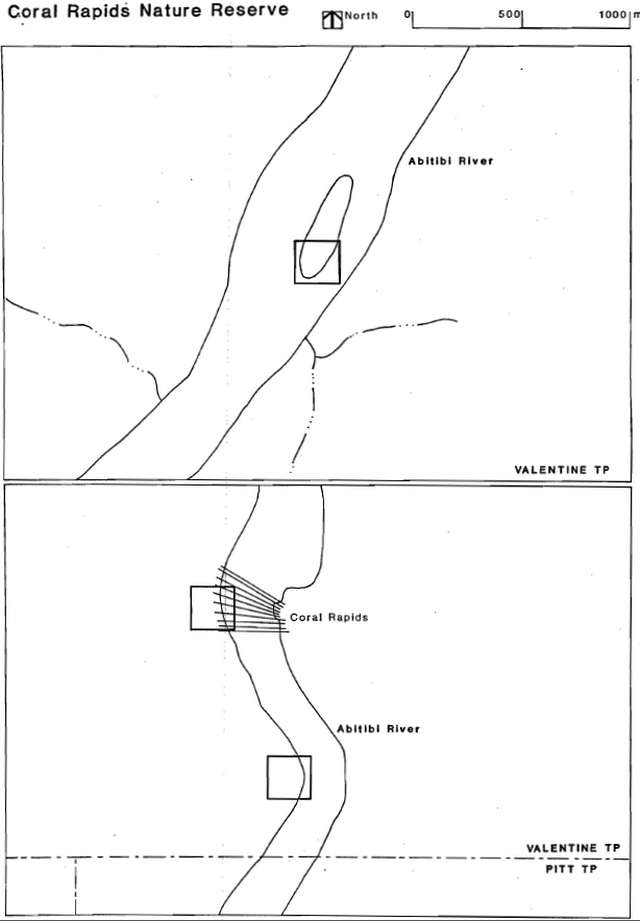
Name: Coral Rapids ( formerly Valentine Township’s 1,2 & 3)
Proposed class: Nature Reserve
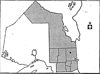
M.N.R. district: Cochrane
M.N.R. region: Northern
Area (ha): 4 ha x 3 + 12 ha
Regional setting map
Earth science target
| Geological theme | Feature |
|---|---|
| Paleozoic - Middle Devonian | Lower Shale Member - Williams Island Formation |
| Paleozoic - Middle Devonian | Kwataboahegan Formation |
| Paleozoic - Lower Devonian | Stooping River Formation |
Cultural resource target
theme segment: N/A
Inventories
| Level/type | earth science | life science | cultural | recreational |
|---|---|---|---|---|
| Reconnaissance completed | yes | no | no | no |
| Detailed completed | yes | no | no | no |
| Required | no | no | no | no |
Potential resource use conflict
O.H.E.P.C. Flooding Reserve
Material appended
D.L.U.G. extract: checked
Management statements
The Ontario Provincial Parks Planning Management Policies describes scientific research policy in nature reserves as follows: (NR-IV-1u).
Scientific research by qualified individuals, contributes to knowledge of natural history environmental management will be encouraged in Nature Reserves.
All research programmes will require the approval of the ministry of Natural Resources and must also meet all requirements under applicable provincial and federal legislation. The ministry may approve the removal of - geological samples - by qualified researchers - Approved research activities and facilities Hill be compatible with protection values - in individual Reserves, and will be subject to development and management policies for Nature Reserves unless special permission is given. Sites altered by research activities will be rehabilitated as closely to their previous condition as possible.
- issues: There are no relevant management issues for this park.
- resource management guidelines
Analysis: The nature reserve status of the park protects it from any form of degrading land use/activity including exploration/mining such as open pit mining.
Guidelines: Geological research may be authorized by the district manager provided that such activity enhances knowledge/understanding of the geological features, and that the results of such work are made available to M.N.R.
Mineral exploration/extraction will not be permitted.
Recommendation: That the guidelines be implemented with the approval of the plan.
Analysis: The park falls within traplines CC-181 and 189.
Guidelines: As hunting and trapping pose no threat to site values, these activities will be permitted.
Recommendation: That the guidelines be implemented with the approval of the plan and following appropriate changes to regulations under The Game and Fish Act.
Analysis: The park contains no known significant vegetation sites.
Guidelines: Silviculture which enhances the park’s geological features will be permitted.
Recommendation: That the guidelines be implemented with the approval of the plan.
Analysis: There is no leased or private land within the park. However, Ontario Hydro has flooding rights on this section of the Abitibi River.
Guidelines: No disposition of land will be permitted.
Recommendation: This guideline is already in effect.
- mineral resources management
- wildlife management
- vegetation management
- land management
- client services management guidelines
Basic information about Coral Rapids will be produced for geologists and students. Specifically, a small leaflet providing information about access, the park’s significance, references, and so forth, using photos, access and geological maps, and text should be adequate.
Prospective visitors should be warned of the resource’s vulnerability to damage from collectors; for example, in any publication which is produced for the park.
- Information:
- Education:
- at present, the site is undeveloped and access is restricted to the use of watercraft. This situation facilitates protection of the site from human impact, and will be maintained.
- research
Appendix 1: Natural resources background information
Frey (1980), describes the, bedrock geology of the Coral Rapids earth science Nature Reserve as follows.
The sites contain:
- the thickest exposed section of the Lower Shale Member of the Williams Island Formation (Paloezoic, Middle Devonian). Drillcore records describes sections up to 4o.9 m thick elsewhere in the Moose River Basin. The candidate site contains a mass of blue-grey, fossiliferous (macro- & micro-) clay shale slumped onto underlying limestone breccia of the Murray Island Formation (0.3 m thick) that overlies 10.5 m of the Moose River Formation limestone and dolomite. The Williams Island Formation presumably fills sinkholes in the underlying formations.
- [a] stratigraphic type section of the Kwataboahegan Formation (Paleozoic, Middle Devonian). This section is the standard reference to the lower part of the Kwataboahegan Formation and its contact relationship with the underlying Stooping River Formation. The Kwataboahegan Formation here consists of four bedding units of medium to coarse grained to finely granular, bituminous, and fossiliferous limestone totalling 10.1 m stratigraphic thickness. 1.3 m of Stooping River Formation limestone disconformably underlie the Kwataboahegan Formation at the base of the exposed section.
- a complete stratigraphic type section of the Stooping River Formation (Paleozoic, Lower Devonian), also its thickest (13.8 m) surficial exposure in the Moose River Basin. It is a valuable supplement to thinner sections in the designated type area in the Albany River delta. Contact relationships with the underlying Sextant Formation and the overlying Kwataboahegan Formation also are well exposed. The Stooping River Formation consists of eight bedding units of sandy to argillaceous (slaty), brown, and sparsely fossiliferous limestone.
Frey (1980) appraises the park’s earth science features as being of national significance (the Kwataboahegan Formation) and provincial significance (the Williams Island and Stooping River formations) according to the above-mentioned rationale.
Appendix #2 - District land use guidelines
17 a-h Earth science nature reserve features
a. Area Description
Earth science nature reserves are relatively small, significant or representative areas that are identified to achieve part of the Ministry’s protection heritage appreciation objectives. Across the Cochrane District, eight such sites have been identified outside of provincial parks and park candidates. These areas are:
| Site | Township | Area (ha.) | Significance |
|---|---|---|---|
| a | Hobson | 4.0 | Provincial |
| b | Hobson | 0.7 | Provincial |
| c | Valentine | 1.5 | Provincial |
| d | Valentine | 2.44 | National |
| e | Valentine | 2.44 | Provincial |
| f | Pitt | 2.44 | Provincial |
| g | Beniah | 1.22 | National |
| h | Wilkie | 1.22 | National |
These various geological features cover an area of 15.96 hectares in total. Six of these areas have reserved flooding rights that are held by Ontario Hydro.
Three of these sites are national recognized standard reference sections for various earth science formations. The other five are provincially recognized.
b. Land Use Intent
These areas are being recommended for park status.
Due to the size of the areas, and given the variety of uses that are ongoing within them, it is further recommended that most of the ongoing activities within the areas be permitted to continue. The exception to this would be commercial logging which is not recommended as a continuing use. An outline of those ongoing activities which are recommended for continuation is given in the Land Use Activity section, however it must be realized that in some instances further refinement may be required.
c. Land Use Activity for Area No. 17a-h
Earth Science Nature Reserve Features
| Activity | Acceptable Yes/No | Recommended Guidelines |
|---|---|---|
| Aggregate Extraction | No | |
| Agriculture | No | |
| Bait Fishing | No | Not applicable |
| Commercial Fishing | No | |
| Cottaging | No | |
| Crown Land Recreation | No | Not applicable |
| Forestry | No | |
| Hunting | Yes | It is recommended that hunting be permitted to continue. |
| Mining | No | |
| Provincial Parks | Yes | Recommended for park status. |
| Roads | No | |
| Rural Residential | No | |
| Sport Fishing | Yes | It is recommended that sport fishing be permitted to continue. |
| Tourism | No | No commercial facilities will be allowed. |
| Trapping | Yes | It is recommended that existing trapping activity be permitted to continue. |
| Wildlife Viewing | Yes | |
| Wild Rice Harvesting | No | |
| Urban Development | No | |
| Other | Yes | The Ministry will continue to work closely with Ontario Hydro concerning the planning and design of any future hydraulic proposals in the area. |
References
Frey, E. Candidate Earth Science Nature Reserves
, Northern Region (unpublished), 1980..
Ontario Ministry of Natural Resources. Cochrane District Land Use Guidelines, Background Information, 1981.
Ontario Ministry of Natural Resources. Cochrane District Land Use Guidelines, Proposed Policy and Planning Options, 1983.
Ontario Ministry of Natural Resources, Ontario Provincial Parks Planning and Management Policies, 1978.
Ontario Ministry of Natural Resources, Report of the Task Force on Parks System Planning, Volume 1, 1981.
Sanford, B.V. and A.W. Norris. Devonian Stratigraphy of the Hudson Platform, Parts I & II, Geological Survey of Canada, Memoir 379, 1975.
Interim management statement district approval form
I have read this Interim Management Statement and weighed its recommendations with respect to my area of assigned responsibility. I have made my views known and have participated in the District decision regarding the interim policies that it contains.
Signed by the following:
- Parks/Engineering Supervisor
- Fish & Wildlife/Lands Supervisor
- Rorest Management Supervisor
- Regional Planner