Elk tag quotas
Find information on elk harvest areas, hunt codes and annual resident elk tag quotas.
Overview
Elk tags are valid for areas smaller than a wildlife management unit (WMU), referred to as harvest areas. Use the map and descriptions to find your harvest area.
For a chance to hunt elk, you must apply to the elk draw for a tag and pay the draw application fee. Applicants cannot select a bull or cow tag type; these will be randomly assigned. Learn how to apply to hunt big game.
Note: Hunters who are successful in the elk draw and are issued an elk tag are not eligible to receive another elk tag in their name for 5 years, but may continue to be listed as a member of a group and party hunt for elk during this time.
Elk harvest areas
For elk harvest management, each tag is valid in a specific harvest area within a WMU.
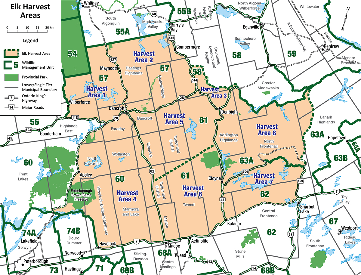
Harvest area 1: The part of WMU 57 west of a line formed by highway 62 south of Maynooth and highway 127 north of Maynooth.
Harvest area 2: The part of WMU 57 east of a line formed by highway 62 south of Maynooth and highway 127 north of Maynooth.
Harvest area 3: The part of WMU 58 south and west of the Madawaska River.
Harvest area 4: The part of WMU 60 east of highway 28.
Harvest area 5: The part of WMU 61 north of the northern edge of the Hydro One transmission line running through Tudor, Grimsthorpe and Effingham Townships.
Harvest area 6: The part of WMU 61 south of the northern edge of the Hydro One transmission line running through Tudor, Grimsthorpe and Effingham Townships.
Harvest area 7: The part of WMU 62 north of highway 7.
Harvest area 8: The part of WMU 63A west of the former K&P Railway line.
2025 hunt codes and resident elk tag quotas
| Elk harvest area | Hunt code | Bull tag quota | Cow tag quota |
|---|---|---|---|
| 1 | 100 | 0 | 0 |
| 2 | 101 | 2 | 2 |
| 3 | 110 | 0 | 0 |
| 4 | 120 | 0 | 0 |
| 5 | 130 | 2 | 2 |
| 6 | 131 | 2 | 2 |
| 7 | 140 | 0 | 0 |
| 8 | 150 | 0 | 0 |