Pantagruel Creek Provincial Park Management Statement
This document provides policy direction for the protection, development and management of Pantagruel Creek Provincial Park and its resources.
August, 1986
Regional Director’s approval statement
This revised Interim Management Statement will provide interim direction for the management of the above Provincial Nature Reserve until a comprehensive Park Management Plan is prepared.
This statement will provide the basis for the subsequent preparation of the Park Management Plan.
I am pleased to approve this Interim Management Statement
M. S. Millar
A/Regional Director
North Central Region
Revised March 1991
Background information
- Date: 27.05.89
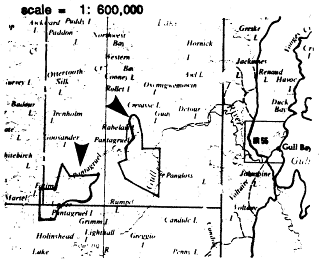
- Name: Pantagruel Creek
- Class: Nature Reserve
- M.N.R. district: Nipigon
- M.N.R. region: North Central
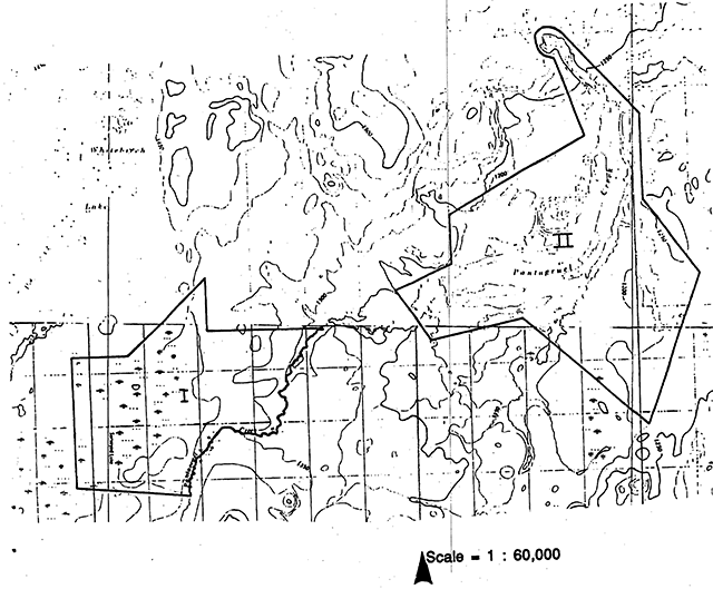
- Total area (ha): 2,685
- Land:
- Water:
- Site region: 3W
- Site district: 3
- Date in regulation: May 27, 1989
Targets
Life science representation
- Site type/landscape unit
- Undocumented
- Species/communities
- [no information]
Earth science representation
- Geological theme
- Timiskaming Interstadial
- Feature
- Kalashk Spillway representation: first post-glacial connecting of glacial Agassiz anctearly Lake Superior stages.
Cultural resource representation
- Theme
- Unknown
- Theme segment
- [no information]
Recreation opportunities
- Day use: N/A
- Car camping: N/A
- Wilderness/back country: N/A
Inventories
| level/type | reconnaissance/completion date | detailed completion date | required? |
|---|---|---|---|
| earth science | checksheet | detailed inventory | |
| life science | brief survey | ||
| cultural | brief survey | ||
| recreational | |||
| other |
Pantagruel Creek Provincial Nature Reserve interim management statement
I Land tenure
All land within the Nature Reserve is Crown Land.
The land surrounding the Nature Reserve is within the Spruce River Forest Management Agreement Area. The area of the Nature Reserve is excluded from this agreement.
II Land acquisition/disposition
The boundary for the candidate park was developed in consideration of the natural features to be protected, the natural features to be protected, and subsequent to negotiations held with the F.M.A. agreement holder, Inc. The area regulated under the Provincial Parks Act consists of two parts with an intervening area of Crown Land where timber management activity may occur.
III Existing/proposed development
There is no development in the Park area to date and none is planned in the near future.
IV Recreational activities
N/A
V Commercial activities
Trapping occurs within the area under the authority of the Gull Bay Band trapline licence. The entire candidate area is contained with the boundary of NG-24 which supports many of the 21 trappers from Gull Bay. No trapline cabins exist in the area.
Guideline
As per N.D.L.U.G., trapping activities carried out by Status Indian People will be allowed to continue in their treaty area but construction of trapline cabins will not be permitted.
Mineral potential in the area is low and the area has been withdrawn from staking under the Mining Act.
VI Native interests
The Park lies within the area covered by the Robinson-Superior Treaty of 1850. Status Indians of the Gull Bay Band from the nearby Gull Bay Reserve 55 are adherent to this treaty.
Guideline
Status Indians will be allowed to continue their traditional activities.
The Park is also within or immediately adjacent to the area identified in the Anishanabek land claim. It is not known what effect, if any, this land claim would have on the Park.
VII Natural resources
This candidate is an excellent example of the Kaiashk Spillway which is the first post-glacial connecting route of the glacial Lake Agassiz and early Lake Superior stages.
Guideline
The area is essentially inaccessible to anything but helicopters at present. To preserve the integrity of the site, only those uses identified in the land use activity table are permitted.
The current Timber Management Plan for the Spruce River Forest contains a prescription for timber operations proposed for areas adjacent to the Nature Reserve. The integrity of the landforms associated with these areas will be protected by designating the time of year harvesting may occur, by restricting the removal of aggregate, controlling the location, constructions and exctent of roads, and the type of harvesting machinery to be used and the regeneration techniques applied.
Normal forest fire suppression will take place within the Nature Reserve area, except that, the use of heavy for bulldozing fire breaks or other forms of ground disturbance should not occur.
Until appropriate measures are identified in a Management Plan, insects and diseases will be controlled as is deemed necessary.
More information is required to better understand the Park resource representation, features and landscapes.
Guideline
Brief life science and cultural resources surveys and a detailed earth science inventory will be conducted as an integral part of the preparation of the Management Plan.
Insects and diseases will be controlled as is deemed necessary.
The approach and format for the inventory and survey work will be consistent with guidelines prepared by the Parks and Recreational Areas Branch and the Ministry of Culture and Communications.
VII Cultural resources
N/A
IX Client services
N/A
X Research/inventories
Research proposals which support earth and life science inventory work will be encouraged. Specifically, research of the surficial geology, glaciation history, and ecological associations would be beneficial.
Guideline
Research proposals must be approved and conducted in accordance with the Parks and Recreational Areas Branch policy concerning research.
References/sources
O.M.N.R./Abitibi-Prince Inc. 1981. Spruce River Forest -Forest Management Agreement #500700.
O.M.N.R. 1981. Backgrounder Land Use Guidelines.
O.M.N.R. 1983. Nipigon District Land Use Guidelines.
Kor, P. 1980. Earth Science Inventory Checksheet.
Nipigon District Staff. Impact Assessment Sheet.
Elson, J. A. 1967. Geology of Glacial Lake Agassiz. In Life, Land, and Water: Mayor-Oakes, W.J. (Ed.). University of Manitoba Press. 87-96 p.
Saarnisto, M. 1974. The Deglaciation History of the Lake Superior Region and its Climactic Implications. Quat. Res., V. 4. 316-330 p.
Sage, R. P., F. W. Breaks, S. M. Stott, G. M. McWilliams and D. Robertson. 1974. Operations Ignace-Armstrong. Obonga Lake - Lake des Iles Sheet, District of Thunder Bay, Ontario, Div. Mines. Geol. Ser., Prelim. Map p. 963. Scale 1 in = 2mi.
Teller, J. T. and L. H. Thorleifson. 1983. The Lake Agassiz Lake Superior Connection. 10.: Glacial Agassiz. J. T. Teller and L. Clayton (Editors). Geol. Assoc. Can., Special Paper 26, 261-290 p.
Thurston, P. C. and others. 1963. Obonga-Leigh Lakes Area. Goosender Lake Sheet. District of Thunder Bay. Ontario Dept. Mines. Prelim. Geol. Map No. P460. Scale 1 in = ¼ mi.
Zoltai, S. C. 1965 Glacial features of the Quetico-Nipigon Area, Ontario. Can. Jour. Earth Sci, V.2. 247-269 p.
Zoltai, S. C. 1967. Eastern Outlets of Lakei Agassiz. In life, Land and Water: W. J. Mayor-Oakes (Ed.). University of Manitoba Press. 107-120 p.
Appendix I: Land use activity for Pantagruel Creek
| Activity | Acceptable Yes |
Acceptable No |
Recommended Guidelines |
|---|---|---|---|
| Aggregate extraction | X | ||
| Agriculture | X | ||
| Bait fishing | X | ||
| Commercial fishing | X | ||
| Cottaging | X | ||
| Crown land recreation | Not applicable to Parks. | ||
| Forestry | X | ||
| Hunting | X | ||
| Mining | X | ||
| Provincial parks | X | ||
| Roads | X | ||
| Rural residential | X | ||
| Sport fishing | X | ||
| Tourism | X | ||
| Trapping | X | It is recommended that existing trapping activity be permitted to continued for Status Indians enjoying treaty rights. | |
| Wildlife viewing | X | ||
| Wildrice harvesting | X | ||
| Urban development | X |
Source: Nipigon District Land Use Guidelines