Prime agricultural areas
Learn about the provincial land use policy requirements for planning authorities to identify, designate and protect prime agricultural areas.
Overview
The Provincial Planning Statement (PPS), 2024 and the Greenbelt Plan, 2017 require prime agricultural areas, including specialty crop areas, to be designated and protected in municipal official plans based on provincial guidance or informed by mapping obtained from the Ministry of Agriculture, Food and Agribusiness (OMAFA).
The designation of prime agricultural areas is required to be maintained over time. It is important to consult with the province on the need for updates prior to a municipality undertaking an official plan review.
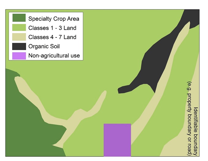
Prime agricultural areas
Prime agricultural land is mainly concentrated south of the Canadian Shield where high capability soils predominate. Northern Ontario also has some large areas of prime agricultural land and lower classed land with a local concentration of agriculture that may be considered prime agricultural areas.
Prime agricultural areas represent large, generally contiguous blocks of land that enable current and future opportunities for agriculture. They are characterized by the presence of:
- prime agricultural land, defined as specialty crop areas and/or areas with Canada Land Inventory (CLI) classes 1–3 lands
- other areas associated with prime agricultural land including CLI classes 4–7 lands and additional areas with a local concentration of farms with characteristics of ongoing agriculture
- agricultural areas with organic soil (not part of the CLI classification system)
Prime agricultural areas are working landscapes where normal farm practices are promoted and protected. Small pockets of existing non‑agricultural uses may be found within these landscapes, but they do not change the fundamentally agricultural character of the area.
Normal farm practices may involve activities that may not be compatible with sensitive non‑agricultural uses because they generate:
- noise
- dust
- vibration
- smoke
- flies
- light
- odour
Conflict between agricultural and non‑agricultural uses can impair farm operations, making large, continuous areas for agriculture essential to reduce disruption and support efficient farming.
Farm operators often need to move large, slow‑moving equipment on roads to plant, harvest, and transport crops, which can become more difficult and unsafe when fields are fragmented, or nearby land uses are incompatible. Some parts of the agri‑food supply chain also depend on a critical mass of primary agriculture nearby to remain viable. For these reasons, provincial policy protects prime agricultural areas from non‑agricultural uses and supports reserving large, continuous areas for agriculture.
Mapping and designating prime agricultural areas
Why prime agricultural areas must be designated
Designating prime agricultural areas helps to ensure these non-renewable resources are protected and considered when land use decisions are made. Maintaining large, continuous areas also supports normal farm practices and helps reduce potential land use conflicts over time.
Policy direction and municipal role
The PPS 2024 and provincial plans (such as the Greenbelt Plan) require prime agricultural areas to be protected and designated for long term use for agriculture.
Municipalities designate prime agricultural areas in their official plans, supported by the mapping and delineation of these areas as part of establishing and maintaining the agricultural land base. Considering the size and continuity of these areas supports efficient farm operations and helps avoid land use compatibility challenges.
Mapping within the Greenbelt Plan area
Within the Greenbelt Plan area, prime agricultural areas have been mapped by OMAFA through the Provincial Agricultural Land Base Map (2018), available on the Agricultural System Portal. Planning authorities must use this mapping to implement the provincially identified agricultural system and agricultural land base mapping through their official plans, consistent with applicable plans and implementation procedures.
Approaches outside the Greenbelt Plan area
Outside of the Greenbelt Plan area, where mapping or technical analysis is required to support the identification and designation of prime agricultural areas in official plans, OMAFA recommends that municipalities use the Land Evaluation and Area Review (LEAR) methodology, informed by the PPS 2024 and provincial guidance and mapping, where available. The Agricultural Land Evaluation System (ALES) is an alternative methodology that may be used instead of a LEAR, to support the designation of prime agricultural areas.
When studies may or may not be needed
In municipalities where lands outside settlement areas meet the definition of a prime agricultural area, a study may not be required to support designation in an official plan. In areas with more diverse soils or land use patterns, municipalities typically begin the designation process by undertaking a study to identify candidate prime agricultural areas.
Typical inputs to LEAR or ALES studies
Studies to support the identification of candidate prime agricultural areas, such as LEAR or ALES, typically analyze factors such as:
- CLI soil capability
- lot sizes to assess fragmentation
- existing agricultural and non‑agricultural land uses
From study to designation
Once candidate areas are refined and final prime agricultural areas are identified, designation typically occurs through an official plan amendment process with public notification and input, often as part of a municipal comprehensive review or official plan review, as applicable.
Municipal approaches to designation
Common approaches across Ontario
Most municipalities with concentrations of prime agricultural land designate prime agricultural areas in their official plans and must ensure that the full meaning of “prime agricultural areas,” is reflected in those designations.
Regional variations in designation approaches
In Southwestern Ontario, many municipalities designate all land outside settlement areas as prime agricultural area, reflecting the widespread quality of agricultural soils and the prevalence of farming in the area.
In other parts of the province, municipal official plans commonly include both “prime agricultural area” and “rural lands” designations, indicating that lands outside settlement areas may contain a broader mix of prime agricultural land and lower‑capability land.
Variations across planning tiers and contexts
In some cases, prime agricultural areas are designated and mapped in lower‑tier (town, city, township) official plans but are not yet reflected in upper‑tier (county, region, district) official plans.
Some municipalities, primarily in Northern Ontario, do not have an approved official plan or only have a draft official plan. In these cases, consultation with the municipality and OMAFA is recommended to confirm how prime agricultural areas are to be recognized.
Early consultation with OMAFA
Municipalities are encouraged to consult with OMAFA early, prior to commencing a study and during official plan reviews, to discuss whether new or updated agricultural land base mapping may be warranted. OMAFA can provide data, technical support and guidance on the appropriate application of LEAR and ALES.
When studies may or may not be needed
In municipalities where lands outside settlement areas clearly meet the definition of a prime agricultural area, a formal LEAR or ALES study may not be required to support mapping in an official plan. However, where land use patterns have changed, new information is available or official plans are being updated, municipalities may consider undertaking or updating LEAR or ALES studies to ensure prime agricultural area mapping remains current, defensible and consistent across jurisdictions.
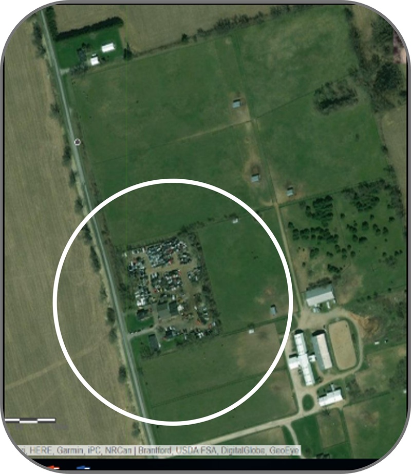
Non-agricultural uses in prime agricultural areas
Prime agricultural areas may include small pockets of non‑agricultural uses within the working agricultural landscape, such as:
- golf courses
- cemeteries
- commercial and residential lots
These uses may have been approved before current policies were in place and, if permitted by an approved official plan and zoning by‑law, may continue as site‑specific exceptions limited to the type and scale already approved.
Being located within a prime agricultural area means that prime agricultural area policies continue to apply to sites with existing non‑agricultural uses. Normal farm practices must be promoted and protected, and severances may only be permitted under specific circumstances.
Proposals for new or expanding non‑residential, non‑agricultural uses must meet Minimum Distance Separation (MDS I) requirements, demonstrate need and evaluate alternative locations to avoid prime agricultural areas or, where avoidance is not possible, lower‑priority agricultural lands.
Impacts must be mitigated to the extent feasible, recognizing that the long‑term use of land in prime agricultural areas is intended for agriculture. OMAFA’s Publication 851: Guidelines on Permitted Uses in Ontario's Prime Agricultural Areas provide additional direction to support implementation of provincial policy and identify permitted uses and diversification opportunities.
If new non‑agricultural uses are approved within prime agricultural areas (excluding settlement area expansions), the lands remain designated as prime agricultural area. Where an approved non‑agricultural use ceases, any future land use planning applications must be consistent with prime agricultural area policies.
The following supporting prime agricultural area identification tools and data sources may be used alongside ALES or LEAR to inform analysis and mapping:
- Use of soil and CLI information for agricultural land use planning in Ontario – Identifies agricultural soil capability to support assessment of agricultural potential.
- Agricultural Information Atlas (AgMaps) – A geographic information system (GIS) tool that allows users to view and overlay agricultural datasets to support mapping work.
- Agricultural system Portal – Provides information and spatial data related to Ontario’s agricultural system for land use planning.
- Ontario Soils GeoHub – Provides access to authoritative provincial geospatial datasets used in land use planning.
Municipalities are encouraged to consult with the Ministry of Municipal Affairs and Housing (MMAH) and OMAFA at the time of an official plan review to confirm whether updates to mapping are required.