Wagong Lake Forest Conservation Reserve Management Statement
This document provides policy direction for the protection, development and management of the Wagong Lake Forest Conservation Reserve and its resources.
Statement of Conservation Interest (C243)
Ministry of Natural Resources
Sault Ste. Marie District
Northshore Area
February, 2005
Ce document est seulement disponible en anglais.
Approval statement
I am pleased to approve this Statement of Conservation Interest (SCI) for Wagong Lake Forest Conservation Reserve (C243).
Wagong Lake Forest Conservation Reserve was affected by one of the largest forest fires in the province’s history, and was designated to protect a naturally regenerated forest interspersed with old-growth communities. Black spruce, jack pine, trembling aspen and white birch communities dominate this site, and are found on alternating lowland and upland hills of glacial outwash. Nearly 25 percent of this 2,381 hectare site is marine-based. Lakes within this site are designated for remote tourism, and most serve as important fisheries for lake trout, whitefish and northern pike. Wetlands within the conservation reserve are a dominant feature providing habitat for moose. This conservation reserve was regulated on April 6, 2001, and is situated approximately 75 kilometres north of the City of Elliot Lake in Gisborn, Lawlor, Laughren and Gilbertson townships.
Direction for establishing, planning and managing conservation reserves is defined under the Public Lands Act, the Ontario’s Living Legacy Land Use Strategy, and other applicable policies. The specific direction for managing this conservation reserve is in the form of a basic SCI, which defines the area to which the plan applies, provides the purpose for which the conservation reserve has been proposed, and outlines the Ministry of Natural Resources' management intent for the protected area. This SCI has been created with input from program specialists within Sault Ste. Marie District. It will provide both the foundation for continued monitoring of activities and guidance for managing the conservation reserve. More detailed direction at this time is not anticipated. However, should significant facility development be considered or complex issues arise requiring additional studies, more detailed management direction in the form of special protection measures or a detailed Resource Management Plan will be prepared with full public consultation.
Public and Aboriginal comments were solicited prior to the regulation of this conservation reserve. An additional 15-day review period took place in December, 2004 that provided stakeholders with an opportunity to comment on the draft SCI. Some Aboriginal communities chose not to participate in either of these comment periods. Comments from the review period have been considered in the finalization of this document.
The management guidelines outlined in this SCI will be implemented by the Northshore Area Supervisor, and will be reviewed every five years and amended as required by the District Planner, Sault Ste. Marie District, Ministry of Natural Resources.
Written by:
Jennifer Cywink
Protected Areas Planning Intern
Date: February 22, 2005
Submitted by:
Erin Nixon
District Planner
Date: February 23, 2005
Recommended for approval by:
Dick Hagman
Northshore Area Supervisor
Date: March 2, 2005
Recommended for approval by:
Trevor Woods
District Manager
Sault Ste. Marie
Date: March 21, 2005
Approved by:
Rob Galloway
Regional Director
Northeast Region
Date: April 05, 2005
1.0 Introduction
The following document is a Statement of Conservation Interest (SCI) for Wagong Lake Forest Conservation Reserve (C243). The purpose of this SCI is to identify and describe the natural, recreational, and cultural values of Wagong Lake Forest Conservation Reserve and to outline the Ministry of Natural Resources' management intent for this area. Sections 1 through 3 of this document highlight the provincial context in which it was produced, state its goal and objectives, and summarize the planning process for conservation reserves. Sections 4 through 7 are specific to Wagong Lake Forest Conservation Reserve and provide background information and management direction for the site. Section 8 outlines the requirements for continued implementation and review of this document.
Management direction specified in this SCI will serve to protect the conservation reserve for the benefit of all Ontario residents. This direction will comply with the land use intent stated in the Ontario’s Living Legacy Land Use Strategy (LUS) (OMNR 1999) and associated policy clarification statements. Additionally, this conservation reserve will be managed under the Public Lands Act (OMNR 1997a), and will comply with all legal requirements as specified under the Environmental Assessment Act (R.S.O. 1990, Chapter E.18).
1.1 Provincial context
Ontario’s network of natural heritage areas has been established to protect and conserve areas representative of the diversity of the natural regions of the province, including the species, habitats, features, and ecological systems which comprise that natural diversity. Protected natural heritage areas are a key component in the sustainable management of natural resources. They ensure that representative sites within the larger managed landscape are retained in as natural a state as possible.
On July 16, 1999, the Ontario’s Living Legacy Land Use Strategy was released to guide the planning and management of much of Ontario’s Crown lands. Extensive consultation was conducted during the development of the LUS. The objectives of the LUS are to complete Ontario’s system of parks and protected areas; recognize the land use needs of the resource-based tourism industry; provide forestry, mining and other resource industries with greater certainty around land and resource use; and enhance hunting, angling and other Crown land recreational opportunities (OMNR 1999).
The LUS (OMNR 1999) contributes to Ontario’s system of protected natural heritage areas by designating 378 new areas to be protected. These areas are considered to be significant and require protection from incompatible activities in order for their values to endure over time. Wagong Lake Forest Conservation Reserve is now part of Ontario’s system of protected areas. Impacted by one of the largest forest fires in Ontario’s history, this conservation reserve provides an excellent representation of a naturally regenerated forest, in a remote and virtually undeveloped environment. It protects sand and gravel hills on alternating upland and lowland formations dominated by forest communities of jack pine (Pinus banksiana), black spruce (Picea mariana), trembling aspen (Populus tremuloides) and white birch (Betula papyrifera), including some old-growth stands (Burkhardt et al. 2004). Meadow marshes, shore fens, conifer swamps, treed bogs and semi-treed bogs are dominant features of the site which provide important habitat for moose (Alces alces). Lakes, rivers and creeks contribute to the headwaters for the Mississagi River system and provide important coldwater ecosystems for lake trout (Salvelinus namaycush), whitefish (Coregonus clupeaformis) and northern pike (Esox lucius). Additionally, several lakes within the site have been designated as tourism lakes (OMNR 1983).
The Ministry of Natural Resources has established conservation reserves as a tool to protect natural heritage areas on public lands, while permitting most traditional public land uses to continue. These uses include recreational activities, such as hunting and fishing, and the traditional activities of Aboriginal communities, as defined under applicable Aboriginal treaties.
Lands designated as conservation reserves in the LUS (OMNR 1999) are removed from the Sustainable Forest License area, and mining and surface rights are withdrawn from staking under the Mining Act (RSO 1990 Chapter M.14).
The LUS (OMNR 1999) and subsequent policy clarification statements (OMNR 2000) outline the general land use policy and management direction for new conservation reserves. Each new conservation reserve will have a planning document, either a SCI or, in more complex situations, a Resource Management Plan that details site-specific management direction.
2.0 Goal and objectives of the SCI
2.1 Goal
The goal of this SCI is to provide the framework and direction to guide management decisions affecting Wagong Lake Forest Conservation Reserve.
2.2 Objectives
The following objectives are identified as the means to achieve the above stated goal:
- To describe the site’s current state of the resource in terms of its values and existing uses and activities
- To outline the Ministry of Natural Resources' management intent for the protected area
- To determine the land use compatibility of current land uses, and to develop specific guidelines and prescriptions to manage these uses
- To create public awareness of the values within this conservation reserve by providing information on the resources it contains and protects, and to support responsible stewardship through partnerships with local stakeholders
- To identify research, client services, and/or marketing strategies that may contribute to sound long-term management of the conservation reserve
- To identify the monitoring and/or research necessary to maintain the integrity of protected values
- To provide direction for the evaluation of proposed new uses or economic ventures through the application of the Test of Compatibility (see Appendix C) and applicable Environmental Assessment Act This test will evaluate the impact of suggested use(s), either positive or negative, on the protected values of the conservation reserve
3.0 Management planning
3.1 Planning for a Conservation Reserve
The planning process for a conservation reserve consists of regulating the site and preparing a site specific management plan. Consultation with the public, special interest groups, Aboriginal communities and industry occur during site identification, boundary finalization, and management planning; however it is noted that some Aboriginal communities do not wish to participate in these consultation efforts. Regulation of a conservation reserve involves preparing a legal description of site boundaries, removing the site from the Sustainable Forest License area, and withdrawing the site from staking under the Mining Act (RSO 1990 Chapter M.14). Once a conservation reserve is regulated, the level of management planning required to fulfill the protection targets is determined, and either a basic or enhanced SCI or a Resource Management Plan is prepared.
A basic SCI is prepared when there is no deviation from the land use direction provided in the LUS (OMNR 1999) and there are minor issues that require resolution. An enhanced SCI is an intermediary document which is used when a site requires more detailed management direction than would be provided by a basic SCI, but does not have issues significant enough to warrant the preparation of a Resource Management Plan (RMP). A RMP is prepared in situations where one or more complex issues have to be addressed, or where there is widespread public interest in a site. Whichever the determination, the plan must be completed within three years of the conservation reserve’s regulation date. The guidelines for the preparation of these documents are provided in Procedural Guidelines A - Resource Management Planning (Conservation Reserves Procedure PL3.03.05, Public Lands Act, OMNR 1997a) and the Northeastern Region Guidelines on the Planning Process for Conservation Reserves: Statement of Conservation Interest and Resource Management Plan (Thompson 2001).
A SCI is essentially a management plan which receives its direction from the LUS (OMNR 1999). The purpose of a SCI is to identify the state of the resource in terms of the site’s values and its current land use activities, and to outline the Ministry of Natural Resources' management intent for the conservation reserve. Basic SCIs typically have a 15-day public consultation period, whereas enhanced SCIs and RMPs have a longer consultation period. Upon completion of this public review, the SCI, or RMP, is revised as necessary and approved by the appropriate Regional Director.
Existing permitted uses within conservation reserves may continue, unless they are shown to have a significant negative impact on the values protected by the site. A review/evaluation mechanism is in place to address proposed new permitted uses or land use proposals. The Test of Compatibility (see Appendix C) as outlined in the Public Lands Act Policy PL 3.03.05 (OMNR 1997a), and/or other standard Ministry of Natural Resources' environmental screening processes, are used to screen future proposals. Where cultural resources may be impacted, proposals may be screened through Conserving a Future for our Past: Archaeology, Land Use Planning & Development in Ontario, Section 3 (Ministry of Culture 1998).
Public comment may be solicited during a review of any future land use proposals that require new decisions to be made. Appropriate Environmental Assessment Act (R.S.O. 1990, Chapter E.18) requirements and amendment processes will apply to any future proposal and/or any significant change in management direction being considered for a site.
3.2 Planning process for Wagong Lake Forest Conservation Reserve
Wagong Lake Forest Conservation Reserve was proposed as a conservation reserve in the LUS (OMNR 1999). Consultation has occurred with the public, Aboriginal communities, and industry, although, some Aboriginal communities did not wish to participate in the consultation efforts. The boundary of the site was regulated through an amendment to Ontario Regulation 805/94 of the Public Lands Act on April 6, 2001, by Ontario Regulation 86/01. A copy of the public consultation materials from the boundary regulation phase can be found in Appendix E.
To date, no significant issues related to land use in this conservation reserve have been identified. For this reason, it was determined that a basic SCI will adequately identify the site’s significant features and serve as the appropriate format for delivering the management guidelines. It should be noted that this document addresses only those issues or land use proposals currently known to the District Manager. The direction provided by this SCI, and future management decisions, will work to resolve any potential land use conflicts and to ensure that identified values continue to be adequately protected.
3.2.1 Planning area
The planning area for this SCI consists solely of the regulated boundary for Wagong Lake Forest Conservation Reserve. However, to fully protect values within the conservation reserve, the area beyond the regulated boundary may require additional consideration when larger land use planning initiatives pose potential negative impacts on the conservation reserve. The forest management planning process is an example of how adjacent land management may consider sensitive features within the conservation reserve boundary.
4.0 Background information
4.1 Location and site description
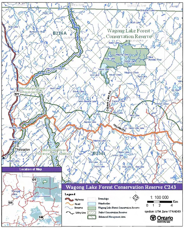
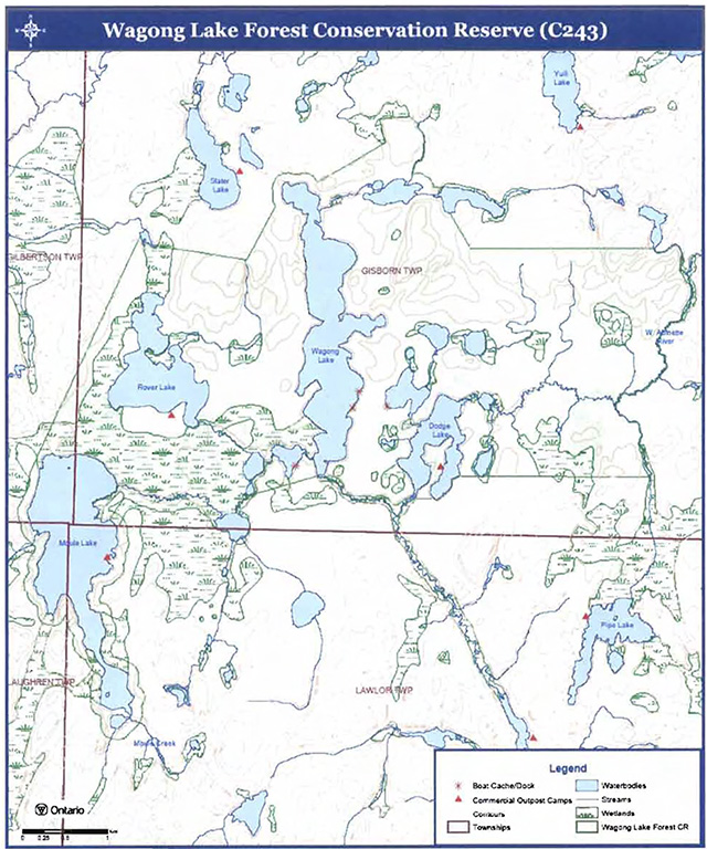
Wagong Lake Forest Conservation Reserve is located approximately 75 km north of the City of Elliot Lake in Gisborn Township, extending partially into Lawlor, Laughren and Gilbertson townships. This site was regulated on April 6, 2001, and is 2,381 ha in size (see Figure 2). Nearly 25 percent of the site is marine-based. It encompasses one designated lake trout Jake, which also informally supports remote tourism, and three additional lakes designated for remote tourism
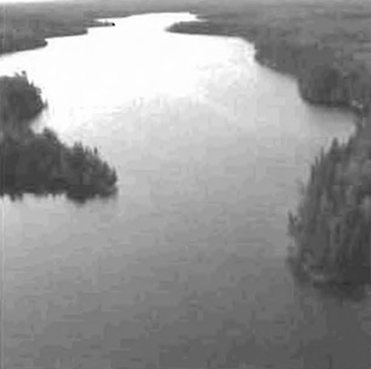
Figure 1: Wagong Lake (shown) the largest lake in the conservation reserve, is designated as a lake trout Jake (OMNR 1983).
(Photo by J. Young; September, 2003)
Whenever possible, recognizable natural and cultural features, such as creeks, shorelines or old roads, have been used to delineate conservation reserve boundaries to facilitate on-the-ground identification. The southwesterly portion of the site is defined by a 120-m buffer from the water’s edge of Moule Lake. The western, northern and southern boundaries of the site are defined by a series of vectors and buffer areas around small lakes. The centre-line of the West Abinette River forms the eastern boundary (see Appendix A, Map 1).
Figure 2: Site Location for Wagong Lake Forest Conservation Reserve (C243)
Enlarge figure 2: Site Location for Wagong Lake Forest Conservation Reserve (C243)
Wagong Lake Forest Conservation Reserve is located in the northern extent of the Northshore Forest. The Cypress Lake Road approaches the conservation reserve from the south, but is designated as a restricted access, non-public road. Highway 129 is approximately 15 km west of the site, and the Hinkler Road, a forest access road, is roughly 10 km to the south. Access to the conservation reserve is gained via small aircraft, by boat or hiking.
Table 1. Location and administrative details for Wagong Lake Forest Conservation Reserve.
| Name | Wagong Lake Forest Conservation Reserve (C243) |
|---|---|
| Site Region - Site district (Hills 1959) | 4E-3 |
| Eco Region - Eco district (Crlns and Uhlig 2000) | 4E-3 (Mississagi) |
| OMNR Administrative Region/District/Area | Northeast Region/Sault Ste. Marie District/ Northshore Area |
| UTM co-ordinates | Zone 17 NAD 83- 354520, 5225687 |
| Area | 2,381 ha |
| Nearest city/town | Approximately 75 km north of the City of Elliot Lake |
| Township(s) | Gisborn, Lawlor, Laughren, Gilbertson |
| OBM Numbers | 2017350052200 |
| Topographical map number/name | NTS 41 0 02- White Owl lake |
| Wildlife Management Unit | 38 |
| Forest Management Unit | Northshore Forest |
| Regulated | April 6 2001 |
| SCI completed | February, 2005 |
Wagong Lake Forest Conservation Reserve is located within Site District
The conservation reserve is situated within the transitional zone between the Boreal and Great Lakes-St. Lawrence forests. It contains typical Boreal Forest communities in the north, with some scattered Great Lakes-St. Lawrence species in the south. Balsam fir, black spruce, trembling aspen, and scattered white birch, dominate on-site forest communities. On rocky shores and ridges, white pine (Pinus strobus) and red pine (P. resinosa) is present, with jack pine and black spruce found on sand terraces along rivers and on poor, rocky soils. The diversity of Wagong Lake Forest Conservation Reserve is considered low; although a variety of wetlands, coldwater lakes and streams, and patches of old forest stands, throughout the site, increase the diversity (Burkhardt et al. 2004). Photos of the conservation reserve can be found in Appendix B.
4.2 History of the site
Wagong Lake Forest Conservation Reserve was subject to two extensive forest fires in the 1940s. One of the largest and most disastrous wildfires in Ontario, the "Mississagi '48" involved more than 345,000 ha and 27 townships, and burned for 3 months. In subsequent months, logging operations were undertaken In an attempt to salvage as much red and white pine timber as possible, in areas affected by these fires (OMNR 1996). The most northerly townships, including the area within this conservation reserve, were generally not harvested due to difficult accessibility. Areas of the site affected by fire have been unassisted in their rehabilitation, and essentially demonstrate an excellent representation of natural forest succession, post fire disturbance (Young 2004). Older stands of black spruce, trembling aspen, jack pine and red pine, unaffected by the fires, contribute to the conservation reserve’s unique values.
The logging industry has played a major role in the area further south of the conservation reserve for the past century. According to Ministry of Natural Resources' staff, logging immediately south of the conservation reserve only began in the 1980s (Campbell pers. comm.). Recent harvesting has occurred in the immediate vicinity of the conservation reserve, east of Moule Lake. Both the Hinkler and Cypress Lake roads have been utilized by logging companies since their construction in the 1970s.
Figure 3: Remote tourism outpost camp on Moule Lake.
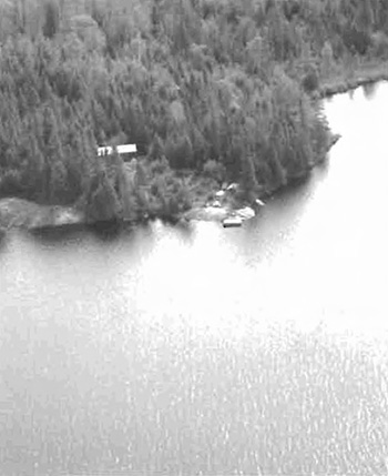
Moule, Rover and Dodge lakes, located within the site, have a rather detailed history of commercial outfitting and recreational remote tourism activities. In the early 1980s, a land use permit (LUP) was issued for the establishment of a commercial outpost camp along the eastern shore of Moule Lake, which provided big game hunting experiences and angling for northern pike (see figure 3). Similarly, the Rover Lake outpost camp was established in the late 1970s. Temporary tents were set up on the Rover Lake site until the present day building was constructed, around 1995. Today, both the Moule and Rover outfitting facilities belong to the same operator. The half hectare LUP at the north end of Dodge Lake was originally obtained around 1978. In 1986, an unauthorized cabin on Wagong Lake was relocated to this LUP site, which continues to be promoted as a commercial outpost camp. According to Ministry of Natural Resources' data, there has never been an LUP Issued on Wagong Lake. It is recognized as an informal tourism lake, for its fly-in access and proximity to the surrounding tourism lakes, and is also designated as a 81 lake trout lake
4.3 Inventories
Table 2. Existing inventory and survey information for Wagong Lake Forest Conservation Reserve.
Table 2 indicates the current status of natural heritage inventories that have been conducted in association with Wagong Lake Forest Conservation Reserve. Recommendations for future inventory needs are located in Table 3, Section 7.2.
| Type of inventory | Inventory Method | Date(s) of Inventory | Report |
|---|---|---|---|
| Life science | Aerial reconnaissance | September 9, 2003 December 4, 2002 |
Burkhardt, B., King, L., and Longyear, S., 2004. Wagong Lake Forest Conservation Reserve (C243), Life Science Checksheet - Step 2. Unpublished Information. Ontario Ministry of Natural Resources. (Draft) |
| Earth science | Aerial reconnaissance | September 9, 2003 | Kristjansson, F.J. 2004. Draft Earth Science Inventory Checklist, Wagong Lake Forest C243. Unpublished Information. Ontario Ministry of Natural Resources. (Draft) |
| Recreation | Aerial reconnaissance | September 9, 2003 | Young, J., 2003. Wagong Lake Forest Conservation Reserve (C243),Recreation Resource Inventory Report, Version 1. Unpublished Information. Ontario Ministry of Natural Resources. |
5.0 State of the resource
5.1 Key values
Key values are those values that make this site unique and have led to its designation as a conservation reserve. Their protection is paramount. The key values found within Wagong Lake Forest Conservation Reserve include the following:
- Naturally regenerated forest communities of jack pine, trembling aspen, black spruce and white birch on low sand and gravel hills of glacial outwash
- Interspersed old forest communities; black spruce, trembling aspen, jack pine and a unique stand of old-growth red pine
- Fisheries provide habitat for lake trout, whitefish and northern pike
- Tourism lakes: Maule, Rover, Dodge, and Wagong (an informal tourism lake)
- Some wetlands serve as ideal moose aquatic habitats
Additional values as listed in Section 5.2 through Section 5.6 are also important. Descriptions in this section are not necessarily complete. If new values, key or otherwise, are identified, they will be added to this section. If any new value is considered significant, management guidelines may be modified, if required, to ensure its protection.
5.2 Earth sciences values
Wagong Lake Forest Conservation Reserve is characterized by alternating lowland/upland topography, entirely underlain by massive foliated, granitic rock of the Abitibi Subprovince, Superior Province, Pre-Cambrian Shield (Kristjansson 2004). Sandy outwash plains and bedrock of low local relief are covered by organic deposits. Bedrock knobs with sandy till ground moraine of moderate local relief can be found along the north and west sides of the site. A smaller area of sand and gravel outwash plains of low local relief occurs north of Rover Lake (Burkhardt et al. 2004). Most of the northern portion of the conservation reserve consists of bedrock dominated terrain, with the exception of the northwest corner, which consists of glaciofluvial deposits. Organic deposits are a dominant characteristic in the southern half of the conservation reserve.
5.3 Life sciences values
The forest communities in Wagong Lake Forest Conservation Reserve consist primarily of black spruce, jack pine and trembling aspen, including black spruce dominant conifer
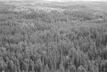
Figure 3: Forest communities dominated by jack pine in the eastern portion of the conservation reserve; sandy beach areas and shore fens (surrounding lakes) are common features of Wagong Lake Forest Conservation Reserve.
(Photo by J. Young; September, 2003)

A majority of the conservation reserve was affected by the Mississagi forest fire in 1948. Natural succession has resulted in relatively even-aged forest communities between 30 and 59 years of age, with pockets of older stands (120+ years) in lowland areas, particularly between Maule and Rover lakes. The old-growth red pine stand along the eastern shore of Wagong Lake has been aged at more than 140 years (Crins 1996).
Stocking
More than 20% of Wagong Lake Forest Conservation Reserve is marine-based, consisting of Maule, Rover, Wagong and Dodge lakes, with several smaller unnamed lakes and creek systems interspersed throughout the site. Additionally, the centre of the West Abinette River forms the eastern boundary of the site. The lakes and creeks are headwaters for the Mississagi River system, which eventually flows into Lake Huron. Wagong Lake is part of a coldwater ecosystem and is designated as a B1 lake trout lake (OMNR 2004a). Whitefish, northern pike, yellow perch (Perea flavescens) and common sucker (Catostomus spp.) are additional fish species supported by Wagong Lake. Northern pike can also be found in Dodge, Rover and Maule lakes. All of the lakes within the conservation reserve contain natural fish populations and no stocking has been documented (Young 2004).
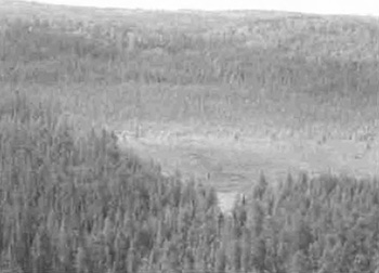
Wetlands increase the diversity of this site and include small shore fens, thicket swamps, open water marshes, semi-treed bogs, treed bogs, and conifer swamps (see Figure 4). The largest conifer swamp extends west of Rover Lake and south to Maule Lake. According to Burkhardt et al. (2004), wetland complexes around Wagong Creek and the unnamed lake northeast of Wagong Lake, have been identified as suitable moose (Aices alces) aquatic habitats. Several beaver (Castor Canadensis) dams, identified by Ministry of Northern Development and Mines, may have contributed to the formation of wetlands in this site.
According to the Ontario Breeding Bird Atlas (OBBA; www.birdsontario.org), this site is located within Region 34, mostly within survey square number 17LN52 and partially within squares 17LN42, 17LN41 and 17LN51. Although there has only been one entry for blocks encompassing the conservation reserve, adjacent squares have identified between 53 and 60 breeding bird species. Confirmed breeding evidence includes the common goldeneye (Bucephala clangula), hairy woodpecker (Picoides villosus), northern flicker (Colaptes auratus), white-throat sparrow (Zonotrichia albicollis) and osprey (Pandion haliaetus). An osprey nesting site was identified during aerial reconnaissance in 2002. Recent activity for this nest requires confirmation.
Figure 4: Wetlands are a dominant feature within this site. Aerial view of conifer swamp, east of Dodge Lake.
(Photo by J. Young; September, 2003)
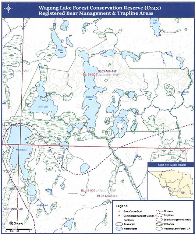
Two registered trapline areas encompass Wagong Lake Forest Conservation, and recent records confirm the presence of beaver, mink (Mustela vision), marten (Martes americana), otter (Lontra Canadensis), fisher (Martes pennanti), raccoon (Lontra canadensis), weasel (Martes sp.), muskrat (Ondatra zibethicus), lynx (Lynx lynx), red squirrel (Tamiasciurus hudsonicus) and red fox (Vulpes vulpes). Additionally, this site is covered by two bear management areas. Please refer to sections 6.3.3 Commercial Fur Trapping and 6.3.4 Bear Management Areas for more details.
More detailed analysis of life science values is available in the Life Science Inventory Report for Wagong Lake Forest Conservation Reserve (Burkhardt et. al 2004).
5.4 Recreational values
Wagong Lake Forest Conservation Reserve supports a variety of recreational activities and offers potential opportunities for a number of others. The remoteness of the site provides the avid fisherman or hunter with wilderness that can only be accessed by small aircraft, waterway or trekking.
Moule, Rover and Dodge lakes are designated tourism lakes (OMNR 1983); all of which are equipped with commercial outpost camps. Boat caches and docks exist on Wagong and Dodge lakes and an unnamed lake located between the two (see Figure 5). It is thought that they are utilized by outfitters and their clients. No formal trails or portages have been identified within the conservation reserve, although aerial reconnaissance photos from 2003 depict small clearings, suggesting that portage trails may exist from the east shore of Wagong to the west shore of the unnamed lake, and further onto Dodge Lake.
Moule, Rover, Wagong and Dodge lakes provide anglers with opportunities for whitefish, northern pike, yellow perch and common sucker fishing. Additionally, Wagong has been classified as a B1 lake trout lake and is managed exclusively for lake trout (OMNR 2004a). Both big and small game hunting occurs within the conservation reserve and includes moose, deer (Odocoileus virginianus), bear (Ursus americanus) and ruffed grouse (Bonasa umbellus).
Figure 5: Aerial view of boat cache on unnamed lake between Wagong and Dodge lakes.
(Photo by J. Young; September, 2003)
The wetlands, streams, lakes, bedrock outcroppings and naturally regenerated forests of Wagong Lake Forest Conservation Reserve additionally provide recreational potential for bird watching, nature appreciation and photography. As well, canoeing and kayaking may be enjoyed in this remote area. In the absence of formal campsites within the conservation reserve, sandy beaches provide ideal camping and/or picnic areas.
5.5 Cultural values
This site falls within the Robinson-Huron Treaty area. A past history of trapping in this surrounding area has been identified by First Nations. It is likely that the waterways within this conservation reserve were used in trapping and fur trade.
5.6 Research values
The Ontario Breeding Bird Atlas (OBBA; www.birdsontario.org) is a collaboration of survey data for breeding birds across the province. Volunteers survey 10 km2 areas assessing bird species and breeding populations. Wagong Lake Forest Conservation Reserve falls within survey square number 17LN52 and partially within squares 17LN42, 17LN41 and 17LN51 of Region 34. To date there has only been one confirmed entry for blocks encompassing this site, likely due to its remoteness and difficult accessibility. Surveying for the OBBA will be completed in 2005.
5.7 Site condition
The area encompassed by Wagong Lake Forest Conservation Reserve is described as having low human disturbance; although when one observes the area initially, it appears to be pristine (Burkhardt et al. 2004). Access to this site is restricted due to its location; surrounded by the Hinkler Road Enhanced Management Area, the site can only be accessed via small aircraft, waterway or by wilderness trekking. The absence of roads, private cottages and campsites within the site account for its low degree of human disturbance. Developments within the conservation reserve have been established by land use permit (LUP) holders, including half hectare commercial outpost camps on Maule, Rover and Dodge lakes. Several docking structures and boat caches exist on Wagong, Dodge, and the small unnamed lake located between the two (see Figure 6).
Most of Wagong Lake Forest Conservation Reserve was affected by two fires in the 1940s. Of the larger forest fires, the "Mississagi '48" was one of the most devastating in Ontario’s history. Small patches of forest communities in the site were unaffected by the fires, allowing some stands to reach beyond 120 years, while the majority of the conservation reserve reflects natural succession. Regenerated forest communities are dominated by jack pine, trembling aspen, black spruce and white birch. A smaller forest fire may have occurred recently in the eastern portion of the conservation reserve. This is supported by an aerial reconnaissance survey in 2003, which revealed a younger jack pine dominated stand (Burkhardt et al. 2004). Additional research is required to confirm that a fire has occurred recently in this area.
Immediately south of the conservation reserve, tree harvesting operations have occurred since the 1980s and more recent cutting has occurred east of Maule Lake. During a 2003 flight, Ministry of Natural Resources' staff identified areas within the present day conservation reserve that have been affected by recent cutting (East of Maule Lake) including, patches of young (0 to 29 years), unstocked forest communities within this area. More detailed analysis of forest communities is available in the Life Science Inventory Report for Wagong Lake Forest Conservation Reserve (Burkhardt et al. 2004).
Figure 6: Old dock and small clearing on eastern shore of Wagong Lake.
(Photo by J. Young; September, 2003)
6.0 Management guidelines
All management guidelines in this SCI are based on direction contained in the LUS (OMNR 1999) and associated policy clarification statements (OMNR 2000). The management guidelines outlined in this section are specific to Wagong Lake Forest Conservation Reserve and are intended to protect the site’s unique values. The guidelines in this document may be subject to change and may be amended as necessary. If a conflict between management guidelines exists, the conservation reserve will be managed to protect the integrity of its natural values, while permitting compatible land use activities (OMNR 1997a).
Proposed new uses and/or development, as well as research and education activities will be reviewed on a case-by-case basis. Before new proposals can be permitted, the Test of Compatibility (see Appendix C) must be passed as well as consideration of cultural values according to Conserving a Future for our Past: Archaeology, Land Use Planning & Development in Ontario, Section 3 (Ministry of Culture 1998). In addition, all new proposals are subject to applicable Environmental Assessment Act (R.S.O. 1990, Chapter E.18) requirements.
The following management strategies have been devised to achieve the goal and objectives of the SCI for Wagong Lake Forest Conservation Reserve. A summary table of the management guidelines for this site can be found in Appendix D. For the most up-to-date version of this summary table, please refer to the Crown Land Use Policy Atlas, located on the Internet at /page/crown-land-use-policy-atlas, or contact your local Ministry of Natural Resources office. The Crown Land Use Policy Atlas is a consolidation of existing local land use policies for Crown lands within the OLL planning area, an area that covers 45% of the province, extending from Lake Simcoe in the south to the Albany River in the north.
6.1 Industrial activities
6.1.1 Commercial timber harvest
The total area contained within this conservation reserve (2,381 ha) has been withdrawn from the Northshore Sustainable Forest License area and no commercial timber harvesting will be permitted. Please refer to Section 6.4.3 for information regarding non-commercial wood harvesting.
6.1.2 Mining and exploration
There are no existing mining claims or leases within this conservation reserve. Mining and surface rights have been withdrawn from staking under the Mining Act (RSO 1990 Chapter M.14). Mineral exploration is not permitted.
6.1.3 Extraction of peat, soil, aggregate and other material
Extraction of peat, soil, aggregate and other material is not permitted.
6.1.4 Energy generation
New hydropower developments are not permitted within Wagong Lake Forest Conservation Reserve. Wind power developments are prohibited under the Public Lands Act, Procedure PL 4.10.04 "Wind Power Development on Crown Land" (OMNR 2004c).
6.2 Existing and proposed development
6.2.1 Transportation corridors
6.2.1.1 Roads
According to the LUS (OMNR 1999), new roads for resource extraction will not be permitted except for those identified in Forest Management Plans prior to March 31, 1999. No new or existing roads for resource extraction were identified. Development of new roads will not be permitted.
6.2.1.2 Trails
The existence of trails within the conservation reserve has not yet been confirmed.
Any proposed new trails will be subject to the Test of Compatibility (see Appendix C) and applicable Ministry of Natural Resources' policies and procedures. Trail development in low-lying areas, and wetlands will be discouraged, as will trail development over shallow soils on rock outcrops. All new trail heads and trail routes must be recorded using new technologies (i.e. global positioning systems) to ensure an accurate record of the location of the feature. This location information must be provided to the Sault Ste. Marie District, Ministry of Natural Resources.
6.2.2 Other corridor development/maintenance
No communication, energy transmission, or other non-road corridors are located within this conservation reserve. New corridor developments will be actively discouraged. Proposals for new corridors will be subject to the Test of Compatibility (see Appendix C) and applicable Ministry of Natural Resources' policies and procedures.
6.2.3 Natural heritage appreciation facilities/recreational structures
There are currently no existing authorized natural heritage appreciation facilities or recreational structures (i.e. boardwalks, bird viewing platforms, kiosks, ski shelters, or interpretative signs).
New natural heritage appreciation facilities and recreation structures are permitted, subject to the Test of Compatibility (see Appendix C) and applicable Ministry of Natural Resources' policies and procedures.
6.2.4 Land disposition
Sale of Crown lands is not permitted, except for those situations described in the policy clarification tables (OMNR 2000).
Presently, three land use permits (LUPs) exist within this conservation reserve. New leases or LUPs may be issued for approved public uses (i.e. not for private recreation camps), subject to the Test of Compatibility (see Appendix C) and applicable Ministry of Natural Resources' policies and procedures. These leases/permits will not be sold but may be eligible for enhanced tenure or transfer.
Enhanced tenure is defined as anything beyond the term and form of current tenure. All requests for transfer or enhanced tenure will be subject to the following screening criteria:
- Is the transfer or enhanced tenure consistent with the conservation reserve’s land use intent, which is the protection and enhancement of the site’s natural, recreational and cultural values?
- Is it consistent with the land disposition policies outlined in the District Land Use Guidelines, the Crown Land Use Policy Atlas, this SCI and any other applicable document?
- Does it adversely affect the values as identified in Section 5.0, and/or conflict with other uses?
- Is land needed by the Crown to protect significant natural or recreational values outlined in this SCI?
- Does the transfer or enhanced tenure clash with traditional Aboriginal uses, land claims or agreements?
- Are all rents, taxes, fees, rates or charges paid up for the existing LUP or lease?
6.3 Commercial activities
6.3.1 Commercial bait harvesting
No active commercial bait harvest operations currently exist within this conservation reserve. However, Laughren and Lawlor townships are allocated to bait harvesting operations. New operations can be considered subject to the Test of Compatibility (see Appendix C) and applicable Ministry of Natural Resources' policies and procedures.
Under Public Lands Act PL 3.03.08 "Buildings for Bait Harvesting Management" (OMNR 2002), cabins for the purposes of bait harvesting may be constructed on Crown land. However, such buildings should be avoided within this conservation reserve.
6.3.2 Commercial fishing
There are no commercial fisheries within this conservation reserve. New operations may be considered subject to the Test of Compatibility (see Appendix C) and applicable Ministry of Natural Resources' policies and procedures.
6.3.3 Commercial fur trapping
Most of Wagong Lake Conservation Reserve is within Registered Trapline Area BL044, and the southern part of Maule Lake is covered by BL046 (see Appendix A, Map 2). Both trapline areas are currently allocated to head trappers. If a head trapper surrenders a registered trapline, or the head trapper’s privileges are revoked, the registered trapline may be transferred to another trapper following allocation procedures. If the registered trapline is not transferred in due course, or remains unallocated for a significant period of time, reallocation of the trapline may occur following applicable district screening processes.
The establishment of new trapline trails will be considered following the procedure and criteria for new trails as outlined in Section 6.2.1.2. No trap cabins currently exist within the Wagong Lake Forest Conservation Reserve.
6.3.4 Bear Management Areas
Bear Management Area (BMA) BL-28-029 covers a majority of the conservation reserve (see Appendix A, Map 2). The southern half of Maule Lake is covered by BL-38-033. BMAs within this conservation reserve may be permitted in cases where the current operator sells their bear hunting business to another operator and the BMA transfer is approved. If an operator surrenders the BMA or the BMA is revoked, reallocation of the BMA may occur following applicable district screening processes.
6.3.5 Commercial food collection
No commercial food harvesting ventures exist within the conservation reserve. Any new ventures require permits issued by the Ministry of Natural Resources, and will be subject to the Test of Compatibility (see Appendix C) and applicable Ministry of Natural Resources' policies and procedures.
6.3.6 Commercial non-timber forest products
Commercial harvesting of non-timber forest products is not consistent with the intent of the conservation reserve and will not be approved.
6.3.7 Outpost camps/main base lodges
Currently, three outpost camps exist within the conservation reserve on Moule, Rover and Dodge lakes. New outpost camps and main base lodges may be permitted, subject to the Test of Compatibility (see Appendix C) and applicable Ministry of Natural Resources' policies and procedures.
6.4 Non-commercial activities
6.4.1 Nature appreciation/recreation activities
The enhanced management area surrounding this conservation reserve and the absence of roads/trails providing access to and/or within the site, limits the occurrence of recreational and nature appreciation activities. Off-trail hiking, cross-country skiing, snowshoeing, and other nonmotorized activities will be permitted within this conservation reserve. However, should the impact of these activities degrade the landscape, the Ministry of Natural Resources will re-evaluate these permitted uses and decide upon a new strategy for this site. New trails to support these activities may be considered. Please refer to Section 6.2.1.2 for more details related to trail development.
6.4.2 Camping
There are no maintained campsites or campgrounds within this conservation reserve, although sandy beaches have been identified as potential tenting areas. Crown land camping policies apply, unless significant adverse effects on protected values necessitate further planning and management for this activity. Campers should avoid sensitive areas within the conservation reserve (i.e. Wetlands and shallow soil areas).
6.4.3 Non-commercial consumptive resource use
Cutting of trees for non-commercial purposes may be authorized via a permit issued by the local Ministry of Natural Resources' office, subject to review and determination of the impact that such cutting would have on the values identified in Section 5.0. Such permits are intended only for land use permit holders within the conservation reserve who do not have road access to their property and have no alternate wood source outside of the conservation reserve. This permit is intended to cover fuel wood, dock stringers, and other occasional small scale uses.
Non-commercial harvesting of non-timber forest products such as berries and mushrooms can occur provided the values of the site, identified in Section 5.0- State of the Resource, are not jeopardized.
6.4.4 Hunting and fishing
Hunting and fishing are traditional activities within this conservation reserve. In conjunction with current hunting and/or fishing regulations and conservation reserve policy, both hunting and fishing are permitted to continue.
6.4.5 ATV and snowmobile use
The existence of trails within the conservation reserve has not yet been confirmed. Please refer to Section 6.2.1.2 for more information on trails. In general, off-trail use of ATVs and snowmobiles is not permitted. However, off-trail use is permitted for licensed trappers to access their traplines and for licensed bait harvest operators to conduct bait harvest operations. Off-trail ATV and snowmobile use are also permitted for the direct retrieval of big game by hunters. In all these cases, off-trail use is only permitted provided the protection of the site’s values is not compromised. Should the impact of off-trail ATV and snowmobile use degrade the landscape; the Ministry of Natural Resources will re-evaluate these permitted uses and determine a new strategy.
6.4.6 Watercraft use
More than 20% of this conservation reserve is marine-based. Watercraft usage, including motorized boats, canoes and kayaks, is permitted to continue. Individuals are encouraged to use safe boating practices and to avoid disturbance of sensitive features (i.e. wetlands). Should the impact of watercraft degrade the marine portion of the conservation reserve, the Ministry of Natural Resources will re-evaluate these permitted uses and determine a new strategy.
6.5 Resource management activities
Resource management activities refer to those tools used to protect and enhance the values of this conservation reserve. Some management activities may require the use of intrusive techniques. Under normal circumstances, some of these techniques would not be permitted to occur in the conservation reserve; however, if they are found to be necessary, they may be applied under controlled conditions, to achieve a desired result. Infrastructure such as trails and buildings may need to be constructed to support activities such as prescribed burns, forest regeneration, wildfire control, and insect and disease control. Activities described in this section will be deemed acceptable if the ultimate outcome is in compliance with the management intent for this conservation reserve.
6.5.1 Insect and disease control
This conservation reserve will be maintained in as natural a state as possible. Insect and disease control measures should only be considered if the identified values are significantly threatened.
6.5.2 Fire management
The Ministry of Natural Resources recognizes fire as an essential process fundamental to the ecological integrity of conservation reserves. In accordance with existing conservation reserve policy and the Forest Fire Management Strategy for Ontario (OMNR 2004b), forest fire protection will be carried out as on surrounding lands.
Whenever feasible, the Ministry of Natural Resources' fire program will endeavor to use "light on the land" techniques, which do not unduly disturb the landscape, in this conservation reserve. Examples of light on the land techniques may include limiting the number of trees felled during the fire response efforts.
Opportunities for prescribed burning to achieve ecological or resource management objectives may be considered. These management objectives will be developed with public consultation prior to any prescribed burning, and will be reflected in the document that provides fire management direction for this conservation reserve. Plans for any prescribed burning will be developed in accordance with the Ontario Ministry of Natural Resources Prescribed Burn Planning Manual (1997b) and the Environmental Assessment Act (R.S.O. 1990, Chapter E.18).
6.5.3 Fish and wildlife management
New fish and/or wildlife management activities may be considered, but will require the approval of either a separate fish/wildlife management plan, which must be referenced in this SCI, and/or an amendment to this SCI to include specific management prescriptions. New fish and wildlife management activities are also subject to the Test of Compatibility (see Appendix C) and applicable Ministry of Natural Resources' policies and procedures.
6.5.4 Vegetation management
New vegetation management activities may be considered but will require the approval either a separate vegetation management plan, which must be referenced in this SCI, and/or an amendment to this SCI to include specific management prescriptions. New vegetation management activities are also subject to the Test of Compatibility (see Appendix C) and applicable Ministry of Natural Resources' policies and procedures.
6.5.5 Forest renewal
Preference will be given to natural regeneration following any disturbance in the conservation reserve. In some cases, regeneration may be artificially assisted when It is deemed appropriate to mitigate against human disturbances (i.e. illegal occupation and trespass).
6.6 Research
Scientific research is encouraged, by qualified individuals or institutions, that contributes to a better understanding of the natural and cultural values protected by this conservation reserve, or that advances the protection, planning and management of these values. The Sault Ste. Marie District Planner should be contacted for Information on research and/or monitoring opportunities within this conservation reserve. Proposals to conduct research should be directed to the Northshore Area Supervisor, Ministry of Natural Resources, Sault Ste. Marie District Office, and will be subject to the Test of Compatibility (see Appendix C) and applicable Ministry of Natural Resources' policies and procedures. Any site that is disturbed during research activities is to be rehabilitated as closely as possible to its original condition. Collecting may only be permitted as part of an authorized research project and may be subject to appropriate permits and conditions.
Existing Forest Resource Inventory surveys and approved resource monitoring activities are permitted to continue.
6.7 Marketing
No active marketing of this conservation reserve by Sault Ste. Marie District, Ministry of Natural Resources is anticipated.
6.8 First Nations
Traditional activities and Aboriginal rights, as defined in the Robinson-Huron Treaty and other applicable legislation, will not be affected within or by the boundaries of this conservation reserve. Any First Nation land claims within this area will be addressed according to appropriate Ministry of Natural Resources' procedures. When possible, the Ministry of Natural Resources will work with the Ontario Ministry of Culture and/or any First Nation community within the Robinson-Huron Treaty area to identify archaeological sites to be protected.
7.0 Recommendations
7.1 Additions to the reserve
Many of the site’s key values extend beyond Wagong Lake Forest Conservation Reserve’s boundary onto surrounding Crown land. It is recommended that the northeast boundary of the site be extended to incorporate a large wetland complex, and the headwaters to the Wagong Creek/Lake system which serve as cold water fisheries. To improve the boundary, the northwest corner should be extended to include a portion of a creek system within Gisborn and Gilberston townships. This would also provide protection for a portion of a large wetland (Burkhardt et al. 2004).
7.2 Future needs and considerations
The values protected by this site should be considered in land use management activities on adjacent properties to ensure sufficient protection of the site’s core values.
Table 3 (on the following page) highlights future needs and considerations for Wagong Lake Forest Conservation Reserve.
7.3 Monitoring
Periodic monitoring of human activities and/or their impacts within this conservation reserve will be conducted. A schedule for cursory field monitoring will be identified within the District’s annual compliance plan and an IFM (Integrated Field Monitoring) inspection report will be filed at the Sault Ste. Marie District Office. The Northshore Area Supervisor will oversee these activities. In addition, Conservation Officers will complete periodic compliance monitoring to ensure the protection mandate is maintained. If at any time human activities are deemed to be negatively impacting the protected features, the activities will be reviewed and measures taken to mitigate any disturbance.
Approved inventory, monitoring, assessment, or research activities that are compatible with protection objectives are encouraged. Any area that is disturbed during research activities is to be rehabilitated as closely as possible to its original condition. The Northshore Area Supervisor may apply additional conditions.
Table 3. Future needs and considerations for Wagong Lake Forest Conservation Reserve.
| Future needs/considerations | Details |
|---|---|
| Detailed earth science inventory | The Northeast Region should complete the final stage of the life science inventory. Completion of the final stage of life science inventory includes an assessment of the site’s significance and its contribution to the parks and protected areas program. |
| Detailed earth science inventory | The Northeast Region should complete a detailed version of the earth science inventory, including ground reconnaissance surveys and an assessment of the site’s significance and contributions to the parks and protected areas program. |
| Trail inventory | Determine location, extent and condition of any existing trails within the conservation reserve; ensure all trail heads and routes are recorded using Global Positioning Systems (GPS). |
| Flora and fauna assessment | Efforts should be made to identify any species at risk (i.e. bald eagles) that may found within the conservation reserve. This would ensure that protective measures could be in place to protect and sustain such populations. |
| Boundary marking | Vectored boundaries should be clearly marked for long-term recognition, so that the site’s core values are protected from surrounding land use activities. |
| Signage | Sign should be erected on Cypress Lake Road to identify it as a restricted access/non-public road. |
| Partnership development | Efforts should be made to work with partners (such as Aboriginal communities, the Ontario Forest Research Institute (OFRI), Sault College of Applied Arts and Technology) to gather baseline data on this site to assist with future monitoring and inspection activities. |
| Winter recreation assessment | Efforts should be made during winter months to further assess the intensity of ice-fishing, snowmobiling and other winter recreation activities occurring within the conservation reserve. |
| Education | Educate public who use Crown land features in/around this conservation reserve about the site’s natural heritage; protection intent of the CR; permitted uses; etc. |
| Funding | Efforts should be made to obtain funding to support the above listed items, including monitoring, assessment, and inspection requirements for this site. |
8.0 Implementation, review and revisions
8.1 Responsibility
The Sault Ste. Marie District will be responsible for implementing the management policies and guidelines for Wagong Lake Forest Conservation Reserve. The primary role will be to provide public information and compliance monitoring to ensure adherence to current policies and guidelines.
8.2 Review and revisions
The Wagong Lake Forest Conservation Reserve SCI will be reviewed every five years by the District Planner to confirm and update the information in this document. Revisions to this document will be subject to requirements as specified in the Environmental Assessment Act (R.S.O. 1990, Chapter E.1B). If changes in management direction are needed at any time, the significance of the changes will be evaluated. Minor amendments to the plan that do not alter the overall protection objectives may be considered and approved by the Area Supervisor without further public consultation. All minor amendments to the SCI will be documented in Appendix F. In assessing major amendments, the need for a more detailed Resource Management Plan (RMP) will first be considered. Where a RMP is not considered necessary or feasible, a major amendment to management direction may be considered with public consultation. Major amendments will be recommended by the District Manager and approved by the Regional Director, and will follow the appropriate guidelines (OMNR 2001b).
Literature cited
Burkhardt, B., King, L., Longyear, S. 2004. Wagong Lake Forest Conservation Reserve (C243), Life Science Checksheet - Step 2. Unpublished information. Ontario Ministry of Natural Resources.
Campbell, G. Area Forester, Ministry of Natural Resources. Personal Communication. October, 2004.
Crins, W.J. 1996. Life Science Gap Analysis for Site District 4E-3. Unpublished information. Ontario Ministry of Natural Resources.
Crins, W.J. and P.W.C. Uhlig, 2000. Ecoregions of Ontario: Modification to Angus Hills' Site Regions and Site Districts - Revisions and Rationale.
Hills, G.A. 1959. A Ready Reference for the Description of the Land of Ontario and its Productivity. Preliminary Report. Ontario Department of Lands and Forests. Maple. Ontario.
Kristjansson, F.J. 2004. Draft Earth Science Inventory Checklist, Wagong Lake Forest (C243). Unpublished information. Ontario Ministry of Natural Resources.
Ministry of Culture. 1998. Conserving a Future for Our Past: Archeology Land Use Planning and Development in Ontario. Ministry of Culture, Heritage and Libraries Branch - Heritage Operations Unit. Published by the Ontario Archaeological Society. Toronto, Ontario.
Ontario Breeding Bird Atlas - Bird Studies Canada. [Accessed: October 7, 2004] www.birdsontario.org. Copyright by Bird Studies Canada and bsc-eoc.org.
Ontario Ministry of Natural Resources. 1983. Ministry of Natural Resources Blind River District Land Use Guidelines. Queen’s Printer for Ontario: Ontario, Canada.
Ontario Ministry of Natural Resources. 1996. Mississagi Provincial Park - Background Information. Unpublished information.
Ontario Ministry of Natural Resources. 1997a. Conservation Reserves. Lands and Waters Branch Policy. Public Lands Act, PL 3.03.05. Date Issued: February 11, 1997.
Ontario Ministry of Natural Resources. 1997b. Prescribed Burn Planning Manual. AFFMB Publication No. 313. Ontario Ministry of Natural Resources.
Ontario Ministry of Natural Resources. 1999. Ontario’s Living Legacy Land Use Strategy. Queen’s Printer for Ontario: Ontario, Canada.
Ontario Ministry of Natural Resources. 2000. Policy Clarification for Conservation Reserves. Unpublished document. September 2000.
Ontario Ministry of Natural Resources. 2001a. Forest Information Manual. Queen’s Printer for Ontario: Toronto, Ontario.
Ontario Ministry of Natural Resources. 2001b. Procedures for the Amendment of Ministry of Natural Resources Land Use Direction. Ontario Ministry of Natural Resources.
Ontario Ministry of Natural Resources. 2002. Buildings for Bait Harvesting Management. Public Lands Act, PL 3.03.08.
Ontario Ministry of Natural Resources. 2004a. Crown Land Use Policy Atlas - Policy Report, C243 Wagong Lake Forest. [Accessed: October 25, 2004] http://crownlanduseatlas.mnr.gov.on.ca/pdfs/C243.pdf
Ontario Ministry of Natural Resources. 2004b. Forest Fire Management Strategy for Ontario. Queen’s Printer for Ontario: Ontario, Canada.
Ontario Ministry of Natural Resources. 2004c. Wind Power Development on Crown Land. Lands and Waters Policy Branch. Public Lands Act, PL 4.10.04. Date Issued: January 27, 2004.
R.S.O. 1990, Chapter E.18. Environmental Assessment Act. [Accessed: September 15, 2003] http://www.e-laws.gov.on.ca/DBLaws/Statutes/English/90e18_e.htm.
R.S.O. 1990, Chapter M.14. Mining Act. [Accessed: September 15, 2003] http://www.elaws.gov.on.ca/DBLaws/Statutes/English/90m14_e.htm. [link not active]
Thompson, J. 2001. Northeast Region Guidelines on the Planning Process for Conservation Reserves: Statements of Conservation Interest and Resource Management Plan. Unpublished information. Ontario Ministry of Natural Resources.
Young, J. 2004. Recreation Inventory Report - Wagong Lake Forest Conservation Reserve (C243). Unpublished information. Ontario Ministry of Natural Resources.
Appendix A: Wagong Lake Forest Conservation Reserve Maps
Map 1: Recreational Values of Wagong Lake Forest Conservation Reserve
Enlarge Map 1: Recreational Values of Wagong Lake Forest Conservation Reserve
Map 2: Registered Bear Management and Trapline Areas of Wagong Lake Forest Conservation Reserve
Map 3: Landforms in Conservation Reserve, according to provincial landform coverage.
(Source: Burkhardt et al. 2004. Life Science Checksheet - Step 2)
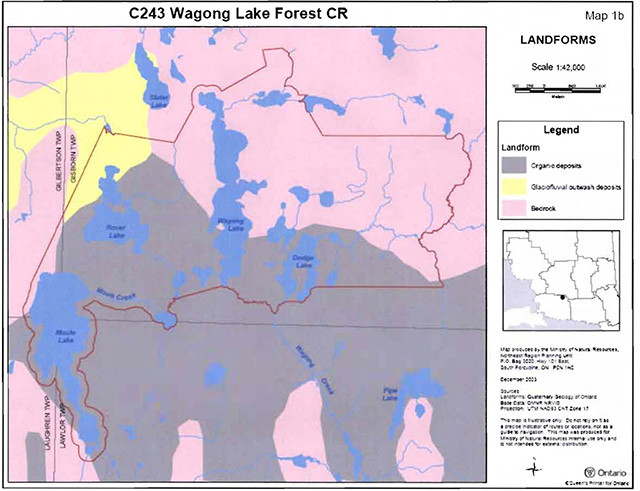
Enlarge Map 3: Landforms in Conservation Reserve, according to provincial landform coverage.
Map 4: Forest communities in Wagong Lake Forest Conservation Reserve.
(Source: Burkhardt et al. 2004. Life Science Checksheet - Step 2)
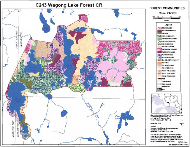
Enlarge Map 4: Forest communities in Wagong Lake Forest Conservation Reserve.
Map 5: Old-Growth Forest Communities in Wagong Lake Forest Conservation Reserve.
(Source: Burkhardt et al. 2004. Life Science Checksheet - Step 2)
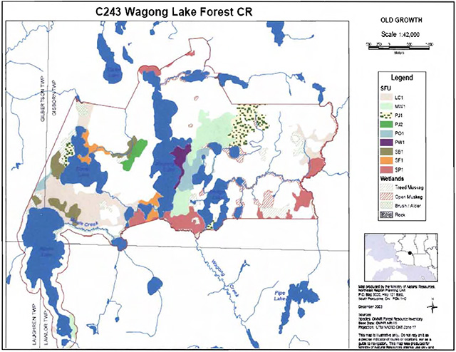
Enlarge Map 5: Old-Growth Forest Communities in Wagong Lake Forest Conservation Reserve.
Map 6: Wetlands In Wagong Lake Forest Conservation Reserve.
(Source: Burkhardt et al. 2004. Life Science Checksheet - Step 2)
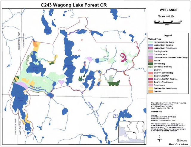
Enlarge Map 6: Wetlands In Wagong Lake Forest Conservation Reserve.
Appendix B: Wagong Lake Forest Conservation Reserve photos
Photo 1: Aerial view of small unnamed lake and wetland between Wagong and Dodge lakes.
(Photo by J. Young; September, 2003)
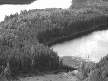
Photo 2: View of east portion of Wagong Lake Forest Conservation Reserve. Forest communities are dominated by jack pine (Pinus banksiana), black spruce (Picea mariana) and trembling aspen (Populus tremuloides).
(Photo by OMNR; September 2003)
Appendix C: Test of Compatibility
Appendix D: Summary of Permitted Uses
The following Policy Report was obtained from the Crown Land Use Policy Atlas website during completion of this SCI (February, 2005). Changes may have been made to this policy report since that time. For the most recent version of this policy report, please refer to the Crown Land Use Policy Atlas on the Internet at /page/crown-land-use-policy-atlas or contact your local Ministry of Natural Resources office.
Crown Land Use Policy Atlas - Policy Report
Wagong Lake Forest
Updated: June 29, 2004
Identification:
ID: C243
Area Name: Wagong Lake Forest
Area (ha): 2,381
Designation: Conservation Reserve (Ontario’s Living Legacy)
MNR District(s): Sault Ste. Marie
Description:
This natural heritage area contains forests dominated by jack pine, trembling aspen and black spruce, including some older stands of these forest types. The site also contains white birch stands plus a small old growth red pine stand on the east shore of Wagong Lake. This is the best known example of its vegetation on this landform of low sand and gravel hills (glacial outwash) in Site District 4E-3.
Wagong Lake Forest was regulated as a conservation reserve on April 6, 2001.
Land use intent:
Management of this area is also governed by the general policies contained in the Land Use Strategy (1999).
Management direction:
Those uses and management activities not listed in the following table are governed by existing conservation reserve policy. Over time the management direction will be elaborated in a Statement of Conservation Interest or Resource Management Plan. Any new uses, and commercial activities associated with conservation reserves will be considered on a case by case basis and they must pass a test of compatibility to be acceptable.
Compatibility is normally determined through a planning process
Commercial activities
| Activity | Permitted | Guidelines |
|---|---|---|
| Aggregate extraction: | No | |
| Bait fishing - Existing: | Yes | Existing use permitted to continue, unless there are significant demonstrated conflicts. |
| Bait fishing - New: | Maybe | New operations can be considered, subject to the "test of compatibility". |
| Commercial fishing - Existing: | Yes | Existing use permitted to continue, unless there are significant demonstrated conflicts. |
| Commercial fishing - New: | Maybe | New operations can be considered, subject to the "test of compatibility" |
| Commercial fur harvesting - Existing: | Yes | Existing use permitted to continue unless there are significant demonstrated conflicts. Existing trap cabins can continue new cabins are not permitted. |
| Commercial fur harvesting - New: | Maybe | New operations can be considered, subject to the "test of compatibility''. |
| Commercial hydro development: | No | |
| Commercial timber harvest: | No | |
| Commercial tourism - Existing: | Yes | Existing authorized facilities can continue unless there are significant demonstrated conflicts. |
| Commercial tourism - New: | Maybe | New tourism facilities can be considered during the planning for an individual reserve. |
| Bear hunting by non-residents (guided) - Existing: | Yes | Existing authorized operations permitted to continue. |
| Bear hunting by non-residents (guided) - New: | No | New operations not permitted. |
| Outfitting services - Existing: | Yes | Existing authorized operations permitted to continue. |
| Outfitting services - New: | Maybe | New operations can be considered during the planning for an individual reserve. |
| Outpost camps - Existing: | Yes | Existing authorized operations permitted to continue. |
| Outpost camps - New: | Maybe | New facilities can be considered during the planning for an individual reserve. |
| Resorts/lodges - Existing: | Yes | Existing authorized facilities permitted to continue. |
| Resorts/lodges - New: | Maybe | New facilities can be considered during the planning for an individual reserve. |
| Energy transmission and communications corridors - Existing: | Yes | These facilities should avoid conservation reserve lands wherever possible. |
| Energy transmission and communications corridors - New: | No | |
| Food harvesting (commercial) - Existing: | Maybe | |
| Food harvesting (commercial) - New: | Maybe | |
| Mineral exploration and development: | No | |
| Peat extraction: | No | |
| Wild rice harvesting - Existing: | Yes | |
| Wild rice harvesting - New: | Maybe |
Land and resource management activities
| Activity | Permitted | Guidelines |
|---|---|---|
| Crown land disposition - Private use: | Maybe | Sale of lands is not permitted, except for minor dispositions in support of existing uses (e.g. reconstruction of a septic system). Renewals of existing leases and land use permits are permitted. Requests for transfer of tenure will be considered in the context of the Statement of Conservation Interest or Resource Management Plan. New leases or land use permits permitted for approved activities. Tourism facilities can apply to upgrade tenure from LUP to lease. |
| Crown land disposition - Commercial use: | Maybe | Sale of lands is not permitted, except for minor dispositions in support of existing uses (e.g. reconstruction of a septic system). Renewals of existing leases and land use permits are permitted. Requests for transfer of tenure will be considered in the context of the Statement of Conservation Interest or Resource Management Plan. New leases or land use permits permitted for approved activities. Tourism facilities can apply to upgrade tenure from LUP to lease. |
| Fire suppression: | Yes | Fire suppression policies are similar to adjacent Crown lands, unless alternative fire policies have been developed through a planning process. |
| Fish habitat management: | Maybe | Fish Stocking Conservation Reserves policy indicates that "featured species management" may be permitted. |
| Fish stocking: | Maybe | Conservation Reserves policy indicates that "featured species management" may be permitted. |
| Insect/disease suppression: | Maybe | |
| Inventory/monitoring: | Yes | |
| Prescribed burning: | Maybe | |
| Roads (resource access) - Existing: | Yes | Existing roads can continue to be used. Continued use will include maintenance and may include future upgrading. |
| Roads (resource access) - New: | Maybe | New roads for resource extraction will not be permitted, with the exception of necessary access to existing forest reserves for mineral exploration and development. |
| Vegetation management: | Maybe | Conservation Reserves policy Indicates that Featured Species Management and Natural Systems Management may be permitted. Vegetation management can be considered in a planning process. |
| Wildlife population management: | Maybe |
Science, education and heritage appreciation
| Activity | Permitted | Guidelines |
|---|---|---|
| Collecting: | No | |
| Historical appreciation: | Yes | |
| Nature appreciation: | Yes | |
| Photography and painting: | Yes | |
| Research: | Yes | |
| Wildlife viewing: | Yes |
Recreation activities and facilities
| Activity | Permitted | Guidelines |
|---|---|---|
| All-terrain vehicle use - On trails: | Yes | Existing use permitted to continue where it does not adversely affect the values being protected. |
| All-terrain vehicle use - Off trails: | No | ATV use off trails is not permitted except for direct retrieval of game. |
| Campgrounds: | Maybe | |
| Food gathering: | Yes | |
| Horseback riding (trail): | Yes | Existing use on trails permitted. |
| Hunting: | Yes | |
| Mountain bike use: | Yes | Existing use on trails permitted. |
| Motor boat use - Commercial: | Yes | |
| Motor boat use - Private: | Yes | |
| Non-motorized recreation travel: | Yes | |
| Private recreation camps (hunt camps) - Existing: | Yes | Existing camps permitted to continue, and may be eligible for enhanced tenure, but not purchase of land. |
| Private recreation camps (hunt camps) - New: | No | |
| Rock climbing: | Maybe | |
| Snowmobiling - On trails: | Yes | Except for the direct retrieval of game. |
| Snowmobiling - Off trails: | No | |
| Sport Fishing: | Yes | |
| Trail development - Existing: | Yes | Development of trails for a variety of activities (e.g. hiking, cross-country skiing, cycling, horseback riding, snowmobiling) can be considered as part of planning for an individual reserve. |
| Trail development - New: | Maybe | Development of trails for a variety of activities (e.g. hiking, cross-country skiing, cycling, horseback riding, snowmobiling) can be considered as part of planning for an individual reserve. |
Note: The policies outlined in this table do not supersede any Aboriginal or treaty rights that may exist, or other legal obligations.
Lake Trout Lakes
Wagong is designated as a B1 lake trout lake. In addition to provincial and regional policies, the following local policies will apply to the management of this lake:
- This lake will be managed exclusively for lake trout. No additional access or development will be permitted
Management of this conservation reserve is carried out within the context of Conservation Reserve policy as amended by the policies for new conservation reserves outlined in the Ontario’s Living Legacy Land Use Strategy.
Source of direction:
Ontario’s Living Legacy Land Use Strategy (1999)
Conservation Reserves Policy (1997)
Explanation of edits:
Appendix E: Regulation Public Consultation Materials
Note that some information in these materials is no longer current - the documents are provided here as a matter of historical record.
September 1, 2000
To: Ontario Living Legacy Stakeholders
Dear Sir/Madam:
On July 16, 1999, the Ontario Government released the Ontario’s Living Legacy Land Use Strategy, a broad land use approach to the planning and management of much of the Crown lands In central and parts of northern Ontario. A major part of the Ontario’s Living Legacy Land Use Strategy was a government commitment to the biggest expansion of provincial parks and conservation reserves in Ontario’s history. Ontario intends to add 378 new areas to its protected areas system. Ontario’s Living Legacy is a momentous achievement that will be recognized around the world as a significant contribution to sustaining our natural environment. A copy of the Land Use Strategy is available from our office upon request.
In accordance with the recommendations In the Land Use Strategy, the Ministry of Natural Resources is now Implementing the process of establishing these 378 new protected areas. The first step in this process is for the Ministry to consult on the boundaries of these areas. In November 1999, MNR held boundary consultations on 64 sites across the OLL Planning Area. Eight of these sites were within Sault Ste. Marie District. At this time, Sault Ste. Marie District has prepared 19 more sites for boundary refinement consultation. Adjacent Districts are consulting an additional two sites, which are also partially contained within Sault Ste. Marie District, on. In future years, the remaining recommended protected areas from the Land Use Strategy will be put forward for similar consultations.
As stated in the Land Use Strategy, the boundary refinement process will consider local ecological information and will attempt to establish regulated boundaries along features that can be identified on the ground. The boundary refinement process may result in modest increases or decreases in the sizes of the protected areas. Any existing commitments for the areas, which were considered during the land use planning process, will be considered in defining the final boundary.
Following is a list of the 21 sites in SSM District scheduled for boundary consultation this year. These sites include both provincial parks and conservation reserves. The Land Use Strategy established the Ministry’s intent to add these Crown lands to Ontario’s protected areas system, following the extensive public consultation associated with Ontario’s Living Legacy and the Lands for Life land use planning initiatives between 1997 and 1999. The Ministry is inviting public comment on the proposed boundaries of these protected areas prior to their finalization and ultimate regulation under the Provincial Parks Act or the Public Lands Act.
C227 - Glen Crombie Conservation Reserve
P238- Mississagi River Provincial Park Additions
C243 - Wagong Lake Forest Conservation Reserve
C244 - Rawhide Lake Conservation Reserve
C246 - Echo River Hardwoods Conservation Reserve
C247- Byrnes Lake White Birch Conservation Reserve
P253 - Goulais River Provincial Park
C256 - Basswood Lake Hemlock Conservation Reserve
C258 - Thessalon River Delta/Rock Lake Red Oak Conservation Reserve
C260- Rose Lake Dune Peatland Complex Conservation Reserve
C262 - Stuart Lake Wetland Conservation Reserve
P273 - Algoma Headwaters Provincial Park
P274- Wenebegon River Provincial Park
P277 - Aubinadong - Nushatogaini Rivers Provincial Park
P278- Pancake Bay Provincial Park Additions
P282 - Batchawana River Provincial Park
P285 -Sandy Islands Provincial Nature Reserve
C289 - Searchmont South Forest Conservation Reserve
C291 - Goulais River Beach Ridges Conservation Reserve
P292 - Lake Superior Provincial Park Additions
C307 - Ile Parisienne Conservation Reserve
Your name and address have been included within a Ministry mailing list of persons potentially interested in these boundary consultations. The mailing list includes a range of individuals and groups, such as nearby landowners, resource users, persons with other rights or tenure (e.g. land use permit, Mining Act rights), municipalities, and others who may have an interest in the area. Accompanying this letter, you will find background information (factsheets, maps) for the site(s) we have determined to be of interest to you. More detailed maps and information about the proposed boundaries for all 21 sites are available from this office, or from the Blind River Area Office, 62 Queen Ave., Blind River.
In the future and subject to the intended regulation of these areas as provincial parks and conservation reserves, Ontario Parks and the Ministry of Natural Resources will undertake a management planning process to determine the long-term management of these protected areas. Depending upon the complexity of issues related to the provincial parks, management planning may take the form of a simple Interim Management Statement or a more detailed Park Management Plan. In the case of planning for conservation reserves, a simple Statement of Conservation Interest or a more detailed Resource Management Plan will result. Please let us know if you would like to be notified when planning begins.
Planning, management and permitted uses within these provincial parks and conservation reserves would be consistent with the commitments of the Ontario’s Living Legacy Land Use Strategy.
Wagong Lake Forest Conservation Reserve (C243) Fact Sheet
August, 2000
Background
On July 16, 1999, the Ontario Government released the Ontario’s Living Legacy Land Use Strategy to guide the planning and management of Crown lands in central and parts of northern Ontario. A major part of the Ontario’s Living Legacy Land Use Strategy was a government intent to establish 378 new protected areas. This commitment marks the biggest expansion of provincial parks and conservation reserves in Ontario’s history.
The proposed Wagong Lake Forest Conservation Reserve is part of this significant expansion of Ontario’s protected areas system. Following public and First Nations consultation in late 2000 and early 2001 on refining the boundary on this protected area, Ontario Regulation 805/94 of the Public Lands Act was amended on April 6, 2001 by Ontario Regulation 86/01, to formally establish this conservation reserve
Size and location
The Wagong Lake Forest Conservation Reserve is approximately 2390 ha in area. It is located primarily in Gisborn Township but extends into Lawlor, Laughren and Gilbertson Townships. This is a relatively remote area with few roads. The proposed conservation reserve is located about 100 km northeast of Thessalon.
Area highlights
The Wagong Lake Forest Conservation Reserve is located within ecological site district 4E-3, an ecological unit extending roughly from Gogama and Chapleau in the north to Sudbury and Elliot Lake in the south. Located on the Canadian Shield, site district 4E-3 is characterized by a rocky landscape dissected by numerous folds and faults. Vegetation communities within this site district are best described as heterogeneous owing to the mix of northern and southern species that occur here.
The Wagong Lake Forest Conservation Reserve, a Provincially Significant Area, contains immature to mature forests dominated by jack pine, trembling aspen and black spruce. The young age of some stands indicates that the area was burned, likely in the Mississagi Fire of 1948. The site also contains white birch stands plus a small old growth red pine stand on the east shore of Wagong Lake. Natural forest succession within these multi-aged forests will likely exemplify stand development as would have occurred following catastrophic disturbances in the past. This is the best known example, in site district 4E-3, of these vegetation conditions on low, sand and gravel hills also known as glacial outwash.
The area contains no roads, and has not been harvested in the recent past. Three lakes within the area (Rover, Wagong and Dodge) are tourism lakes, and Rover and Dodge Lakes have outpost camps on them. Wagong Lake is a coldwater ecosystem. Hunting and trapping occur in the area.
Land use intent
Conservation reserves are areas of Crown land set aside by regulation under the Public Lands Act.
Conservation reserves complement provincial parks in protecting representative natural areas and special landscapes. Most recreational (e.g. hiking, skiing, tourism related uses, nature appreciation) and nonindustrial (e.g. fur harvesting, commercial fishing and bait harvesting) activities that have traditionally been enjoyed in the area will continue, provided that these uses do not impact on the natural features needing protection. Hunting and fishing are also permitted within all new conservation reserves recommended through Ontario’s Living Legacy.
Commercial timber harvesting, mining, aggregate extraction and commercial hydroelectric development are prohibited in conservation reserves. Careful mineral exploration may occur in specific new conservation reserves proposed through Ontario’s Living Legacy, in areas that have provincially significant mineral potential. If a portion of a new conservation reserve is to be developed for a mine, it would be removed from the reserve, and appropriate replacement lands would be placed in regulation. Please refer to Table 4 from the Land Use Strategy for a detailed summary of permitted uses in conservation reserves.
Next steps
The Land Use Strategy established the Ministry’s intent to add these Crown lands to Ontario’s protected areas system, following the extensive public consultation associated with the Ontario’s Living Legacy and Lands for Life land use planning initiatives between 1997 and 1999. Prior to the finalization of the boundary of this conservation reserve proposed for regulation under the Public Lands Act, the Ministry is inviting public comment on the proposed boundary from all potentially affected stakeholders and First Nations from August 15 to September 15, 2000.
In the interim, the area has been withdrawn and protected from resource extraction activities such as timber harvesting, hydroelectric development, aggregate extraction and new mineral exploration.
In the future and subject to the intended regulation of the area as a conservation reserve, the Ministry of Natural Resources will prepare a long term management plan for this area. Depending upon the complexity of issues within this conservation reserve, management planning may take the form of a simple Statement of Conservation Interest or a more detailed Resource Management Plan. Please let us know if you would like to be notified when planning begins.
Planning, management and the uses permitted within this conservation reserve will be consistent with the commitments of the Ontario’s Living Legacy Land Use Strategy.
For more information
For further information on the proposed Wagong Lake Forest Conservation Reserve please contact Erin Nixon, District Planner, Ministry of Natural Resources, Sault Ste. Marie District (705-949-1231 ext. 247). You may also visit the Ministry’s Internet website at /page/ministry-natural-resources-and-forestry for information about Ontario’s Living Legacy.
64 Church Street
Sault Ste. Marie, ON P6A 3H3
August 22, 2001
Regulation of Ontario’s Living Legacy Protected Areas in Sault Ste. Marie District
In July 1999, the Ontario Government released the Ontario’s Living Legacy Land Use Strategy, a broad land use approach to the planning and management of Crown lands in central and parts of northern Ontario. A large component of the Ontario’s Living Legacy Land Use Strategy was a government commitment to add 378 new provincial parks and conservation reserves to Ontario’s protected areas system.
In November 1999 and again in September 2000, we provided you with the opportunity to comment on the proposed boundaries for the park and the conservation reserves in Sault Ste. Marie District. I am pleased to inform you that, as of January 2001, the park and fifteen of these conservation reserves have been regulated. The new park and conservation reserves in the District are:
P285 Sandy Islands Provincial Nature Reserve
C243 Wagong Lake Forest Conservation Reserve
C244 Rawhide Lake Conservation Reserve
C245 Jollineau Conservation Reserve
C246 Echo River Hardwoods Conservation Reserve
C258 Thessalon River Delta/Rock Lake Red Oak Conservation Reserve
C260 Rose Lake Dune Peat/and Complex Conservation Reserve
C262 Stuart Lake Wetland Conservation Reserve
C263 Garden Lake Forest Conservation Reserve
C281Tilley Creek West Conservation Reserve
C284 Wabos North Conservation Reserve
C286 Wabos South Conservation Reserve
C289 Searchmont South Forest Conservation Reserve
C294 O'Connor Conservation Reserve
C298 Harmony Forest Conservation Reserve
C307 Ile Parisienne Conservation Reserve
Regulation means the park and conservation reserves are now legally mapped and recognized as protected areas of crown land under the jurisdiction of the provincial government. As such, these areas will be protected from industrial activities, including commercial forestry, hydroelectric development, mining, and aggregate and peat extraction. Traditional recreational and resource uses such as hunting, fishing, hiking, canoeing, boating, and fur trapping, will generally be permitted to continue within the conservation reserves. In nature reserve class provincial parks (e.g. P285, Sandy Islands), hunting and fur trapping are not permitted; other traditional recreational uses (fishing, hiking, canoeing, boating) may continue.
Ontario Parks staff is responsible for the planning and management of Sandy Islands Provincial Nature Reserve and they will prepare an Interim Management Statement to guide the management of this property. Sault Ste. Marie District is responsible for the management of the conservation reserves and will develop Statements of Conservation Interest (SCI) to guide the management of each new conservation reserve. There will be opportunity for the public to review and comment on draft SCIs for each conservation reserve. Depending upon the complexity of issues related to the sites and their management, more detailed Management Plans may, in due course, be required.
Detailed maps of the regulated boundaries for these new protected areas are available for viewing in the Sault Ste. Marie District office and the Blind River Area office of the Ministry of Natural Resources.
If you have any questions or concerns about the management of Sandy Islands Provincial Nature Reserve, please contact Chris Caldwell, Ontario Parks at the Sault Ste. Marie District Office. Concerns regarding any of the conservation reserves should be addressed to Sheila Walsh (OLL Resource Planner) also at the Sault Ste. Marie District Office.
Thank you for your interest in Ontario’s Living Legacy.
Yours truly,
Tom Mispel-Beyer
A/District Manager
Sault Ste. Marie District
Telephone: 705-949-1231
Facsimile: 705-949-6450
E-mail: tom.mispelbeyer@mnr.gov.on.ca
TMB/gm
Appendix F: Amendments to the SCI
Footnotes
- footnote[1] Back to paragraph Tourism lakes include lakes which have been approved for outpost camp operations and those which receive similar tourism uses, but do not have approved outpost camp sites. The Ministry recognizes that future projects occurring in areas near these lakes must be planned and undertaken in a manner which will avoid, as much as possible, conflicts which could result in the serious deterioration of the area' s commercial recreational quality (OMNR 1983).
- footnote[2] Back to paragraph Ecological site districts area areas characterized by physiographic similarities, and by the successional trends exhibited by the predominant vegetation types on those physiographic features (Hills 1959). See Section 5.0 for more details.
- footnote[3] Back to paragraph Type B lake trout lakes may have some natural fish reproduction or may be entirely maintained by fish stocking; may have less water volume available for summer lake trout habitat; and, may have poorer water quality at some times of year (i.e. lower pH, some oxygen depletion in late summer, etc.). With regards to land usage: Type A1 and B1 lakes are managed exclusively for lake trout. No additional access or development will be permitted. A modified management area is established on all A1 and 81 lakes (OMNR 1983).
- footnote[4] Back to paragraph Conifer stands are defined as follows: pure conifer stands contain 100% conifer trees in a canopy; dominant conifer stands contain less than 10% cover of hardwoods in the main canopy and predominant conifer stands less than 20% cover of hardwoods in the main canopy. Similarly hardwood stands may contain no conifer in canopy, less than 10% conifer or less than 20% conifer cover (Burkhardt et al. 2004).
- footnote[5] Back to paragraph Mixedwoods are defined as follows: hardwood mixedwoods are stands dominated by hardwoods with less than 30% cover of conifer in the main canopy; similarly conifer mixedwoods contain less than 30% hardwoods in the canopy. Mixedwoods contain approximately equal percentages of conifer and hardwood trees and true mixedwoods contain a 50:50 split between conifers and hardwoods (Burkhardt et al. 2004)
- footnote[6] Back to paragraph Stocking is the qualitative measure of the density of tree cover in a forest stand. Stocking represents the density of forest stems based average age, height, canopy closure, and species composition in a forest stand, and is expressed as a percentage (OMNR 2001a).