
Applicant’s Guide to Crown land disposition for agricultural in Northeastern Ontario
Learn about the requirements for Crown land disposition for farming in Northeastern Ontario.
Overview
As the lead ministry for Crown land planning, the Ministry of Natural Resources has an important role to play in the sustainable development of Crown lands. The Applicant’s Guide to Crown Land Disposition for Agriculture in Northeastern Ontario (to be referred to as ‘the Guide’) is a summary of the Crown land policies and procedures that are considered during requests for dispositions related to agriculture development.
Although many of the processes described in the guide (for example, environmental assessment and consultation) may be applied to other requests for Crown land authorizations, the purpose of the guide is to assist those proponents interested in crop or livestock development projects where Crown land may be required.
Crown land management
Crown land in Ontario is managed by the Ministry of Natural Resources. This includes shore lands and the beds of most lakes and rivers.
Approximately 77% of the province’s land mass is made up of Crown land managed under the Public Lands Act, with an additional 10% of Crown land held as provincial parks and conservation reserves.
More than 95% of Northern Ontario is Crown land. There is little Crown land remaining in Southern Ontario, primarily due to historically high levels of population settlement and resulting development. Crown land protects key elements of our natural heritage, supplies land for renewable energy, tourism and recreation. Many valuable resources are located on Crown land, including:
- forests
- aggregates
- minerals
- prime agricultural soils
- fish and wildlife populations
These resources may be used for subsistence, recreational or commercial purposes and managed to the benefit of many communities as well as the province. The province recognizes that Crown land can support local economic development and diversified economies in Northern Ontario.
When requests for Crown land are received, they are reviewed to determine if they conform to existing Crown land use policy. The request for Crown land will include consideration of many other factors, which may warrant the land’s restricted use or retention (for example, anticipated ministry land needs, local community interests, environmental risk, compatibility with adjacent land uses or other existing interests).
The process to acquire Crown land is initiated when the ministry receives an application and begins the review process. In these situations, the applicant leads the process and is required to provide information and undertake tasks (for example, a wildlife habitat study) that will enable the ministry to fulfill its obligations under policy and legislation (for example, the Public Lands Act or Environmental Assessment Act).
Every Crown land-related decision made by the ministry must consider several factors, including environmental, ecological, social and economic effects as well as Indigenous rights, claims or assertions.
Crown land for agricultural development
The province’s Grow Ontario, a provincial agri-food strategy, and Rural Ontario Development Program provide the foundation to advance the government’s efforts towards using agriculture and food to provide meaningful economic opportunities in Ontario’s north. Through these initiatives, agriculture is recognized as a key contributor towards economic diversification.
Requests for Crown land are considered in the context of the Ministry of Natural Resources land management goals, objectives and principles, balancing multiple Crown land interests and uses, as well as environmental, social and economic considerations.
The provincial government is committed to working with Indigenous partners and strengthening new relationships with Ontario’s Indigenous people.
All Crown land dispositions will be valued in a manner consistent with associated policies and based on the occupational authority or land tenure arrangement utilized.
The ministry will consider the disposition of Crown land for agriculture within and outside of municipal boundaries.
Crown land development within municipally organized areas can contribute to the economic development objectives of municipalities, subject to the applicable provincial policies (for example, Provincial Policy Statements under the Planning Act) and legislation which the ministry must take into account. The province recognizes that Crown land for agriculture can form part of a successful undertaking when applicants have financial capital, sound agricultural development and business plans, expertise and community support.
Crown land for agricultural development may be disposed of through short- or long-term tenure (for example, land use permits or leases), depending on the circumstances. Permanent disposition (for example, sale or patent) is only considered in very rare cases, typically for small footprints that involve significant, high-liability structures supporting economic development, such as a slaughterhouse processing plant.
Section 1 — Initial inquiry
If you are interested in applying for Crown land for agricultural purposes, and have confirmed the suitability of the site for agriculture based on soil mapping information, contact your local work centre to discuss your request.
You can email us with specific information requests at mnr.clay.belt.agriculture@ontario.ca.
During the initial inquiry, you will need to:
- identify the location of the land you are interested in (for example, a lot, concession and township, or provide a topographical map with the area identified)
- describe the property or properties that you currently own or lease and the current conditions (for example, a description of area owned, percentage under crop production and amount forested)
- describe your intentions and plans for business growth and land development
After receiving this information, the ministry will discuss your proposal with you to identify any immediate factors that may limit or prevent your proposal from proceeding. Examples of incompatible land uses include:
- Indigenous land claims
- Crown land use policy restrictions or prohibitions
- existing patents
- lands in a provincial park or conservation reserve
- current agreements, disposition to third party interests
Crown land use policy in central and northern Ontario is housed within the Crown Land Use Policy Atlas, which is publicly available as a web-based mapping tool.
The Crown Land Use Policy Atlas contains links to the policy reports for land use management areas of Crown land and will provide you with a list of permitted uses within the defined policy areas. The policy reports include Crown land disposition, agriculture as a listed activity and the associated direction provides a starting point for your proposal development. If there is an area that you are interested in developing for agricultural purposes and the Crown land use policy limits the disposition of lands for this purpose, contact the ministry to discuss further.
You should consult the Ministry of Energy and Mines early in the process regarding mineral development interests on the proposed agricultural lands. You may also review the online Mining Lands Administration System map MLAS map viewer to exclude mining interest areas.
If there are no factors that would prevent your application from moving forward (that is, incompatible land uses, patents or dispositions), you should set up a scoping meeting with the Ontario Ministry of Agriculture, Food and Agribusiness and the Ministry of Natural Resources to further discuss the proposal.
Local Ontario Ministry of Agriculture, Food and Agribusiness representatives will take part in the scoping meeting and must be consulted when developing a farm business plan.
Section 2 — Scoping meeting
At the scoping meeting, the ministry will advise you on:
- what constitutes a complete application
- what to expect from the application process — including timelines and any requirements and obligations you will need to meet
Where you have identified a specific area of interest, the ministry will provide you with preliminary information on values and constraints for the location. This may include:
- Indigenous land claim areas
- known natural heritage values such as bird nesting sites and fish spawning areas
- known or potential natural hazard lands such as floodplains and contaminated lands
- watercourses such as warm water lakes, lake trout lakes and cold-water streams
- resource allocations such as trap lines, baitfish areas, bear management areas, resource-based tourism and forestry allocations
- compatibility with adjacent land uses
- adherence to existing land use policy
During the scoping meeting, the ministry will provide an overview of the process to establish the fair market value of the land through a client-initiated appraisal, as well as land survey requirements.
Note: Some information such as cultural heritage sites or pending land claims is considered sensitive and will not be made publicly available.
Section 3 — Preparing the application
After attending the scoping meeting, if you wish to proceed with the proposal, you will need to prepare and submit a formal application for Crown land to the ministry.
The following is an outline of what should be included in an application submission. You should provide sufficient detail to give the ministry a clear understanding of the proposed operation and lands required.
General information requirements
The following steps and items are required in your application submission:
- Complete an application form for Crown land, including required mapping. Submit it to the ministry work centre nearest to the Crown land you wish to use or submit online using the Natural Resources Information Portal.
- A map that clearly delineates the proposed lands:
- the location should be as precise as possible (for example, NE ½ lot 5, concession 6 within Kennedy Township or list multiple sites)
- the map should be sufficiently detailed so that the required land base can be determined
- the map should indicate size in hectares
- Standard reference map templates can be accessed using the ministry’s make a topographic map tool online. A detailed site plan of the proposed development that:
- is drawn to scale, including the location of proposed lots and permanent structures
- shows key site features including:
- north arrow
- major features (for example, existing roads, lakes, streams and wetlands)
- boundary of proposed development
- proposed non-permanent or mobile structures
- identifies land use areas, including:
- areas to be cleared (with size)
- crops and livestock areas (with size)
- new and existing roads and turn around areas
- fencing and gating proposals
- nutrient storage facilities
- fuel storage facilities
- other site improvements (for example, tiling, wells, draining, ditches and holding ponds)
- indicates whether a drainage plan is needed and where the discharge water will go (for example, drainage pond, municipal outlet, natural watercourse and municipal drain petition)
- considers how manure run-off will be addressed in the design of the nutrient management system
- includes area that may be open by the landowner for continued recreational use
- Proposed time frame include, as a minimum, the following:
- timeframe for each milestone in the agricultural development (for example, clearing the land, crop development or livestock)
- completion of financial arrangements
- schedule of contact with ministries, agencies or boards if applicable
- schedule for public consultation if applicable (the Ministry of Natural Resources will provide you with guidance on consultation requirements as well as additional studies or reports to be completed)
- obtaining applicable licenses or permits as required
- Rationale for the land
- If the application is for expansion of an existing farm, explain why additional land is required, including details of existing land holdings and current use.
- For new farms, explain the reasoning for the proposed location.
- Provide a list of properties currently owned or leased, their size and location and the percentage of currently owned agriculturally suitable land that is being used for agriculture.
- Summary and assessment of potential environmental impacts and how they will be addressed. For example:
- impacts on water bodies in proximity to the property and proposed mitigation measures (for example, fencing for livestock and buffer areas)
- nutrient management
- an environmental farm plan to help describe how you will mitigate potential environmental impacts
- a description of natural values in the area (the Natural Heritage Information Centre provides an online mapping tool illustrating species and areas of natural and scientific interest)
- existing uses of the land by the public — for example, recreational trails and snowmobile trails (the ministry can help you determine existing uses)
- the Crown Land Use Policy Atlas policy reports for the land
- A preliminary assessment of applicable approvals. You may have to consult with other agencies, ministries or municipalities to understand what, if any, additional approvals are required.
- Business plan
- A farm business plan is required as part of the application process.
- Contact your local Ontario Ministry of Agriculture, Food, and Agribusiness office for business plan requirements. Additional resources can be found at the small business enterprise centre.
- Applicants that are currently farming must provide their Farm Business Registration number.
We strongly recommend that you discuss your proposal with the local municipality, stakeholders and provincial ministries and agencies to better inform your application.
Early communication is good practice, which results in a better application and increases the chance of a successful outcome.
You are encouraged to review information available online when identifying potential areas for agricultural development.
Tools and resources
- Crown Land Use Policy Atlas
- Make a Topographic Map
- Make a Natural Heritage Map
- Mining Lands Administration System Map Viewer
- Agricultural Drain Installation
- Nutrient Management
- Agriculture and food
- Rural Agriculture and the North
- Agmaps
- Starting a Farm in Ontario
- Geospatial Ontario
Section 4 — Submitting the application
Once you submit a complete application to the local work centre, the ministry will date stamp the Application for Crown land. The ministry will check that all required attachments listed in Section 3 are provided.
You should provide a copy of your application to the Ontario Ministry of Agriculture, Food and Agribusiness to determine that all the requirements for their review of the proposed farm business have been satisfied.
Note: If any of the required attachments are missing or incomplete, the application will be returned to you for completion. The ministry will provide instructions outlining what is missing and a timeline for submitting the missing information back to the Ministry of Natural Resources and/or the Ontario Ministry of Agriculture, Food and Agribusiness.
Once all the required information and attachments have been provided, the application will be deemed complete and the ministry will proceed to review your application.
During the review of the application, more information may be required depending on the location and review of site-specific requirements.
The ministry follows a standard application review process for the disposition of Crown land, as outlined in the Application Review and Land Disposition Process policy PL.4.02.01. This process includes fulfilling all requirements under the ministry’s Class Environmental Assessment for Resource Stewardship and Facility Development Projects.
The Class Environmental Assessment provides Environmental Assessment Act coverage for a wide range of activities including planning, design, construction, operation, maintenance, rehabilitation and retirement or decommissioning of resource stewardship and facility development projects. These activities may be proposed and carried out by the ministry or in partnership with external partners.
Proposed dispositions of Crown land, such as those for agricultural purposes, are subject to the Class Environmental Assessment process. As part of the review, the ministry may request additional information from you to ensure all requirements are met.
For more information regarding Crown land management policies and the Class Environmental Assessment, visit:
Section 5 — Reviewing and evaluating the application
The ministry will review and screen the application in accordance with the Class Environment Assessment for Resource Stewardship and Facility Development Projects.
Applications will be evaluated and screened to one of 3 possible categories based on the level of anticipated environmental impacts. The extent of public consultation and technical studies or reports is guided by how the project is screened and categorized by the ministry.
The ministry will provide written notice of how your application has been screened and will outline the consultations and studies to be undertaken. It is your responsibility to ensure that you have met all obligations and requirements, including appropriate documentation of environmental effects, mitigation measures and consultation efforts as may be required by the category screening, and that these are provided to the ministry once completed.
The ministry will ensure that all appropriate notifications are provided to other ministries or agencies as appropriate (for example, notification to the Ministry of Energy and Mines of the pending disposition).
The Ministry of Agriculture, Food, and Agribusiness will also be involved in reviewing your application in terms of your farm business plan to determine feasibility of the proposal.
It should be noted that Environmental Assessments and consultation processes can take considerable time and may be at the expense of the applicant.
To clear new land, your application may trigger the need for more than one type of permit and/or approval from the Ministry of Natural Resources or other agency (for example, Permit to Remove for harvesting Crown timber, building permit from the municipality). The identification of these ancillary authorizations will be done through the scoping and application review process and should be considered when considering timelines. You will be informed of the decision to approve or deny the application for Crown land in writing by the local ministry work centre.
Section 6 — Issuing occupational authority
If the ministry approves your application for Crown land, you will need to complete the following steps:
- You will need to verify the lands to be disposed of and the name in which the lands are to be granted. A corporate profile report will be required if the application is made by a business rather than an individual.
- Proceed with an applicant-initiated appraisal for the Crown land parcel (as requested). The ministry will provide the terms of reference for an appraisal, to be conducted by an accredited Ontario land appraiser of the applicants choosing. You will be responsible for all costs related to the appraisal.
Once the market value has been finalized you may be required to proceed with preparation of a plan of survey for registration at the local Land Registry Office Surveys. A legal description is required for all registered documents (for example, lease or sale and patent). The ministry will issue survey requirements to you as described in “Instructions Governing Crown Land Surveys and Plans”.
Note: Crown land cannot be surveyed without authorization from the ministry, as per Section 7 of the Public Lands Act. The applicant is responsible for the cost of the survey.
- The appropriate tenure document will be issued for the land. The document will contain conditions for land preparation required for the agricultural proposal as well as reclamation requirements.
- Once the survey has been completed and the land is ready to be transferred you will be required to submit payment to the ministry for the annual rent and any applicable administrative fees. Upon receipt and acceptance of the above, the ministry occupational instrument will become valid.
For more information
This guide and links to online resources are an introduction to Crown land management and are factors to consider when applying for Crown land for agricultural projects.
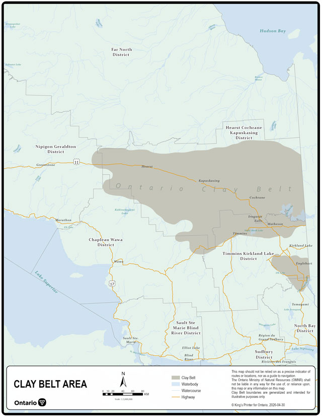
The ministry is taking steps to streamline Crown land disposition applications for agriculture in the Clay Belt area (map in Appendix B).
The Clay Belt is a vital region in Ontario, offering significant opportunities to grow the agri‑food sector while continuing to protect the land and natural resources that local communities depend on. To improve service delivery, the ministry has implemented a coordinated, single‑window avenue for inquiries.
For all application inquiries related to agricultural projects within the Clay Belt, email the ministry at mnr.clay.belt.agriculture@ontario.ca.
If you have specific application, local information or general requests, reach out to a local ministry work centre and speak with a staff member.
Appendix A — Disposition process
- Section 1 — Initial inquiry
The Ministry of Natural Resources discusses the proposal with the proponent to determine if there are factors which may limit or preclude the proposal from moving forward. The proposal may be modified based on this initial inquiry.- Section 2 — Scoping meeting
The Ministry of Natural Resources will invite the Ontario Ministry of Agriculture, Food and Agribusiness and the proponent to a meeting to discuss the application and disposition process and to provide further guidance to the proponent about application requirements.- Sections 3 and 4 — Applicant prepares and submits application
Applicant must prepare and submit a formal application for Crown land to the ministry for consideration.- Section 5 — Application screening
The ministry screens the project proposal under its Class Environmental Assessment – Resources Stewardship and Facility Development to determine the appropriate category and level of assessment required (A, B or C) and informs the proponent. Based on the initial screening and Class Environmental Assessment — Resources Stewardship and Facility Development categorization, the proponent may be directed by the Ministry of Natural Resources and/or the Ontario Ministry of Agriculture, Food and Agribusiness to provide additional supporting rationale to inform the ministry review (for example, business plans, environmental farm plans and studies). - Section 5 — Consultation
In concurrence with ministry review, the applicant will consult with potentially affected stakeholders and Indigenous communities, consistent with the Class Environmental Assessment – Resources Stewardship and Facility Development and Constitution Act Section 35 requirements. The applicant will also ensure that the Ministry of Energy and Mines and the Sustainable Forestry Licence holders, if applicable, have been given the appropriate notices of the pending disposition.- Section 5 — Reviewing the application
The ministry reviews the application and results of consultations and technical studies undertaken in accordance with the Class Environmental Assessment for Resources Stewardship and Facility Development category screening to ensure all factors (for example, environmental, land use, socio-economic and Indigenous) have been addressed to the ministry’s satisfaction. The Ontario Ministry of Agriculture, Food and Agribusiness reviews the applicant’s farm business plan to ensure that the proposal is viable and sustainable.- Ministry decision
After having reviewed the complete application, results of consultation and studies, and received confirmation from the Ontario Ministry of Agriculture, Food and Agribusiness on the viability and sustainability of the proposal, the ministry will either approve or deny the disposition.- Approved
- Section 6 — Issuing the occupational authority
Upon approval, the ministry will provide instructions to complete a client-initiated appraisal and survey instructions (as required). Upon receipt of the annual rent and any applicable administrative fees, the appropriate occupational authority will be considered validated.
- Section 6 — Issuing the occupational authority
- Denied
- Section 6 — Denying occupational authority
The ministry will provide rationale for the decision.
- Section 6 — Denying occupational authority
- Approved
- Ministry decision
- Section 5 — Reviewing the application
- Section 5 — Application screening
- Sections 3 and 4 — Applicant prepares and submits application
- Section 2 — Scoping meeting