Communication tower and antenna fee rate schedule for public lands
Fee rates for communication tower and antenna sites on public lands, under the Public Lands Act policy PL 4.10.02 Communication tower and antenna sites on public lands.
Communication tower and antenna fee rates
| Year | Bush zone | Remote zone | Rural zone (sites up to 0.033 hectares) | Rural zone (sites over 0.033 hectares) | Population centre | Non- cellular rate | Non-revenue producing rate |
|---|---|---|---|---|---|---|---|
| 2021 | $6,259 | $8,944 | $8,944 | $10,732 | $13,558 | $2,798 | $1,281 |
| 2022 | $6,384 | $9,123 | $9,123 | $10,947 | $13,829 | $2,854 | $1,307 |
| 2023 | $6,512 | $9,305 | $9,305 | $11,166 | $14,106 | $2,911 | $1,333 |
| 2024 | $6,642 | $9,491 | $9,491 | $11,389 | $14,388 | $2,969 | $1,360 |
| 2025 | $6,775 | $9,681 | $9,681 | $11,617 | $14,676 | $3,028 | $1,387 |
| 2026 | $6,911 | $9,875 | $9,875 | $11,849 | $14,970 | $3,089 | $1,415 |
| 2027 | $7,049 | $10,073 | $10,073 | $12,086 | $15,269 | $3,151 | $1,443 |
| 2028 | $7,190 | $10,274 | $10,274 | $12,328 | $15,574 | $3,214 | $1,472 |
| 2029 | $7,334 | $10,479 | $10,479 | $12,575 | $15,885 | $3,278 | $1,501 |
| 2030 | $7,481 | $10,689 | $10,689 | $12,827 | $16,203 | $3,344 | $1,531 |
| 2031 | $7,631 | $10,903 | $10,903 | $13,084 | $16,527 | $3,411 | $1,562 |
| 2032 | $7,784 | $11,121 | $11,121 | $13,346 | $16,858 | $3,479 | $1,593 |
| 2033 | $7,940 | $11,343 | $11,343 | $13,613 | $17,195 | $3,549 | $1,625 |
| 2034 | $8,099 | $11,570 | $11,570 | $13,885 | $17,539 | $3,620 | $1,658 |
| 2035 | $8,261 | $11,801 | $11,801 | $14,163 | $17,890 | $3,692 | $1,691 |
| 2036 | $8,426 | $12,037 | $12,037 | $14,446 | $18,248 | $3,766 | $1,725 |
| 2037 | $8,595 | $12,278 | $12,278 | $14,735 | $18,613 | $3,841 | $1,760 |
| 2038 | $8,767 | $12,524 | $12,524 | $15,030 | $18,985 | $3,918 | $1,795 |
| 2039 | $8,942 | $12,774 | $12,774 | $15,331 | $19,365 | $3,996 | $1,831 |
| 2040 | $9,121 | $13,029 | $13,029 | $15,638 | $19,752 | $4,076 | $1,868 |
Rates in all zones and in all rate-categories are increased by 2% per year on a compounded basis. Amounts are to be rounded to the nearest dollar.
Refer to PL 4.10.02 Communication tower and antenna sites on public lands for more information on applicable fees, including co-location fees, non-cellular fees and fees for non-revenue producing tower and antenna sites and related definitions.
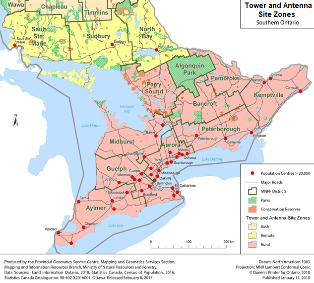
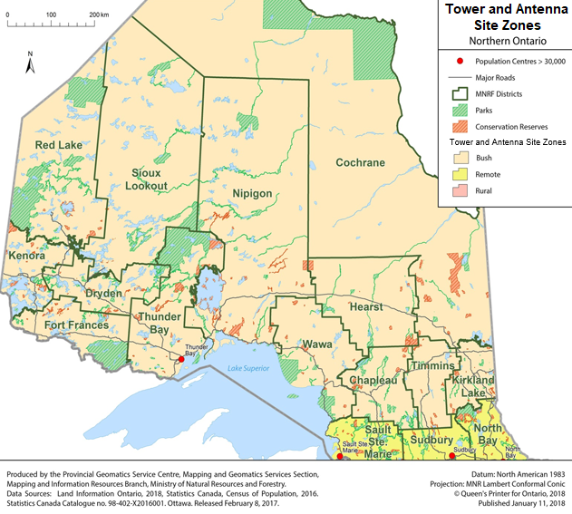
Zone definitions
Bush zone
Refers to the part of Northern Ontario situated within the ministry’s administrative districts in:
- Red Lake
- Kenora
- Fort Frances
- Dryden
- Sioux Lookout
- Thunder Bay
- Nipigon
- Cochrane
- Wawa
- Hearst
- Chapleau
- Timmins
- Kirkland Lake
A typical tower or antenna site would be 1.6 to 2 hectares in size, subject to final site plan and survey.
Remote zone
Refers to the part of Northern Ontario situated south of the Bush Zone and situated within the ministry’s North Bay, Sudbury and Sault Ste. Marie administrative districts. A typical tower or antenna site would be 1.6 to 2 hectares in size, subject to final site plan and survey.
Rural zone
Refers to the area of Central and Southern Ontario situated south of the Remote Zone and situated within the ministry’s administrative districts in:
- Kemptville
- Pembroke
- Bancroft
- Peterborough
- Parry Sound
- Midhurst
- Aurora
- Guelph
- Aylmer
A typical tower or antenna site would be either up to 0.033 hectares or over 0.033 hectares, typically 1.6 to 2 hectares in size, subject to final site plan and survey.
Population centres
Refers to all communities within Ontario with an urban or suburban population greater than 30,000. A typical tower or antenna site would be either 0.033 hectares or 1.6 to 2 hectares in size, subject to final site plan and survey.
Maps
Tower and antenna site zones map – Northern Ontario
Tower and antenna site zones map – Southern Ontario