R.R.O. 1990, Reg. 608: RESTRICTED USE OF LEFT LANES BY COMMERCIAL MOTOR VEHICLES, Under: Highway Traffic Act, R.S.O. 1990, c. H.8
Highway Traffic Act
R.R.O. 1990, REGULATION 608
RESTRICTED USE OF LEFT LANES BY COMMERCIAL MOTOR VEHICLES
Consolidation Period: From June 10, 2025 to the e-Laws currency date.
Last amendment: 113/25.
Legislative History: 442/93, 74/94, 105/97, 717/98, 432/99, 218/00, 523/00, 370/04, 619/05, 42/08, 384/08, 366/11, 408/11, 460/11, 285/12, 9/13, 299/13, 204/14, 216/14, 91/15, 183/15, 1/16, 201/16, 18/18, 26/19, 108/20, 661/20, 638/21, 524/22, 113/25.
This is the English version of a bilingual regulation.
1. (1) Subject to subsection (2), no person shall operate a commercial motor vehicle or any combination of a commercial motor vehicle and a towed vehicle that exceeds 6.5 metres in length in the left lane or, where the left lane has been designated as a high occupancy vehicle lane, in the lane adjacent to the high occupancy vehicle lane of those portions of a highway described in the Schedules. O. Reg. 113/25, s. 1.
(2) Subsection (1) does not apply to a person operating a commercial motor vehicle if,
(a) the vehicle is a bus, an ambulance or a fire apparatus;
(b) the vehicle is engaged in maintenance or construction;
(c) the vehicle is a tow truck that has been requested to provide towing services or roadside assistance services to a vehicle in or near the left lane, and operating the tow truck in the lane is necessary to access the location of the vehicle; or
(d) an emergency requires the use of the lane by the vehicle. O. Reg. 113/25, s. 1.
(3) In this section,
“towing services” and “roadside assistance services” have the same meanings as in the Towing and Storage Safety and Enforcement Act, 2021. O. Reg. 113/25, s. 1.
2. (1) A sign indicating that commercial motor vehicles are prohibited in a lane of a highway shall be in the form and dimensions prescribed and illustrated in the following Figure:
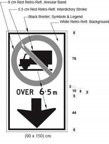
Text alternative: Illustration of an overhead sign containing an image at the top of a truck in a circle with an interdictory stroke “no” symbol. Below that appear the words “OVER 6.5 m” and a black arrow appears at the bottom of the sign pointing down. The sign has a white reflective background with the truck image, arrow and words appearing in black. The circular “no” symbol is in red. The following measurements are written below the sign: (90 x 150) cm. The sign is surrounded by measurements of its different elements. This text alternative is provided for convenience only and does not form part of the official law.
R.R.O. 1990, Reg. 608, s. 2 (1); O. Reg. 619/05, s. 2 (1); O. Reg. 91/15, s. 1 (1).
(1.1) Despite subsection (1), in an area designated under the French Language Services Act, a sign indicating that commercial motor vehicles are prohibited in a lane of a highway shall be in the form and dimensions prescribed and illustrated in the following Figure:
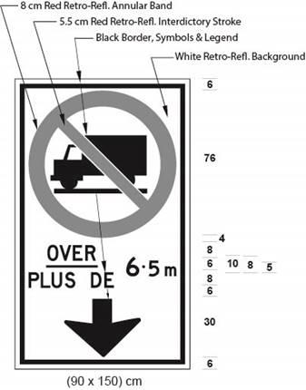
Text alternative: Illustration of an overhead sign containing an image at the top of a truck in a circle with an interdictory stroke “no” symbol. Below that appear the words “OVER/PLUS DE 6.5 m” and a black arrow appears at the bottom of the sign pointing down. The sign has a white reflective background with the truck image, arrow and words appearing in black. The circular “no” symbol is in red. The following measurements are written below the sign: (90 x 150) cm. The sign is surrounded by measurements of its different elements. This text alternative is provided for convenience only and does not form part of the official law.
O. Reg. 442/93, s. 1 (1); O. Reg. 619/05, s. 2 (2); O. Reg. 91/15, s. 1 (2).
(2) The sign referred to in subsection (1) or (1.1) shall be erected directly above the lane on those portions of a highway described in the Schedules. O. Reg. 442/93, s. 1 (2); O. Reg. 619/05, s. 2 (3); O. Reg. 201/16, s. 2.
3. (1) Where the conditions make it impracticable to place a sign in accordance with the requirements of section 2, a sign indicating that commercial motor vehicles are prohibited in a lane of a highway shall be in the form and dimensions illustrated in the following Figure:
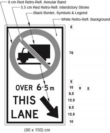
Text alternative: Illustration of a ground mounted sign containing an image at the top of a truck in a circle with an interdictory stroke “no” symbol. Below that appear the words “OVER 6.5 m”. At the bottom of the sign on the left side appear the words “THIS LANE” and on the right side appears a black arrow pointing down and diagonally to the right. The sign has a white reflective background with the truck image, arrow and words appearing in black. The circular “no” symbol is in red. The following measurements are written below the sign: (90 x 150) cm. The sign is surrounded by measurements of its different elements. This text alternative is provided for convenience only and does not form part of the official law.
R.R.O. 1990, Reg. 608, s. 3 (1); O. Reg. 619/05, s. 3 (1); O. Reg. 91/15, s. 2 (1).
(1.1) Despite subsection (1), in an area designated under the French Language Services Act, where the conditions make it impracticable to place a sign in accordance with the requirements of section 2, a sign indicating that commercial motor vehicles are prohibited in a lane of a highway shall be in the form and dimensions illustrated in the following Figure:
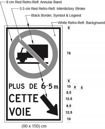
Text alternative: Illustration of a ground mounted sign containing an image at the top of a truck in a circle with an interdictory stroke “no” symbol. Below that appear the words “PLUS DE 6.5 m”. At the bottom of the sign on the left side appear the words “CETTE VOIE” and on the right side appears a black arrow pointing down and diagonally to the right. The sign has a white reflective background with the truck image, arrow and words appearing in black. The circular “no” symbol is in red. The following measurements are written below the sign: (90 x 150) cm. The sign is surrounded by measurements of its different elements. This text alternative is provided for convenience only and does not form part of the official law.
O. Reg. 442/93, s. 2; O. Reg. 619/05, s. 3 (2); O. Reg. 91/15, s. 2 (2).
(2) The sign referred to in subsection (1) shall be erected not less than 1.5 metres or more than 2.5 metres above the level of a highway described in the Schedules. R.R.O. 1990, Reg. 608, s. 3 (2); O. Reg. 201/16, s. 3 (1).
(3) The sign referred to in subsection (1.1) shall be erected not less than 1.5 metres or more than 2.5 metres above the level of a highway described in the Schedules and shall be erected in combination with the sign required by subsection (1), below it, to the right of it or up to 100 metres beyond it. O. Reg. 442/93, s. 2; O. Reg. 201/16, s. 3 (2).
1. That part of the King’s Highway known as No. 400 lying between a point situate at its intersection with the King’s Highway known as No. 401 in the City of Toronto and a point situate at its intersection with the King’s Highway known as No. 11 in the Township of Springwater.
O. Reg. 42/08, s. 1.
1. That part of the eastbound lanes of the King’s Highway known as No. 401 in the City of Kingston lying between a point situate 1300 metres measured easterly from its intersection with the centre line of the roadway known as Montreal Street and a point situate 750 metres measured westerly from its intersection with the centre line of the roadway known as Gardiner’s Road.
2. That part of the westbound lanes of the King’s Highway known as No. 401 in the City of Kingston lying between a point situate 1800 metres measured easterly from its intersection with the centre line of the roadway known as Montreal Street and a point situate 3200 metres measured westerly from its intersection with the centre line of the roadway known as Gardiner’s Road.
3. That part of the eastbound lanes of the King’s Highway known as No. 401 lying between a point situate 2440 metres measured westerly from its intersection with the centre line of the roadway known as Dixie Road in the City of Mississauga and a point situate 1400 metres. measured easterly from its intersection with the centre line of the roadway known as Nagle Road in the County of Northumberland.
4. That part of the westbound lanes of the King’s Highway known as No. 401 lying between a point situate 2000 metres measured easterly from its intersection with the centre line of the roadway known as Nagle Road in the County of Northumberland and a point situate 1970 metres measured westerly from its intersection with the centre line of the roadway known as Dixie Road in the City of Mississauga.
5. That part of the eastbound lanes of the King’s Highway known as No. 401 lying in the collector lanes between a point situate 1,860 metres measured westerly from its intersection with the centre line of the roadway known as Mississauga Road in the City of Mississauga and a point situate 2440 metres measured westerly from its intersection with the centre line of the roadway known as Dixie Road in the City of Mississauga.
6. That part of the westbound lanes of the King’s Highway known as No. 401 lying in the collector lanes between a point situate 1970 metres measured westerly from its intersection with the centre line of the roadway known as Dixie Road in the City of Mississauga and a point situate 900 metres measured easterly from its intersection with the centre line of the roadway known as Winston Churchill Boulevard in the City of Mississauga.
7. That part of the eastbound lanes of the King’s Highway known as No. 401 lying between a point situate 2,820 metres measured westerly from its intersection with the centre line of the roadway known as Winston Churchill Boulevard in the City of Mississauga and a point situate 1,860 metres measured westerly from its intersection with the centre line of the roadway known as Mississauga Road in the City of Mississauga.
8. That part of the westbound lanes of the King’s Highway known as No. 401 lying between a point situate 25 metres measured easterly from its intersection with the centre line of the roadway known as Winston Churchill Boulevard in the City of Mississauga and a point situate 2,555 metres measured westerly from its intersection with the centre line of the roadway known as Winston Churchill Boulevard in the City of Mississauga.
9. That part of the eastbound lanes of the King’s Highway known as No. 401 lying in the collector lanes between a point situate 1,310 metres measured easterly from its intersection with the centre line of the roadway known as James Snow Parkway in the Town of Milton and a point situate 2,820 metres measured westerly from its intersection with the centre line of the roadway known as Winston Churchill Boulevard in the City of Mississauga.
10. That part of the westbound lanes of the King’s Highway known as No. 401 lying in the collector lanes between a point situate 990 metres measured easterly from its intersection with the centre line of the roadway known as Trafalgar Road in the Town of Milton and a point situate 720 metres measured easterly from its intersection with the centre line of the roadway known as James Snow Parkway in the Town of Milton.
11. That part of the eastbound lanes of the King’s Highway known as No. 401 lying between a point situate at its intersection with the King’s Highway known as No. 8 in the City of Cambridge and a point situate 990 metres measured easterly at its intersection with the centre line of the roadway known James Snow Parkway in the Town of Milton.
12. That part of the westbound lanes of the King’s Highway known as No. 401 lying between a point situate 216 metres measured easterly from its intersection with the centre line of the roadway known as James Snow Parkway in the Town of Milton and a point situate at its intersection with the King’s Highway known as No. 8 in the City of Cambridge.
13. That part of the King’s Highway known as No. 401 lying between a point situate at its intersection with the King’s Highway known as No. 8 in the City of Cambridge and a point situate 1740 metres measured westerly from its intersection with the centre line of the roadway known as Wellington Road in the City of London.
14. That part of the King’s Highway known as No. 401 lying between a point situate 603 metres measured easterly from its intersection with the centre line of the roadway known as Essex County Road 42 in the Town of Lakeshore and a point situate 97 metres measured westerly from its intersection with the centre line of the King’s Highway known as No. 7902 (also known as Ojibway Parkway) in the City of Windsor.
O. Reg. 524/22, s. 1.
1. That part of the westbound lanes of the King’s Highway known as No. 403 in the City of Mississauga lying between a point situate at its intersection with the roadway known as Cawthra Road and a point situate at its intersection with the roadway known as Glen Erin Drive.
2. That part of the eastbound lanes of the King’s Highway known as No. 403 in the City of Mississauga lying between a point situate 910 metres measured westerly from its intersection with the centre line of the roadway known as Winston Churchill Boulevard and a point situate at its intersection with the roadway known as Eglinton Avenue East.
3. That part of the westbound lanes of the King’s Highway known as No. 403 lying between a point situate at its intersection with the roadway known as King Road in the City of Burlington and a point situate at its intersection with the roadway known as Golf Links in the City of Hamilton.
O. Reg. 42/08, s. 1.
1. That part of the King’s Highway known as No. 404 lying between a point situate at its intersection with the roadway known as Van Horne Avenue in the City of Toronto and a point situate 1400 metres measured southerly from its intersection with the centre line of the roadway known as Aurora Road in the Town of Aurora.
O. Reg. 42/08, s. 1.
1. That part of the private toll highway known as Highway 407 lying between a point situate at its intersection with the King’s Highway known as the Queen Elizabeth Way in the City of Burlington and a point situate at the centre line of the underpass structure of the roadway known as Brock Road in the City of Pickering.
O. Reg. 26/19, s. 1.
1. That part of the King’s Highway known as Highway 407 East lying between a point situate at the centre line of the underpass structure of the roadway known as Brock Road in the City of Pickering and a point situate 750 metres measured easterly from its intersection with the centre line of the roadway known as Lake Ridge Road in the Town of Whitby.
O. Reg. 201/16, s. 4; O. Reg. 26/19, s. 2.
1. That part of the King’s Highway known as No. 409 in the City of Toronto lying between a point situate at its intersection with the King’s Highway known as No. 401 and a point situate at its intersection with the roadway known as Carlingview Drive.
O. Reg. 42/08, s. 1.
1. That part of the northbound lanes of the King’s Highway known as No. 410 lying between a point situate 520 metres measured northerly from its intersection with the centre line of the roadway known as Courtneypark Drive East in the City of Mississauga in The Regional Municipality of Peel and a point situate at its intersection with the roadway known as Bovaird Drive East in the City of Brampton in The Regional Municipality of Peel.
2. That part of the southbound lanes of the King’s Highway known as No. 410 lying between a point situate 720 metres measured southerly from its intersection with the centre line of the roadway known as Bovaird Drive East in the City of Brampton in The Regional Municipality of Peel and a point situate at its intersection with the roadway known as Courtneypark Drive East in the City of Mississauga in The Regional Municipality of Peel.
O. Reg. 108/20, s. 1.
1. That part of the westbound lanes of the King’s Highway known as No. 417 in the City of Ottawa lying between a point situate at its intersection with the roadway known as St. Laurent Boulevard and a point situate 850 metres measured easterly from its intersection with the centre line of the roadway known as Richmond Road.
2. That part of the westbound lanes of the King’s Highway known as No. 417 in the City of Ottawa lying between a point situate 370 metres measured westerly from its intersection with the centre line of the roadway known as Richmond Road and a point situate 265 metres measured easterly from its intersection with the centre line of the roadway known as Moodie Drive.
3. That part of the westbound lanes of the King’s Highway known as No. 417 in the City of Ottawa lying between a point situate 1105 metres measured westerly from its intersection with the centre line of the roadway known as Moodie Drive and point situate 965 metres measured easterly from its intersection with the centre line of the roadway known as Palladium Drive.
4. That part of the westbound lanes of the King’s Highway known as No. 417 in the City of Ottawa lying between a point situate 465 metres measured easterly from its intersection with the centre line of the roadway known as Palladium Drive and a point situate 975 metres measured westerly from its intersection with the centre line of the roadway known as Carp Road.
5. That part of the eastbound lanes of the King’s Highway known as No. 417 in the City of Ottawa lying between a point situate 500 metres measured westerly from its intersection with the centre line of the roadway known as Carp Road and a point situate at its intersection with the roadway known as St. Laurent Boulevard.
O. Reg. 42/08, s. 1; O. Reg. 366/11, s. 1; O. Reg. 285/12, s. 1; O. Reg. 204/14, s. 1.
1. That part of the southbound lanes of the King’s Highway known as No. 427 lying between a point situate at its intersection with the roadway known as Rutherford Road in the City of Vaughan in The Regional Municipality of York and a point situate at its intersection with the roadway known as Airport Road where Airport Road continues as Dixon Road in the City of Toronto.
2. That part of the northbound lanes of the King’s Highway known as No. 427 lying between a point situate at its intersection with the roadway known as Renforth Drive in the City of Toronto and a point 600 metres measured southerly from its intersection with the centre line of the roadway known as Rutherford Road in the City of Vaughan in The Regional Municipality of York.
3. That part of the King’s Highway known as No. 427 in the City of Toronto lying between a point situate at its intersection with the roadway known as Rathburn Road and a point situate at its intersection with the roadway known as Dundas Street West.
O. Reg. 42/08, s. 1; O. Reg. 638/21, s. 1.
SCHEDULE 10
QUEEN ELIZABETH WAY
1. That part of the eastbound lanes of the King’s Highway known as the Queen Elizabeth Way lying between a point situate 1500 metres measured westerly from its intersection with the centre line of the roadway known as Ford Drive in the Town of Oakville and a point situate 25 metres measured westerly from its intersection with the centre line of the roadway known as The East Mall in the City of Toronto.
2. That part of the westbound lanes of the King’s Highway known as the Queen Elizabeth Way lying between a point situate 25 metres measured westerly from its intersection with the centre line of the roadway known as The East Mall in the City of Toronto and a point situate 500 metres measured westerly from its intersection with the centre line of the roadway known as Ford Drive in the Town of Oakville.
3. That part of the eastbound lanes of the King’s Highway known as the Queen Elizabeth Way lying between a point situate 500 metres measured northerly from its intersection with the roadway known as North Shore Boulevard in the City of Burlington and a point situate 800 metres measured westerly from its intersection with the roadway known as Glendale Avenue in the Town of Niagara-on-the-Lake.
4. That part of the westbound lanes of the King’s Highway known as the Queen Elizabeth Way lying between a point situate at its intersection with the centre line of the roadway known as Mountain Road in the City of Niagara Falls and a point situate 500 metres measured northerly from its intersection with the roadway known as North Shore Boulevard in the City of Burlington.
5. That part of the eastbound lanes of the King’s Highway known as the Queen Elizabeth Way lying between a point situate 1120 metres measured easterly from its intersection with the roadway known as Glendale Avenue in the Town of Niagara-on-the-Lake and a point situate at its intersection with the centre line of the roadway known as Mountain Road in the City of Niagara Falls.
O. Reg. 42/08, s. 1; O. Reg. 408/11, s. 1.
SCHEDULE 11
QUEEN ELIZABETH WAY AND HIGHWAY NO. 403
1. That part of the eastbound lanes of the King’s Highway known as the Queen Elizabeth Way and No. 403 lying between a point situate 785 metres measured westerly from its intersection with the centre line of the roadway known as Guelph Line in the City of Burlington and a point situate 1500 metres measured westerly from its intersection with the centre line of the roadway known as Ford Drive in the Town of Oakville.
2. That part of the westbound lanes of the King’s Highway known as the Queen Elizabeth Way and No. 403 lying between a point situate 500 metres measured westerly from its intersection with the centre line of the roadway known as Ford Drive in the Town of Oakville and a point situate 15 metres measured easterly from its intersection with the centre line of the roadway known as Walkers Line in the City of Burlington.
O. Reg. 42/08, s. 1; O. Reg. 460/11, s. 1.
1. That part of the eastbound lanes of the King’s Highway known as No. 7 in the City of Kitchener in The Regional Municipality of Waterloo lying between a point situate 230 metres measured westerly from its intersection with the centre line of the roadway known as King Street East and a point situate at its intersection with the centre line of the roadway known as Wedgewood Drive.
2. That part of the westbound lanes of the King’s Highway known as No. 7 in the City of Kitchener in The Regional Municipality of Waterloo lying between a point situate 45 metres measured westerly from its intersection with the centre line of the roadway known as King Street East and a point situate at its intersection with the centre line of the roadway known as Wedgewood Drive.
O. Reg. 18/18, s. 2.
1. That part of the eastbound lanes of the King’s Highway known as No. 8 in the City of Kitchener in The Regional Municipality of Waterloo lying between a point situate 110 metres measured easterly from its intersection with the centre line of the roadway known as Franklin Street North and a point situate 70 metres measured westerly from its intersection with the centre line of the roadway known as Sportsworld Drive.
2. That part of the westbound lanes of the King’s Highway known as No. 8 in the City of Kitchener in The Regional Municipality of Waterloo lying between a point situate 275 metres measured westerly from its intersection with the centre line of the roadway known as Fairway Road South and a point situate 330 metres measured westerly from its intersection with the centre line of the roadway known as King Street East.
O. Reg. 18/18, s. 2.
1. That part of the eastbound lanes of the King’s Highway known as No. 7/8 in the City of Kitchener in The Regional Municipality of Waterloo lying between a point situate 230 metres measured westerly from its intersection with the centre line of the roadway known as King Street East and a point situate 170 metres measured easterly from its intersection with the centre line of the roadway known as Fischer-Hallman Road.
2. That part of the westbound lanes of the King’s Highway known as No. 7/8 in the City of Kitchener in The Regional Municipality of Waterloo lying between a point situate 45 metres measured westerly from its intersection with the centre line of the roadway known as King Street East and a point situate 170 metres measured easterly from its intersection with the centre line of the roadway known as Fischer-Hallman Road.
O. Reg. 18/18, s. 2.