Environmental Planning
Environmental planning (2.0)
2.1 Introduction
As the field of environmental planning has evolved, a variety of documents have been produced to assist practitioners. These documents include the trilogy of Watershed Planning documents (MOEE, MNR, 1993), as well as others (Science and Technology Task Group, 1995; CVC, 1996). Collectively, these documents provide:
- A rationale for considering watersheds as the natural and logical boundary for environmental and land use planning;
- Direction with respect to the types of environmental studies that are required and the necessary expertise; and
- A process designed to assist agencies and practitioners in working together to balance social, environmental and economic needs, using an ecosystem approach.
The objective of this chapter will be to draw upon the above noted documents together with other publications (including approximately 100 subwatershed plans that have been completed within Ontario) in order to:
- Describe the environmental planning process and its relationship with the municipal land use process;
- Discuss, in general terms, the process used and the typical deliverables from each type of environmental study;
- Provide direction as to how the deliverables from existing studies may be used to assist and simplify the SWMP design process; and
- Provide direction as to how stormwater management may be integrated with the environmental and municipal land use planning processes.
2.2 Environmental and municipal land use planning
2.2.1 General
Within each municipality, there will be differences as to how municipal land use and environmental planning will be undertaken. It is, therefore, not possible to define a process that is applicable to all municipalities for all types of studies. The intent of this section, therefore, will be to describe environmental and municipal land use planning in general.
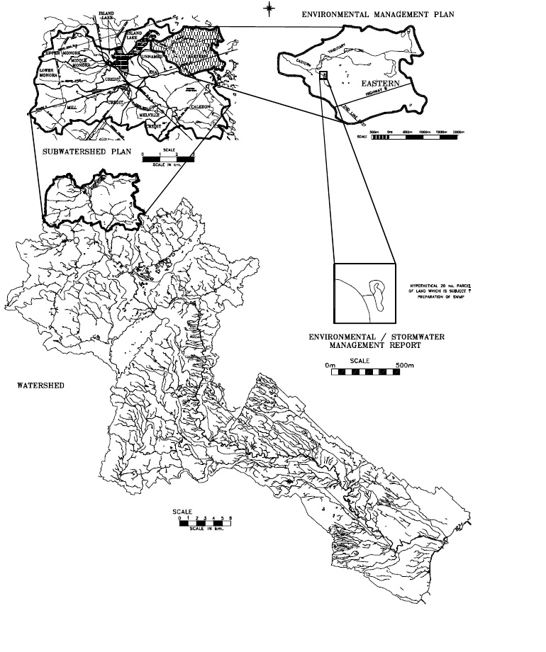
Figure 2.1 illustrates general inter-relationships between municipal land use and environmental planning. The agencies that are typically involved with the review of documents at each phase are listed. Also provided (Figure 2.2) is a graphical representation of each of the four types of environmental studies. This graphic provides an overview of the scale of each study and, therefore, the degree of detail (or type of product) to be produced.
Provided below is a brief description of each of the environmental planning studies (i.e., Watershed Plan, Subwatershed Plan, Environmental Management Plan and Environmental/ Stormwater Management Plan) that may be undertaken. The objective of this section is to indicate what each type of plan typically provides. Several agencies have produced procedural manuals for environmental planning studies.
There may be other terms used for each type of plan in different jurisdictions. It is important to note the level of detail for each type of plan. In some cases the plans or elements of the plans may be combined.
2.2.2 Managing for uncertainty
Implicit in the watershed and subwatershed planning process is the uncertainty associated with deriving environmental form, functions and linkages, and forecasting future impacts based on land use and land management changes. The concept of adaptive environmental management recognizes this uncertainty, acknowledges learning through experimentation, and promotes using the knowledge gained to direct changes in management activities.
In order to measure the success of a watershed and subwatershed plan, it is imperative that clearly defined goals and objectives be formulated, and that a monitoring plan be implemented that provides the information necessary to evaluate whether the goals and objectives are being met. Changes to the recommended plan may be necessary if the results of the monitoring show that the objectives are not being achieved. As the process moves from the watershed, subwatershed and environmental management plans to the stormwater management report, management decisions can be adapted to better fit the local circumstances of each subwatershed, tributary and plan of subdivision. This approach allows for flexibility, consensus building and joint learning by managers of the environment, proponents for change and the public.
2.2.3 Required expertise
Undertaking environmental planning studies in concert with municipal land use studies will reduce the amount of work to be undertaken and streamline the review process, provided the proper expertise and representation from the agencies, public and consultants is available at the appropriate time (Figure 2.1).
Figure 2.1: General Relationship Between the Environmental Planning and the Municipal Land Use Planning Process
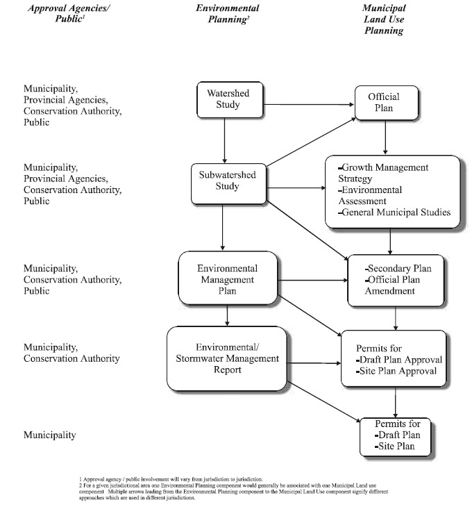
Most stakeholders are involved at the initial stages where key decisions on broad issues (e.g., establishing goals/objectives, incorporating public input, establishing an implementation process) are required. Once consensus has been achieved for issues at the subwatershed or watershed scale, fewer agencies are generally required to review subsequent documents (e.g., EMPs, Environmental/SWM Plans).
As the process has evolved, so too have the disciplines required to undertake and review the studies. The expertise required for each study is dependent upon the level of detail required. However, in general, both the proponent and review agency require expertise in:
- surface water resources;
- groundwater;
- aquatic resources;
- water quality;
- terrestrial ecology;
- municipal engineering;
- fluvial geomorphology; and
- environmental and land use planning.
2.2.4 Watershed plan
As is illustrated in Figure 2.2, watershed plans deal with the area drained by a major river (e.g., Credit, Grand, Rideau, Don, Thames) and its tributaries. The study area defined by the natural drainage boundaries of the watershed is considerable and usually at least 1,000 km².
A watershed plan is generally of value for addressing environmental issues associated with studies on the scale of an Official Plan. The study may be used to provide an overall picture as to how land use practices have influenced environmental resources or how land use changes should take place without causing adverse impacts to the watershed resources. Along with the strategic direction, the document may contain recommendations on implementation and funding, as well as resource management goals and objectives.
The watershed plan also provides direction for subsequent subwatershed studies. In this regard, information pertaining to resources, constraints, sources of contamination, key issues, resource goals and environmental targets may be provided.
2.2.5 Subwatershed plan
The area under consideration in a subwatershed plan is typically 50 to 200 km². In some jurisdictions it is the first document produced. It is at this stage that all relevant agencies and the public participate. With a broad range of input being received and with the proper technical and implementation steps being undertaken, it should be possible to carry out subsequent studies at a much smaller scale (typically at a tributary or Secondary Plan level). The key steps of a subwatershed plan are shown in Figure 2.3, and are briefly described below.
Figure 2.2: Graphical Representation of Environmental Studies:
Collect background information
The initial step involves the collection of background information. This may include relevant reports and base maps, as well as historical information that may be of value for defining change within the subwatershed over time. The relationship of the subwatershed study to a watershed plan, or other urban drainage, land use and planning studies should also be defined.
Establish existing environmental conditions
A series of technical studies will be undertaken to establish existing environmental conditions. In some cases, the information will be available from previous studies, while in others some field work will be required. Typical component studies that need to be undertaken include:
- Surface water resources, including an evaluation of the water budget, baseflows, and peak flows as well as flood line assessment;
- Hydrogeology, including definition of geologic conditions; groundwater flow patterns and recharge/discharge areas; location, capacity, and quality of aquifers; and quantification of existing well usage;
- Surface water quality, including characterization of water quality constituents for dry and wet weather conditions;
- Fluvial geomorphology, including classification of streams with respect to their stability and sensitivity to land use change;
- Terrestrial resources, including characterization of resources such as wetlands, woodlots, landforms and specially designated natural areas; and
- Aquatic resources, including fish and macroinvertebrate (aquatic insect) inventories.
These component studies will identify the location, areal extent, present status, significance and sensitivity of the existing natural environment within the subwatershed.
Identify form, function and linkage of natural systems
The inter-relationships between the different resources need to be defined. This is done, in part, via an overlay process using GIS and by assessing the technical information collected in the previous step. The inter-relationships (e.g., the presence of a high quality fishery in catchment areas containing good riparian cover, high recharge and wetlands) are important in order to identify key attributes which need to be protected or restored.
Establish environmental goals and objectives
An understanding of the existing conditions and linkages will assist stakeholders in defining environmental goals and objectives for the subwatershed. These goals and objectives will be used as a basis for developing alternate subwatershed management strategies, and will also likely be used in subsequent, more detailed studies.
Figure 2.3: Components of a Subwatershed Plan:
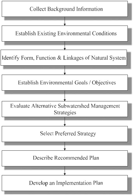
Develop and evaluate alternative subwatershed management strategies
Alternative management strategies will be developed for the subwatershed which involve various combinations of management options, including SWMPs. When implemented collectively, the management options contained in each alternative are sufficient to meet the defined environmental goals and objectives for the subwatershed.
Select preferred strategy
A preferred strategy is selected from the alternatives based on criteria which may include:
- public acceptance;
- cost;
- technical feasibility;
- ability to meet defined goals and objectives;
- potential of the strategy to enhance the environment; and
- impact of the strategy on future land uses.
Describe recommended plan
The Recommended Plan for the Preferred Strategy will specify areas for protection, restoration and/or enhancement. It will also identify areas which are developable, or developable subject to further study. Typically, the Recommended Plan will also provide a general description of each SWMP type, together with items relating to technical considerations, social, economic and environmental benefit, environmental criteria, land requirements/impact and approximate cost.
Implementation plan
This part of the study will provide direction with respect to the steps which are necessary to implement the recommended plan. Components of the implementation plan include:
- subwatershed plan administration;
- rehabilitation/restoration opportunities; and
- implementation considerations for each SWMP, including:
- land use planning considerations;
- cost;
- review agency;
- funding;
- education/stewardship opportunities;
- monitoring requirements;
- future studies/initiatives;
- timeframe for review/update of plan; and
- community participation.
As was stated previously, one of the objectives of a Subwatershed Plan is to provide information that may be used in subsequent, more detailed studies. One product that has been produced in several subwatershed studies is a Fact Sheet. Table 2.1 shows a fact sheet for a tributary within the subwatershed. Fact Sheets are often used to summarize key resources and targets, and may be used as a basis to establish the appropriate studies and measures to be undertaken, typically at the Official Plan Amendment or Secondary Plan stage.
2.2.6 Environmental management plan
The Environmental Management Plan (also referred to as an Environmental Impact Report, Environmental Area Plan or Master Environmental Servicing Plan) is typically carried out prior to consideration of Draft Plan Approval. The relationship of the EMP to other studies is shown in Figures 2.1 and 2.2.
Whereas watershed and subwatershed plans have been ongoing since the late 1980's, EMPs are a relatively new study. The deliverables from an EMP, therefore, are not as consistent from jurisdiction to jurisdiction. The typical area under consideration for an EMP is 2 to 10 km². The boundaries for the EMP may match the tributary subcatchment boundary or Secondary Plan boundary or a portion thereof.
With respect to the level of detail of the EMP, one of the objectives of the Subwatershed Plan was to provide sufficient detail so that future work would not be required beyond the tributary or Secondary Plan level. In an analogous manner, the EMP should be of sufficient detail that individual subdivision plans may proceed pending the completion of the EMP. Provided below is an overview of the components to be undertaken in an EMP.
Review existing information
All existing background information should be reviewed to confirm the level of detail and suitability for use in the EMP. Information will be available from the subwatershed study, as well as other studies completed within the study area. Relevant information may include:
- field inventories of woodlots, wetland communities and other vegetation communities;
- land uses for both existing and proposed conditions;
- historical data relating to surface or groundwater quality;
- information relating to aquatic habitat; and
- existing hydrologic modelling and/or floodplain mapping.
Table 2.1: Credit river subwatershed No. 19 – Eastern Tributary Fact Sheet
Environmental resources
Groundwater Resources:
- Significant baseflow contribuition in the upper reach
- Moderate to high susceptibility to contamination
Surface Water Resources:
- 83.0 ha drainage area
- Intermittent baseflow, limited to upper reaches
- No floodplain mapping completed, no known flood prone areas
- Small online ponds, not used for stormwater management
Aquatic Resources:
- Level 2 riparian corridor
- Level 3 riparian corridor
- 50-70% of riparian corridor in natural vegetation
- Moderately tolerant to very tolerant warm water aquatic community
Terrestrail Resources:
- 15 features in high recharge or on riparian corridors (11 < 4 ha, 2 @ 4-16 ha, 2 @ 36-100 ha)
- 1 secondary terrestrial corridor for protection/revegetation
- 5 other features (4 < 4 ha, 1 @ 4-16 ha)
- Linkage to Orangeville Reservoir ESA No.58
Stream Morphology:
- Stable natural channel systems with isolated impacts from rural land use practices (cattle crossings)
Existing Land Uses:
- Primarily low intensity agricultural uses
Environmental protection targets
Groundwater:
- Protect groundwater discharge areas
- Maintain existing stream discharge areas; minium 5% average annul daily flow
- Maintain or enchance on-site recharge and discharge volumes
- Maintain current groundwater quality
Surface water quantity and quality:
- Peak flows requirements to be determined
- Maintain baseflow volumn
- Maximum temperature 30°C
- Total Phosphorus ≤ 0.1 mg/L (annual average for dry/wet weather conditions)
- Suspended Solids ≤ 20/200 mg/L (annual average for dry/wet weather conditions)
- Dissolved Oxygen 4.0 mg/L minimum at all times
- E. coli 100/1,000 cts/100 ml (geometric mean conditions for dry/wet weather conditions)
Aquatic Communities:
- Class 3 tolerant warmwater aquatic communities
- Class 3 moderate tolerant aquatic community
- Level 2 riparian and valley corridor
- At least 5% of stream reaches pool-riffle dominated
- Minimum pool depths: 0.2 m
- 30-50% of banks with woody riparian vegetation
Terrestrial Communities:
- maintain water levels and surface area of marsh features
- protect all Class 1 features
- use native species for revegetating corridors
- select vegetation community types based on soil moisture/fertility, flooding/water table regime and composition of adjacent communities (also see Tables 7.4.2 to 7.4.4)
Stream Morphology:
- maintain post-development shear stress conditions on channel systems to pre-development conditions by controlling bankfull frequencies and durations
- maintain dynamically stable, natural channel systems
- balance sediment regime
- minimize fine sediment loads from runoff
Key best management practices (refer to section 5.0 of the main report for details)
- stormwater runoff volume controls utilizing large open space areas and centralized end-of-pipe facilities to infiltrate clean runoff for maintaining water budget and stream bankfull flow conditions.
- stormwater runoff flow controls and detention ponds for flood control, water quality control and stream morphology protection
- development exclusion in all Class 1 features
- minimize the potential for contaminant spills and minimize applications of de-icing agents, fertilizers, pesticides, etc..
- stream restoration for reaches impacted by livestock access, see Section 7
Future study requirements
General:
- Environmental Management Planning Studies on a tributary basis (may include studies listed below)
- headwater tributary assessments
Groundwater Resources:
- detailed hydrologic studies on baseflow and water supply impacts resulting from future urban growth and urbanization and for the implementation of stormwater management facilities
- investigate area for potential groundwater development
Surface Water Resources:
- Hydrologic and hydraulic studies for land use changes
- prepare floodplain mapping
Surface Water Resources:
- Hydrologic and hydraulic studies for land use changes
- prepare floodplain mapping
Aquatic Resources:
- identify riparian and valley corridor width based on functional characteristics and existing vegetation features
Terrestrial Resources:
- EIS required adjacent to all Class 1 features
- EIS required within/adjacent to all Class 2 features
- Naturalization plans for all Class ½ riparian/valley corridors and terrestrial regeneration areas
Stream Morphology:
- detailed fluvial geomorphology study to determine design criteria for managing bankfull flow conditions and for natural channel design works, as required
Source: Aquafor Beech Ltd., Environmental Planning for the Credit River Headwaters Subwatershed No. 19, prepared for CVC, 1997.
Define existing environmental conditions and establish constraint/opportunity mapping
Existing information should be utilized and further study should be focussed on filling gaps and enhancing the understanding of key resources. Detailed constraint and opportunity mapping will be prepared which describes the environmental resources, together with the associated land requirements.
The smaller scale analysis done for an EMP allows knowledge to be refined and more specific deliverables (Table 2.2) to be provided, as compared to a Subwatershed Study.
Establish preferred environmental and stormwater management strategy
Typically, impact assessments are carried out (i.e., how does the hydrologic cycle change, how will increases in metals loadings impact fisheries) for the proposed land use. Alternative management strategies are developed, each including a series of environmental and stormwater management practices. Collectively, the management practices will ensure that the environmental resources are protected, restored or enhanced in accordance with defined goals and objectives. Comparative evaluation of the strategies will lead to the selection of the preferred alternative.
Preparation of the environmental management plan
An Environmental Management Plan which summarizes the findings of the previous steps should be prepared. It is important to ensure that the plan highlights the deliverables and is of sufficient detail such that all remaining environmental and/or stormwater management work may be completed as conditions of the Draft or Site Plan stage. Key deliverables may include:
- a map illustrating areas to be protected/restored, together with proposed development patterns;
- preliminary design of restoration/enhancement measures, e.g., proposed cross-section of terrestrial/aquatic/recreation corridor;
- summary of findings from the EIS;
- location sizing and preliminary design of all SWMPs, together with drainage areas;
- identification of areas where special consideration is required at the subdivision plan stage, e.g., areas requiring grading limits and tree preservation planning;
- detailed description of steps to be undertaken at the subdivision plan phase;
- preliminary sediment control plan; and
- operation and maintenance considerations.
Other deliverables that may be presented, depending upon the level of detail and preference/requirements of the agencies include:
- land use patterns;
- open space connections and linkages;
- top of bank delineation; and
- major/minor system routes.
Table 2.2: detailed component studies of an environmental management plan
Surface Water and Groundwater:
- identification of flow characteristics for all watercourses
- preparation of a water budget
- preparation of floodplain mapping
- description of groundwater resources, including identification of recharge/discharge areas
- description of water quality
- description of the relationship between ground and surface water and dependencies between these features and the surrounding terrestrial and aquatic resources
Aquatic Resources/Stream Morphology:
- definition of the morphology of each stream, including the general condition and assessment of erosion sites
- characterization of the aquatic resources within each watercourse
- determination of headwater streams that provide a function and, therefore, need to be protected
- determination of stream corridor boundaries necessary to protect/enhance the functions provided
- description of the relationship and dependencies between these features and the surrounding surface water, groundwater and terrestrial resources
Terrestrial Resources:
- characterization of ecologic resources including woodlots, wetlands and other vegetative features
- determination, through existing information or the completion of an EIS, of vegetative features which are to be retained and/or enhanced together with appropriate setbacks, appropriate adjacent land uses, as well as definition of features which may be replaced or are not required to be protected
- description of the relationship and dependencies between these features and the surrounding surface water, groundwater and aquatic resources
2.2.7 Environmental/stormwater management report
The Environmental/Stormwater Management Report is generally prepared in order to meet conditions set at the Draft Plan or Site Plan stage. The plan provides details with respect to the proposed environmental and stormwater management measures, and is usually submitted with grading and erosion plans and site servicing plans.
Several documents detail the requirements of these reports. The specific requirements will vary from municipality to municipality. The components of the study will also vary depending upon whether an EMP and/or subwatershed study has been completed.
Typical deliverables from an Environmental/Stormwater Management Report include:
- detailed design of SWMPs, including connections and outfalls;
- detailed design of environmental restoration works (e.g., stream protection works);
- delineation/confirmation of constraint boundaries (e.g., significant woodland, top-of-bank, geotechnical hazard area);
- sediment/erosion control plans;
- detailed reports relating to geotechnical and water resources;
- major/minor systems;
- delineation of grading limits and tree preservation planning;
- revegetation/landscape plans;
- access routes, disposal areas for operation/maintenance; and
- landscape features including trails, benches and other recreational and interpretive amenities.
2.2.8 Review Process
Figure 2.1 shows the stakeholders who are involved at each phase of the review process. The review process, as shown, involves a majority of the stakeholders at the initial stages where key decisions involving a number of issues (e.g., establishing goals/objectives, incorporating public input, establishing an implementation process) are required. Once consensus has been achieved for a majority of issues at the subwatershed or watershed scale, then fewer agencies are generally required to review subsequent documents (e.g., EMPs, Environmental/SWM Plans).
2.3 Integrated planning for sormwater management
Good planning which has regard for the need for stormwater management at the outset, combined with a recognition of the ecological attributes and functions of the watershed, provides the fundamental basis for achieving stormwater quality and quantity improvement efficiently and cost effectively. At this scale, stormwater management opportunities afforded by the physiographic and ecological features of the watershed can be identified, and capitalized upon. Areas where soils are permeable and suited to infiltration, existing vegetation communities which can function as biofilters and landforms that are naturally conducive to the implementation of detention initiatives will all be identified along with a suite of other characteristics which may be preserved or modified to achieve stormwater management objectives. The watershed planning approach, which is now ingrained within the municipal planning process, ensures that the important features and other interrelated factors are identified and understood at a regional scale. As a result, stormwater management opportunities afforded by the existing natural heritage features and functional systems are identified early in the process. This helps ensure that these opportunities will not be overlooked or lost when stormwater management initiatives are implemented at a site-specific scale.
2.3.1 Watershed scale solutions
At the watershed scale, the framework for the generation of a stormwater management system, which is integrated with the environment, is established. Effective stormwater management solutions to be explored at a watershed scale are rooted in a recognition of the value and potential function of the existing physical and ecological characteristics of the region. The following examples are provided:
- Identification of areas of high soil permeability presents opportunities to incorporate infiltration-based SWMPs which can provide groundwater recharge (provided that the quality of the stormwater is adequate);
- Existing vegetation affords opportunities to intercept rainfall and moderate rates of discharge;
- Areas of rich organic soils afford the opportunity to enhance water quality through biofiltration;
- Natural depressions in landform provide opportunities to implement detention type SWMPs while minimizing the requirement for extensive earthworks, and the associated costs; and
- The configuration of stream corridors, vegetation units and other terrestrial features may present opportunities to locate SWMPs to improve linkages between existing features, enhancing the connectivity of terrestrial habitats and affording benefits that extend beyond the limits of the watercourse.
Watershed planning is the most effective means of ensuring that responsible stormwater management solutions that are fully integrated with the regional ecosystem are achieved. It is also important to consistently apply this ecosystem-based approach at the community and site-specific levels to ensure that stormwater management opportunities afforded by site and context are identified and capitalized upon.
2.3.2 Community scale solutions
The term 'community' in this context is used to describe a level of planning at which the design for a 'community' is being resolved and may include the preparation of a secondary plan, a design plan for a development or a plan of a subdivision. Subdivision/site planning is described in more detail in Appendix A. At this scale, where land use patterns, road networks and open space systems are being defined, a range of opportunities to implement integrated solutions is afforded.
Consistent with the principle of watershed planning, solutions should be founded on a recognition of the natural heritage attributes of the site, including landform, vegetation, water resources, soil types and aquatic and terrestrial habitats. The system of open spaces is recognized as the most obvious opportunity to integrate stormwater management solutions successfully within the design of a community. However, there are numerous other opportunities to achieve stormwater management objectives as well as other multiple ecological, functional, social and economic objectives at this scale.
Open space system
The open space system should be defined with the vision of establishing a network of natural features and complementary and compatible land uses which will be the spine or centerpiece of the community. The design for the open space system should be conceived with the goals of preserving existing resources, enhancing the overall ecological integrity of the site and providing recreational, social and educational benefits. The integration of stormwater management initiatives as components of the open space system contributes to the realization of these goals by increasing the physical area of available open space, enhancing terrestrial and aquatic habitat diversity and enhancing recreational and educational opportunities. The following are examples of techniques which have been applied to integrate stormwater management initiatives and enhance the open space network:
- Incorporation of wet ponds and wetlands within active or passive parks as ecological or recreational features;
- Integration of ponds and wetlands with school blocks to provide outdoor environmental education opportunities;
- Design of pond systems to replicate a new valley corridor and extension of a tributary of an existing river system;
- Design of a series of wet ponds as an aesthetic feature or entrance feature within a community;
- Creation of a wetland as an extension of an existing forest community;
- Integration of playfields within the basin of a dry detention pond;
- Design of subsurface storage and/or infiltration systems beneath playfields within parks or school yards;
- Installation of infiltration galleries beneath walkways as part of a recreational trail system; and
- Incorporation of a constructed peat biofilter as an educational amenity within a park.
The breadth of opportunity to implement innovative solutions is expanded when the open space network is comprised of a cohesive system of natural areas, parks, school yards, stormwater management facilities, trails and linkages rather than a collection of isolated and disjointed parcels. The former affords a wider range of possibilities to integrate different types of SWMPs in series. Opportunities are lost when proposed stormwater management facilities are relegated to 'leftover' spaces rather than being considered as integral components and potential amenities within a development. A well executed open space network, which includes stormwater management facilities, has been proven to enhance the marketability of a development by establishing a character for the community and increasing the range of available amenities. In considering the design of the open space network, emphasis should be placed on establishing a seamless system of spaces with complementary uses built upon the existing natural features of the site.
Municipal transportation network
Stormwater management solutions can be applied to the municipal network of roads within a community. Although much more constrained by requirements related to servicing, alignment, safety and gradient than the open space system, road right-of-ways present the opportunity to implement simple, cost-effective and beneficial stormwater management solutions. References for guidance on Ministry of Transportation (MTO) requirements for provincial highways are mentioned in Section 3.1.
Reduced pavement width
A reduction in the width of the paved cross section of the road affords benefits such as:
- reduction in impervious area;
- opportunities to implement SWMPs such as grassed swales, within the right-of-way; and
- enhanced potential to increase canopy cover through street tree planting.
Implementation of grassed swales
Not only effective in terms of stormwater quality improvement, the implementation of grassed swales can result in substantial savings in cost when compared with conventional storm sewer servicing. Grassed swales also provide benefits related to snow storage and groundwater recharge where appropriate soil conditions exist.
Porous pavement
Although not regarded as durable and sustainable for universal application, porous pavement, in the form of granular or precast concrete unit paving can be used in appropriate areas. Such areas include the shoulder of the road to provide a transition between the travelled surface and the grassed swale, in the centre of cul-de-sacs or in parking lanes. When used in these applications, porous pavement provides practical benefits as well as benefits related to water quality improvement and aesthetics.
Pocket detention storage
Within the road right-of-way, there are a number of small areas well suited to the implementation of pocket detention facilities or biofilters. Cul-de-sac islands, medians, boulevards, roundabout islands, and in the case of limited access routes, leftover land within interchanges, should be considered as potential sites to detain stormwater and settle out pollutants. These areas can be paved or landscaped to integrate them into the aesthetics of a streetscape or character of the development. Although the sizes of these facilities are limited, collectively, significant stormwater management benefits can be achieved.
Tree planting
Increasing canopy cover in the urban context is a simple, effective means to intercept rainfall before it comes into contact with the ground and becomes runoff. In addition, through the process of transpiration, trees can extract moisture from the subsurface and discharge it into the atmosphere. Studies have shown that a mature willow tree can transpire approximately 750 litres of water during a single summer day. Increased planting of large canopy trees in the vicinity of streets, parking lots and other impervious surfaces may contribute to reduced rates of runoff in addition to affording benefits related to the production of oxygen, temperature reduction, habitat enhancement and aesthetics.
Lot configuration and grading
Lot configuration and grading are key factors in determining the extent to which lot level controls such as roof leader disconnection, vegetated filter strips and depression storage can be implemented as well as their effectiveness. Lot layout and grading should be defined with an emphasis not only on achieving maximum yield but also with the objective of maximizing the potential to implement lot level controls effectively.
Built form
Compact building forms such as townhouses, fourplexes, and clusters make available more open space and, consequently, greater opportunities to implement effective landscape-based stormwater management solutions than more conventional detached residential forms. The resultant increase in open space afforded by compact building forms provides the following stormwater management benefits:
- reduction in impervious area;
- the potential to implement a series of smaller centralized SWMPs rather than a single, large end-of-pipe facility; and
- better opportunities to integrate stormwater management initiatives within the development.
Although built form will largely be dictated by market demand, the viability of compact built form options should be explored as a component of the integrated design process.
The most successful plan for a community is one that is developed using an open-minded approach that is focussed on defining a vision which recognizes the value of existing site resources and integrates environmental, social and functional objectives within a cohesive system.
2.4 Subwatershed plans and cumulative impacts
Subwatershed planning and other planning exercises on a catchment basis provide the step-by-step method for evaluating the impacts of different forms and degrees of development on receiving waters. In some tributaries or subwatersheds draining to sensitive aquatic features, impacts may accumulate over time (due to the time for urbanization to be completed) and over space and the effectiveness of mitigating measures may be uncertain. To maintain the integrity of ecosystems, essential planning tools include scientific data documenting the effectiveness of mitigating measures and the consideration of cumulative effects.
2.4.1 Alternative plans and cumulative impacts
In order to evaluate the management options and different types of SWMPs, it is necessary to formulate alternative plans which use various combination of options. All types of SWMPs are used in the formulation of alternative plans. Situations arise where a problem is attributable to a specific source and can be addressed through a specific option. This will, however, be the exception, rather than the rule. Most problems originate from a variety of sources and require a variety of management actions. Concern for stream temperature impacts on fisheries may, for instance, require protection of groundwater discharge areas and sources, restoration of stream canopy, creation of in-stream refuge areas, and use of particular stormwater SWMP types in urban development. No single option can solve the problem and it is necessary to examine the effects of the complete suite of options. The individual options may be the responsibility of different groups, both private and governmental, and it is implicit in the evaluation and assessment that all parties will implement those options which are their responsibility.
There is a second important factor in the formulation of alternative plans for evaluation, and that is the assessment of cumulative impact. Land use change produces both direct and immediately observable impacts and more gradual impacts which may build up to critical levels as growth proceeds, for example, the impacts of imperviousness on benthic organisms and stream stability as outlined in Chapter 1. A range of options aimed at addressing a particular problem may cease to be sufficient, if too much development takes place. The alternative plans must therefore be evaluated not only against each other, but also under a range of growth conditions.
While it is not possible to specify the alternative plans to be considered for watershed plans/ subwatershed plans on a generic basis, a few alternatives which contrast the potential range of impacts should be utilized. The alternatives would normally be evaluated in a cumulative manner with the management options which perform well being carried forward. This allows the assessment of increasing levels of stress being applied to the watershed/subwatershed.
It is important to consider the cumulative effect of SWMPs on the watershed/subwatershed. While these SWMPs are designed to reduce sediment and contaminant impacts from urban runoff, they may alter the water balance or flow regime of water courses. Current practice seeks to more closely maintain the natural hydrology of developing areas through the use of lot level controls to promote infiltration. This is a goal, however, and is very difficult to be completely achieved. The effect of extended discharge on flows, erosion thresholds, and water levels – as they affect aquatic life or wetlands, must be accounted for in developing the watershed/ subwatershed plan.
2.4.2 Evaluation and assessment
Evaluation and assessment of alternative plans are based on predictions made by forecasting tools. Forecasts are needed for a variety of issues in a subwatershed, including flood evaluation, erosion evaluation, water balance and low flow modelling, groundwater quantity and quality, surface water quality, and ecological assessments. Tools for forecasting flooding are commonly used, and their forecasts readily accepted by professionals and the regulatory community. In fact, tools for addressing water quantity (flooding, low flow, groundwater flow) issues are much more advanced and in wider use than tools for ecological analysis. This SWM Planning and Design Manual has provided an updated methodology (see Chapter 3 and Appendix B) for assessing stream erosion and the effectiveness of management methods, but there remain uncertainties with the methodology which can only be addressed through monitoring studies.
A primary focus of watershed/subwatershed planning is to maintain or improve the ecological health of the watershed as land use change occurs. As a result, it is necessary to evaluate the impacts to the physical system and indicators in terms of their resulting impact on biological systems. The methods used to conduct this assessment range from the use of professional judgment and literature, to the use of empirical models. In the assessment of the mitigating measures to enhance habitat or protect ecosystems, the assessment may be even more based on professional judgment, due to the lack of recognized models or objective field data-sets which document the degree of protection provided.
2.4.3 Cumulative impacts and land use restrictions
In most watersheds or subwatersheds, there is a limit to which urban development and growth can proceed without causing irreparable damage to natural systems which support the watershed ecosystem. The threshold at which such damage may occur is variable and largely depends on the physical and biological characteristics of the area. The identification and protection of constraint areas and the mitigative measures specified as a part of the criteria to govern development, are methods of extending the development threshold by maximizing the protection provided to the key elements of the watershed. In some instances, however, there may be a need to further limit the cumulative impact of urban development by limiting the levels of imperviousness that are allowable.
In such areas, there are a variety of options ranging from control of development form (e.g., higher density, clustered and buffered development) to complete restriction of portions of the watershed/subwatershed to uses which do not produce a significant change in the hydrologic or hydrogeologic regimes of the watershed. The selection of the appropriate approach is not solely a watershed/subwatershed planning concern, but rather may require an in-depth assessment of the land use needs of the community. It is incumbent upon the watershed/ subwatershed plan to identify the concerns for cumulative impact, to identify the areas which could be subject to land use restrictions and to identify the levels of imperviousness which would be acceptable to avoid undesirable impacts. The watershed/subwatershed plan is not intended to set land use policy but to set the environmental factors to be met by future land use decisions.