State of the Woodland Caribou Resource Report: Part 1
The State of the Woodland Caribou Resource Report provides an overview of initiatives undertaken towards the protection and recovery of caribou. Part 1 reports on the progress of the recovery actions and commitments in the Caribou Conservation Plan, which has been supported by a more than $11-million investment, as well as the status of policy, planning and resource management commitments.
Species Conservation Act now in force
The Endangered Species Act, 2007 (ESA) and its regulations have been repealed. The Species Conservation Act, 2025 (SCA) and its regulations are now in force. Find more information on the Environmental Registry of Ontario (notice 025-0380 , notice 025-0909) and e‑Laws.
This information provides general guidance only. If you are planning an activity that may affect a species on the Protected Species in Ontario List, review the SCA and its regulations. You should also seek appropriate advice, such as legal or scientific advice, or contact SAROntario@ontario.ca.
If there is any inconsistency between this webpage and the SCA or its regulations, the legislation prevails.
Cite as: Ministry of Natural Resources & Forestry (MNRF). 2014. State of the Woodland Caribou Resource Report. Species at Risk Branch, Thunder Bay, Ontario. + 156 pp.
Foreword
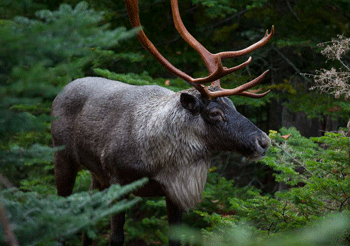
There are two ecotypes of woodland caribou in Ontario, which are referred to by their primary habitat: forest- dwelling woodland caribou and forest-tundra woodland caribou. The forest-dwelling boreal population of woodland caribou (Rangifer tarandus caribou) (referred to as “caribou” in this document), is listed as a threatened species under the Endangered Species Act, 2007 (ESA). As a threatened species, caribou receive both species and habitat protection. This means that harming caribou or damaging their habitat is prohibited.
The ESA requires that recovery strategies and government response statements are prepared within prescribed timelines for species listed as endangered or threatened. In 2008, the Recovery Strategy for the Woodland Caribou (Rangifer tarandus caribou) (Forest-dwelling, Boreal population) in Ontario (Ontario Woodland Caribou Recovery Team 2008) was finalized, providing scientific advice to the Minister of Natural Resources and Forestry on how to protect and recover caribou populations in Ontario. The government response statement to that recovery strategy was Ontario’s Woodland Caribou Conservation Plan (the CCP) (MNR 2009). The CCP outlines the government’s goal for the recovery of caribou. It identifies actions that the then Ministry of Natural Resources (MNR), now the Ministry of Natural Resources and Forestry (MNRF), intends to take to conserve and recover caribou in Ontario.
Ontario’s woodland caribou conservation goal
To maintain self-sustaining, genetically-connected local populations of woodland caribou (forest-dwelling boreal population) where they currently exist, improve security and connections among isolated mainland local populations, and facilitate the return of caribou to strategic areas near their current extent of occurrence.
The ESA requires a report of progress towards the protection and recovery of a species five years after publishing the government’s response statement. In addition, the CCP includes a policy commitment to developing a “State of the Woodland Caribou Resource Report” in 2014. This document meets both legislative and policy requirements.
Ontario’s Woodland Caribou Conservation Plan Progress Report (Progress Report) (MNR 2012) shares information on the accomplishments achieved in the three years since the release of the CCP. This document includes and builds on the achievements outlined in the Progress Report. While not a review or revision of the CCP, the State of the Woodland Caribou Resource Report reports on the actions the MNRF committed to in the CCP and provides a thorough overview of initiatives undertaken towards the protection and recovery of caribou. The report is divided into three parts:
Part one: Reports on MNRF’s more than 11 million dollar investment on progress made towards recovery actions and commitments in the CCP, including reporting on the status of policy, planning and resource management commitments.
Part two: Provides technical details and communicates key findings of the monitoring and assessment of caribou within Ontario’s Continuous Distribution (except Lake Superior Coast Range); describes the distribution of caribou and summarizes the findings from the initial Integrated Range Assessments.
Part three: Gives a technical summary of information on MNRF’s extensive Collaborative Provincial Caribou Research Program that discusses the findings of research commitments under the CCP.
Each part of the report can be read independently of the others but is still part of the State of the Woodland Caribou Resource Report. Additional supporting information can be found in the Appendices for each part.
Executive summary
Caribou are native to the province’s northern forests, and are an important indicator of the health of the boreal forest ecosystem on which they rely. Since the late 1800’s, the area where caribou once lived has receded by as much as 40 to 50 percent, with most of this recession happening early in this period. MNRF invested in generating new information and knowledge about caribou and their habitat through the support of the Collaborative Provincial Caribou Research Program (the Research Program). The researchers who planned, implemented and led the Research Program included representatives from MNRF, Canadian Forest Service, the University of Guelph, Trent University and Forest Ecosystem Science Co-operative Inc. Our understanding of caribou has greatly improved through the Research Program’s projects, monitoring and assessments, which allows for more informed decision making and for science-based advice to be incorporated into caribou policy in Ontario. As we move forward, MNRF will continue to support caribou research to address identified knowledge gaps and update monitoring and assessments.
The CCP prescribes a range management approach to caribou conservation, and identifies local population ranges (ranges) as the appropriate biological scale at which to think about and make resource management decisions. From 2008 to 2013, MNRF set out to assess the condition of caribou and delineated 14 ranges across the Continuous Distribution. Then, MNRF looked at each range’s existing caribou information, its anticipated development pressure and logistical considerations to decide the priority for conducting Integrated Range Assessments. Assessments were first conducted on each range along the southern boundary of the Continuous Distribution of caribou, and then in the Far North of Ontario. MNRF has monitored caribou populations across the Continuous Distribution (with the exception of the Lake Superior Coast Range) using various methods, such as two-stage winter aerial surveys, recruitment surveys, GPS collar deployment and the collection of genetic material. This monitoring data was used to complete an Integrated Range Assessment Report for each range and to develop baseline information on population and habitat state, as well as to determine range condition.
The Range Management Policy in Support of Woodland Caribou Conservation and Recovery (‘Range Management Policy’) (MNRF 2014a), released in 2014, guides how the Range Management Approach is to be carried out to support MNRF’s conservation goal for caribou. How it is carried out involves the management of the cumulative disturbance on the landscape, the amount and arrangement of caribou habitat, and the specific habitat features that are important for caribou survival. The intent of this management approach is to maintain or move towards a range condition that is likely to support a self-sustaining caribou population.
Forest management planning and the CCP have many compatible goals. These include a continuous and predictable supply of mature forest that provides quality caribou habitat and multiple social, economic and environmental benefits to Ontario. Caribou based objectives have been in place in for almost 20 years for Forest Management Plans in the MNRF’s Northwest Region, while in the Northeast Region, caribou based objectives have more recently been implemented.
MNRF’s commitment to the protection and recovery of caribou has been ongoing and carried out through successful stewardship initiatives funded through the Species at Risk Stewardship Fund (SARSF). These initiatives have been led by Aboriginal communities and organizations, academic institutions, individual businesses, industrial organizations and non-governmental organizations. Caribou protection and recovery has also been carried out through the process of developing community-based land-use planning in the Far North area of Ontario and through engaging industrial sectors to develop best management practices.
MNRF has made significant investments and progress towards the protection and recovery of caribou. By improving our understanding of caribou populations and habitat, the province can enable economic development to proceed in a sustainable, measured way that continues to advance the protection and recovery of caribou in Ontario.
1 Review of progress towards the protection and recovery of caribou in Ontario
1.1 Introduction and background
1.1.1 Caribou in Ontario
Caribou are native to the northern forests in the province, and are an important indicator of the health of the boreal forest ecosystem on which they rely. Since the late 1800’s, the area where caribou once lived has receded by as much as 40 to 50 percent, with most of this recession happening early in this period (Schafer 2003, MNR 2009). Several factors have contributed to this. They include human-caused disturbances that fragment landscapes and change the nature and function of forests (e.g. loss of forest habitat to other uses, changesin forest composition, and hunting and predation pressures) and natural disturbances such as forest fires, wind and snow damage (Racey and Armstrong 2000).
The amount and arrangement of caribou habitat in Ontario’s boreal forest is constantly changing. Caribou need and use the entire landscape as it changes with forest succession and natural disturbances, even while much of the forest may be in an unsuitable condition for caribou at any one time. Caribou habitat includes large patches of mature forest, dominated by coniferous tree species such as black spruce and jack pine, whose location and extent shifts over time. Disturbances from fires, wind and insects can quickly change the amount and distribution of habitat components.
The CCP applies to the areas of Continuous and Discontinuous Distribution in Ontario (Figure 1). Caribou travel widely within the area of Continuous Distribution, and may be expected to occur anywhere within it over time, usually in association with larger areas of older conifer-dominated forest, peatlands or large lakes with islands. Caribou do not occur in many areas of the Discontinuous Distribution, as the landscape is currently less capable of providing habitat for caribou to meet all of its life requirements. However, the area of Discontinuous Distribution is important in achieving the goal of the CCP as it has the potential to provide connecting corridors and to support movement between the northern ranges of Continuous Distribution and the Lake Superior Coast Range.
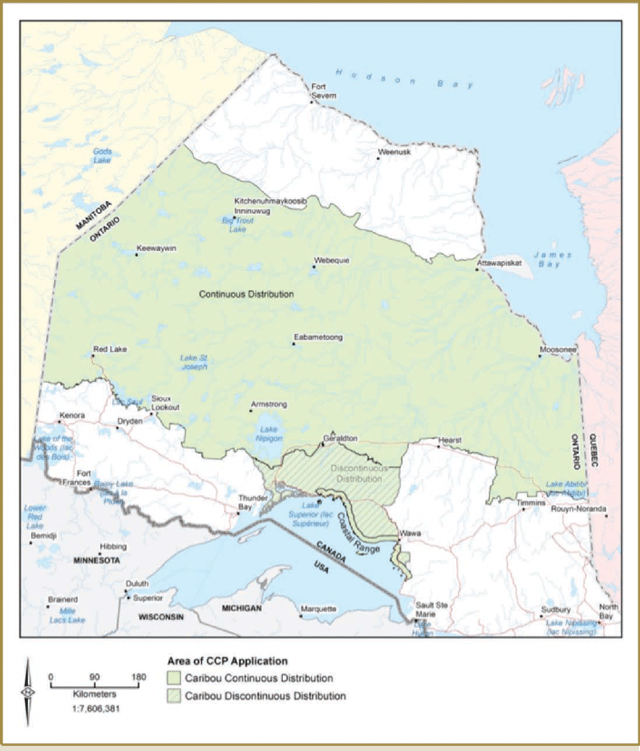
Enlarge Figure 1-1. Area of CCP application
1.1.2 Past initiatives to support protection and recovery of caribou in Ontario
Prior to the release of the CCP in 2009, MNRF undertook a number of initiatives that have contributed to the conservation and recovery of caribou in the province. These actions are outlined in Appendix 1-1.
1.2 Progress made towards individual CCP actions
1.2.1 Enhance caribou science (CCP 1.0)
Through the Collaborative Provincial Caribou Research Program, MNRF has gained extensive new knowledge about caribou and their habitat in Ontario, allowing for more informed decision-making in the province.
MNRF has invested significantly in one of the most comprehensive research programs in Canada with the goal of generating new information and knowledge about caribou and their habitat. New knowledge generated through this research helped inform policy development and will help inform decision-making in the province.
1.2.1.1 Collaborative provincial caribou research program
A group of researchers with representatives from MNRF, Canadian Forest Service, the University of Guelph, Trent University and Forest Ecosystem Science Co-operative Inc. planned, carried out and led the Collaborative Provincial Caribou Research Program (Research Program). The central goal of the Research Program has been improved understanding of factors that affect caribou viability (ability to survive and flourish). However, research efforts are also directed towards addressing recovery actions and commitments in the CCP and testing assumptions about caribou habitat, as in the Forest Management Guide for Boreal Landscapes (the Boreal Landscape Guide) (OMNR 2014).
Through the Research Program, MNRF researchers have contributed to over 50 different caribou research projects that are now completed or are ongoing in Ontario. These projects have generated new and exciting information about caribou and their habitat and have resulted in the submission and publication of several peer-reviewed journal articles, as well as Master’s and PhD theses.
The different research projects can be divided into three major groups. Several projects addressed specific CCP commitments, tested various policy assumptions or evaluated the effectiveness of different management approaches. Another set of projects focused on evaluating support for a series of alternative hypotheses about mechanisms that influence caribou persistence (e.g. predator road use, cumulative effects). A final set of projects focused on developing and applying models that can be used for caribou status assessments and to explore the potential impacts of different management and development scenarios.
Significant research findings include the following:
Population structure
There are clear behavioural distinctions between forest-dwelling and forest-tundra woodland caribou ecotypes, although there is overlap in areas used (particularly in winter). Caribou are distributed in a fairly continuous manner across the Ontario Shield Ecozone; however, there is some genetic behavioural and demographic evidence for structuring between groups.
Monitoring and assessment techniques
Population estimation may be feasible in some situations (e.g. small, isolated groups), while alternative methods vary in cost and effectiveness. When population estimation is not feasible or information on spatial distribution is required, occupancy modelling can be a valuable monitoring and assessment tool.
Caribou habitat
Where caribou choose to live appears to reflect the availability of forage (food sources) and the means to avoid the risk of predators. Conifer-dominated forests and treed lowlands have year-round importance. Caribou generally avoid habitats associated with greater risk of predation or sensory disturbance (i.e., noise), including regenerating disturbance, deciduous and mixedwood forests, settled areas and roads. Individual caribou exhibit traditional use (i.e., repeated preference or fidelity) to sites and ranges used at different times of the year, but fidelity is strongest to calving sites and ranges and weakest for winter ranges.
Caribou energetics and health
Lichens (particularly ground species) are the most important year-round part of caribou diets, but they have relatively low nutritional value. Lichen abundance is influenced by forest composition and their placement and age. The amount of energy used by caribou is strongly influenced by local environmental conditions (e.g. food availability, snow depth and temperature) and daily movement rates. Calf and adult condition data were limited, but preliminary evidence suggests caribou may be experiencing a lack or degradation of food sources in some managed areas. 3
Caribou relationships with alternate prey and predators
There is a high level of overlap between wolves and moose and a high degree of separation (in space and time) between caribou and both of these species. Research indicated that moose and wolf densities were higher in managed landscapes and wolf territories were smaller. Moose were the primary year-round prey of wolves and wolves selected forest types with higher moose density (i.e., mixed wood, deciduous or regenerating forests). Wolves also selected resource access roads and road use was linked to greater hunting success. While caribou are only moderately important to wolves as prey, wolf predation appears to be the major cause of adult caribou deaths and the number of deaths due to predation appears somewhat higher in more intensively managed areas.
Sensory disturbance
Caribou avoid settled areas (possibly due to associated noise). The tendency of caribou to avoid roads appears to get stronger when the amount of vehicle traffic rises above a certain level. Research indicated that caribou generally avoided being close to or crossing a major road or one with higher traffic volumes.
Some general management considerations based on research findings are as follows:
Forest management
General caribou-habitat relationships appear consistent with those assumed under current conservation and management approaches. Forest Management Plans must contain objectives that promote regeneration of future caribou habitat in amounts and arrangements that are similar to what occurs naturally.
At a finer scale, forestry practices have the potential to influence characteristics that are associated with greater amounts of lichen (i.e., the main caribou food item) when applied to appropriate sites (e.g. with sandy soils), although some silviculture (tree and forest care) techniques are more effective others.
Roads
Roads with low levels of vehicle traffic likely present more of a predation risk to caribou; however, caribou also avoid busier roads, likely due to the risk of traffic- related disturbances. Reducing the impacts on caribou of lower traffic-volume roads could mean minimizing road footprints at the landscape scale, locating roads in areas with low habitat value and, where possible and practical, decommissioning and reclaiming (e.g. closing off and planting over) roads that are no longer in use. Decommissioning could also reduce impacts on caribou of higher-traffic roads, as well as locating roads in areas of low habitat value and /or close to natural divisions.
Human activities
Dumpsites can serve as a major food source for wolves and thus, they may support higher wolf densities and increase predation risk for caribou. Potential management strategies for reducing the impacts of dumpsites on caribou include minimizing the number and size of dumpsites, and locating dumpsites in areas with low habitat value. Settlements are avoided by caribou, thus, efforts should be made to locate new settlements (e.g. work camps) in areas with low habitat value.
1.2.1.2 Species at Risk Research Fund for Ontario projects
The Species at Risk Research Fund for Ontario (SARRFO) is intended to support the protection and recovery of Species at Risk in Ontario by providing funding to high quality scientific research that addresses key threats, knowledge gaps and informs better species protection and management. Since 2009, MNRF has invested over $78,000 towards eight projects funded through SARRFO that support caribou conservation and recovery, including:
- Developing a tool for rapid assessment of caribou habitat based on site fidelity;
- Developing a statistical package to conduct probability of occurrence analyses and mapping;
- Identifying regional genetic differentiation, diagnostic variation and selection processes;
- Integrating advanced remote sensing techniques and multi-scale habitat assessment; and,
- Predicting the effects of climate change and habitat alteration on caribou distribution.
1.2.1.3 Monitoring the Caribou in Ontario
MNRF has monitored caribou populations across the Continuous Distribution (with the exception of the Lake Superior Coast Range) using various methods, such as two- stage winter aerial surveys, recruitment surveys, GPS collar deployment and the collection of genetic material. Because caribou are distributed sparely across large areas of land and are difficult to detect in dense conifer forests, it is necessary to use a variety of methods to estimate their numbers in a particular range and determine whether those numbers are increasing or decreasing.
This monitoring data was used to complete an Integrated Range Assessment for each range and develop baseline information on population, habitat state and range condition, which supports the implementation of the Range Management Policy in Support of Woodland Caribou Conservation and Recovery 4 between local groups or caribou ranges. (Range Management Policy) (MNRF 2014a). Integrated Range Assessment Reports (IRARs) (MNRF 2014d-k) were produced for all ranges that were surveyed. See section 1.2.2.2 for more information on these IRARs, and for detailed information, see Part 2 of this report.
1.2.1.4 Provincial woodland caribou database
The Provincial Woodland Caribou Database was identified in the CCP as an important initiative. It supports caribou recovery by providing access to all caribou survey, observational, collaring, and occurrence information for the province. It addresses the need for a comprehensive spatial database to support population, and for habitat monitoring as well as policy and legislative development and evaluation. All caribou data is now part of the Natural Heritage Information Centre’s (NHIC) authoritative datasets and are located in Land Information Ontario (LIO), the Ontario government’s corporate database structure for managing geographic information. These datasets (GIS data layers) are accessible through the LIO warehouse by contacting lio@ontario.ca.
These centralized datasets provide valuable information about caribou and about areas of importance to caribou in Ontario. Information in the datasets includes survey and project details and identifies areas surveyed for caribou during both aerial and ground surveys. It also documents the presence or absence of caribou in areas through direct and indirect observations (actual animals and such signs as tracks, pellets, etc.). Datasets include detailed location data obtained from collared caribou. Public and casual observations are also stored here and may include road/rail kills or other known, human-caused individual caribou deaths.
The information in the datasets provides opportunities to identify important areas for caribou (occurrences) such as nursery areas, winter use areas, travel corridors, seasonal ranges, and other areas as defined in the General Habitat Description for the Forest-dwelling Woodland Caribou, (General Habitat Description) (MNR 2013a). It will help inform land use and resource management planning and decision-making. The datasets also aid in identifying gaps in survey coverage and help direct future research.
Many development activities, such as forestry, mining and mineral exploration and renewable energy projects are ongoing and require readily available, comprehensive information in order to address caribou conservation.
Together with the Caribou Screening Tool (CST), which is described in further detail in Section 1.2.3.1, the database provides resource managers with enhanced information about caribou occupancy and the cumulative impacts of resource development on caribou and their habitat.
1.2.1.5 Provincial Caribou Technical Committee
The Provincial Caribou Technical Committee (PCTC) was established in 2010 as a standing committee, whose purpose is to provide scientific and technical advice on the implementation of the CCP. Members are recognized scientific and technical experts in their fields, which include caribou ecology, forest ecology, conservation biology and forest management.
PCTC members have provided strategic, scientific and technical advice to the MNRF during the development of products and programs, including the Delineation of Woodland Caribou Ranges in Ontario (Range Delineation Report) (MNRF 2014b), the Integrated Assessment Protocol for Woodland Caribou Ranges in Ontario (the Protocol) (MNRF 2014c), Integrated Range Assessments Reports (IRARs) (MNRF 2014d-k), CST, General Habitat Description (MNR 2013a), Range Management Policy (MNRF 2014a) and this report. Additionally, the committee has provided MNRF with advice pertaining to caribou conservation in the Far North area of Ontario.
1.2.1.6 Priorities and next steps for CCP implementation
Continuation of the caribou research
- MNRF will continue to support caribou research to address identified knowledge gaps.
Ongoing Species at Risk Research Fund for Ontario (SARRFO)
- Funding will continue to be available for eligible research projects that support the protection and recovery of caribou in Ontario as per the SARRFO Guidelines.
Future monitoring and assessment
- MNRF will continue to collect important information through future monitoring and assessment projects that provide new information and insight into caribou ecology and habitat use.
Integrating Caribou Data into Land Information Ontario (LIO)
- MNRF will continue to ensure that the enduring quality and currency of caribou data is maintained. All new caribou data sponsored or funded by MNRF and, where possible, funded privately will be entered into the appropriate layers in LIO. This is essential to securing the investment from both past, current and future data collection initiatives.
1.2.2 Adopt a Range Management Approach (CCP 2.0)
MNRF has released a Range Management Policy in Support of Woodland Caribou Conservation and Recovery that provides guidance on the implementation of the Range Management Approach.
The Range Management Policy, released in 2014, provides guidance on carrying out the Range Management Approach to support achievement of MNRF’s conservation goal for caribou. This involves the management of cumulative disturbance, habitat amount and arrangement, and sub- range habitat features. The intention is to maintain or move towards a sufficient range condition, which ultimately influences the sustainability of a caribou population.
As defined by the Range Management Policy (MNRF 2014a), ranges set the spatial and ecological context for planning and resource management decisions. The Range Management Policy builds on the CCP, and describes an approach that includes:
- Delineating caribou ranges within the area of Continuous Distribution;
- Conducting an Integrated Range Assessment and documenting range condition;
- Integration of Range Management Policy principles (cumulative disturbance, habitat amount and arrangement and sub-range habitat features) into planning and decision-making to meet the Range Management Policy objective; and
- Regular monitoring, evaluation and reporting on Range Management Policy implementation.
1.2.2.1 Caribou range delineation in the continuous distribution
In Ontario, the majority of caribou are broadly distributed across the boreal forest. While wholly discrete, spatially disjunct (physically separated) populations of caribou have been identified in other jurisdictions (EC 2012), with the exception of animals occupying the Lake Superior shoreline and a number of adjacent islands, there are there are none in the province of Ontario.
Ranges were delineated within the Continuous Distribution in two stages. Eight ranges along the southern edge (including one Lake Superior Coast Range) were completed during and following the development of the CCP, as these were a priority for addressing the protection and recovery of caribou along the southern extent of their distribution in Ontario. An additional six ranges, as well as a new northern boundary, were delineated in the northern portion of the Continuous Distribution in 2013 (Figure 2).
The southern boundary of the Northern Taiga Ecoregion (1E) (Crins et al.. 2009) was used as the new northern boundary for the Continuous Distribution and the constituent ranges along that edge. Recent research (Berglund et al.. 2014) suggests that the southern boundary of the Northern Taiga Ecoregion (1E) is a reasonable, ecologically based approximation of the northern range limit for this ecotype. This boundary could inform changes that correspond to the Boreal Caribou (DU6) and Eastern Migratory (DU4) Designatable Units, as identified by the Committee on the Status of Endangered Wildlife in Canada (COSEWIC 2011). For information on this see the Range Delineation Report (MNRF 2014b).
The Protocol (MNRF 2014c) describes the process for conducting assessments of the status of caribou populations and habitat within each range, and includes the criteria used for delineating ranges. This approach was adapted from the Scientific Review for the Identification of Critical Habitat (Environment Canada 2008), which supports the federal Recovery Strategy for the Woodland Caribou (Rangifer tarandus caribou), Boreal population, in Canada (‘Federal Recovery Strategy’) (EC 2012). Criteria were applied collectively and in order of priority, including:
- Animal movement and animal survey data
- Spatial extent
- Evidence of shared geography
- Habitat functions and behavioural responses
- Predominant risk factors
- Conformity to existing ecological or administrative boundaries
The Range Delineation Report (MNRF 2014b) documents the delineation of 14 ranges within the Continuous Distribution, based on the above criteria and the delineation of the Discontinuous Distribution. The Range Delineation Report provides rationale for boundary changes between now and when the CCP was released. Detailed descriptions of the specific range boundaries using metes and bounds are included.
Range delineation was based on best available knowledge at the time it was completed. As described in the Range Management Policy, range boundaries will be evaluated periodically, and will consider new information obtained through research studies and Integrated Range Assessments. This information may include population surveys, assessments of population health, animal movement patterns and seasonal habitat selection.
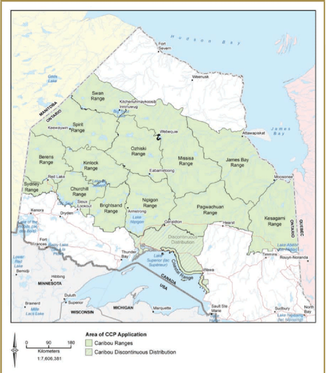
Enlarge Figure 1-2. Caribou ranges in Ontario
1.2.2.2 Range condition
The CCP outlined that an Integrated Range Assessment would be conducted for each range. Each assessment follows the Protocol and is documented in an Integrated Range Assessment Report (IRAR). The Integrated Range Assessment involved an evaluation of four quantitative (or numbers based) lines of evidence, two relating to caribou population state (size and trend) and two relating to habitat state (disturbance, and amount and arrangement of habitat) that inform the determination of range condition.
Range condition is expressed along a continuum representing the relative ability of a range to support a self-sustaining caribou population. This continuum references three broad categories of range condition (a) range condition is sufficient to sustain caribou; b) uncertain if range condition is sufficient to sustain caribou; c) range condition is insufficient to sustain caribou). The range condition can also be described in accordance with theline or lines of evidence that most influenced the range condition (e.g. range is insufficient to sustain caribou due to a declining population, large areas of disturbance, etc.).
Following the Protocol, MNRF has completed Integrated Range Assessments and determined range conditions for 13 ranges (Table 1). These Integrated Range Assessments are documented in IRARs (MNRF 2014d-k), which are available on the MNRF website.
The Protocol applies to all caribou ranges in the Continuous Distribution, acknowledging that data availability may vary across the province (for example, those in the Far North of Ontario). The Protocol exception is the Lake Superior Coast Range.
Table 1-1. Range condition for all ranges after completed Integrated Range Assessments
- Range condition: Range name
- Sufficient to sustain caribou:
- Swan, Ozhiski
- Uncertain if range condition is sufficient to sustain caribou:
- Berems, Churchill, Nipigon, Pagawachuan, Spirit, Kinloch, Brightsand, Missisa, James Bay
- Insufficient to sustain caribou:
- Kesagami, Sydney
- Sufficient to sustain caribou:
Detailed discussion of monitoring and assessment activities can be found in Part 2of this document. An IRAR has not been completed for the Lake Superior Coast Range, or the Discontinuous Distribution, but background information was gathered and includes current and historic distribution of caribou, abundance and population trends, habitat requirements, current topography and forest conditions, the current resource management planning direction, current disturbances on the landscape and available Aboriginal Traditional Knowledge.
1.2.2.3 Planning and decision-making
Planning and resource management decisions are typically made on a case-by-case basis, potentially influencing the ecological function of one or more sub-range habitat features. These decisions can collectively result in a caribou demographic response and ultimately influence range condition (i.e., impacts to caribou population and habitat condition). The Range Management Policy (MNRF 2014a) provides direction on the consideration of range condition during planning and decision-making. Range condition informs the relative tolerance of the range to alteration and the determination of the risk that a particular activity could pose for caribou.
1.2.2.4 Working with other jurisdictions
The federal Recovery Strategy (EC 2012) requires the preparation of range plans to outline how range-specific land and/or resource activities will be managed over space and time to ensure that critical habitat for boreal caribou is protected from destruction. Implementation of the Range Management Approach, as described in the Range Management Policy (MNRF 2014a), will constitute range plans that consider the requirements and direction in the federal Recovery Strategy and the protection of critical habitat under the federal Species at Risk Act.
The National Boreal Caribou Technical Committee is made up of Federal, Provincial and Territorial representatives, including Ontario. This group provides guidance on the application of criteria set out in the National Recovery Strategy. As a member of this committee, MNRF has presented information on the Range Management Approach to other jurisdictions in Canada. This included sharing knowledge on how the Range Management Approach is implemented within existing resource management planning processes and discussing opportunities and different approaches for the protection and recovery of caribou in Ontario.
1.2.2.5 Priorities and next steps for CCP implementation
- Implementation of Range Management Policy
- MNRF will use the Range Management Policy when making resource management and land use planning decisions. MNRF will engage federal and provincial agencies, organizations, individuals and communities to increase awareness of the Range Management Policy and promote its consideration and application in decision- making outside of MNRF’s mandate.
- Review of caribou range boundaries
- As part of an adaptive management framework, caribou ranges will undergo periodic review and evaluation to determine if boundary adjustments are required to better support the implementation of the Range Management Policy.
- Ongoing Integrated Range Assessments
- Integrated Range Assessments will be used to evaluate implementation success through the monitoring of caribou and habitat states. The prioritizing and scheduling of future Integrated Range Assessments will consider time since the last Integrated Range Assessment was completed, the availability of new knowledge, and range condition.
- Ongoing collaboration with other jurisdictions
- MNRF will continue to encourage information sharing across jurisdictional boundaries.
1.2.3 Improve planning (CCP 3.0)
The Range Management Approach is considered and applied during land use and resource management planning. MNRF has developed policy documents to act as planning tools to help assess the implications of various resource development proposals on caribou.
Resource management and land use decisions that support the goal of the CCP are facilitated through the application of the Range Management Approach through the implementation of the Range Management Policy. MNRF considers range condition, habitat categorization and activity details in all planning and resource management decisions under its authority. The status of the range condition, the application of the General Habitat Description and activity details associated with a proposal when considered together help guide resource management decisions.
1.2.3.1 Range management and the Caribou Screening Tool (CST)
The Range Management Policy (MNRF 2014a) provides guidance for reviewing activities and assessing them for potential adverse effects on caribou and their habitat. It also describes how the CST can be used to support the assessment of those potential adverse effects. The CST is an analytical tool that tracks ongoing cumulative disturbance. It provides a consistent method of screening activity proposals against caribou values in each of the caribou ranges. It is an effective tool for comparing multiple scenarios and alternatives to a given proposal. A comprehensive disturbance GIS data layer was developed for the Integrated Range Assessment process; this disturbance layer is used in CST to support the tracking of disturbance across ranges.
MNRF has implemented general habitat protection for caribou since June 30, 2013. The General Habitat Description (MNR 2013a) provides clarity on this subject, including how habitat has been categorized to reflect its importance at multiple spatial and temporal scales. Habitat has been categorized into high-use areas (nursery areas, winter use areas, and travel corridors), seasonal ranges, and the remaining areas within the range.
The Range Management Policy enables MNRF to produce, where necessary, additional, activity-specific operational guidance regarding the integration of the Range Management Policy into various planning and resource management processes under its mandate (e.g. Protected Area Planning under the Provincial Parks and Conservation Reserves Act, Forest Management Planning under the Crown Forest Sustainability Act, etc.).
1.2.3.2 Crown land use policy atlas
As part of the CCP, the Crown Land Use Policy Atlas (CLUPA) was updated to reflect caribou presence and the need for additional consideration of caribou. CLUPA is the source of area-specific land use policy for Crown lands and applies to a large area within the Continuous Distribution. Individual Policy Reports that are developed as part of CLUPA are currently being amended to indicate if the area falls entirely or partially within the area of application of the Range Management Policy. The Interactive map browser is a major component of CLUPA and has been updated to include caribou range boundaries as a mapping layer that can be turned on for viewing.
1.2.3.3 Best management practices
MNRF has released a series of four Best Management Practices (BMPs) (MNR 2013 b-d, MNR 2014) that address mineral exploration and development, renewable energy, tourism and aggregate activities in caribou habitat. For more details on the specifics of these BMPs, see Section 1.2.7.1.
The BMP series can be used in all phases of resource development activities to explore options to comply with the ESA (i.e. that a given activity will have no adverse effects on caribou or their habitat). The BMPs describe techniques, methods, or processes that can be applied to avoid or mitigate adverse effects, reduce threats to caribou when planning or undertaking activities within a range, and contribute to achieving the objective of the Range Management Policy.
1.2.3.4 Priorities and next steps for CCP implementation
- Implementation and use of the Caribou Screening Tool
- The CST will continue to be instrumental in allowing stakeholders and MNRF to make informed decisions with respect to caribou conservation. The CST will be maintained and updated with best available information and applied in activity review assessments.
- Implementation and use of the Best Management Practices
- The BMPs will continue to be recommended for use in all phases of resource development activities to make informed decisions with respect to caribou conservation.
1.2.4 Enhance caribou habitat (CCP 4.0)
MNRF has improved direction for forest management planning and caribou. Additionally, MNRF has enabled consideration of caribou habitat values during the planning of fire management operations.
1.2.4.1 Forest management planning
Through MNRF's forest management planning process, forest managers ensure that forest management plans include both socio-economic and biodiversity objectives, with the long-term viability and sustainability of forest-based communities and businesses second only to the sustainability of the forest ecosystems.
Ontario’s forest industry requires a continuous and predictable wood supply with a high conifer component in the boreal forest. Renewing large, even-aged tracts of forest, provides for efficient harvesting blocks for the forest industry, while supporting caribou habitat needs in the future. Since the early 1990’s active caribou habitat management has been occurring in MNRF’s Northwest and Northeast Regions. In the Northwest, this was done through implementation of the Forest Management Guidelines for the Conservation of Woodland Caribou: A Landscape Approach (‘Caribou Guide’) (Racey et al. 1999). The Caribou Guide utilized a landscape mosaic approach for harvesting, which emulated the landscape pattern of large even-aged forest patches created by wildfire. This was intended to reduce forest fragmentation, reduce road density and maintain large even-aged mature coniferous forest areas on the landscape. Forest management is also used to defragment and restore potential future habitat for caribou (OMNR 2008). In the Northeast, caribou habitat was being managed by deferring harvest blocks for 40 to 60 years. The aim has been to maintain suitable habitat for caribou until adjacent areas were restored and could once again be considered caribou habitat (OMNR 2008).
Since the release of the CCP, caribou mosaics and deferral blocks have been replaced by a Dynamic Caribou Habitat Schedule. A Dynamic Caribou Habitat Schedule is a long- term plan for the provision of sustainable year-round caribou habitat in very large interconnected habitat tracts that are implemented through the forest management planning process. A Forest Management Plan outlines the long-term objectives for forest harvest, renewal and tending, road use management strategies, and biodiversity objectives within acceptable limits of habitat supply and population persistence (MNR 2009). A Dynamic Caribou Habitat Schedule is based on the premise that harvested areas that provided suitable habitat can be regenerated using appropriate silviculture techniques to provide future caribou habitat. All Forest Management Plans in the Continuous Distribution, where applicable, have incorporated actions for the conservation of caribou as described in the CCP.
The Boreal Landscape Guide was developed with the professional support and input provided by forest industry as the result of many workshops, meetings, informal communications and comment on the posted guide on the Environmental Bill of Rights (EBR) registry. It was also developed with thoughtful and constructive advice from the Provincial Forest Technical Committee (PFTC). The role of the PFTC is to provide advice to the Assistant Deputy Minister of Policy Division.
All Forest Management Plans that are approved in 2017 will fully implement the Boreal Landscape Guide. The Boreal Landscape Guide directs forest management activities to maintain or enhance natural landscape structure, composition and patterns for biodiversity conservation, including the provision of habitat for a Species at Risk such as caribou. Following the direction in the Boreal Landscape Guide will be an integral component of achieving the goal of the CCP. Habitat tract based Dynamic Caribou Habitat Schedules are completed for each Forest Management Plan by applying the direction for caribou in the Boreal Landscape Guide, the Science and information Package (Elkie et al. 2013). This package includes estimates of disturbance, habitat and young forest. Collectively these estimates provide forest managers with current estimates of landscape conditions (cumulative impact assessment) needed to make management decisions that support the implementation of the CCP.
Enhanced silviculture effectiveness monitoring (eSEM) to assess future caribou habitat
To inform future efforts that ensure harvested areas are moving toward a suitable future habitat condition for caribou, MNRF supported enhanced silviculture effectiveness monitoring (eSEM) for caribou habitat renewal. The eSEM program objective was to evaluate past forest renewal activities and produce results that would supplement the core SEM data collected by MNRF staff. This program was completed over three years and included plot- based surveys of young renewal blocks from five to fifteen years post-disturbance. Fifteen Forest Management Units were included in the surveys with work being carried out on six of the seven caribou ranges that intersect the Area of Undertaking. Results of analyses will be provided to forest management planning teams as they are completed.
1.2.4.2 Wildland fire management
Ontario’s ecosystems have evolved with fire and depend on it for renewal and maintenance. Fire is a natural force that sustains the cycle of growth, death and re-growth. Wildland fire is a frequent presence in the boreal forest and plant species have adapted to a fire-driven disturbance regime.
Many ecosystems important to meeting the life requirements of caribou benefit from fire in their renewal. Guidance in the Range Management Policy is consistent with the Draft Wildland Fire Management Strategy for Ontario (Draft Fire Management Strategy) (MNRF 2014l).
The Draft Fire Management Strategy (MNRF 2014l) enables the management of fire to perform ecological functions; in other words, the provision of future caribou habitat where feasible. During management planning, the Draft Fire Management Strategy helps to identify and protect important values on the landscape, including important elements of species-at-risk habitat. It enables MNRF to effectively use, where appropriate, prescribed burns and fire management to meet ecological and resource management objectives (i.e., the provision and renewal of caribou habitat).
1.2.4.3 Priorities and next steps for CCP implementation
Forest management planning for Ontario’s crown forests
- MNRF will continue to engage stakeholders regarding the linkages between the Crown Forest Sustainability Act (CFSA) and the ESA. MNRF will continue to support implementation of the Range Management Policy with all affected industries including the forest sector.
1.2.5 Manage the wildlife community (CCP 5.0)
MNRF considers the broader wildlife community when working to protect and recover caribou.
1.2.5.1 Wildlife management programs
MNRF considers the broader wildlife community, including moose, deer, wolves, and bears, while working to protect and recover caribou and provide for movement towards self- sustaining caribou populations.
Caribou live in a very sensitive balance with predators such as the Gray Wolf and Black Bear in the boreal forest, and caribou numbers have been shown to decline with higher predator density. Research has shown that increasing the number of other cervids (antlered animals), such as deer, moose, and elk, will also lead to an increase in the population of caribou predators. As discussed in Section 1.2.4.1 of this document, the main tools for managing wildlife habitat are MNRF’s forest management planning guides (e.g. Boreal Landscape Guide). If habitat is managed to reduce suitability for other cervids, primarily through forest management planning, the capacity of the landscape to support predators is also reduced.
MNRF recognizes that individual species are part of complex ecosystems. While management decisions are often directed at certain species, these decisions are made in the context of the entire ecosystem.
Several actions with other wildlife management programs are ongoing. These address broader wildlife management related to caribou protection and recovery and include:
- The Cervid Ecological Framework (OMNR 2009), which provides a strategic framework to improve coordinated cervid management decisions;
- New hunting seasons that were implemented for white- tailed deer across all northern Wildlife Management Units, including 1C, 16A, 16B, 17, 2, 3, 4, 11B, 13, 14, 15A, 15B, 18A, 18B, 19, 21A, 5, 21B, 22, 23, 24, 25, 26, 27, 30 and 34;
- Hunter questionnaires about the number of white-tailed deer and wolves seen while hunting moose in northern Ontario, which help to monitor relative deer and wolf distribution and abundance; and
- MNRF, in collaboration with Pukaskwa National Park (Parks Canada) conducted on a review of the feasibility of caribou translocations, in order to augment the size of the caribou population that lives in the vicinity of Pukaskwa National Park.
1.2.5.2 Priorities and next steps for CCP implementation
Human-caused mortality
MNRF will look at approaches for consideration of human-caused mortality; for example, MNRF will hold pilot discussions with Ontario Provincial Police, Ministry of Transportation, Canadian Pacific Railway Limited about considering potential impacts of vehicular mortality.
1.2.6 Focus on geographic priority areas (CCP 6.0)
MNRF prioritized the Integrated Range Assessments based on the most at-risk local population ranges.
Integrated Range Assessments were done in order of priority. Caribou ranges were prioritized based on criteria such as existing the caribou information, anticipated development pressure and logistical considerations for each range. The southern ranges of the Continuous Distribution (with the exception of Lake Superior Coast Range) were assessed first, as they were thought to have the most urgent conservation needs. This was followed by assessments of ranges in the Far North of Ontario.
1.2.6.1 Integrated Range Assessments
The schedule of Integrated Range Assessments of the southern ranges was influenced by factors including:
- Development pressures;
- Overlap with research study sites in the Nipigon and Kesagami ranges; and,
- Efficient allocation of resources for completing field assessments.
The following schedule identifies the order in which the Integrated Range Assessments were initiated based on prioritized areas:
- 2010: Nipigon and Kesagami
- 2011: Brightsand and Pagwachuan
- 2012: Churchill, Sydney and Berens
- 2013: Kinloch, Spirit, Swan, Ozhiski, Missisa, and James Bay
Integrated Range Assessments were not completed for the Discontinuous Distribution or Lake Superior Coast Range and the Range Management Policy does not apply to these areas. However, background information was gathered about caribou in these two areas. It includes current and historic distribution of caribou, abundance and population trends, habitat requirements, current topography and forest conditions, current resource management planning direction, current disturbances on the landscape, and available Aboriginal Traditional Knowledge.
1.2.6.2 Priorities and next steps for CCP implementation
Ongoing Integrated Range Assessments
Integrated Range Assessments will be used to evaluate implementation success through the monitoring of caribou population and habitat states. In future, prioritizing and scheduling of Integrated Range Assessments will take into account the elapsed time since the last Integrated Range Assessment was completed, the availability of new knowledge, and range condition.
1.2.7 Improve outreach and stewardship (CCP 7.0)
MNRF has increased awareness about caribou conservation amongst the general public, proponents, and Aboriginal communities.
Outreach on the CCP was initiated before it was released in 2009. MNR met with many communities, conservation and environmental organizations, resource development sectors, and Aboriginal communities and organizations to discuss how to best implement the CCP to ensure its objectives are met. These outreach initiatives helped to increase awareness of caribou ecology and conservation practices.
The Progress Report, published by MNR in 2012, gave an update of the accomplishments of the first three years of CCP implementation. Additionally, general fact sheets were produced that discuss habitat requirements, distribution, threats, protection provisions and “What you can do to help woodland caribou”.
1.2.7.1 Best management practices sector engagement
During the development of the BMP Series, consultation occurred with other ministries and stakeholders and advice was provided by the PCTC.
- Best Management Practices for Mineral Exploration and Development Activities and Woodland Caribou in Ontario (MNR 2013b) is consistent with the Modernization of the Mining Act and incorporated input from the Ministry of Northern Development and Mines, the Ontario Mining Association and Ontario Prospector’s Association.
- Best Management Practices for Renewable Energy, Energy Infrastructure and Energy Transmission Activities and Woodland Caribou in Ontario (MNR 2013c) incorporates input from the Ontario Waterpower Association, Ontario Power Generation, and HydroOne.
- Best Management Practices for Tourism Activities and Woodland Caribou in Ontario (MNR 2013d) was produced with input from the Ministry of Tourism, Culture, and Sport.
- The Best Management Practices for Aggregate Activities and Woodland Caribou in Ontario (MNR 2014) was developed with input from the Ontario Sand, Stone, and Gravel Association.
1.2.7.2 Species at Risk Stewardship Fund
Since 2009, MNRF has contributed over $1.7 million to 27 projects to support its partners in achieving their effortstoward caribou conservation activities, through the MNRF’s Species at Risk Stewardship Fund (SARSF). Partners such as Aboriginal communities and organizations, academic institutions, individual businesses, industry organizations, and non-governmental organizations have all demonstrated their commitment to the protection and recovery of caribou in Ontario through the successful delivery of stewardship initiatives. Types of projects funded by SARSF include:
- Collection of Aboriginal Traditional Knowledge;
- Identification of caribou habitat in land use planning exercises;
- Calving surveys;
- Determination of caribou habitat use and movement;
- Enhanced Silviculture Effectiveness Monitoring;
- Enhancement of caribou habitat through prescribed burns and silviculture; and,
- Development of educational products for students.
Our Incredible World: Woodland Caribou in the Boreal Forest, funded for three years by the Species at Risk Stewardship Fund, will be made up of six 15-minute informative videos for youth, and are designed to educate and intrigue. These videos will focus on the complex relationship between caribou, predators and people within the boreal forest.
Throughout the series, youth investigators go on fact-fi adventures. They interview caribou researchers, forest industry representatives and Aboriginal elders to learn about the importance of the boreal forest to caribou and people. Comprehensive study guides for grades 4 to 10 will be available to ensure students fully benefi from the fi On- location fi in the boreal forest captures fi researchers doing their actual fi work (e.g. tracking and recovery of wolf collars, tracking caribou cratering sites and pellet gathering, exploring the boreal forest with a Cree Elder).
Along with the series, a new section called “Incredible Careers” is going to be added to Our Incredible World’s website. These will be short interviews, conducted by the youth investigators, of people who work in life sciences – an entomologist, a wildlife research analyst, a research scientist – all sparking interest in a career involving environmental stewardship.
The Nagagami Caribou Stewardship Project has been ongoing for the past six years and focuses on a potentially isolated population of caribou in the Nagagami Lake area of the Pagwachuan Range, near the southern extent of the species’ Continuous Distribution in Ontario. The project, originally funded by the Species at Risk Stewardship Fund, was initiated and led by the Northeast Superior Forest Community and the Northeast Community Network, who worked in partnership with MNRF for three years. This project is now led by the MNRF Hearst District with support from Constance Lake First Nation.
The project has included field-based habitat assessments, an evaluation of Lidar data for identification of caribou habitat, population and recruitment surveys, collaring and tracking caribou with satellite radio technology, genetic sampling, and community outreach. The initiative has resulted in the documentation of nursery areas, seasonal movements and mortalities and has led to an improved understanding of the movements and behaviours of caribou in this area. This enhanced understanding has enabled Ontario to make more informed decisions that support caribou conservation in the project area.
In 2011, Hearst Forest Management Inc. received funding through Species at Risk Stewardship Fund for a project to renew and enhance caribou habitat by conducting a prescribed burn. The burn took place in a 404 hectare area located in the Hearst Forest Management Unit that, at the time, was unsuitable for caribou. Prescribed burning is a cost-efficient method that can be used to manage less desirable species, such as balsam fir and trembling aspen, and help bring back stands to historical compositions of pure conifer. Subsequent planting, monitoring and tending of the site will bring the area back to a suitable condition to provide habitat for future use by caribou. In the future this site could provide an important north-south linkage for caribou.
1.2.7.3 Priorities and next steps for CCP implementation
Ongoing outreach and engagement
- MNRF will continue to engage Aboriginal communities, stakeholders and other Ministries in outreach initiatives to support the continued implementation of the CCP, as well as the implementation of the broader Species at Risk program.
Ongoing Species at Risk Stewardship Fund (SARSF)
- Funding will continue to be available for eligible projects that align with the CCP and support the protection and recovery of caribou in Ontario as per the SARSF Guidelines
1.2.8 Integrate Aboriginal traditional knowledge (CCP 8.0)
Knowledge and insight from Ontario’s Aboriginal peoples has informed the protection and recovery of caribou populations by facilitating the integration of caribou information into planning and decision-making, especially community based land use planning.
Aboriginal peoples have a special relationship with the land, and they have supported caribou conservation efforts by taking part in stewardship initiatives as well as being mindful of caribou and their habitat during community based land use planning in the Far North of Ontario.
1.2.8.1 SARSF projects conducted by Aboriginal communities and/or organizations
MNRF has provided over $220,000 to 11 projects since 2009, with six of the projects being undertaken in 2014– 2015. Five completed projects were aimed at gathering Aboriginal Traditional Knowledge (ATK) about caribou and their habitat and at increasing awareness of caribou in Aboriginal communities.
Lac Seul First Nation completed a three-year Woodland Caribou Summer Habitat Use Survey of Lac Seul, which was funded through the Species at Risk Stewardship Fund Program. Field crew members spent three summers scouring the shoreline and islands for evidence of calving activity, including tracks and pellets. The work completed assists the community and MNRF in understanding the level and extent of caribou use of the islands and peninsulas on Lac Seul for calving and nursery purposes.
Namaygoosisagagun Ojibways Development Corporation researched and presented information on caribou to Collins community members. They gathered ATK from elders regarding caribou habitats and populations within their traditional territory and presented the information back to the community in order to raise awareness of caribou in the area. The information was shared with the MNRF to help inform decision making and conservation efforts.
The Mushkegowuk Knowledge of Woodland Caribou and Stewardship Project is an ongoing multi-year project that aims to collect knowledge of caribou and other species at risk. This information will ultimately be mapped and used in caribou conservation initiatives, as well as during the Far North Land Use Planning process for the traditional territories of participating communities/First Nations. The project focuses on ATK collected from eight communities belonging to the Mushkegowuk Tribal Council.
Grand Council Treaty #3 is collecting ATK on caribou and wolverine in the northwestern portion of Treaty #3. The project aims to obtain current and historic distribution and relative population estimates by conducting interviews with elders, trappers, and knowledge holders in Wabaseemoong Independent Nations, Grassy Narrows First Nation, and Wabauskang First Nation.
Constance Lake First Nation has begun to collect all ATK work that has been conducted to date on caribou, including community surveys and project-specific reports. This information is being compiled to develop an ATK baseline for Constance Lake First Nation’s traditional territory. The community is working to identify and fill knowledge gaps by supplementing existing information with that gathered in interviews with knowledge holders and neighbouring First Nations. The aim is to paint a more complete picture of caribou in their traditional territory. A summary of information will be provided to MNRF to enable more informed resource management decision making.
1.2.8.2 Priorities and next steps for CCP implementation
Ongoing integration of Aboriginal traditional knowledge
- MNRF will continue to provide opportunities for incorporating ATK into caribou recovery through active engagement with Aboriginal communities, sharing information and continuing to support their stewardship activities. MNRF is committed to meeting constitutional obligations with respect to Aboriginal and Treaty Rights.
1.3 Conclusion
Since the release of the CCP, MNRF has worked closely with its partners and invested over 11 million dollars toward the protection and recovery of caribou. Numerous research projects have allowed MNRF to greatly expand our knowledge of caribou and the factors that influence their probability of persistence. Monitoring and assessment efforts have enabled comprehensive evaluation of the current state of caribou populations and habitat — two key components for the protection and recovery of caribou in Ontario. These advances in understanding caribou and their habitat have enabled the development of the Range Management Policy (and associated planning tools), which aims to support MNRF’s decision-making to keep it consistent with the CCP recovery goal. Looking forward, MNRF will focus on caribou policy implementation, while continuing to work with other jurisdictions and stakeholders, support research, monitoring and assessment priorities and encourage stewardship actions.
References
Bergerud, A.T. 1996. Evolving perspectives on caribou population dynamics, have we got it right yet? Rangifer 16(4):95-116.
Bergerud, A.T., S.N. Luttich, and L. Camps. 2008. The return of caribou to Ungava. McGill-Queens University Press, Montreal, Quebec.
Elkie, P. K. Green, G. Racey, M. Gluck, J. Elliot, G. Hooper, R. Kushneriuk and R. Rempel, 2013. Science and Information in support of Policies that address the Conservation of Woodland Caribou in Ontario: Habitat and Disturbance Models, Estimates of Natural Variation and Range Level Summaries. Electronic Document. Version 2013. Ontario Ministry of Natural Resources, Forest Policy Section.
Environment Canada (EC). 2008. Scientific Review for the Identification of Critical Habitat for Woodland Caribou (Rangifer tarandus caribou) Boreal Population, in Canada. August 2008. Environment Canada, Ottawa, Canada. 72 pp. plus appendices.
EC. 2012. Recovery Strategy for the Woodland Caribou (Rangifer tarandus caribou), Boreal population, in Canada. Species at Risk Act Recovery Strategy Series. Environment Canada, Ottawa. xi + 138 pp.. Government of Ontario. 2007. Endangered Species Act, 2007.
Land Information Ontario Warehouse (LIO). 2012. Lands Information Ontario Warehouse. Peterborough, Ontario: Ontario Ministry of Natural Resources.
Ministry of Natural Resource (MNR). 2009. Ontario’s Woodland Caribou Conservation Plan. Queen’s Printer for Ontario, Toronto Ontario, Canada. 24 pp.
MNR. 2012. Ontario’s Woodland Caribou Conservation Plan Progress Report.
MNR 2013a. General Habitat Description for Woodland Caribou (Forest-dwelling boreal population) (Rangifer tarandus caribou). Government of Ontario, Peterborough, Ontario. 27 pp.
MNR 2013b. Best Management Practices for Mineral Exploration and Development Activities and Woodland Caribou in Ontario. Government of Ontario, Peterborough, Ontario
MNR 2013c. Best Management Practices for Renewable Energy, Energy Infrastructure and Energy Transmission Activities and Woodland Caribou in Ontario. Government of Ontario, Peterborough, Ontario
MNR 2013d. Best Management Practices for Tourism Activities and Woodland Caribou in Ontario. Government of Ontario, Peterborough, Ontario
MNR 2014. Best Management Practices for Aggregate Activities and Woodland Caribou in Ontario. Government of Ontario, Peterborough, Ontario.
Ministry of Natural Resources and Forestry (MNRF). 2014a. Range Management Policy in Support of Woodland Caribou Conservation and Recovery. Species at Risk Branch, Thunder Bay, Ontario. 11 pp.
MNRF. 2014b. Delineation of Woodland Caribou Ranges in Ontario. Species at Risk Branch, Thunder Bay, Ontario.
MNRF. 2014c. Integrated Assessment Protocol for Woodland Caribou Ranges in Ontario. Species at Risk Branch, Thunder Bay, Ontario.
MNRF. 2014d. Integrated Range Assessment for Woodland Caribou and their Habitat: Berens Range 2012. Species at Risk Branch, Thunder Bay, Ontario. vii + 70 pp.
MNRF. 2014e. Integrated Range Assessment for Woodland Caribou and their Habitat: Brightsand Range 2011. Species at Risk Branch, Thunder Bay, Ontario. ix + 71 pp.
MNRF. 2014f. Integrated Range Assessment for Woodland Caribou and their Habitat: Churchill Range 2012. Species at Risk Branch, Thunder Bay, Ontario. viii + 71 pp.
MNRF. 2014g. Integrated Range Assessment for Woodland Caribou and their Habitat: Far North Ranges 2013. Species at Risk Branch, Thunder Bay, Ontario. xvi + 120 pp.
MNRF. 2014h. Integrated Range Assessment for Woodland Caribou and their Habitat: Kesagami Range 2010. Species at Risk Branch, Thunder Bay, Ontario. x + 82 pp.
MNRF. 2014i. Integrated Range Assessment for Woodland Caribou and their Habitat: Nipigon Range 2010. Species at Risk Branch, Thunder Bay, Ontario. ix + 78 pp.
MNRF. 2014j. Integrated Range Assessment for Woodland Caribou and their Habitat: Pagwachuan Range 2011. Species at Risk Branch, Thunder Bay, Ontario. ix + 85 pp.
MNRF. 2014k. Integrated Range Assessment for Woodland Caribou and their Habitat: Sydney Range 2012. Species at Risk Branch, Thunder Bay, Ontario. vii + 67 pp.
MNRF. 2014l. Draft Wildland Fire Management Strategy for Ontario. Draft – for EBR registry posting – August 13, 2014. Peterborough, Ontario. 20 p.
Ontario Ministry of Natural Resources (OMNR). 2008. Keeping Caribou in Ontario. Toronto: Queen’s Printer of Ontario. 41 pp.
OMNR 2009. Cervid Ecological Framework. Toronto: Queen’s Printer of Ontario. 18 pp.
OMNR. 2014. Forest Management Guide for Boreal Landscapes. Toronto: Queen’s Printer of Ontario. 104 pp.
Ontario Woodland Caribou Recovery Team (OWCRT). 2008. Recovery Strategy for the Woodland Caribou (Rangifer tarandus caribou) (Forest-Dwelling, Boreal Population) in Ontario, July 2008. Prepared for the Ontario Ministry of Natural Resources, Peterborough, Ontario, Canada. 98 pp.
Racey, G, A. Harris, L. Gerrish, E. Armstrong, J. McNicol and J. Baker. 1999. Forest management guidelines for the conservation of woodland caribou: a landscape approach. Final Draft. Ontario Ministry of Natural Resources, Thunder Bay, Ontario. 69 pp.
Racey, G. D., and T. Armstrong. 2000. Woodland caribou range occupancy in northwestern Ontario: past and present. Rangifer. 20(5): 173-184.
Schafer, J.A. 2003. Long-term range recession and the persistence of caribou in the taiga. Conservation Biology 17(5): 1435-1439.
Appendix 1-1 Chronology
Chronology of key caribou conservation and recovery initiatives in ontario, prior to the release of the CCP
Year: Description of initiative
- 2008:
- Woodland Caribou designated as threatened by Committee on the Status of Species at Risk in Ontario (COSSARO) and listed under the Endangered Species Act (2007) and afforded species protection.
- Recovery Strategy for Woodland Caribou in Ontario finalized.
- Independent Woodland Caribou Science Review Panel reviews and reports on the recommendations in the Final Ontario Woodland Caribou Recovery Strategy.
- MNR initiates development of the Government Response Statement (i.e. Caribou Conservation Plan)
- 2007:
- Cervid Ecological Framework development initiated (including caribou considerations)
- MNR hosts Ontario Forest-Dwelling Woodland Caribou Experimental Design Workshop
- 2006:
- Draft Ontario Woodland Caribou Recovery Strategy – public review
- Whitefeather Forest Management Planning Initiative: Pikangikum First Nation indigenous knowledge report on caribou
- MNR conducts survey to identify Ontario caribou research priorities
- 2005:
- Caribou habitat requirements serve as a fine filter to manage biodiversity at landscape scales within caribou range.
- 2004:
- Development of the Forest Management Guide for Boreal Landscapes and Forest Management Guide for Conserving Biodiversity at the Stand and Site Scales begins.
- Forest Management Guide for Boreal Landscapes is under development. The theory and science that supports the Forest Management Guide for Boreal Landscapes was relied on in the development of Forest Management Plans
- Development of the Provincial Caribou Database is initiated to provide a single source for all past, current and future caribou inventory and monitoring information.
- 2002:
- Woodland Caribou (boreal population) designated as Threatened in Canada by Committee on the Status of Endangered Wildlife in Canada (COSEWIC) and passed into the Species at Risk Act
- National Woodland Caribou Status Report
- Establishment of Ontario Woodland Caribou Advisory Committee
- 2001:
- Ontario Woodland Caribou Recovery Team established
- 1999:
- Forest Management Guidelines for the Conservation for Woodland Caribou – A Landscape Approach finalized (for northwestern Ontario)
- A Management Framework for Woodland Caribou Conservation in Northwestern Ontario
- MNR participation in “planning the next round of woodland caribou habitat research” workshop, hosted by Forest Co-op (Forest Ecosystem Science Co-operative, Inc.).
- 1998:
- All forest management units in northwestern Ontario now implementing 100 year landscape scale caribou habitat management plans
- 1997:
- Northeastern Ontario MNR Woodland Caribou Task Team established
- 1996:
- Wabakimi Park expansion from 155,000 ha to 892,061 ha, based to a large extent on caribou values
- Ontario hosts North American Caribou Workshop
- 1995:
- Forest management units in northwestern Ontario begin to implement 100 year landscape scale caribou habitat management plans
- 1994:
- Northwest Region Interim Caribou Habitat Management direction implemented
- 1993:
- Open houses to discuss woodland caribou habitat management held across northwestern Ontario
- 1992:
- Northwestern Ontario MNR Woodland Caribou Technical Team established to develop and implement caribou conservation efforts in northwestern Ontario
- 1991:
- Work taking place on the Brightsand Forest Management Planning with the intent to effectively manage caribou habitat.
- 1990:
- Timber Management Guidelines for the Provision of Woodland Caribou was developed
- 1989:
- Background information for provincial Woodland Caribou Policy compiled
- 1987:
- Initiation of Pen Islands woodland caribou population study (Hudson Bay coast)
- 1984:
- First Status Report on Woodland Caribou in Canada – designated not at risk
- 1983:
- Woodland Caribou and Wabakimi Provincial Parks established and regulated
- 1982 – 1989:
- Woodland caribou Restoration Projects (transfer of caribou) in Lake Superior Basin – Michipicoten Island, Bowman Island, St. Ignace Island, Montreal Island and Lake Superior Provincial Park
- 1978-1979:
- West Patricia Land Use Planning process, Caribou surveys and technical reports completed (North western Ontario)
- 1970:
- Research initiated on Slate Island by A.T. Bergerud
- 1965 – 1967:
- Preliminary studies and reports on woodland caribou range, especially on lichen stands, in Ontario
- 1949
- Status of Woodland Caribou in Ontario report – not designated
- 1929
- Hunting by non-Aboriginal peoples prohibited
Appendix 1-2 Document and tools developed
Documents
- Ontario’s Woodland Caribou Conservation Plan Progress Report (2012)
- Best Management Practices for Aggregate Activities and Woodland Caribou in Ontario (2013)
- Best Management Practices for Mineral Exploration and Development Activities and Woodland Caribou in Ontario (2013)
- Best Management Practices for Renewable Energy, Energy Infrastructure and Energy Transmission Activities and Woodland Caribou in Ontario (2013)
- Best Management Practices for Tourism Activities and Woodland Caribou in Ontario (2013)
- General Habitat Description for Forest-dwelling Woodland Caribou (Rangifer tarandus caribou) (2013)
- Delineation of Woodland Caribou Ranges in Ontario (2014)
- Integrated Assessment Protocol for Woodland Caribou Ranges in Ontario (2014)
- Integrated Range Assessment for Woodland Caribou and their Habitat: Berens Range 2012 (2014)
- Integrated Range Assessment for Woodland Caribou and their Habitat: Brightsand Range 2011 (2014)
- Integrated Range Assessment for Woodland Caribou and their Habitat: Churchill Range 2012 (2014)
- Integrated Range Assessment for Woodland Caribou and their Habitat: The Far North of Ontario 2013(2014)
- Integrated Range Assessment for Woodland Caribou and their Habitat: Kesagami Range 2010 (2014)
- Integrated Range Assessment for Woodland Caribou and their Habitat: Nipigon Range 2010 (2014)
- Integrated Range Assessment for Woodland Caribou and their Habitat: Pagwachuan Range 2011 (2014)
- Integrated Range Assessment for Woodland Caribou and their Habitat: Sydney Range 2012 (2014)
- Range Management Policy in Support of Woodland Caribou Conservation and Recovery (2014)
Tools
- Caribou Screening Tool (CST)
- Land Information Ontario (LIO) Data Layers that house caribou information
- Caribou Range Boundary
- Species Observation, Provincially Tracked
- Species Search Area
- Species Monitored Subject Tracking Point
- Species Occurrence, Locally Derived