Cabot Head Provincial Park Management Statement
This document provides direction on the management of Cabot Head Provincial Park.
Cabot Head Interim Management Statement
Cabot Head Provincial Nature Reserve
Interim Management Statement
July 5, 1996
Approval statement
This Interim Management Statement will provide interim direction for the management of Cabot Head Provincial Nature Reserve until such time as a comprehensive Park Management Plan is prepared.
This statement will provide the basis for the subsequent preparation of the Park Management Plan.
I am pleased to approve the Cabot Head Provincial Nature Reserve Interim Management Statement.
Additional copies of this document are obtainable from:
Park Superintendent
MacGregor Point Provincial Park
R.R. #1
Port Elgin, Ontario N0H 2C5
Telephone:
or
Park Planning Specialist
Southcentral Parks Zone, Ontario Parks
Ministry of Natural Resources
Midhurst, Ontario
L0L 1X0
Telephone:
Signed by:
John Winters,
Manager Southcentral Parks Zone
Ontario Parks
Background information
Name: Cabot Head provincial nature Reserve
Class: Nature Reserve
MNR Parks Zone: Southcentral, Midhurst
MNR Region: Southcentral
Total Area: 632 ha. (regulated) (Lindsay Township Portion)
Site District: 6 – 14
Regulation: Ont. Reg. 45/85
Targets
- Life Science Representation (Provincial Significance)
Site Type/Landscape Unit:
- Georgian Bay Shore/Escarpment Complex, Inland Rock Pavement, Variable Topography with Numerous Outcrops.
Feature:
- Post-Fire Successional Broadleaf-to-Conifer Forests on Bedrock and Thinly Mantled Plain, Broadleaf-to-Conifer Rim and Talus Forests, Open Dry Talus, Open and Thicket Bedrock Pavement. Mixed Forest Complex, Fen and Marsh Wetlands, Open Alvars.
- Earth Science Representation (Provincial Significance)
Geological Theme:
- Upper Ordovician
Lower-Middle Silurian
Late Wisconsinan - Holocene
Feature:
- Escarpment Slopes and Associated Shore Terraces and Dolostone Bedrock Plain, Promontories, Re-entrant Valleys, Cliff Face, Talus Slopes, Wave.-Cut Notches, Shore Stacks (flowerpots), Shore Cave, Cobble Beach Ridges, Recurved Shingle Spits, Reefal Ridges with Karst Features
- Upper Ordovician
- Cultural Resources Representation
Theme:
- Agricultural and Agricultural Communities
- Forest Industries and Forest Industry Communities
- Transportation and the Integration of Economies
- Environmental Frontiersman
Theme Segment:
- Settlement of Bruce Peninsula
- Upper Lacks Fisheries
- Georgian Bay Lumbering
- Upper Lakes Internal Shipping
- Lake Forest Archaic
- Recreational Opportunities
Day Use
- Hiking
- Cross-country skiing
- Snowshoeing
- Scuba/Skin Diving
- Picnicking
- Swimming
- Sport Fishing
- Canoeing
- Boating
- Nature/Historical Appreciation
Camping
- Back country
Overnight Boat Mooring
- n/a
Inventories
|
Level/Type |
Earth Science |
Life Science |
Cultural |
Recreational |
Other |
|---|---|---|---|---|---|
| Check Sheet |
Blachut, 1977 Kor, 1994 |
Cuddy, 1976, Varga, 1995 |
|||
|
Reconnaissance |
Hamaleinen |
||||
|
Detailed |
Kor, 1994 |
(required) |
Brue Peninsula National Park, Biospherical Survey, 1990 |
Management guidelines
I. Land tenure
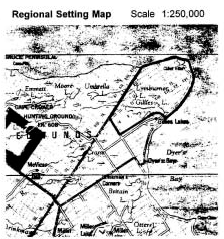
Cabot Head Provincial Nature Reserve is located on the Bruce Peninsula on Georgian Bay approximately 10 kilometres north of the community of Dyer’s Bay and about 25 kilometres east of the town of Tobermory. A total of 4,514 hectares (11,154 acres) of land have been acquired and regulated under the Provincial Parks Act in both the Townships of Lindsay and St. Edmunds, in Bruce County. The regulated park lands in St. Edmunds Township are managed under an agreement with the Canadian Parks Service as part of Bruce Peninsula National Park. Subject to the status of a native land claim (see Section IX), the intent is that these lands will eventually be deregulated and title transferred to the federal government. The 632 hectares (1,562 acres) of regulated park lands (see Figure 1) and additional acquired Crown lands (see Figure 2) within Lindsay Township are managed by Ontario Parks, Ministry of Natural Resources (MNR), and are the focus of this interim management statement.
A cottage on Wingfield Basin (Part of Lot 14, Concession 17, East of Bury Road (EBR), Lindsay Township, is leased out by the Ministry of Natural Resources.
Part of Lots 47 and 48, Concession 17, EBR, are federally owned lands located within the proposed Provincial Nature Reserve boundary (see Figure 2). The Coast Guard leases the 100-year-old Cabot Head lighthouse and light-keeper’s cottage to Lindsay Township which in turn leases the site to the Friends of Cabot Head for the purpose of a museum and environmental resource centre.
Cabot Head is a part of the Niagara Escarpment Parks and Open Space System and is presently classified as a Nature Reserve in the Niagara Escarpment Plan (see Figure 2 for plan boundary). The applicable land use designations are: Escarpment Natural Area, Escarpment Protection Area, and Escarpment Rural Area.
Guidelines:
The cottage lease will be reviewed prior to renewal and during preparation of a Park Management Plan.
Ontario Parks, Ministry of Natural Resources, will continue to manage the acquired and regulated provincial lands in Lindsay Township.
Under a federal-provincial agreement, the Canadian Parks Service will continue interim management of the St. Edmunds Township portion of the Provincial Nature Reserve until such time as the lands are formally deregulated and transferred to the federal government.
Area of Natural and Scientific Interest
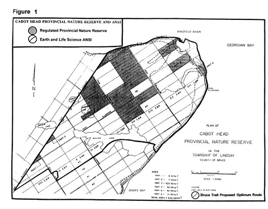
Enlarge this map of Cabot Head Provincial nature reserve (PDF)
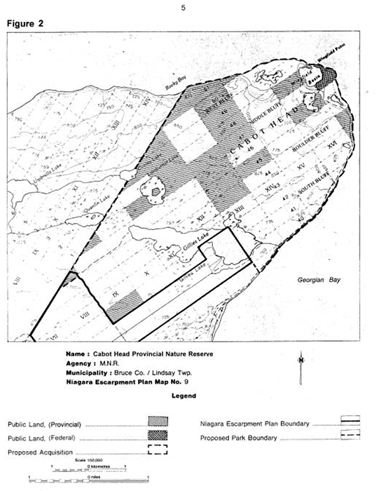
Figure 2: A map of the Cabot Head provincial nature reserve.
Enlarge this map of the Cabot Head provincial nature reserve (PDF)
II. Land acquisition and disposition
Several properties in Lindsay Township have been, or are in the process of being acquired by the province (see Figure 2).
Land acquisition in St. Edmunds Township falls within the Canadian Parks Service’s mandate as addressed in Bruce Peninsula National Park Interim Management Guidelines and, upon approval, the Bruce Peninsula National Park Management Plan.
Guidelines:
Land acquisition by the province will proceed in Lindsay Township to consolidate provincial holdings, to facilitate management and protect significant features. Lands will be acquired on a willing seller - willing buyer basis as opportunities arise, subject to the availability of funding. Municipal road allowances may also be acquired subject to Native land claims.
Acquired Crown lands, through time, may be regulated under the Provincial Parks Act subject to the status of native land claims (see Section IX). Land acquisition by the province will not occur in St. Edmunds Township.
The St. Edmunds Township portion of the Provincial Nature Reserve, which is currently managed by Parks Canada, will be deregulated and transferred to the federal government once the local First Nations’ unsatisfied interests are resolved (see section IX).
III. Existing and proposed development
Existing development in the Nature Reserve consists of a cottage on Wingfield Basin. Parking and washroom facilities are located adjacent to the federally owned lighthouse and light-keeper’s cottage. These facilities are maintained by the Friends of Cabot Head. The proposed optimum route for the Bruce Trail (see Figure 1) will eventually be established in the Cabot Head Provincial Nature Reserve in cooperation with the Bruce Trail Association and the Peninsula Bruce Trail Club.
Guidelines:
The proposed optimum route for the Bruce Trail and related facilities may eventually be established through the Nature Reserve following preparation of a Trails Implementation Plan. The Peninsula Bruce Trail Club would be responsible for maintaining the trail.
Once the optimum Bruce Trail route is established, interpretive stations may be installed along the Bruce Trail or at other suitable locations.
Appropriate signs, fences, gates and barriers may be installed as required to control access onto acquired Crown lands and the regulated Provincial Nature Reserve.
All proposed development in the Provincial Nature Reserve will be contingent upon approved plans, funding, partnerships, etc.
IV. Recreation activities
Hiking, cross-country skiing, snowshoeing, picnicking, sport fishing, canoeing, boating, scuba/skin diving and natural heritage appreciation are informal recreational activities permitted in the Nature Reserve.
Rock climbing is considered a non-conforming activity in a Nature Reserve, however, several climbing sites are located in areas of proposed acquisition.
Guidelines:
Hunting, rock climbing, mountain biking, and off-road/all-terrain vehicles will not be permitted in the regulated Provincial Nature Reserve. These uses will be discouraged on acquired Crown lands.
Until such time as a Park Management Plan is prepared, informal snowmobiling on existing trails will be treated as an existing, nonconforming activity, provided park natural values are not placed at risk. No new trails will be approved in the Nature Reserve or on acquired Crown lands.
Non-permitted activities will be discouraged through public education, signs, and ultimately enforcement if necessary.
A Trail Implementation Plan will be prepared prior to establishment of the optimum Bruce Trail route (see Figure 1) and related facilities. With the cooperation of the Friends of Cabot Head and the federal government, a Bruce Trail Overnight Rest Area might eventually be considered in the vicinity of the Cabot Head lighthouse.
Recreation programs will not be promoted.
V. Commercial activities
Guideline:
No commercial forest management operations, fishing, bait fishing or trapping will be permitted in the Nature Reserve.
VI. Natural resources
Cabot Head is contained within the Upper Bruce Peninsula Ecosystem and is part of the largest Area of Natural and Scientific Interest (ANSI) on the Niagara Escarpment.
Life Science - The Cabot Head (Lindsay Township Portion) supports 158 vegetation community types sustaining 514 vascular plant species, including 10 nationally and provincially rare, 40 regionally rare and 16 locally significant flora (e.g., Lakeside Daisy, Dodge’s Hawthorn, Wall-rue). A large number of northern or circumboreal species are also present (e.g., Twinflower, Rocky Mountain Fescue) and several Western disjuncts are present (e.g., Male Fern, Holly Fern). Cabot Head also harbours noteworthy alvar species (e.g., False Pennyroyal, Prairie Dropseed, Lakeside Daisy) and numerous Great Lakes shoreline species including Great Lakes endemics (e.g., Houghton’s Goldenrod, Sand Cherry). The area is also rich in fen species (e.g., Bog-Rosemary, White Beak-rush). Old growth Eastern White Cedar forests also occur in the area.
Of bird species, 126 have been recorded during breeding season, including the nationally and provincially endangered Kirtland’s Warbler, the nationally and provincially vulnerable Eastern Bluebird and Caspian Tern, the provincially threatened Black Tern, the provincially vulnerable Black-crowned Night-Heron, and 19 regionally rare species. Eleven mammals and 21 amphibian and reptile species have been noted, including the nationally and provincially threatened Eastern Massasauga Rattlesnake (Jalava, Varga, Riley, 1995).
Earth Science - Cabot Head Provincial Nature Reserve is located within a provincially significant earth science Area of Natural and Scientific Interest. Earth science features include: Manitoulin Formation platform; sculpted bedrock features related to catastrophic subglacial sheetflood events; postglacial karst surfaces; abandoned and raised ancestral islands (and related shore features) of glacial Lake Algonquin; modern and ancient spit and bar development at Wingfield Basin. The features listed above are provincially or nationally significant (raised glacial Lake Algonquin shore features; karst) (Kor, 1994).
Guidelines:
A detailed life science report may be completed prior to preparation of a Park Management Plan.
Due to the very high significance and fragility of the geological features at Cabot Head, the ANSI lands in Lindsay Township should be secured as an addition to the Provincial Nature Reserve. This would include the low areas of Wingfield Basin and the overlooking promontories of West, Middle Boulder and South Bluffs (see Figure 2).
Visitor use of the site should remain at low levels to ensure the protection of its high-quality and sensitive shorelines, alvars and escarpment rims and cliffs.
Once acquired, improved access to fragile shore stacks on Boulder Bluff and South Bluff should not be provided, and rock climbing activities and scientific sampling of these sites should be prohibited.
VII. Cultural resources
- Pre-history - Archaeological evidence dates the earliest human occupation of Cabot Head to the arrival of the Amerindians nearly 2,500 years ago. The Bruce Peninsula was originally settled by the Odawa of Algonquin background.
- History - In 1616, Samuel de Champlain visited the Bruce Peninsula. Logging and fishing became the predominant activities in the late 1800’s. Local sites of historical interest include the remains of the Lymburner Sawmill by Gillies Lake, a fishing station, the wreck of the steam tug “Gertie C.” in Wingfield Basin, and the Cabot Head Light Station. The Wingfield Basin is significant because it is the only natural harbour along the Georgian Bay shoreline north of Lion’s Head. A number of ships have been lost in Georgian Bay off Cabot Head.
Guideline:
Both an archaeological and historical survey is needed to further document the cultural values of the local area. These surveys should be completed prior to preparation of a Park Management Plan.
VIII. Natural heritage education
There are no natural heritage education facilities present in the Nature Reserve. However, the Friends of Cabot Head have established a museum and environmental resource centre in the 100-year-old Cabot Head Lighthouse.
Fact sheets providing basic information about the Provincial Nature Reserve and Cabot Head Earth Science Area of Natural and Scientific Interest are available to the public upon request.
Guidelines:
The fact sheets will be updated and reproduced as required.
Interpretive stations may be established along the proposed Bruce Trail or at other suitable locations.
Interpretive panels may be installed at the Cabot Head Museum in partnership with the Friends of Cabot Head.
IX. Native interests
Guideline:
Subject to the status of local Native land claim negotiations and/or government policy, the status of provincially owned land will not be changed.
X. Marketing
Guideline:
A marketing plan will not be required. This provincial park will not be promoted aside from general information provided in the fact sheet and as identified in information presented to the public regarding the Niagara Escarpment Parks and Open Space System and, in the course of time, the Bruce Trail Reference.
XI. Research
Guidelines:
Pre-approved research or inventory projects will be encouraged, particularly in subject areas required to assist in preparation of a Park Management Plan and to assist in identifying and protecting sensitive natural features or cultural resources in the local area.
XII. References
Blachut, S. Umbrella Lake Special Area Earth Science Inventory Checklist. Ontario Ministry of Natural Resources, Division of Parks, Parks Planning Branch, 1977.
Bracken, M., Barnes, J., and Oates, C. The Escarpment - A Climber’s Guide. Borealis Press, Toronto, 1991.
Bruce Trail Association. Bruce Trail Reference, 19th Edition. Hamilton, 1994.
Canadian Parks Service. Bruce Peninsula National Park Interim Management Guidelines. Environment Canada, 1988.
Canadian Parks Service. Bruce Peninsula National Park Management Plan (draft). Canadian Heritage, 1995.
Cowell, D.W., and Woerns, N. Earth Science Candidate Nature Reserves in the Niagara Escarpment Planning Area. Ontario Ministry of Natural Resources, Division of Parks, 1976.
Cuddy, D.G. Cabot Head Life Science Inventory Checklist. Ontario Ministry of Natural Resources, Division of Parks, Parks Planning Branch, 1976.
Cuddy, D.C., Lindsay, K.M., and Macdonald, l.D. Significant Natural Areas Along the Niagara Escarpment. Ontario Ministry of Natural Resources, Parks Planning Branch, 1976.
Hamalainen, P., Pelshea, V., Spittal, D., Greenland, G., and Kovacevic, D. The Niagara Escarpment Archaeological Survey. 1973
Jalava, J.V., Varga, S., and Riley, J.L. Ecological Survey of the Niagara Escarpment Biosphere Reserve (Preliminary). Ontario Heritage Foundation and Ontario Ministry of Natural Resources, 1995.
Kor, P. An Earth Science Inventory and Evaluation of the Cabot Head Provincial Nature Reserve and Area of Natural and Scientific Interest Lindsay Township Portion. Ontario Ministry of Natural Resources, Southern Region, Aurora, 1994.
Niagara Escarpment Commission. Niagara Escarpment Plan. Ontario Ministry of Environment and Energy, Toronto, 1994.
Ontario Ministry of Natural Resources. Cabot Head Provincial Nature Reserve Fact Sheet (Unpublished) Owen Sound District Office, 1984.
Ontario Ministry of Natural Resources. Ontario Provincial Parks Management Planning Manual. Provincial Operations Branch, Peterborough, 1994.
Ontario Ministry of Natural Resources. Ontario Provincial Parks: Planning and Management Policies, 1992 Update. Provincial Parks and Natural Heritage Policy Branch, Toronto, 1992.
Ontario Ministry of Natural Resources. Owen Sound District Land Use Guidelines. Owen Sound District, Owen Sound, 1983.
S.L. Ross Environmental Research Limited, Mosquin Bio-lnformation Ltd., and Horler Information Inc. Bruce Peninsula National Park Biophysical Survey. Canadian Parks Service, 1990.
Varga, S. Cabot Head Life Science Inventory Checklist. Ontario Ministry of Natural Resources, 1995.