Clear Creek Forest Provincial Park Management Statement
This document provides direction on the management of Clear Creek Forest Provincial Park.
Approval statement
This Interim Management Statement (IMS) provides direction for the custodial management of the Clear Creek Forest until such time as a Park Management Plan may be prepared.
An Interim Management Statement, by design, is primarily an internal document intended to provide short- term guidance for Ontario Parks’ managers and staff. The Interim Management Statement will govern all activities occurring within Clear Creek Forest and focuses on custodial management required to protect the property’s values and ensure public health and safety.
This Statement, along with the results of a number of additional studies, will provide a basis for the preparation of the Park Management Plan.
I am pleased to approve the Clear Creek Forest Interim Management Statement.
Yours truly,
Peter Sturdy, Zone Manager
Southwestern Zone, Ontario Parks
Date: September 10, 2002
1.0 Introduction
As part of the Ontario Parks Legacy 2000 partnership, Ontario Parks and The Nature Conservancy of Canada (NCC) worked together to secure significant natural areas for new provincial nature reserves. Clear Creek Forest is one of several properties being protected under this partnership through considerable local community-based effort.
To achieve the goal of acquiring and securing new areas, Ontario Parks Legacy 2000 developed new innovative arrangements for area protection and management. In this particular case, the NCC and the Province of Ontario (as represented by the Minister of Natural Resources) retain title to separate parcels of land that constitute Clear Creek Forest, while Ontario Parks regulates and protects the area as a Provincial Nature Reserve under a long-term lease agreement. The lease agreement was formally endorsed in 2001.
Clear Creek Forest will be classified as a Provincial Nature Reserve once regulated under the Provincial Parks Act in recognition of its ability to represent the distinctive natural habitats and landforms of the Carolinian Life Zone.
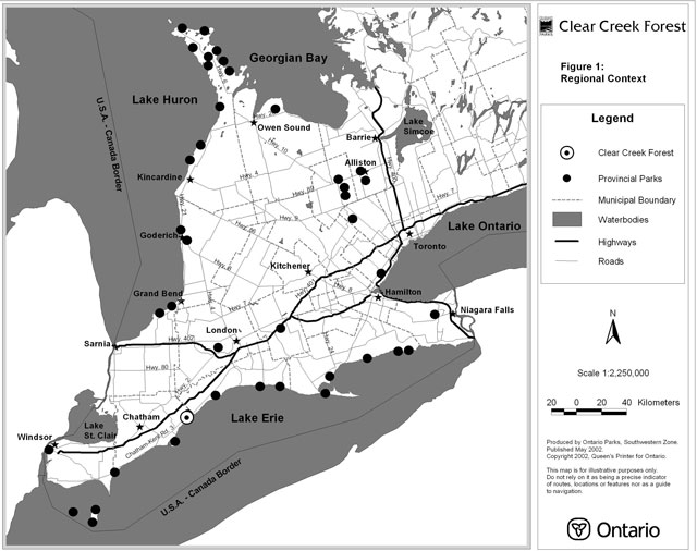
The 324 hectare (800 acre) property known as Clear Creek Forest is located in the Municipality of Chatham-Kent, crossing Talbot Trail (Chatham-Kent Road 3, formerly Talbot Road) at Clearville, approximately four kilometres west of the Elgin County municipal boundary (see Figure 1).
The history of the area includes evidence of native inhabitants. In 1939, a preliminary archaeological survey highlighted that the area of Clearville experienced three separate native occupations, all Late Woodland, prior to European settlement. In 1993, an archaeological site was accidentally discovered in an area now within the boundary of Clear Creek Forest. Dating of the artifacts indicates a period of occupation dating 900-1500 AD. The site was likely chosen for its close access to water, and its high location, which was easily defensible.
Colonel Talbot is considered to be the person who colonized the area with European settlers. The naming of Talbot Trail, which bisects the property, signifies this.
The gravesites of the Bury family, the founders of the hamlet of Clearville, are situated within a cemetery located on the property. The Gosnell family is also historically important as they are credited with influencing the development of the area.
Up until 1965, approximately 80 hectares of upland forest, comprising the northern portion of Clear Creek Forest, was conservatively harvested for timber. Concurrent use of the forest, terminating around the same time as logging, included the grazing of cattle. Historical land use has also included field cropping. Up until 2001, approximately 28 hectares (69 acres) of the site were utilized for the growing of crops.
Adjacent land uses include agriculture, rural residential, cemetery, aggregate extraction, Scouts Canada Camp Cataraqui and Clearview Park municipal campground.
Clear Creek Forest lies within ecological site district 7E-1 and the Carolinian Life Zone, a zone representing the extreme southwest region of Ontario where the eastern deciduous forest of North America has its most northern limits. It is within this zone that the highest frequencies of rare and endangered floral and faunal species in Canada are found. Clear Creek Forest is comprised of primary hardwood forest communities, secondary upland forests, hawthorn savanna and cropped fields. The site is the largest woodland in the provincially significant Kent-Elgin Shoreline Life Science Area of Natural and Scientific Interest (ANSI).
The ANSI contains examples of 18 taxa considered to be of Carolinian affinity. This closed-canopy deciduous forest contains typical species such as red oak (Quercus rubra), sugar maple (Acer saccharum), and American beech (Fagus grandifolia) as well as Shumard oak (Quercus shumardii), a tree designated as being of special concern by the national Committee on the Status of Endangered Wildlife in Canada (COSEWIC). Twenty-four rare vascular plants have been recorded, including the tall ironweed (Vernonia missurica), which is a species of the midwestern prairies.
There are also noteworthy examples of fauna found in Clear Creek Forest. Ten mammals have been recorded and include the Southern flying squirrel (Glaucomys volans), designated to be of special concern by COSEWIC. The provincially rare giant swallowtail (Papilio cresphontes), along with 15 other butterfly species, has been documented. Ten herptiles have also been recorded.
Figure 1: Regional context
Enlarge Figure 1: Regional context (PDF)
Approximately seventy bird species have been noted, including the vulnerable red-headed woodpecker (Melanerpes erythrocephalus), and loggerhead shrike (Lanius ludovicianus). Over 20 bird species of concern, as identified by the Municipality of Chatham-Kent, have been recorded at the site. Clear Creek Forest has been designated as an internationally Important Bird Area (IBA), by BirdLife International and its partners, due to the endangered species habitat it provides.
From an earth science perspective, Clear Creek Forest is located on a portion of the St. Clair clay flats plain. A glacio-fluvial channel has left behind deposits of sand and gravel on the property. The soil composition of the site is primarily silty to silty-clay till interspersed with pebbles and stones. The northeast section of the site consists of sand that has been reworked by wind action. The sandy composition of this area contributes to improved drainage compared with other portions of the property.
The topography of the nature reserve slightly undulates with the exception of dramatic elevation changes, approximately 22 metres of relief, in the area of the ravine. The highest elevations occur in the northwest section of the property with the lowest sections occurring in the southeast area.
The significant life, earth and cultural resources of Clear Creek Forest make a significant contribution to the Ontario Provincial Parks system. The protection of the site’s significant natural and archaeological features is a high priority.
Use by motorized all-terrain vehicles (ATVs) and horseback riding has resulted in erosion and vegetation trampling. This, in turn, has contributed to invasive vegetation species becoming established, including garlic mustard (Alliaria petiolata). Control of these species is necessary.
This Interim Management Statement identifies custodial management strategies necessary to protect provincially significant natural and cultural heritage values, until such time as a park management plan can be undertaken.
2.0 Interim management guidelines
Unless otherwise noted, the management policies for Nature Reserve class parks, as presented in Ontario Provincial Parks: Planning and Management Policies will apply to this site. The management of Clear Creek Forest will be incorporated into the operations plan for Rondeau Provincial Park.
2.1 Natural resources stewardship
Native insects and diseases affecting vegetation will be allowed to progress naturally, except where they threaten significant natural heritage values of the site, in which case they will be controlled where feasible. Non-native insects and diseases will be controlled where feasible. Where control is deemed necessary, it will be directed as narrowly as possible to the specific insect or disease so as to have minimal effects on the rest of Clear Creek Forest. Biological controls will be used whenever possible.
Fires in the nature reserve will be suppressed. Suppression techniques that have the least residual impact on the site will be used wherever practical.
Flora - general
- control of faunal populations may be necessary to allow for the full range of regeneration.
- invasive floral species may be controlled using herbicides followed by replacement with competitive native species.
- planning for herbaceous flower and understory shrub introductions, as the canopy closes, should be considered.
Primary hardwood forest communities
- if it is determined that plant diversity has decreased, wildflowers may be planted to establish new stands.
- restricting ATVs and horseback riding access to the site may control the spread of invasive species (e.g., garlic mustard).
- disturbances may be mitigated by establishing new stands of rare wildflower species (e.g., broad beech fern, lizard’s tail, appendaged waterleaf), on a site-specific basis, in the absence of natural recovery.
Secondary forests
- To promote structured forest, a diverse range of tree species, propagated from seed collected in the primary and secondary forests, may be planted in open fields.
Cropped fields
- tree seeding immediately after the last agricultural crop harvest will occur.
- if tree seeding is not possible, a clover cover crop should be planted to minimize colonization by weed species.
- small seeded tree species (e.g., tulip tree, sassafras, flowering dogwood, basswood) may be planted in the spring.
Flora - species specific
Species recovery work proposed at Clear Creek Forest will involve the participation of associated recovery teams/working groups.
American chestnut
- if historically present, this species may be introduced to Clear Creek Forest as the site provides suitable habitat.
Broad beech fern
- disturbance of habitat by ATV traffic needs to be curtailed.
- plantings in impacted, previously occurring, sections of the nature reserve may occur to promote spore dispersal.
Fauna - species specific
Red-headed woodpecker
- forest edge/meadow should be preserved as habitat.
2.2 Cultural resources
- significant cultural features will be protected.
- the cemetery and associated access route will not be included in the regulated park area.
- It is recommended that a detailed cultural resources inventory be undertaken of the nature reserve.
2.3 Recreational activities
- only low intensity day-use activities (e.g., hiking, snowshoeing, etc.) and facilities (e.g., trails, interpretive panels, etc.), which conform to Ontario Parks’ Provincial Nature Reserve policy and enhance the appreciation of Clear Creek Forest, will be encouraged.
- ATV use, horseback riding, hunting and trapping are considered to be incompatible uses of Clear Creek Forest. Appropriate measures will be taken to exclude these activities (signage, fencing, gating, public education, enforcement, etc.).
2.4 Commercial activities
- commercial activities including timber harvesting and agricultural field production will not be permitted.
2.5 Land tenure
An area of 231 hectares (572 acres) described as part of lots 59, 60 and 61, North of Talbot Road (NTR), and part of lot 59, South of Talbot Road (STR), in the Municipality of Chatham-Kent (geographic Township of Orford), was first secured by the NCC in November 2000. Through a significant capital contribution to the NCC, Environment Canada made this initial land acquisition possible. The cemetery grounds and associated access lane (0.23 hectares/0.58 acres) south of Talbot Trail will be excluded from the nature reserve.
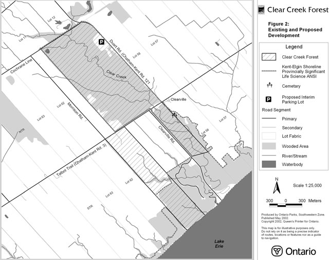
In October 2001, the Province of Ontario expanded the Clear Creek Forest site with the securement of a 92 hectare (227 acre) parcel described as Lot 61, STR (see Figure 2). Fifty hectares (125 acres) of this parcel are currently under agricultural lease. Approximately 10 hectares (25 acres) of this parcel are being restored per annum by the NCC. The agricultural lease will expire following the 2004 harvest.
A 99-year lease agreement for the long-term management of Clear Creek Forest was signed between The NCC and the Province (Ontario Parks, Ministry of Natural Resources) in 2001.
Subject to the availability of funding, additional adjacent lands may be secured to expand the nature reserve.
As part of a park management process, Ontario Parks will consider consolidating title of Clear Creek Forest to the Province.
Figure 2: Existing and proposed development
Enlarge Figure 2: Existing and proposed development (PDF)
2.6 Existing and proposed development
Existing
- development consists of fencing, gates and signs identifying the park.
- a small informal trail system exists on the originally acquired parcel (part of lots 59, 60 and 61, NTR).
Proposed
- gates, fences, barriers and signs may be placed on the property to prevent unauthorized vehicles from entering the property.
- the development of a small interim parking lot located adjacent to Duart Road (Chatham-Kent Road 121) is recommended to allow access to the property. The location of a permanent parking lot will be determined in a future park management planning process.
- a self-guided interpretive trail may be constructed. Interpretive panels may also be installed along the trail to highlight unique or significant features.
2.7 Aboriginal interests
- there are no known land claims or special treaty rights that have a bearing on park management.
- local First Nations will be consulted during the park management planning process.
2.8 Client services
- information on the site’s resources, their significance and the need for co-operative stewardship to preserve them will be provided by Ontario Parks.
- additional information will be provided on the Ontario Parks and NCC websites.
2.9 Research
- a biological inventory was initiated in 2001 with the final report to be submitted in 2002.
- all research will be conducted, or authorized, by Ontario Parks. Research projects will be subject to Ontario Parks policy PM 2.45, “Research Activities in Provincial Parks”.
2.10 Marketing
The use of the park will be consistent with the nature reserve classification; consequently, interpretive uses with minimal impact on the property will be allowed. Information on the park’s resources, their significance and need for protection and its linkage with other parks and protected areas will be provided through printed media (e.g., brochures, fact sheets) at Rondeau Provincial Park and on the Ontario Parks website.
3.0 Sources/references
Bird Studies Canada. IBA Listing - Clear Creek, ON. January 9, 2002. http://www.bsceoc.org/iba/site.cfm?siteID=ON033&lang=en [inactive link]
Bowles, J., Klinkenberg, R., Kanter, M., Woodliffe, A. Significant Natural Areas of Kent County, Ontario 1985-1986 (Draft). Carolinian Canada Project. 1994.
Buck, Graham. Clear Creek Restoration Ideas. Unpublished report. The Nature Conservancy of Canada, 2001.
Carolinian Canada. Brief Description of the Big Picture. January 9, 2002. http://www.carolinian.org/Big%20Picture.htm [inactive link]
Jury, W. Clearville Prehistoric Village Site in Orford Township: Kent County, Ontario. Bulletin of Museums, No. 2, 1941.
Nature Conservancy of Canada. Nature Conservancy of Canada. July 15, 2002. http://www.natureconservancy.ca/files/index.asp [inactive link]
Ontario Ministry of Natural Resources. Chatham District Land Use Guidelines. Chatham District, 1983.
Ontario Ministry of Natural Resources. Ontario Parks. July 15, 2002.
Ontario Ministry of Natural Resources. Ontario Provincial Parks Planning and Management Policies. Toronto: Parks and Natural Heritage Policy Branch, 1992.
Ontario Ministry of Natural Resources. Park Policy, Procedure and Bulletin PM 11.02.01, "Preparation of Interim Management Statements", Provincial Park Operations Branch, 1994.