Cognashene Lake and Cognashene Point Conservation Reserves Management Statement
This document provides policy direction for the protection, development and management of Cognashene Lake and Cognashene Point Conservation Reserves and their resources.
Statement of Conservation Interest
Ministry of Natural Resources
Parry Sound District
Prepared with the assistance of:
Meteek & Company
Huntsville, Ontario
March 2004
Approval Statement
We are pleased to approve this Statement of Conservation Interest for Cognashene Lake Conservation Reserve (C35) and Cognashene Point Conservation Reserve (C40).
Cognashene Lake Conservation Reserve (C35) is a large area of Crown land, covering 2,945 hectares in Gibson Ward of the Area Municipality of the Township of Georgian Bay in the District Municipality of Muskoka. The site includes a small portion of the Georgian Bay shoreline, and extends east to Go Home Lake. It is located about 15 kilometres southwest of MacTier.
The south-western part of this conservation reserve contains an extensive lowland and wetland complex, with important fish spawning and waterfowl staging habitat, as well as large wild rice stands and a rich variety of floating and submerged aquatic plants, with several rare plant and animal species. Most of the wetland complexes in this conservation reserve have been identified as having the potential of being provincially significant wetlands, through the use of satellite imagery and other available wetland information. In particular, those in the central portion of this site show a very high potential to be provincially significant wetlands.
Cognashene Point Conservation Reserve (C40) is a small, 42 hectare area of Crown land also in Gibson Ward of the Area Municipality of the Township of Georgian Bay in the District Municipality of Muskoka. It lies immediately west of Cognashene Lake Conservation Reserve and abuts the southeast shore of Cognashene Lake. This site provides representation of several combinations of vegetation and landforms, including birch and poplar stands on rock barrens.
Cognashene Lake Conservation Reserve and Cognashene Point Conservation Reserve are two of 378 new protected areas approved through Ontario’s Living Legacy Land Use Strategy, aimed, in part, at completing Ontario’s system of parks and protected areas. They are part of the Great Lakes Heritage Coast, a signature site identified through Ontario’s Living Legacy Land Use Strategy. The Great Lakes Heritage Coast is designed to protect the coastal environment and provide for recreational and tourism opportunities associated with the natural environment.
During the "Lands for Life" planning process, the public was widely consulted and provided valuable input into what became Ontario’s Living Legacy Land Use Strategy. Comments received at that time and during consultation related to the formal Public Lands Act regulation of the boundaries of these conservation reserves were generally supportive of the protection of these areas. Stakeholders who provided comment during the earlier consultation for this site were subsequently consulted regarding the draft Statement of Conservation Interest and their comments were considered in the finalization of this document.
This Statement of Conservation Interest provides guidance for the management of these conservation reserves and provides the basis for the ongoing monitoring of activities. More detailed direction is not anticipated at this time. Should more complex resource management or conservation issues arise or significant facility development be considered, then a detailed Resource Management Plan will be prepared with full public consultation.
Cognashene Lake Conservation Reserve and Cognashene Point Conservation Reserve are managed under the direction of the District Manager and the Parry Sound Area Supervisor of the Ministry of Natural Resources, Parry Sound District.
Approved by:
R. Griffiths
District Manager
Parry Sound District
Approved by:
Ron Running
Regional Director
Southern Region
1.0 Introduction
Ontario’s Living Legacy, the result of an extensive planning process that began in early 1997, culminated in the approval in July 1999 of a Land Use Strategy that identifies the intended strategic direction for Crown land, including the completion of Ontario’s system of parks and protected areas. This process, which included extensive public consultation, resulted in the recommendation for regulation of 378 new protected areas, including Cognashene Lake Conservation Reserve (C35) and Cognashene Point Conservation Reserve (C40).
Cognashene Lake Conservation Reserve is a 2,945 hectare area of Crown land, located in Gibson Ward in the Area Municipality of the Township of Georgian Bay, in the District Municipality of Muskoka. It is located about 15 kilometres southwest of the hamlet of MacTier. It abuts Cognashene Point Conservation Reserve (C40) on its southwestern boundary. Both of these conservation reserves are part of the Great Lakes Heritage Coast identified through Ontario’s Living Legacy Land Use Strategy. The Great Lakes Heritage Coast is designed to protect the coastal environment and provide for recreational and tourism opportunities associated with the natural environment.
Many of the lands adjacent to this site are privately owned; these are not part of the conservation reserve and will remain privately owned. There are a large number of adjacent cottage lots, particularly on Go Home Lake, Go Home Bay, Freddy Channel, Cognashene Lake and Georgian Bay.
The municipal road allowances and shore road allowances that cross through or are adjacent to this conservation reserve remain in the jurisdiction of the municipality, and are not a part of this site.
Cognashene Lake Conservation Reserve is surrounded by waterbodies including Go Home Lake, Go Home Bay, Cognashene Lake and Georgian Bay and as a result, access to the site is by boat or by snowmobile in winter.
Cognashene Lake Conservation Reserve protects the natural corridor connecting Cognashene Lake to Go Home Lake. Included within the site are numerous extensive wetland complexes supporting a variety of meadow marsh, fen and bog types, both interior and Georgian Bay shoreline and upland forest, rock barren and thicket swamp communities. It includes extensive representation of various provincially and globally rare community types, most significantly, Virginia chain fern bogs, winterberry thicket swamps and leatherleaf – forb shrub fens.
The wetlands of Cognashene Lake Conservation Reserve have been evaluated using satellite imagery and various sources of existing broad scale wetland mapping, and have been identified as having high potential to be provincially significant wetlands. A large area of wetlands in the central area of Cognashene Lake Conservation Reserve was identified as having particularly high potential (Ducks Unlimited Canada and OMNR, 2003). The Cognashene Lake and Longuissa Bay areas have been previously identified as Muskoka Heritage Areas by the District Municipality of Muskoka, based on life science values (Reid & Bergsma 1994).
Cognashene Point Conservation Reserve is a small area, 42 hectares, to the west of the west boundary of Cognashene Lake Conservation Reserve, and adjacent to the southwest shore of Cognashene Lake. It is mostly surrounded by private lands which are not a part of the conservation reserve. It also excludes the small portion of municipal shore road allowance which borders Cognashene Lake.
Cognashene Point Conservation Reserve provides protection for both a large wetland complex and a continuation of protection of a larger forest-rock barren mosaic community that is found throughout the adjacent Cognashene Lake Conservation Reserve.
Conservation reserves are established under the authority of the Public Lands Act, Ontario Regulation 805/94. Cognashene Lake Conservation Reserve was established by Ontario Regulation 148/02 on May8, 2002. Cognashene Point Conservation Reserve was established by Ontario Regulation 86/01 on April6, 2001.
A Statement of Conservation Interest (SCI) is prepared under the direction of Procedural Guideline A – Resource Management Planning (PL. Procedure 3.03.05). The purpose of this SCI is to identify and describe the values of Cognashene Lake Conservation Reserve and Cognashene Point Conservation Reserve. The SCI also outlines the activities that currently occur within the conservation reserves and provides guidelines for the management of current and future activities in the context of protecting the natural, recreational and cultural values.
1.1 Background Information:
| Name | Cognashene Lake Conservation Reserve (C35) |
|---|---|
| Site Region/District | Georgian Bay 5E -7 |
| OMNR Administrative Region/District/Area | Southern Region/Parry Sound District/Parry Sound Area |
| Total Area (ha) | 2,945 hectares |
| Regulation Date | May 8, 2002 (O. Reg. 148/02) |
| First Nations | Robinson-Huron Treaty and Williams Treaty |
| OBM map sheets | 10 17 5800 49750, 5800 49800, 5850 49750, 5850 49800, 5850 49850, 5900 49800 |
| Topographic Map | Penetanguishene 31D/13; Lake Joseph 31E/14 |
| UTM co-ordinates | 17T 58780 498200 (Centroid) |
| Name | Cognashene Point Conservation Reserve (C40) |
|---|---|
| Site Region/District | Georgian Bay 5E -7 |
| OMNR Administrative Region/District/Area | Southern Region/Parry Sound District/ Parry Sound Area |
| Total Area (ha) | 42 hectares |
| Regulation Date | April 6, 2001 (O. Reg. 86/01) |
| First Nations | Robinson-Huron Treaty and Williams Treaty |
| OBM map sheets | 10 17 5850 49750 |
| Topographic Map | Penetanguishene 31D/13 |
| UTM co-ordinates | 17T 58610 49770 (Centroid) |
1.2 Representation:
Earth Science Representation:
Bedrock - Go Home complex, a younger granitic unit underlies both conservation reserves, which fall in the Go Home Domain, Algonquin Terrane of the Central Gneiss Belt of the Proterozoic Grenville Province.
Surficial - Cognashene Lake Conservation Reserve is an area of bare bedrock plain with pockets of organic deposits, some quite large. The smaller Cognashene Point Conservation Reserve is similar, although the bedrock is overlain by areas of very thin drift.
Life Science Representation:
Cognashene Lake Conservation Reserve protects the natural corridor connecting Cognashene Lake to Go Home Lake. Included within the site are numerous extensive wetland complexes supporting a variety of meadow marsh, fen and bog types, both interior and Georgian Bay shoreline and upland forest, rock barren and thicket swamp communities.
Cognashene Point Conservation Reserve protects a small parcel of land connecting Cognashene Lake Conservation Reserve to Cognashene Point. The site protects a large mosaic wetland community of leatherleaf bog and open lily pond that stretches from a sheltered bay off of Cognashene Lake to a bay off of Freddy Channel. In addition, the site includes the continuation of the dominant community type throughout the Cognashene Lake area.
Cultural Resources Representation:
Neither detailed cultural research nor inventory has been carried out for these conservation reserves. Recent regional evaluation (OMNR 2003) shows that these conservation reserves contain areas that have a high potential for cultural heritage sites.
Recreational Opportunities:
Both of these sites touch on shoreline that is accessible from Georgian Bay. The scenic beauty of the Georgian Bay coastline will continue to attract people to the area, which is only accessible by boat and by snowmobile in the winter. Boating, canoeing and fishing in the adjacent waters can contribute to shoreline use for mooring, picnicking and camping. The area is also used for hunting, and there is some recreational use by nearby land owners for hiking, viewing and nature-related activities.
1.3 Survey Work:
| Survey Level | Earth Science | Life Science | Cultural | Recreational | Other |
|---|---|---|---|---|---|
| Reconnaissance | Blackburn, 2003a,b | Cooper, 2001a,b | OMNR,2003 | Brown, 2003a,b | None |
| Detailed | None | None | None | None | None |
| Requirement | None | Monitor the status/presence of significant species and associations. | Research to be encouraged. | Monitor use impacts | None |
2.0 Values to be protected
These conservation reserves are located entirely within Hills’ (1959) ecological Site District 5E -7. Values include earth science, life science and recreational/aesthetic values, with an emphasis on the life sciences.
2.1 Earth Science:
Bedrock:
(Earth science information, unless otherwise noted, is taken from Blackburn, 2003a, b))
Cognashene Lake Conservation Reserve and Cognashene Point Conservation Reserve both lie within the Go Home Domain, Algonquin Terrane in the western part of the Central Gneiss Belt of the Proterozoic Grenville Province.
The Go Home Domain consists of highly deformed 1.8 to 1.6 billion-year-old gneisses and migmatites of supracrustal and igneous origin that have been intruded by younger, 1.5 to 1.4 billion-year-old granitic and monzonitic plutons. It has been divided into two gneiss associations, the Honey Harbour gneiss association and the Pine Island Migmatites. (Culshaw et al, 1991, Easton, 1992a) The Honey Harbour gneiss association is intruded by younger granitic plutons collectively named the Go Home complex. Both conservation reserves are underlain only by rocks of the Go Home complex.
The Grenville Province is the product of thrusting and imbrication of the crust to the northwest as it collided with a continental landmass to the southeast. The Grenville Orogeny, circa 1140 to 1070 million years ago, culminated more than 500 million years of crustal evolution. The eroded roots of the products of these events are displayed in the complexly metamorphosed and deformed rocks of the region (Easton, 1992b).
The Algonquin Terrane is one of four lithotectonic terranes of the Central Gneiss Belt. Within the Algonquin Terrane, the Go Home Domain is one of twelve structural domains. This geological environment is part of the modern organization of the complex products of the mid-Proterozoic Grenville orogenic events (Easton, 1992a & b). As such, their representation in these conservation reserves contributes to the conservation of the Grenville continental accretion theme outlined by Davidson (1981). The rock outcrops of Cognashene Lake Conservation Reserve, being well exposed, give possibly the best representation of this unit of the Go Home Domain in any of Ontario’s reserved lands, and therefore are considered of regional significance. While Cognashene Point Conservation Reserve shares the same bedrock features, it is a smaller area, and the bedrock is less exposed. Therefore it is considered of local significance.
Surficial:
Both conservation reserves lie in the Georgian Bay physiographic region of Southern Ontario, characterized by very shallow soil and bare bedrock knobs and ridges. (Chapman and Putnam, 1984) Cognashene Lake Conservation Reserve is characterized by bedrock plain with pockets of organic terrain in low-lying areas. Some of these organic areas are extensive. Cognashene Point Conservation Reserve is similar, with very thin drift in evidence over bedrock.
No significance is attributed to the surficial geological features of these conservation reserves.
2.2 Life Science:
Cognashene Lake Conservation Reserve
(Life science information, unless otherwise noted, is taken from Cooper, 2001a)
Representation:
Cognashene Lake Conservation Reserve protects the natural corridor connecting Cognashene Lake to Go Home Lake. Included within the site are numerous extensive wetland complexes supporting a variety of meadow marsh, fen and bog types, both interior and Georgian Bay shoreline and upland forest, rock barren and thicket swamp communities. The site spans from Cognashene Lake east to Go Home Lake, covering the majority of the area from the southern shoreline of Go Home Bay south to the area just north of the Musquash River. The wetland complexes extend across the length and width of the site, with the interior, upland wetlands draining into the larger water bodies located to the east (Go Home Lake) and west (Cognashene Lake) or north (Go Home Bay) and south (Musquash Channel/River). A number of wetlands are represented in these complexes, most commonly ‘Three-way Sedge – Wool-grass / Bur-reed Organic Meadow Marsh’. Along the shores of Cognashene Lake, representation of ‘Georgian Bay Coastal Acidic Forb Mineral Meadow Marsh’ and ‘Georgian Bay Coastal Acidic Mineral Meadow Marsh’ dominates the shoreline. Upland communities are predominantly covered by white pine – mixed oak forests with frequent outcrops of open or common juniper (Juniperus communis) rock barrens. Small depressions in the upland portion of the site are common and generally support small isolated bogs or thicket swamps. Forest community types other than those dominated by eastern white pine (Pinus strobus) or oak (Quercus spp) are uncommon but do occur in pockets within the lowland portions of the site, often adjacent to wetland communities where deeper and richer substrate supports a canopy dominated by species such as sugar maple (Acer saccharum).
Cognashene Lake Conservation Reserve is found within the interior barren gneissic rocklands and shallowly buried interior till-mantled gneissic rockland physiographic region as described by Macdonald (1986) and Brunton (1993). According to current Ontario Ministry of Natural Resources (OMNR) digital biophysical mapping, Cognashene Lake Conservation Reserve is located within two biophysical units, "Weakly broken bare bedrock plain" (VIIa-1) and "Weakly broken bare bedrock plain (organic)" (VIIa-7), contributing to the extensive tract of bedrock along the Georgian Bay coastline (Noble 1983). "Weakly broken bare bedrock plain" (VIIa-1) is mapped along the western portion of the site including a small parcel within the most southern area of the site (approximately 15 ha) and the area located west of Cognashene Lake.
Both the southern tip of the site and the area west of Cognashene Lake are part of the prevailing landform unit along the coast, ‘Weakly broken bare bedrock plain’ (VIIa -1). The uplands of both areas are dominated by the most common community throughout the entire site, ‘dry-fresh white pine – oak mixed forest’. Common understorey vegetation includes wild-lily-of-the-valley (Maianthemum canadense) and eastern bracken fern (Pteridium aquilinum).
Throughout the upland forests, numerous pockets of exposed gneissic bedrock occur, resulting in widespread representation of rock barren communities. Small depressions allow for some accumulation of soil and in these areas patches of crinkled hairgrass (Deschampsia flexuosa), poverty oat grass (Danthonia spicata) and acuminate panic grass (Panicum acuminatum) are common, with some areas of shrub cover, most commonly common juniper, and/or minimal tree cover of eastern white pine and white and red oak (Quercus alba, Quercus rubra).
Inland wetlands within these two areas are generally restricted to either thicket swamp or bog in depressions in the bedrock. Diversity in both communities is minimal with mountain holly (Nemopanthus mucronatus) and Virginia chain fern (Woodwardia virginica) occurring as dominants or co-dominants.
Included within the western part of the conservation reserve is an area of Georgian Bay shoreline. Along the exposed shoreline, ‘Georgian Bay coastal acidic mineral meadow marsh’ is dominant, with more extensive wetlands in the sheltered bays where lower water levels support fen communities such as ‘leatherleaf – sweet gale – graminoid shore fen’. The coastal meadow marsh shoreline grades from exposed sandy substrate to bedrock, resulting in varied dominance in the vegetation. Some of the more common species within the community include boneset (Eupatorium perfoliatum) and spike-rush species (e.g. Eleocharis smallii, Juncus pelocarpus). In the sheltered bays, dominant species in this community include twig-rush (Cladium mariscoides) and beaked sedge (Carex utriculata).
The remainder (and majority) of Cognashene Lake Conservation Reserve is located within landform unit VIIa-7 ‘Weakly broken bedrock plain (organic)’. ‘Dry-fresh white pine – oak mixed forest’ is the dominant community, frequently interrupted by patches of exposed gneissic bedrock, covered by open juniper or treed rock barrens. In addition, small depressions within this community support thicket swamps of mountain holly and occasionally speckled alder (Alnus incana ssp rugosa) as well as isolated bogs dominated by Virginia chain fern, as described for the previous landform unit.
Included within this landform unit is a continuation of the Georgian Bay coastal meadow marsh and sheltered bays common along the shores of Cognashene Lake. This area contains numerous interior wetland complexes supporting a variety of wetland types. Several of these communities bisect the conservation reserve, running the entire length or width of the site, changing dominance and wetland type with changes in the water level, as controlled by numerous beaver dams and natural seasonal or yearly fluctuations in the water level. Most of these wetlands include interior and shoreline habitat, resulting in a variety of wetland types and mosaics.
The eastern shoreline of Cognashene Lake largely consists of two community types, the ‘Georgian Bay coastal acidic mineral meadow marsh’ community described for landform unit VIIa -1 and ‘Georgian Bay coastal acidic forb mineral meadow marsh’. Species common within the forb meadow marsh community include boneset, small-flowered agalinis (Agalinis paupurcula), Canada rush (Juncus canadensis) and small-headed beaked-rush (Rhynchospora capitellata). At the water’s edge, aq uatic pipewort (Eriocaulon aquaticum) and arrow-leaved tearthumb (Polygonum sagittatum) are also present. In locations adjacent to rock barrens, this community frequently provides habitat for five-lined skink (Eumeces fasciatus). In areas where bedrock is more exposed, ‘forb bedrock meadow marsh’ communities are present, generally with a lower diversity of species than the two more common mineral meadow marsh communities.
At the northern end of Cognashene Lake, two larger bays consist of a variety of community types, creating mosaic communities made up of shoreline, meadow marsh, fen and shallow aquatic types. The eastern bay is more open due to deeper water levels and therefore consists mainly of shore meadow marsh types. At the opening of the bay, ‘Georgian Bay coastal acidic forb mineral meadow marsh’ is present grading into both ‘Bulrush mineral shallow marsh shoreline’ and ‘Georgian Bay coastal acidic mineral meadow marsh’. Along the eastern shoreline of the bay a mosaic ‘Georgian Bay coastal acidic mineral meadow marsh - water lily – water-shield floating-leaved shallow aquatic type’ is present, eventually grading into a large ‘Virginia Chain Fern open bog’. In contrast, the lower water levels in the western bay support several different communities including a ‘broad-leaved sedge mineral meadow marsh’ and further inland, a ‘graminoid mineral meadow marsh’ community located. Some of the other communities contributing to this mosaic include ‘cottongrass - beaked-rush – yellow-eyed grass fen’ and ‘reed canary grass mineral meadow marsh’. Adjacent to this community, lowland and high moisture conditions support a red maple deciduous forest with an understorey of wild sarsaparilla (Aralia nudicaulis).
Four large beaver-controlled wetland complexes span virtually the entire length or width of the conservation reserve, acting as inflow for the adjacent water bodies that are located around the perimeter of the site. One of the four complexes connects Cognashene Lake with Stumpy Bay, a sheltered bay off of Go Home Lake that feeds the headwaters of the Musquash River. This wetland corridor is also influenced by Longuissa Bay which is connected to the Musquash Channel. From the west end, the complex starts at the northern tip of Cognashene Lake with a ‘sweet gale deciduous shrub fen’ surrounded by an open water moat that separates the fen mat from the mainland. Herbaceous cover makes up approximately 60% of the community with a variety of species including beaked sedge (Carex utriculata), tussock sedge (Carex stricta), silvery sedge (Carex canescens) and wool-grass (Scirpus cyperinus) serving as associates. Tree cover is almost absent with only a few small eastern white pine, red maple and white birch (Betula papyrifera) trees. This community grades into a more narrow and shallow wetland, covered by a ‘broad-leaved sedge organic meadow marsh’ with a decrease in the coverage of sweet gale and an increase in the cover of beaked sedge and wool-grass.
A mosaic floating-leaved shallow aquatic - meadow marsh feeds into Longuissa Bay. East of Longuissa Bay, the eastern arm opens up to a mosaic shallow aquatic – meadow marsh community consisting of a ‘water lily – bullhead pond-lily floating-leaved shallow aquatic type’ in a moat along the fringe of a ‘broad-leaved sedge mineral meadow marsh’ mat. The shoreline of the community consists of a thin layer of sweet gale with narrow-leaved meadow-sweet (Spiraea alba) as an associate. Along the northern shoreline of the community, a small ‘red maple organic deciduous swamp’ is present with an understorey mainly consisting of wild sarsaparilla. As the moisture influence from the wetland community decreases, the swamp grades into a ‘fresh - moist red maple deciduous forest’ before grading into the dominant ‘dry-fresh white pine – oak mixed forest’ further upland. In addition, patchy distribution of ‘dry-fresh sugar maple – oak deciduous forest’ is also found along the north shore with an understorey dominated by woolly sweet-cicely (Osmorhiza claytonii), yellowish enchanter’s nightshade (Circaea lutetiana), wild sarsaparilla and a scattering of bottlebrush grass (Elymus hystrix).
Another set of beaver dams separates this shallow aquatic – meadow marsh community from the next, this one consisting of channels of ‘water lily –pond-lily floating-leaved shallow aquatic type’ interrupting meadow marsh mats predominantly covered by reed-like three-way sedge and wool-grass, with green-fruited bur-reed (Sparganium emersum ssp emersum) and beaked sedge as associate species. A forb meadow marsh shoreline runs along the perimeter of the community. Before reaching Stumpy Bay, a small opening, mainly consisting of open water with a narrow forb meadow marsh along the shoreline occurs. This small pond drains into Stumpy Bay via a narrow channel, which passes through both forest and a patch of ‘white pine mineral coniferous swamp’ before opening up into Stumpy Bay.
Inland, just west of the western shoreline of Go Home Lake is a long narrow inland lake (Long Lake) stretching for close to 2.5 kilometres. At both the northern and southern end, this inland lake leads into several small wetland communities, allowing the complex to run the length of the site, draining into both Go Home Lake and the Musquash River. The northern extension of the lake mainly consists of open water with a scattering of forb meadow marsh intermixed with rock barren along the shoreline. Occasionally, where water levels are lower, the shoreline vegetation extends into the centre of the community creating small floating mats. Adjacent to this community, closer to the shoreline of Go Home Lake is another long, narrow open community consisting of a ‘winterberry organic thicket swamp’. At the south end, the thicket swamp grades into a ‘Bur-reed shallow aquatic’ community where Green-fruited Bur-reed is the dominant cover. This community also includes a population of the highly invasive European frog-bit (Hydrocharis morsus-ranae). A small patch of ‘fresh-moist bur oak deciduous forest’ is found along the eastern shoreline of this community, an uncommon forest type for Parry Sound district.
Approaching the southern end of Long Lake, a small inlet off of the western shoreline leads into an ‘Atlantic Coastal Plain meadow marsh’ the only example of this provincially rare community documented within Cognashene Lake Conservation Reserve. Dominant cover in this community consists of royal fern (Osmunda regalis) and common meadow-beauty (Rhexia virginica), an Atlantic Coastal Plain indicator. Adding to the uniqueness of this community, a patch of eastern hemlock forest is located along the southern shore. The drainage from this meadow marsh community continues west, opening up into two arms, both heading southwards. The western-most arm is covered by a ‘three-way Sedge / Wool-grass / Bur-reed organic meadow marsh’, grading into a ‘Winterberry organic thicket swamp’ as water levels decrease at the southern tip of the community. Along the western shoreline, red pine is the dominant canopy cover. The second arm consists of a ‘Leatherleaf/Sweet Gale/Graminoid shore fen’. Beaked sedge is the dominant graminoid cover however as the community continues south, an increase in open water with scattered white water-lily (Nymphaea odorata ssp odorata) cover occurs, eventually resulting in an almost exclusively open water pond.
At the southern end of Long Lake, water levels decrease, resulting in a ‘Twig-rush graminoid open fen’ covering the last 5-7 hectares of the inland lake. Beyond Long Lake, a smaller narrow inland lake and several pockets fed from Stumpy Bay support further examples of the ‘Three-way sedge/Wool-grass/Bur-reed organic meadow marsh’ and examples of less common wetlands within Cognashene Lake Conservation Reserve such as ‘Bluejoint organic meadow marsh’ and ‘Red Maple – conifer mixed mineral swamp’. The moisture from these numerous pockets of wetlands and Long Lake and associated wetlands results in patchy distribution of rich forests including ‘fresh-moist Sugar Maple – lowland Ash deciduous forest’.
One of the largest single wetland communities within Cognashene Lake Conservation Reserve is Red Marsh, the entrance to which is located just east of The Narrows at the northwestern boundary of the site. The main hydrological corridor connecting Go Home Lake to Red Marsh begins as a small bay along the southern shore. The bay narrows into a small channel, running through a ‘narrow-leaved sedge mineral meadow marsh’ dominated by sallow sedge (Carex lurida) with localized patches of inland sedge (Carex interior). Approaching the forested shoreline, the narrow-leaved marsh grades into a ‘Georgian Bay coastal acidic mineral meadow marsh’ with rough hair grass (Agrostis scabra), small-flowered agalinis and pale St. John’s-wort (Hypericum ellipticum) as the dominant cover. As the channel travels into the interior of the site, it provides the moisture supporting a small ‘dry-fresh Sugar Maple – Oak mixed deciduous forest’ that separates the channel from open rock barren ridges on either side.
The channel eventually feeds into Red Marsh, a community covering close to 50 hectares. This community is predominantly covered by a ‘Leatherleaf – Chain Fern/St. John’s-wort shrub fen’, which is found both within the floating mat in the interior of the community and in patches along the shoreline of the community, intermixed with open rock barrens. An occurrence of an eastern massasauga rattlesnake (Sistrurus catenatus catenatus) and several occurrences of five-lined skink (Eumeces fasciatus) were documented within this community. Within the mat, localized patches of Virginia chain fern, Fraser’s St. John’s-wort (Triadenum fraseri), marsh St. John’s-wort (Triadenum virginicum), tawny cottongrass (Eriophorum virginicum), white beaked-rush (Rhynchospora alba), beaked sedge, leatherleaf and sweet gale are all common. Much of the north end of the mat is comprised of leatherleaf shrub poor fen.
To the south, areas without leatherleaf are dominated by a graminoid poor fen with few-seeded sedge (Carex oligosperma), three-seeded sedge (Carex trisperma) and tawny cottongrass as the dominant species. Mountain holly also forms locally dense stands within the mat, particularly beneath stands of live black spruce and tamarack which are present along dead standing trees in various location on the mat. More extensive areas of open water at both the north and south ends of the mat support a floating-leaved aquatic community dominated by water-shield, bullhead pond-lily and to a lesser extent, white water-lily. The majority of the community is surrounded by ‘dry-fresh white pine – oak mixed forest’ however several patches of red pine dominated forest are also represented. This area supports a healthy population of frogs including bullfrogs (Rana catesbeiana) and mink frogs (Rana septentrionalis).
To the east of Red Marsh are several smaller wetlands, many of which are connected to the Red Marsh system. Several lowland areas allow for small wetland communities to develop, predominantly thicket swamps and bogs. The two most common communities are ‘Virginia chain fern open bogs’ and ‘alder organic thicket swamps’. In one of the larger depressions, a ‘mountain holly deciduous shrub fen’ has developed resulting in extensive coverage of Virginia chain fern as well as scattered eastern white pine and tamarack cover. The largest of the associate wetland communities in the Red Marsh area is located just south of Red Marsh along a corridor of lowland communities that lead to an open pond with a large forb meadow marsh shoreline. A beaver dam controls the water inflow from this community to one just south, a ‘water lily – pond-lily floating-leaved shallow aquatic type’, surrounded by a forb meadow marsh shoreline. All of these communities are surrounded by a mosaic of ‘dry-fresh white pine – oak mixed forest’ interrupted by both open and common juniper rock barrens.
The last wetland complex is the smallest and drains into Rabbit Lake, followed by Inner Bay, eventually joining with Go Home Bay. Rabbit Lake is an open water lake with a patchy forb meadow marsh shoreline, occasionally interrupted by steep rock barrens. At the southern end of Rabbit Lake, water levels decrease and this results in the development of a ‘forb organic meadow marsh’ community dominated by bog aster (Oclemena nemoralis) and purple-stemmed aster (Symphyotrichum puniceum) with more patchy distribution of upland willow (Salix humilis) and large cranberry (Vaccinium macrocarpon). This community extends both south and east, with the eastern arm opening up into the largest example of a ‘Leatherleaf shrub bog’ within Cognashene Lake Conservation Reserve. Dominant ground cover includes predominantly Virginia chain fern with beaked sedge as an associate species.
Many of the wetlands in the conservation reserve are considered to have a high potential of being provincially significant, according to an evaluation carried out by Ducks Unlimited using satellite imagery and various sources of existing broad scale wetland mapping. The wetlands in the central part of the site are considered to have a particularly high potential (Ducks Unlimited Canada and OMNR, 2003).
Condition:
Forest communities throughout the site are predominantly intermediate-aged with occasional areas of younger forests and several small patches of older growth forest, including both eas tern white pine and sugar maple forests. The extensive wetland communities have limited access to the forest communities, restricting significant levels of logging activity from occurring within the interior of the site. In addition, several charred stumps indicate that several areas have been subject to burning within the last 80 years.
Because of the restricted access to much of the site, human impact is minimal within the site’s interior habitat. Most trails appear to be used exclusively by wildlife, most commonly black bear, moose and white-tailed deer. Trails used by both snowmobiles and all-terrain vehicles are located at the eastern and western limits of the site as well as joining Red Marsh to Go Home Lake.
Less than 5% of the plant species within the site are introduced. However, the discovery of European frog-bit in the Long Lake area in 2001 suggests potentially significant impacts to the native flora and fauna. This is the first known occurrence for this free-floating aquatic species in the Georgian Bay region and the western-most to date in the province. European frog-bit is a highly invasive species which poses a serious threat to the integrity of the wetlands it infests. This invasive species is most commonly found in wetland communities in close proximity to cottage lots and absent in the interior wetland communities. Additional introduced species are generally restricted to areas along trails and locations are minimal and localized, having little impact on the native vegetation.
Diversity:
Cognashene Lake Conservation Reserve supports 66 different landform-vegetation types. Within landform unit VIIa-1, there are 12 vegetation community types: 3 rock barren types, 2 forest types and 7 wetland types. Within the landform unit VIIa-7 there are 54 community types: 3 rock barren types, 15 forest types and 36 wetland types.
As documented during the 2001 field season, the site supports at least 398 different vascular plants, 18 of which are not native to Ontario. In addition this site supports at least 70 species of breeding birds, 7 species of non-breeding birds, 5 species of reptiles (1 of which is provincially rare) and 10 species of amphibians. Populations of 3 provincially rare insect species, including two Odonata species and one Lepidoptera species were also documented from wetlands within the site.
In addition, Cognashene Lake Conservation Reserve provides abundant habitat for a variety of both common and rare fauna. The extensive coverage of the forest-rock barren-small wetland mosaic community provides habitat for numerous breeding bird species. The large wetland complexes in the interior of the site and the shoreline and associated wetlands of Cognashene Lake provide habitat for a variety of characteristic and/or rare amphibian and reptile species. In addition, several of the wetlands within these complexes were surrounded by wildlife trails, indicating that large mammals such as black bears, white-tailed deer and moose commonly use these areas.
Ecological considerations:
The size of Cognashene Lake Conservation Reserve and the extensive interior habitat within the site is the most significant feature of the site. Cognashene Lake Conservation Reserve protects an extensive corridor of interior gneissic rockland habitat within the southern portion of Georgian Bay. This site protects almost the entire corridor connecting the Musquash Channel and Cognashene Lake to Go Home Lake and Bay, including numerous large wetland complexes feeding shallow bays throughout the Go Home Bay and Cognashene area. The site includes representation of a potentially globally rare community type, Atlantic Coastal Plain meadow marsh, and protects provincially significant representation of four wetland communities, ‘Georgian Bay coastal acidic mineral meadow marsh’, ‘leatherleaf / sweet gale / graminoid shore fen’, ‘leatherleaf - chain fern / St. John’s-wort shrub fen’ and ‘three-way sedge - wool-grass / bur-reed organic meadow marsh’ as well as habitat for numerous globally, provincially and locally significant fauna and flora including: the globally rare pine imperial moth (Eacles imperialis pini); provincially rare Smith’s club-rush (Schoenoplectus smithii), an Atlantic Coastal Plain species; provincially rare stiff yellow flax (Linum medium var medium); provincially rare Carolina yellow-eyed grass (Xyris difformis) an Atlantic Coastal Plain species; provincially rare marsh St. John’s-wort (Triadenum virginicum); provincially rare tickle grass (Agrostis hyemalis); provincially rare Carey’s knotweed (Polygon um careyi); provincially rare hidden-fruited bladderwort (Utricularia geminiscapa); provincially rare twin-spotted spiketail (Cordulegaster maculata); a provincially rare dragonfly, elfin skimmer (Nannothemis bella); provincially rare five-lined skink; and, provincially rare eastern massasauga rattlesnake.
The western boundary of McCrae Lake Conservation Reserve is within less than 1 kilometre from the southeastern boundary and approximately 2 kilometres from the southwestern boundary. Georgian Bay Islands National Park is also located in close proximity to the site, approximately 2 kilometres away.
Special Features:
The large size of Cognashene Lake Conservation Reserve allows for the protection of interior habitat and the protection of several pristine communities. In addition, the extensive wetland complex communities and extensive shoreline habitat along Cognashene Lake, Go Home Lake and surrounding interior wetlands provide habitat for numerous rare plant, reptile and dragonfly species. Areas of expos ed sandy-peaty substrate due to the low water conditions experienced during the current survey have resulted in numerous communities with ideal conditions for Atlantic Coastal Plain flora. In addition, rock outcrops along these shorelines provide ideal habitat for provincially rare reptiles such as the five-lined skink and e astern massasauga rattlesnake.
The Cognashene Lake and Longuissa Bay areas have been identified as a Muskoka Heritage Area by the District Municipality of Muskoka, based on life science values (Reid & Bergsma 1994).
Cognashene Point Conservation Reserve
(Life science information, unless otherwise noted, is taken from Cooper, 2001b)
Representation:
Cognashene Point Conservation Reserve protects a small parcel of land connecting Cognashene Lake Conservation Reserve to Cognashene Point, up to the boundary of private land parcels along the Cognashene Point shoreline. The site protects a large mosaic wetland community of leatherleaf bog and open lily pond that stretches from a sheltered bay off of Cognashene Lake to a bay off of Freddy Channel. In addition, the site includes the continuation of the dominate community type throughout the Cognashene Lake area, contributing to the continuous, undisturbed forest landscape present throughout the area between Cognashene Lake and Go Home Lake. This community includes forest dominated by eastern white pine, red maple and red oak forest communities with frequent outcrops of open or common juniper rock barrens in varying sizes. Small depressions within this community support a number of small bogs and thicket swamps.
Cognashene Point Conservation Reserve is situated in an area dominated by interior barren gneissic rocklands and shallowly buried interior till-mantled gneissic rocklands, as described by Macdonald (1986) and Brunton (1993). According to current Ontario Ministry of Natural Resources (OMNR) digital biophysical mapping, Cognashene Point Conservation Reserve is located within one biophysical unit, "Weakly broken bare bedrock plain" (VIIa -1) contributing to the extensive tract of bedrock along the Georgian Bay coastline (Noble 1983).
The majority of Cognashene Point Conservation Reserve is covered in an extensive mosaic ‘leatherleaf shrub bog - water lily – bullhead lily floating-leaved shallow aquatic’ community. This community acts as a hydrological corridor between Cognashene Lake and Freddy Channel and is a popular area for breeding birds. At the north end, at the entrance of the community off of Cognashene Lake, a scattering of bot h black spruce and tamarack is common. Low shrub cover of both leatherleaf and sweet gale is patchy with some areas dominated almost exclusively by the understorey. The understorey includes a continuous mat of sphagnum moss with Virginia chain fern and few-seeded sedge. Both bog laurel and black huckleberry (Gaylussacia baccata) are also common throughout the community. Continuing south, the wetland complex narrows and the water levels increase, resulting in a lily pond with approximately 30% cover of both white water-lily and bullhead pond-lily. As the narrow lily pond opens up, water levels decrease, allowing for another leatherleaf bog mat to form. Minimal tree cover of both black spruce and tamarack returns and a dominant low shrub cover of both leatherleaf and sweet gale is found. In the understorey, a sphagnum cover with both Virginia chain fern and beaked sedge is present. At the south end of this mat, the community narrows again, water levels increase and an open lily pond cover returns, continuing until the community reaches Freddy Channel. This community provides ideal habitat for several frog species including green frog (Rana clamitans), bullfrog, mink frog and tetraploid gray tree frog (Hyla versicolor).
On either side of the leatherleaf bog – lily pond mosaic community, upland ‘dry-fresh white pine – oak mixed forest’ is dominant with frequent outcrops of common juniper rock barrens creating another mosaic community. The rock barren communities located along the shoreline of the wetland communities provide ideal habitat for reptile species. It is likely that both the provincially rare five-lined skink and eastern massasauga rattlesnake make use of this habitat. The white pine – oak forest also includes more sparse cover of red maple with an understorey including common juniper, wild sarsaparilla, wild-lily-of-the-valley and rock polypody (Polypodium virginianum). Along the rock barren communities, tufts of crinkled hairgrass, poverty oat grass and accumulating sedge (Carex cumulata) are common in amongst large patches of common juniper. Bryophyte cover (Polytrichum spp., Cladina rangiferina) is also common, covering 15 -40% of the open bedrock. Tree cover along these rock barrens is minimal, dominated by white pine with red maple and white oak (Quercus alba) as associates. Throughout this mosaic forest-rock barren community, small depressions have created several isolated bog and thicket swamp communities including both a leatherleaf bog and ‘Mountain Holly deciduous shrub fen’. The community is virtually absent of canopy, with only a few white pines along the fringe within the fen. Within the leatherleaf shrub bog, a sphagnum mat with localized patches of leatherleaf, sweet gale, beaked sedge, common bogbean and less frequently, small cranberry is present. Along the fringe, shrub cover increases with several species dominant including mountain holly, black huckleberry and lowbush blueberry (Vaccinium angustifolium). The herbaceous cover grades from a sedge dominated mat to a Virginia chain fern mat, covering virtually the entire fringe of the community. Several thicket swamps are found throughout the forest-rock barren community, dominated by either mountain holly or in one example winterberry.
Numerous breeding bird species were documented throughout the site including two provincially rare species, Caspian tern (Sterna caspia) and prairie warbler (Dendroica discolour).
Condition:
The undisturbed condition throughout Cognashene Point Conservation Reserve results in pristine examples of several community types. The largest community within the site, a mosaic leatherleaf bog – lily pond community, provides a large continuous shoreline habitat for both reptile species and numerous breeding birds. The forest community within this site is an extension of the large and predominantly interior forest community that supports several area-sensitive species including red-shouldered hawk. This forest community is predominantly of intermediate-age with several patches that have been subject to fire disturbance within the last 80 years.
The only introduced plant species documented for the site was sheep sorrel (Rumex acetosella), a very common introduced species throughout the Georgian Bay area that is of little threat to native vegetation as it grows in conditions few other plants are able to tolerate.
Diversity:
Cognashene Point Conservation Reserve supports 7 different landform-vegetation types, 1 rock barren type, 1 forest type and 5 wetland types.
As documented during the 2001 field season, the site supports at least 81 different vascular plants, only 1 of which is not native to Ontario (1% of total plant species). In addition this site supports at least 37 species of breeding birds, 2 of which are provincially rare, 2 species of non-breeding birds, 4 species of amphibians and 1 species of reptile.
Ecological considerations:
The shared boundary between Cognashene Point Conservation Reserve and Cognashene Lake Conservation Reserve allows for the Cognashene Point site to contribute to the protection of an extensive interior habitat of forest, rock barren and isolated wetland communities. In addition, the site protects a hydrological corridor connecting Cognashene Lake with Freddy Channel, a popular habitat for breeding bird species. Georgian Bay Islands National Park is located in close proximity to the site, approximately 2 kilometres away.
The site provides habitat for several forest interior species, as well as habitat for 7 locally rare or uncommon species (within ecological Site District 5E7 and/or the District of Muskoka). In addition, 1 species previously undocumented within Muskoka District was also observed.
Special Features:
Cognashene Point Conservation Reserve provides protection for both a large wetland complex and the continued protection of a larger forest-rock barren mosaic community that is found throughout Cognashene Lake Conservation Reserve.
2.3 Cultural Values:
While no specific cultural studies or inventories have been undertaken within the conservation reserves, and no major cultural resource values have been evaluated or identified to date, recent regional evaluation (OMNR, 2003) shows that these conservation reserves contain areas that have a high potential for cultural heritage sites.
2.4 Recreational/Aesthetic Values:
(Recreation information, unless otherwise noted, is taken from Brown, 2003a&b)
Cognashene Lake Conservation Reserve includes shoreline along eastern Georgian Bay as well as Go Home Bay and Cognashene Lake. Cognashene Point Conservation Reserve also includes shoreline on Cognashene Lake. Although relatively remote, Cognashene Lake is a popular fishing location. Its sheltered conditions provide good fishing opportunities for smallmouth bass (Micropterus dolomieui) and northern pike (Esox lucius). Angling in Georgian Bay also includes walleye (Stizostedion vitreum), muskellunge (Esox masquinongy) and yellow perch (Perca flavescens). This is an area that is attractive for boaters and canoeists who also use the adjacent waterways for travel. Consequently, shorelines are often used for mooring, picnicking and camping. The area is only accessible by boat, or by snowmobile in the winter, but it receives use from local land owners for hiking, viewing and nature related activities. Hunting for large and small game also occurs on these two sites.
The distance of these conservation reserves from urban areas has resulted in a relatively pristine night sky, which enhances the sense of remoteness and wilderness of these sites. Pristine night skies are considered a significant value, given the increasingly limited areas of southern and central Ontario which are not heavily affected by light pollution.
3.0 Management Guidelines
3.1 Land Tenure:
Background:
Cognashene Lake Conservation Reserve comprises a 2,945 hectare area of Crown land, located in Gibson Ward in the Area Municipality of the Township of Georgian Bay, in the District Municipality of Muskoka.
Many of the lands adjacent to this site are privately owned; these are not part of the conservation reserve and will remain privately owned. There are a large number of adjacent cottage lots, particularly on Cognashene Lake, Georgian Bay and Go Home Bay .
All road allowances throughout and adjacent to the conservation reserve remain under the authority of the municipalities wherein they lie, and are not included as part of the conservation reserve. This includes the shore road allowances, which separate the conservation reserve from its adjacent water bodies.
There are two registered traplines (PS-182, PS-183) that occupy various portions of Cognashene Lake Conservation Reserve. The site lies within Commercial Baitfish Block PS0213. Bear Management Area PS- 46-17 occupies all of the conservation reserve except for a very small portion of the north-west perimeter.
Cognashene Point Conservation Reserve is a small area, 42 hectares, between the west edge of Cognashene Lake Conservation Reserve, and adjacent to the south-east shore of Cognashene Lake. It is mostly surrounded by private lands, which are not a part of the conservation reserve. It also excludes the small portion of municipal shore road allowance where it borders Cognashene Lake.
Cognashene Point Conservation Reserve lies within one registered trapline (PS -183), one Bear Management Area (PS -46 -17) and one Commercial Baitfish Block PS0213.
There are no recreation camps under land use occupational authority within either conservation reserve.
During the consultation process for Cognashene Lake Conservation Reserve, the question was raised if Crown land under any buildings encroaching on the Crown land will be available for sale or easement to resolve the encroachment.
Guideline:
The sale of Crown lands within the conservation reserves is generally not permitted. Exceptions will only be considered under unusual circumstances, such as where a pre-existing adjacent privately owned parcel has inadequate area for the installation of a septic system. In cases of buildings encroaching on conservation reserve land, each instance will be addressed separately, to resolve the encroachment consistent with the values of the conservation reserve and Procedural Guideline B – Land Uses – Test of Compatibility (Appendix 1).
There are no plans by the MNR to acquire private lands to add to the conservation reserves.
Fur harvest is permitted to continue in the registered trapline areas. The Bait Fish Blocks are permitted to continue.
The commercial bear hunting services are allowed to continue only within the area of the conservation reserve currently included within the Bear Management Area. It is not allowed in the small area on the northwest edge of Cognashene Lake Conservation Reserve, and additional areas of the conservation reserve cannot be incorporated into the Bear Management Area.
New recreation camps are not permitted.
While commercial timber harvesting is not allowed within conservation reserves, there are limited situations in which adjacent land owners can harvest firewood for use on their adjacent property. Specifically, property owners who have no road access to their properties can apply for permits to cut limited amounts of firewood in the conservation reserves for their own use. This situation would apply only to water access cottages/camps immediately adjacent to conservation reserve boundaries.
3.2 Development:
Background:
There are no Crown owned buildings or other facilities within these conservation reserves.
Both of these sites are accessible only by water, or by snowmobile in the winter. There are no roads or authorized trails within either site.
During a 2001 field inspection (Cooper, 2001), snowmobile and all-terrain vehicle trails were found along the eastern and western limits of Cognashene Lake Conservation Reserve as well as a small trail from Go Home Lake to a large marsh. Information received by MNR during the public consultation process to define the site boundaries included maps that indicate recreational trail locations. Input from the public indicates the use of snowmobile trails across the conservation reserves to access private property in the winter and the use of all-terrain vehicle trails for hunting.
Guideline:
These sites contribute to the Great Lakes Heritage Coast initiative by providing important protection to the coastal environment. As well, the sites and areas immediately adjacent may provide opportunities for improved boating facilities such as mooring, day use and camping. Implementation of the Great Lakes Heritage Coast may provide for the future consideration of upgrading recreational and interpretive facilities including access, trails, camp sites, as well as boating and mooring facilities. New facilities will only be considered where either long-term funding is available, or a long-term partnership will provide for long-term management of the facilities. All facility improvements will ensure the protection of natural values of these sites, will meet MNR's Environmental Assessment Act requirements, including requirements for public consultation, and will comply with Procedural Guideline B – Land Uses – Test of Compatibility (see Appendix 1).
New roads for resource extraction and/or private use will not be permitted.
New recreational trails may be considered on a case by case basis provided that they meet Procedural Guideline B – Land Uses – Test of Compatibility (see Appendix 1) and the MNR's Environmental Assessment Act requirements. Public consultation will generally be required during the consideration of changes to existing trails, and will always be required for new trails. New recreational trails will not be permitted in or within 120 metres of the wetlands that have been assessed as having high potential to be provincially significant wetlands unless it has been demonstrated that there will be no negative impacts on the natural features or the ecological functions of the wetland.
New recreational trails for motorized vehicles will not be permitted, unless the following have been demonstrated:
- there is a community need for the trail, as well as community support
- there are no alternative suitable locations outside the conservation reserve
- the trail location would be acceptable and suitable for four-season use
- the trail would meet the requirements applicable to all trails, as identified in the preceding paragraph
The use of unauthorized recreation trails that existed at the time of regulation of these conservation reserves, and the increase in use of all-terrain vehicles, will be monitored to ensure that conservation reserve values are not being adversely impacted. Depending on the results of monitoring, some of the unauthorized trails may need to be redirected from sensitive areas or eliminated completely. Otherwise, there is no intent to mark or upgrade these trails.
Unauthorized works within these conservation reserves will be handled in accordance with the Public Lands Act, and any required removal of improvements will be at the expense of those responsible.
No mineral exploration is permitted within these conservation reserves. This policy decision is based on a commitment made by the Ministry of Natural Resources and the Ministry of Northern Development and Mines in March 2002. This policy direction replaces that identified in the 1999 Ontario’s Living Legacy Land Use Strategy (OMNR, 1999), which stated that controlled mineral exploration would be permitted in new conservation reserves which were identified as having provincially significant mineral potential.
Any new development must meet MNR's commitments to protect cultural heritage values (see Section 3.7).
While there is no intent at present to provide or permit any new development in these conservation reserves that would require lighting, should this be considered at some point in the future the MNR will not allow unnecessary, undirected light pollution. This commitment recognizes the wilderness values provided by a pristine night sky.
3.3 Recreational Activities:
Background:
Cognashene Lake Conservation Reserve and Cognashene Point Conservation Reserve are surrounded by waterbodies including Go Home Lake, Go Home Bay, Cognashene Lake and Georgian Bay. Recreation associated with these conservation reserves naturally focuses on water activities, such as canoeing, boating and angling, and related use of adjacent shoreline for mooring, camping, and picnicking. Concern was expressed during the consultation process for these sites that use of the shore for these purposes might result in overuse, garbage, and human waste.
Both conservation reserves receive use from local land owners for hiking, viewing and nature related activities. Hunting for large and small game also occurs on these two sites.
There is a small boat cache east of Cognashene Lake, possibly used in connection with hunting or nature appreciation.
Some use of all-terrain vehicles may be associated with hunting, and the use of snowmobiles for winter access to private properties, but there may also be some recreational use of these sites by all-terrain vehicle and snowmobile. There are no authorized trails for these activities, although unauthorized trails are known to be used.
Guideline:
Hunting and sport fishing are permitted to continue within the conservation reserves.
Recreational use such as hiking, wildlife viewing, snowshoeing, and cross-country skiing will be allowed to occur in the conservation reserves.
Shore access, mooring, camping and picnicking will be allowed to continue on conservation reserve lands. These uses will be monitored. Where overuse develops, or where these uses threaten the values for which these sites were established, specific use area s may be limited, or closed.
Under current policies, non-commercial boat caching is a free use of public land, and can continue. This use will be monitored to ensure that conservation reserve values are not adversely impacted.
As discussed in Section 3.2 Development, new recreational trails may be considered on a case by case basis provided that they meet Procedural Guideline B – Land Uses – Test of Compatibility (see Appendix 1) and the MNR's Environmental Assessment Act requirements. Public consultation will generally be required during the consideration of changes to existing trails, and will always be required for new trails. New recreational trails will not be permitted in or within 120 metres of the wetlands that have been assessed as having high pot ential to be provincially significant wetlands unless it has been demonstrated that there will be no negative impacts on the natural features or the ecological functions of the wetland. Any new trails must meet MNR's commitments to protect cultural heritage values (see Section 3.7).
New recreational trails for motorized vehicles will not be permitted, unless the following have been demonstrated:
- there is a community need for the trail, as well as community support
- there are no alternative suitable locations outside the conservation reserve
- the trail location would be acceptable and suitable for four-season use
- the trail would meet the requirements applicable to all trails, as identified in the preceding paragraph
The use of unauthorized recreational trails that existed at the time of regulation of these conservation reserves, and any increase in use of snowmobiles or all-terrain vehicles will be monitored to ensure that conservation reserve values are not being adversely impacted. Depending on the results of monitoring, unauthorized trails may need to be redirected from sensitive areas or eliminated completely. There is no intent to mark or upgrade these trails. Off-trail use of snowmobiles and all-terrain vehicles is not permitted, except for the direct retrieval of game.
New recreational activities will be considered on a case by case basis provided they are consistent with maintaining the values of the conservation reserves and comply with Procedural Guideline B – Land Uses – Test of Compatibility (Appendix 1) and the MNR's Environmental Assessment Act requirements. Emphasis will be placed on activities that have a low impact on the environment of the conservation reserves.
Monitoring of existing and permitted activities will be undertaken as require d to ensure that the conservation reserve values are not being adversely impacted.
3.4 Commercial Activities:
Background:
There has been no recent commercial forest harvesting or mining activity within the conservation reserves.
Commercial fur harvesting is authorized through registered traplines, and bait fish harvesting is authorized through Bait Fish Block licences within these conservation reserves. The guiding of non-resident bear hunters is authorized through Bear Management Areas, except in the very northwest corner of Cognashene Lake Conservation Reserve, which is not within a Bear Management Area. These activities were discussed in Section 3.1 Land Tenure - Background.
Guideline:
Fur harvesting and bait fish harvesting operations are allowed to continue within the conservation reserves. New trapline cabins are not permitted within conservation reserves.
Bear hunting services are allowed to continue, except in the very northwest corner of Cognashene Lake Conservation Reserve, which is not within a Bear Management Area.
Mineral exploration is not allowed in these conservation reserves, as discussed in Section 3.2.
Conservation reserve regulations do not permit mining, commercial forest harvesting, hydroelectric power development, the extraction of aggregate and peat or other industrial uses (Public Lands Act, Ontario Regulation 805/94). Other new commercial activities must meet the requirements of Procedural Guideline B – Land Uses – Test of Compatibility (see Appendix 1).
3.5 Aboriginal Interests:
Background:
These sites are known to be of interest to many First Nation communities. There are 2 treaties associated with the area: the Robinson – Huron Treaty of 1850 and the Williams Treaty. A Supreme Court decision in 1994 (Howard) validated that the Williams Treaty surrendered hunting, fishing and trapping rights of those First Nations affiliated with that treaty.
Guideline:
The regulation and management of these conservation reserves will not impede the exercise of existing aboriginal or treaty rights. These rights include hunting, fishing, fur harvesting, gathering of plants for a variety of purposes, and the use of ceremonial sites. It is recognized that the manner in which these rights are carried out is not limited to the manner in which they were carried out in the past, but has evolved over time with changes in technology.
While there are no existing First Nation land claims that extend to these sites, it is recognized that at some point in the future there is a possibility of a land claim in this area. If such a land claim is determined to be valid, the conservation reserve designation is not irreversible and does not preclude consideration of these lands in the settlement of a claim. If deregulation of part or all of a conservation reserve occurs as part of the settlement of a claim, this will be carried out at no cost to First Nations.
3.6 Natural Resource Stewardship:
Background:
Vegetation management for specific purposes is not known to have occurred in the past in these conservation reserves. Wildlife and fisheries management, particularly sport fishing, hunting and fur harvesting, have been occurring according to the prevailing policies and legislation.
The emphasis in both sites will be on ensuring that the natural values of the conservation reserves are not negatively affected by current and future activities. Therefore, applications for new specific uses will be carefully studied and reviewed. Necessary studies may be undertaken by proponents, the Ministry, and/or partner organizations.
Guideline – Vegetation:
The intent of these sites is to allow the existing vegetation communities to evolve naturally. The Ministry will continue to monitor for the status/presence of significant species and associations.
The OMNR recognizes fire as an essential process fundamental to the ecological integrity of this conservation reserve. In accordance with existing conservation reserve policy and the Forest Management Strategy for Ontario, forest fire protection will endeavour to use "light on the land" techniques, which do not unduly disturb the landscape, in these conservation reserves. Examples of light on the land techniques may include limiting the use of heavy equipment, and limiting the number of trees felled during fire response efforts. Input from the local MNR Area Supervisor would be solicited if a forest fire threatens the area. Opportunities for prescribed burning to achieve resource management objectives may be considered. Plans for any prescribed burning will be developed in accordance with the OMNR Prescribed Burn Planning Manual.
Programs may be developed to control forest insects and diseases in the conservation reserves where these threaten significant values in or adjacent to the site. Where insects or disease threaten significant values, in or adjacent to the site, and MNR determines that control is warranted, control within the conservation reserves will be directed by the MNR as narrowly as possible to the specific insect or disease. Biological control will be used wherever possible. In all cases, regard shall be had for Procedural Guideline B – Land Uses – Test of Compatibility (Appendix 1).
Guideline – Wildlife and Fisheries:
The relevant Ontario hunting and fishing regulations will guide hunting and fishing within these conservation reserves. Fur harvesting and bait fishing will be managed through the maintenance of the current licencing system.
3.7 Cultural Resource Stewardship:
Background:
No specific cultural studies or inventories have been undertaken within these conservation reserves, and no specific significant cultural resource values have been evaluated or identified to date. Recent regional evaluation (OMNR 2003) shows that these conservation reserves contain areas that have a high potential for cultural heritage sites.
Guideline:
Should the MNR consider either carrying out or permitting new structural development, significant clearing of vegetation or altering of land within these conservation reserves, the MNR will adhere to the cultural heritage resource screening process as is identified in its Memorandum of Understanding (MOU) with the Ministry of Culture. While the purpose of this MOU is to provide a process to identify and protect cultural heritage resources when the MNR is reviewing work permits or disposing of Crown rights under the authority of the Public Lands Act, the considerations and criteria would also enable the MNR to identify high potential cultural heritage areas for other purposes within conservation reserves. If the screening process indicates that the site of a proposed activity is within an area of high cultural heritage potential, the MNR will consult with the Ministry of Culture to determine the appropriate cultural heritage assessment requirements and will undertake a preliminary archaeological assessment if appropriate.
Interested partners will be encouraged to undertake inventories, studies, and research to document the histories of First Nations, settlement, resource harvest/management and recreation in the area. The MNR will discuss the appropriateness of any proposed archaeological assessment with local First Nations and the Ministry of Culture.
3.8 Client Services:
Background:
Access to the conservation reserves has generally been confined to traditional uses for the current commercial and recreational activities. There are no Crown facilities or services developed on or adjacent to the conservation reserves. The information fact sheet for these conservation reserves is currently available to the public through the Parry Sound District Office, or via the internet at www.ontarioslivinglegacy.com (website is no longer active).
Guideline:
The focus will remain on low key information and self-interpretation of conservation reserve values and features. Consideration will be given to the preparation of an information brochure (with map) to highlight the features for which these areas were identified and appropriate uses to ensure the protection of those features.
There are no plans for structural development within these conservation reserves.
3.9 Research:
Background:
Research to date has included the preparation of a number of check sheets to document life science values, earth science values, and recreation potential and values, as well as the recent identification of wetlands with potential of being provincially significant. The area was also studied under the Natural Heritage Evaluation of Muskoka, Muskoka Heritage Areas Program.
Guideline:
Consideration will be given for additional inventory and documentation of natural values.
Research focussing on the assessment of use and activity impacts on sensitive species and habitats will be encouraged.
All research will be carried out in a non-destructive manner. Research proposals must follow Procedural Guideline C – Research Activities in Conservation Reserves (Appendix 3).
3.10 Marketing:
Background:
There has been no marketing of these conservation reserves to date. Promotion and information about these sites has been primarily through the Ontario’s Living Legacy planning process and recent MNR Parry Sound District public consultation regarding the boundaries of these sites.
This site may be the subject of marketing as part of the Great Lakes Heritage Coast initiative.
Guideline:
Marketing activities of the conservation reserves will be kept to a minimum.
4.0 Implementation
Administrative responsibility for both conservation reserves belongs to the Parry Sound Area Office of the Parry Sound District of the Ministry of Natural Resources. The Area Office will continue to have the custodial care of Cognashene Lake Conservation Reserve and Cognashene Point Conservation Reserve. Emphasis will be placed on awareness information highlighting reserve values, and monitoring and managing the current approved uses.
Priorities will include:
- Ensure compliance to prescribed management direction of the approved SCI
- GPS location of existing trails, mooring areas and camp sites and classify their status and condition
- Monitor and evaluate existing and allowed recreational and commercial use levels and impacts as required to ensure that conservation reserve values are not being adversely impacted
- Implement future initiatives associated with the Great Lakes Heritage Coast
- Encourage further inventory and research of the significant life science resources of the conservation reserves; this will include evaluation of the wetlands using the Ontario Wetland Evaluation System Northern Manual (1993), to confirm their potential as provincially significant wetlands
- Encourage research about use/ activity impacts on sensitive species and habitats
- Encourage monitoring of European frog-bit in the Long lake area
- Support cooperative ongoing education of resource users with respect to resource and land stewardship values, in order to maintain the ecological integrity of these sites and to provide long term recreational opportunities; and
- Provide client services (e.g. brochure or fact sheet) at nearby MNR offices
5.0 Review and Revision of the Statement of Conservation Interest
This Statement of Conservation Interest will be amended through a standard process of minor and major amendments. Minor amendments will be processed in a relatively informal manner and will require the approval of the Area Supervisor. These amendments will deal with uses and activities that do not affect any of the policies in this SCI (e.g. new uses and/or activities that are consistent with existing permitted uses).
Uses and/or activities that were not anticipated in the approved SCI and which may have an impact on the values of the conservation reserves will require a major amendment. This will include an opportunity for public comment and input, and will require the approval of the District Manager and Regional Director.
6.0 References
Blackburn, C. E. 2003a. C35 Cognashene Lake Conservation Reserve. Earth Science Report, OMNR Peterborough.
Blackburn, C. E. 2003b. C40 Cognashene Point Conservation Reserve. Earth Science Report, OMNR Peterborough.
Brown, B. 2003a Recreation Resource Inventory Report. Cognashene Lake Conservation Reserve. OMNR Parry Sound.
Brown, B. 2003b Recreation Resource Inventory Report. Cognashene Point Conservation Reserve. OMNR Parry Sound.
Brunton, D. F. 1993. Life Science Areas of Natur al and Scientific Interest in Site District 5E-7. OMNR, Algonquin Region, Huntsville.
Chapman, L. J. and Putman, D. F. 1984. Ontario Geological Survey, Special Volume 2, The Physiography of Southern Ontario, Third Edition. OMNR.
Cooper, W. L. 2001. Cognashene Lake Conservation Reserve C35 in Georgian Bay Coast Project, Phase I Summary by J. V. Jalava, W. L. Cooper and R. Ben-Oliel, The Nature Conservancy of Canada.
Crins, W. J. and Kor, P. S. G. 1998. Natural Heritage Gap Analysis Methodologies Us ed by the OntarioMinistry of Natural Resources. Unpublished Paper. Peterborough: OMNR.
Davidson, R. J. 1981. A framework for the conservation of Ontario’s earth science features. Ontario Ministry of Natural Resources, Toronto, 262 p.
Ducks Unlimited Canada and OMNR. 2003. Enhanced Wetland Mapping and Evaluation for Ontario’s Forested Shield. In Preparation for the District of Muskoka.
Easton, R. M. 1992a. The Grenville Province and the Proterozoic history of central and southern Ontario; in Geology of Ontario, Ontario Geological Survey, Special Volume. 4, Part 2, p.715-904.
Easton, R. M. 1992b. Tectonic evolution of Ontario. Part 3: Mesoproterozoic evolution of the southeast margin of Laurentia; in Geology of Ontario, Ontario Geological Survey, Special Volume 4, Part 2, p.1302-1314.
Hills, G. A. 1959. A Ready Reference to the Description of the Land of Ontario and its Productivity. Ont. Dept. of Lands and Forests, Division of Research, Maple, Ontario.
Kor, P. S. G. and Delorme, R J. 1989. Quatenary Geology of the Magnetawan Area, Southern Ontario: Ontario Geological Survey, Preliminary Map P. 3134, Scale 1:50,000
Noble, T. W 1983. Biophysiographic Analysis, Site Region 5E, Algonquin Region, Ministry of Natural Resources. Algonquin Region, Huntsville.
Ontario Ministry of Natural Resources. 1999. Ontario’s Living Legacy: Land Use Strategy. Queen’s Printer for Ontario.
Ontario Ministry of Natural Resources. 2003. Cultural Heritage Registered Site Reserves and Areas of High Potential, Parry Sound District, Scale 1:150000.
Reid, R. and B. Bergsma. 1994. Natural Heritage Evaluation of Muskoka. Muskoka Heritage Areas Program. Bracebridge, Ontario.
Appendices
Appendix 1 Procedural Guideline B – Land Uses – Test of Compatibility (PL Procedure 3.03.05)
The conservation reserve policy provides broad direction with regard to the permitted uses. The policy provides only an indication of the variety of uses that will be considered acceptable in conservation reserves. The only caution is that "any new uses, and commercial activities associated with them, will be considered on a case by case basis, and, they must pass a test of compatibility to be acceptable."
What does a ‘test of compatibility’ mean?
An examination of this must start from the premise of why an area is set aside – specifically, its representative natural heritage values. Criteria are then identified to guide compatibility considerations. These criteria apply to the long-term acceptability of both existing uses and new uses.
-
Conformity to SCI/RMP: SCI describe values for which an area has been set aside and the range of appropriate uses that will be permitted in the area. SCI may also speak to the acceptability of other 'new' uses currently not occurring in the area.
The first 'test' is: "do proposed new land uses and/or commercial activities conform to the direction of the SCI/RMP for the conservation reserve? Would the new use(s) depart from the spirit of appropriate indicator land uses in the SCI/RMP?"
- Impact Assessment: If the proposed use(s) pass test 1 it is important to determine their impact on the area before they are approved. This should include the following:
- Impact on natural heritage values: "will the new use(s) impact any natural values in the area? If so how and to what degree? Is it tolerable?"
- Impact on cultural values: "will the new use(s) impact an historical or archaeological values in the area?"
- Impact on research activities: "will the new use(s) affect research activities in the area?"
- Impact on current uses: "will the new use(s) have any negative impact on the array of current uses?"
- Impact on area administration: "will the new use(s) increase administrative costs and/or complexity?" (For example, the cost of area monitoring, security and enforcement).
- Impact on accommodating the use outside the conservation reserve: "Could the use(s) be accommodated as well or better outside the conservation reserve?"
- Impact on socio-economics of the area: "will the new use(s) affect the community(ies) surrounding the area in a positive or negative way?" (For example, will the new use make an area less remote thereby affecting a local tourism industry that is dependent on the area’s remoteness for its appeal?"
- Impact on area accessibility: "does the new use(s) give someone exclusive rights to the area or a portion of the area to the exclusion of other existing uses?"
The following table (Appendix 2) provides a guide of indicator uses for the consideration of uses that may be permitted within conservation reserves. For any specific conservation reserve that test of compatibility should be applied to determine which specific uses are acceptable.
Appendix 2 Indicator Uses for Conservation Reserves: Generic and Specific
Recreation
| Activities | Generic Policy Permitted? - Existing | Generic Policy Permitted? - New | Specific Application in Cognashene Lake C35 and Cognashene Point C40 Conservation Reserves |
|---|---|---|---|
| Sport fishing | Yes | Yes | Yes |
| Sport hunting | Yes | Yes | Yes |
| Food gathering | Yes | Yes | YesA |
| Facility infrastructure | Maybe | Maybe | Maybe |
| Off-trail snowmobiling | No1 | No1 | No1 |
| Off-trail all-terrain vehicle use | No1 | No1 | No1 |
| Rock climbing/caving | Maybe | Maybe | N/A |
| Canoeing/kayaking | Yes | Yes | Yes |
| Motorized boating | Yes | Yes | Yes |
| Picnicking | Yes | Yes | Yes |
| Camping | Maybe | Maybe | Yes |
| Trails: Hiking | Yes | Maybe | MaybeB |
| Trails: X country skiing | Yes | Maybe | MaybeB |
| Trails: Cycling | Yes | Maybe | MaybeB |
| Trails: Horse riding | Yes | Maybe | MaybeB |
| Trails: Snowmobiling | Yes | Maybe | MaybeB |
| Trails: All-Terrain Vehicles | Yes | Maybe | MaybeB |
Science, Education & Heritage Appreciation
| Activities | Generic Policy Permitted? - Existing | Generic Policy Permitted? - New | Specific Application in Cognashene Lake C35 and Cognashene Point C40 Conservation Reserves |
|---|---|---|---|
| Research | Yes | Yes | Yes |
| General walking | Yes | Yes | Yes |
| Photography & Painting Wildlife viewing | Yes Yes |
Yes Yes |
Yes Yes |
| Outdoor Education/Interpretation Collecting | Yes No |
Yes Maybe2 |
Yes Maybe2 |
Commercial Activities
| Activities | Generic Policy Permitted? - Existing | Generic Policy Permitted? - New | Specific Application in Cognashene Lake C35 and Cognashene Point C40 Conservation Reserves |
|---|---|---|---|
| Food harvesting | Maybe | Maybe | No |
| Fishing | Maybe | Maybe | No |
| Baitfish harvesting | Yes | Maybe | Yes3 |
| Fur harvesting | Yes | Maybe | Yes3 |
| Trap cabins | Yes | No | NoC |
| Resort – outpost camp | Yes | No | NoC |
| Outfitting – bear management | Yes | No | Yes3 |
| Wild rice harvesting | Yes | Maybe | Maybe |
Resource Management
| Activities | Generic Policy Permitted? - Existing | Generic Policy Permitted? - New | Specific Application in Cognashene Lake C35 and Cognashene Point C40 Conservation Reserves |
|---|---|---|---|
| Inventory monitoring | Yes | Yes | Yes |
| Featured species management | Maybe | Maybe | Maybe |
| Natural systems management | Maybe | Maybe | Maybe |
| Insect and disease control | Maybe | Maybe | Maybe |
Industrial Activities
| Activities | Generic Policy Permitted? - Existing | Generic Policy Permitted? - New | Specific Application in Cognashene Lake C35 and Cognashene Point C40 Conservation Reserves |
|---|---|---|---|
| Timber harvesting | No | No | No |
| Mineral exploration | No | No | No |
| Mining | No | No | No |
| Hydro generation | No | No | No |
| Energy transmission corridors | Yes | No4 | No4 |
| Communications corridors | Yes | No4 | No4 |
| Public transportation corridors | Yes | No4 | Maybe4 |
| Resource access roads | Maybe | No | No |
| Private access roads | Maybe | No5 | No |
Other Activities
| Activities | Generic Policy Permitted? - Existing | Generic Policy Permitted? - New | Specific Application in Cognashene Lake C35 and Cognashene Point C40 Conservation Reserves |
|---|---|---|---|
| Land Disposition | Maybe6 | No6 | No5 |
| Recreation Camps | YesC | No | No |
Notes:
On generic policy application in conservation reserves:
1For direct retrieval of game only
2Only as a part of an approved research project
3Transfer requests will be considered in the context of the Statement of Conservation Interest or Resource Management Plan for each conservation reserve.
4Existing use is permitted to continue. New transportation corridors, communications lines, and transmission lines are discouraged in conservation reserves except under unusual circumstances where there are no other viable alternatives
5Sale of Crown lands in conservation reserves is not permitted, except for certain minor dispositions (e.g. sale of small parcel of land where adjacent private lot is too small to enable installation of a septic system, or to facilitate legal title to lands where there has been a long-standing encroachment of a dwelling on Crown land) where they do not detrimentally affect the values an area is intended to protect.
On specific policy application in Cognashene Lake Conservation Reserve and Cognashene Point Conservation Reserve:
AFood gathering is permitted for personal consumption only and must be conducted in a sustainable manner, and such that it does not harm the values of the conservation reserve
BNew high impact recreational trails are discouraged, but new trails may be considered on a case by case basis, provided they comply with Procedural Guideline B – Land Uses – Test of Compatibility (Appendix 1) and the MNR's Environmental Assessment Act requirements
CExisting authorized uses can continue. New cabins, outpost camps and private recreation camps are not permitted
Appendix 3 Procedural Guideline C Research Activities in Conservation Reserves (PL Procedure 3.03.05)
Purpose
To encourage contributions to the goal of conservation reserves by:
- Providing direction for research activities associated with conservation reserves; and
- Establishing a process for the review and approval of proposals by researchers, which could have an impact on the values protected by the conservation reserve
Definition
Research means any investigation or study of the natural, cultural, economic, management or other features or characteristics of conservation reserves.
Guidelines
Research will be encouraged to provide a better understanding of the natural values protected by a conservation reserve and to advance their protection, planning and management. The Statement of Conservation Interest will define, for each conservation reserve, the key research issues, set out the parameters within which research may occur and identify research needs.
Applications and Approvals
Researchers must apply in writing to the Area Supervisor for permission to conduct research. The request letter must contain a statement explaining why the proposed research should be undertaken in the particular conservation reserve in preference to another location.
Proposals will be reviewed and approved by the Area Supervisor, guided by the SCI prepared for each reserve (see Guideline A – Resource Management Planning) and using Guideline B – Land Uses – Test of Compatibility. Permission must be granted in writing, including any conditions to be met in conducting the research, prior to the undertaking of any research project.
Term and Conditions
Permission to conduct research under this policy will be valid for a period of 12 consecutive months from the date of issue. Permission to continue a research project for an additional periods of 12 months or less may be granted upon submission of a written request and a progress report. The Ministry may require the posting of collateral to assure that the terms and conditions of granting permission are met.
The Area Supervisor may suspend or revoke permission at any time for failure on the part of the researcher to meet:
- The intent of this policy
- The requirements under the Public Lands Act, Ontario Regulation 805/94 including all amendments, where applicable
- The requirements under any other Act or regulations of Ontario or Canada, including those governing the taking, handling, storing, confining, fur harvesting, excavating and marketing any specimen, artefact, information or action (for example, scientific collector’s permit)
- The conditions and agreements specified in granting permission
Final Report
The researcher will submit copies of reports, publications and theses following the results of the project to the Area Supervisor.
Figure 2: Cognashene Lake Conservation Reserve Site Map
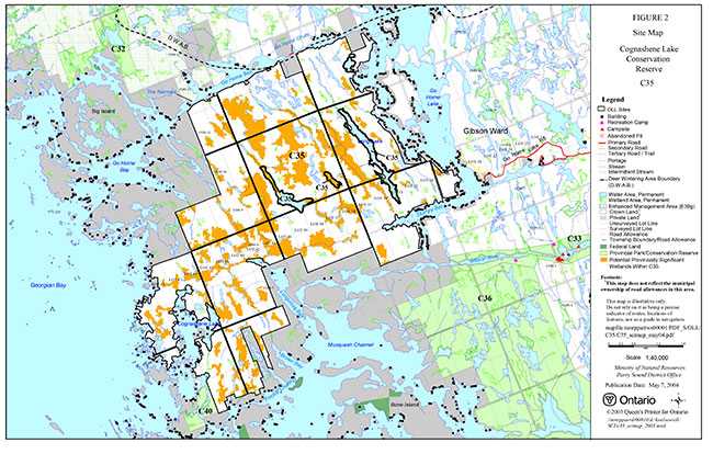
Enlarge Figure 2: Cognashene Lake Conservation Reserve Site Map
Figure 3: Cognashene Lake Conservation Reserve Site Map
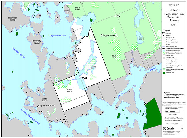
Enlarge Figure 3: Cognashene Lake Conservation Reserve Site Map