Cranberry Lake Provincial Park Management Statement
This document provides direction on the management of Cranberry Lake Provincial Park.
Cranberry Lake Provincial Nature Reserve Interim Management Statement
1985 Government of Ontario
January, 1986
Regional director’s approval statement
This Interim Management Statement will provide interim direction for the management of the Cranberry Lake Provincial Nature Reserve Park until a comprehensive Park Management Plan is prepared.
This statement will provide the basis for the subsequent preparation of the Park Management Plan.
I am pleased to approve this Interim Management Statement for the Cranberry Lake Provincial Nature Reserve.
Signed by:
Johnston
Regional
Northwestern Region
Introduction
The purpose of this Interim Management Statement is to identify:
- park values which are to be protected;
- resource management prescriptions necessary to protect these values; and
- restrictions on use of natural resources within the
This Interim Management Statement is not intended to replace a Park Management Plan. Rather it is intended to guide the use of natural resources and related activities within the park until such a time as a Park Management Plan is prepared.
The guidelines that have been developed are based on information contained in the Fort Frances District Land Use Guidelines.
Background information
Name: Cranberry Lake Provincial Nature Reserve
Proposed class: Nature reserve
M.N.R. District: Northwestern
Total area (ha): 2800 ha
Land
Water:
Site region: 5S-Lake of the Woods
Site district: 5S-2
Date in regulation: 85.01.24
Regional setting map:
Targets
1. Life science representation
|
site type/landscape unit |
species/communities |
|---|---|
|
Landscape Unit 31 - Rainy River Clay Plain |
Swamp and open and closed bog vegetative communities |
2. Earth science representation
|
geological theme |
feature |
|---|---|
|
Wisconsinan/North Bay Interstadial |
- Lake Agassiz - raised strandline |
3. Cultural resource representation
|
theme |
theme segment |
|---|---|
|
Unknown |
Unknown |
4. Recreation opportunities
|
day use |
car camping |
wilderness/backcountry |
|---|---|---|
|
N/A |
N/A |
N/A |
Inventories
|
level\type |
earth science |
life science |
cultural |
recreational |
other |
|---|---|---|---|---|---|
|
reconnaissance completion date |
1978 |
1978 |
|||
|
Detailed completion date |
Management guidelines
I. Land tenure
There are presently no forms of alienated land tenure within the park boundary.
Guideline
Requests for any form of land tenure will not be considered.
II. Land acquisition/disposition
There are four patented properties presently located within the park boundary and described as follows:
S 1/2 Lot 1, Con. 3 Pratt Township 65.56 ha.
E 1/2 of S 1/2 Lot 12, Con. 4 Sutherland Township 41.28 ha.
N 1/2 Lot 12, Con. 3 Sutherland Township 82.35 ha.
W 1/2 of S 1/2 Lot 11, Con.4 Sutherland Township 40.87 ha.
In addition, the park is largely surrounded by patented property.
Guidelines
The Ministry of Natural Resources will not actively seek to acquire the above described patented property pending the completion of the park management plan. The Ministry will however, enter into negotiations with property owners interested in disposing of property when such properties are considered significant to the management of the park.
The further disposition of Crown-owned lands will not be considered.
The Ministry will attempt to influence the use of private lands within and adjacent to the park when such uses are considered significant to the management of the park.
III. Existing/proposed development
There are no existing facilities or developments within the park with the exception of a bush trail extending along the top of the raised strandline.
Guideline
Proposals for park development will not be considered pending the completion of the park management plan. Park development will be limited to trails, necessary signage and interpretive facilities for research and educational purposes.
The present trail permits access into the nature reserve and to the patented properties listed above. This trail will be permitted to remain providing it does not detract upon known park values.
IV. Recreation activities
The only recreational activities that presently occur within the park area are a limited amount of sport hunting and to a lesser extent, wildlife viewing.
Guideline
The above mentioned recreational activities will be permitted to continue.
V. Commercial activities
A portion of one trapline is included within the park boundary.
A small amount of timber has been harvested in the past from isolated patches within the park.
The two small lakes within the park (Cranberry Lake and Marsh Lake)are heavily fished for bait by one local commercial tourist operator. No other commercial activities presently exist.
Guidelines
Trapping on the existing trapline will be permitted to continue within the park area. Proposals for trapline cabins will not be considered.
Timber harvesting will not be permitted in the park.
Commercial bait fishing operations will be permitted to continue. Since the licence utilizes an aircraft to gain access to the area, provision will be made for an aircraft landing permit under the Provincial parks Act.
Mineral exploration/extraction will be permitted to per the Fort Frances District Land Use Guidelines. This activity will only be authorized by the issuance of Exploratory Licence of Occupation under Section 190 of the Mining Act.
Aggregate extraction and the extraction of peat will not be permitted within the park.
VI. Native interests
There are no known Native interests in the park area.
VII. Natural resources
A number of natural resource values have been identified to date through the reconnaissance earth and life science inventories. These values include a raised strandline associated with glacial Lake Agassiz (Campbell Phase)and a distinct peatland unit exhibiting swamp and open and closed bog vegetative communities. Management efforts will be directed towards the maintenance and protection of these features.
VIII. cultural resources
No known cultural resources have been identified to date.
IX. Client services
Information on the earth and life science values of this nature reserve will be made available to the public in an attempt to foster an understanding and appreciation for this park.
X. Research
More detailed earth and life science inventories will be necessary prior to the preparation of the park management plan.
XI. Marketing
A marketing strategy for this nature reserve class provincial park will be addressed during the preparation of the park management plan.
Sources/references
Kor, P., Earth Science Inventory Checklist for Gameland - Raised Beach, O.M.N.R., 1978.
Noble, T., Ontario Nature Reserves Program- Life Science Inventory Check-Sheet for Cranberry and Marsh Lakes- Peatland, O.M.N.R., 1978.
Ontario Ministry of Natural Resources, Fort Frances District Land Use Guidelines, 1983
Gameland
a. Area description
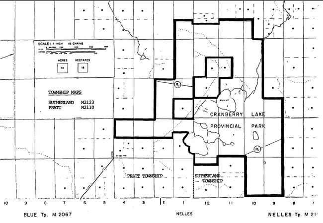
Area 6 covers approximately 2200 hectares located northeast of Gameland in Sutherland and Pratt Townships. The area is comprised primarily of peatlands and includes two small lakes (Marsh and Cranberry).
Current uses include resident fur trapping, bait fishing, moderate deer and small game hunting, as well as a small amount of timber harvesting. Peat potential is high, while potential for metallic minerals is low. Aggregate potential is generally low although the strand line has moderate potential.
Area 6 encompasses five private properties, including one permanent residence. Access to the residence is gained along a bush road from the south and follows the strandline northward. The remainder of the area is inaccessible by road.
b. Land use intent
The area is being recommended for park status. The proposed park candidate would provide representation of the bog, swamp and fen communities within landscape unit 31 (Rainy River Clay Plain), as well as a raised strandline of glacial Lake Agassiz. Boundaries of the candidate area have been revised so as to exclude lands of significant agricultural potential where these are located adjacent to areas presently being farmed.
In consideration of existing land uses within the area, it is further recommended that; most of these uses be permitted to continue. The exception to this would be commercial logging which is not recommended as a continuing use. An outline of those ongoing activities which are recommended for continuation is given in the Land Use Activity section, however it must be realized that further refinement of these recommendations may be required in some instances.
The Land Use Activity section also provides guidelines for how the Ministry will attempt to influence the use of private lands located within the recommended candidate. These guidelines could be refined as more information is gathered concerning the contribution of these lands towards meeting park objectives.
Until such time as the area is established as a park, it will be managed essentially as Crown lands with private land inholdings. Traditional uses of the area will be permitted to continue provided they do not jeopardize long term park objectives, or impact on known park values to the significant detriment of their value once the park is created.
c. Land use activity for area No. 6-Gameland
|
Activity |
Acceptable Yes/No |
Recommended Guidelines |
|---|---|---|
|
Aggregate Extraction |
No | |
|
Agriculture |
No | |
|
Bait Fishing |
Yes |
It is recommended that existing bait fishing operations be permitted to continue. |
|
Commercial fishing |
No | |
|
Cottaging |
No | |
|
Forestry |
No | |
|
Hunting |
Yes |
It is recommended that existing hunting activities be permitted to continue. |
|
Mining |
Yes |
It is recommended that mineral exploration/extraction be permitted to continue. |
|
Provincial Parks |
Yes |
Recommended for park status. |
|
Roads |
No | |
|
Rural Residential |
No | |
|
Sport fishing |
No | |
|
Tourism |
No | |
|
Trapping |
Yes |
It is recommended that existing trapping activities be permitted to continue. |
|
Wildlife viewing |
Yes |
|
|
Wild Rice Harvesting |
No | |
|
Urban development |
No |
Ontario Nature Reserves Program - Life science inventory check-sheet
Name: Cranberry and Marsh Lakes – Peatland
Map name: Arbor Vitae
Map number: 52D/16
UTM Reference: 400110
County, district or Regional Municipality: District of Rainy River
Latitude: 48 51’ N
Longitude: 94 21; W
Altitude minimum: 1125
Altitude maximum: 1150
Locality: Gameland
Township: Sutherland
Area: 4300 acres (1720 ha)
Forest Region and District: L. 12-Rainy River
Site Region and District: 5S-2
MNR Region and District: NWR-Fort Frances
Physical and biological features:
The Marsh and Cranberry Lakes area is a distinct peatland unit exhibiting swamp and pen and closed bog vegetative types. Successional dynamics associated with organic terrain is vividly illustrated as bog lakes and ponds represent the wetter portion of the progression from open water to drier site types associated with edge of the peatland unit. The western boundary of this feature is coincident with a northeast-southwest trending raised beachline associated with Glacial Lake Agassiz (Johnston, W.A., 1915).
Major information sources: Johnston, W.A., 1915
Evaluation and Priorities: This unit has potential as a candidate Nature Reserve.
Field notes
Field no.: 8-8 NWR
Date: August 26, 1980
Area name: Marsh Lake.
Location: 52D/16 (Arbor Vitae), 993116
Feature: bog
Abiotic components: slope -
aspect -
microclimate -
drainage -
substrate -
Biotic components: vegetation composition by stratum:
- Tree - open to treed, Sb
- Shrub - Chamaedaphne calyculata, Kalmia polifolia, Andromeda glaucophylla, in open; Ledum groenlandicum under Sb.
- Herb - Species poor, Carex spp.
- Bryoid -Sphagnum in hunmocks.
- Faunal notes - Marsh Hawk
Incidental notes: Photos – 2
- Typical species poor bog
Name: Gameland-Raised Beach
Map name: Arbor Vitae
Map number 52D/16
UTM reference: 000125
Latitude: 48°51’
Longitude: 94°22’
Minimum altitude : 355 m (1100 ft.)
Maximum altitude: 390m (1200 ft.)
Township: Pratt, Sutherland
Lot concession
Trends NE from Gameland, for 7 km along West side of Cranberry and Marsh Lakes; 20 km NE of Rainy River.
Area: 8446.0 acres ( 3418.1 ha)
Ownership: approx.85% Crown; 15% alienated.
Administration:
MNR region & district: NWR -Fort Frances
Aerial photographs- basemaps
- Year: 1965
- Roll: 33
- Flight line: 4836
- Numbers: 159-161
- Year: 1965
- Roll: 33
- Flight line: 4835
- Numbers: 244-247
Earth science features
A low, distinct, continuous feature, consisting of sand and gravel, representing a significant constructional raised strandline of glacial Lake Agassiz (Campbell Phase)
Sensitivity
Susceptible to gravel extraction, but is completely intact at present; farm road along its length has not adversely affected the ridge to date
Significance
Excellent representation of constructional strandline associated with glacial Lake Agassiz (Campbell Phase)
Major references:
Johnston, W., 1915.
Physical features:
A low, gently hummocky predominantly single ridge trends northeastward from Gameland, on hwy 671, and ends in a complex ridge system north of Marsh Lake, Sutherland Twp. The single ridge is roughly 8 km (5 mile) long, up to 250 m (800 ft) wide, and generally no more than 5-7 m (15-20 ft) high. The complex ridge system is discontinuous along a northwesterly trend for about 1.6 km (2.0 mile), up to 500 m (1500 ft) wide and no more than 5-7 m (15-20 ft) high. The community of Gameland is built on the southern end of this feature, where its distinct topographic form is readily visible in the cleared fields and housing lots. Highway 671 parallels the ridge for several hundred metres south of Gameland. Ia small gravel pit south of Gameland, it was observed that the ridge was composed of sand and gravel containing a high percentage of calcareous rock fragments. A farm road follows much of the length of the ridge to north of Marsh Lake; the material was observed to be similar in sample localities along this road. A low, flat wetland borders the ridge system on both sides.
The ridges were formed in a shallow glacial Lake Agassiz no more than about 12,000 B.P. The strength and continuity of the features probably indicates that they are littoral features formed in the lengthy Campbell Phase of the lake (Johnston, 1915, p.57,58). The high calcareous content indicates that the beach material was derived from the wave erosion of calcareous till, which was originally derived from the Paleozoic bedrock in Manitoba over which the Keewatin glacters traversed. The complex ridge system at the north end o·f the sand beach probably represents a complex spit formed in the circulating waters of the shallow lake. The relatively flat upper surface of the wide ridge may indicate sub acqueous formation. A general overall view of the surrounding countryside (see air photo mosaic attached)suggested that the feature may represent a baymouth bar or sand spit formed as the result of currents flowing northeastward deriving its material from the higher ground around Gameland. This is simply conjecture at this point, as more detailed studies are required.
The beach feature has remained relatively free from man’s influence. The southern portions are cleared and settled, forming the community of Gameland. North of the farmhouse east of Cranberry Lake, however, the ridge is marked only by a single track farm road and the occasional cutting. The ridge is otherwise well vegetated.
Significance:
Littoral features of the Campbell Phase of glacial Lake Agassiz are not uncommon in the Rainy River-Fort Frances area of Ontario; Johnston (1915, p.56-59)lists numerous such features. The Gameland occurrence is one of the best examples in the region because of its excellent form, high visibility and educational/scientific value, and its remarkable state of preservation in a dominantly rural environment. Other similar features (e.g. Spohn Township beach ridge, Wild Land Reserve beach ridge, Blue Township. beach ridge)often are readily visible and of high educational and scientific value, but are extensively developed, with the building of farms and roads on their surface. The interesting geomorphological situation of the Gameland sandbar presents questions which only more detailed study may answer. The nature and extent of the Lake Agassiz environment may be interpreted from the study of this feature and its surroundings.
Recommendations:
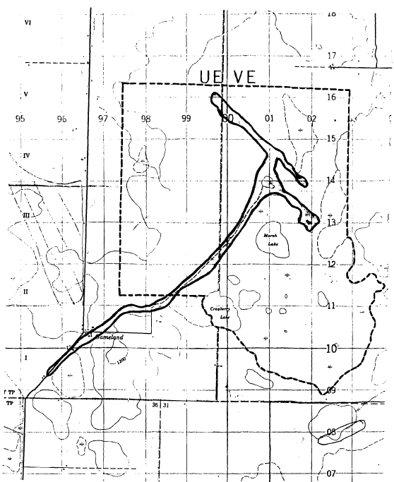
The feature is relatively untouched north of the farmhouse east of Cranberry Lake. South of Cranberry Lake, the feature lies entirely on private land. Much of this portion of the beach ridge is on Crown land, though it seems to cut through private land as well. It appears to be in little danger of being extensively altered at present. It is recommended that at least the portion of the beach ridge north of the Cranberry Lake farmhouse be set aside as a candidate Nature Reserve to ensure its continued protection. A 3450 ha (8525 acres) candidate boundary is suggested (see map attached). This boundary incorporates the salient properties of the beach ridge and includes the life science values of the Cranberry/Marsh Lakes wetland (see Life Science Systems Planning document, 1981).
Outline of glacial Lake Agassiz beach ridge, and recommended candidate Nature Reserve boundary (dashed line). Scale 1:50,000.