Dana-Jowsey Lakes Provincial Park Management Plan
This document provides direction on the management of Dana-Jowsey Lakes Provincial Park.
Approval statement
Dana-Jowsey Lakes Provincial Park is situated 30 kilometers west of the city centre of Timmins. This 2,538.3 hectare, undeveloped recreational class park offers the potential for a wide variety of outdoor activities tor local residents and tourists. Originally identified as a recreational park reserve in the early 1960's, Dana-Jowsey Lakes obtained provincial park status in May of 1989.
We are pleased to approve the Dana-Jowsey Lakes Provincial Park Management Plan, as the official policy for the management and development of this park. The plan reflects the Ministry’s intent to protect natural and cultural features of Dana-Jowsey Lakes Provincial Park and to maintain and develop high quality opportunities for outdoor recreation and heritage appreciation for both residents of Ontario and visitors to the Province.
R.D. Hunter
Regional Director,
Northeast Region
N.R. Richards
Director,
Parks and Natural Heritage Policy Branch
Juillet 22, 1992
Declaration d’approbation
Le parc provincial Dana-Jowsey Lakes est situé à 30 kilometres à l’ouest du centre ville de Timmins. Ce parc de loisirs, d’une surface totale de 2,538.3 hectares, offre pour l’avenir la possibilité d’une grande variété d’activités récréatives pour les gens de la régîon et les touristes. Au début des années 1960, le parc Dana-Jowsey Lakes fut à l’origine identifé comme une réserve de loisirs; en mai 1989, on lui a attribué le statut du parc provincial.
C'est avec plaîsir que nous accordons notre approbation au plan d’aménagement du parc provincial Dana-Jowsey l.akes, en tant que politique officielle pour la gestion et l’aménagement de ce parc. Le plan reflété l’intention du mînîstére de protéger les caractéristiques naturelles et culturelles du parc provincial Dana-Jowsey Lakes et d’offrir aux résidents et visiteurs de la province de l’Ontario l’occasion de jouir de possibilités recreatives de plein air de haute qualité et d’apprécier au maximum l’herîtage du parc.
Signed,
R.D. Hunter
Directeur regional
Region Nora-Est
Signed,
N.R. Richards
Directeur
Direction des pares et des zones de loisirs
Dana-Jowsey Lakes Provincial Park Management Plan summary
Dana-Jowsey Lakes is an area of high recreational and natural value. The area was first identified as a park reserve in the early 1960's and subsequently obtained provincial park status in May of 1989. The park covers 2,538.3 hectares. It is classed as a recreational provincial park, which supports a wide variety of outdoor recreational opportunities for large numbers of people in attractive surroundings. The goal of the park is to protect an existing regional and provincial recreational area providing high quality recreational opportunities. Of the four provincial park system objectives, Dana-Jowsey contributes principally to the recreational, heritage appreciation and tourism' objectives.
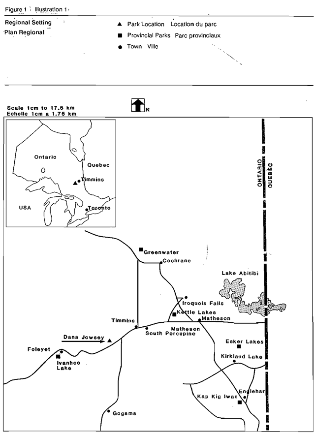
The park is situated approximately 30 km west of the city centre of the City of Timmins and is accessed via the Dana-Jowsey road running north off Hwy 101 west of Timmins (Figure 1).
Significant management policies are:
- sport hunting will be allowed subject to provincial hunting regulations.
- trapping will be phased out over a 21 year period or upon the licenses being transferred or lapsing,
- traditional passage through the park to areas north and west will not be obstructed.
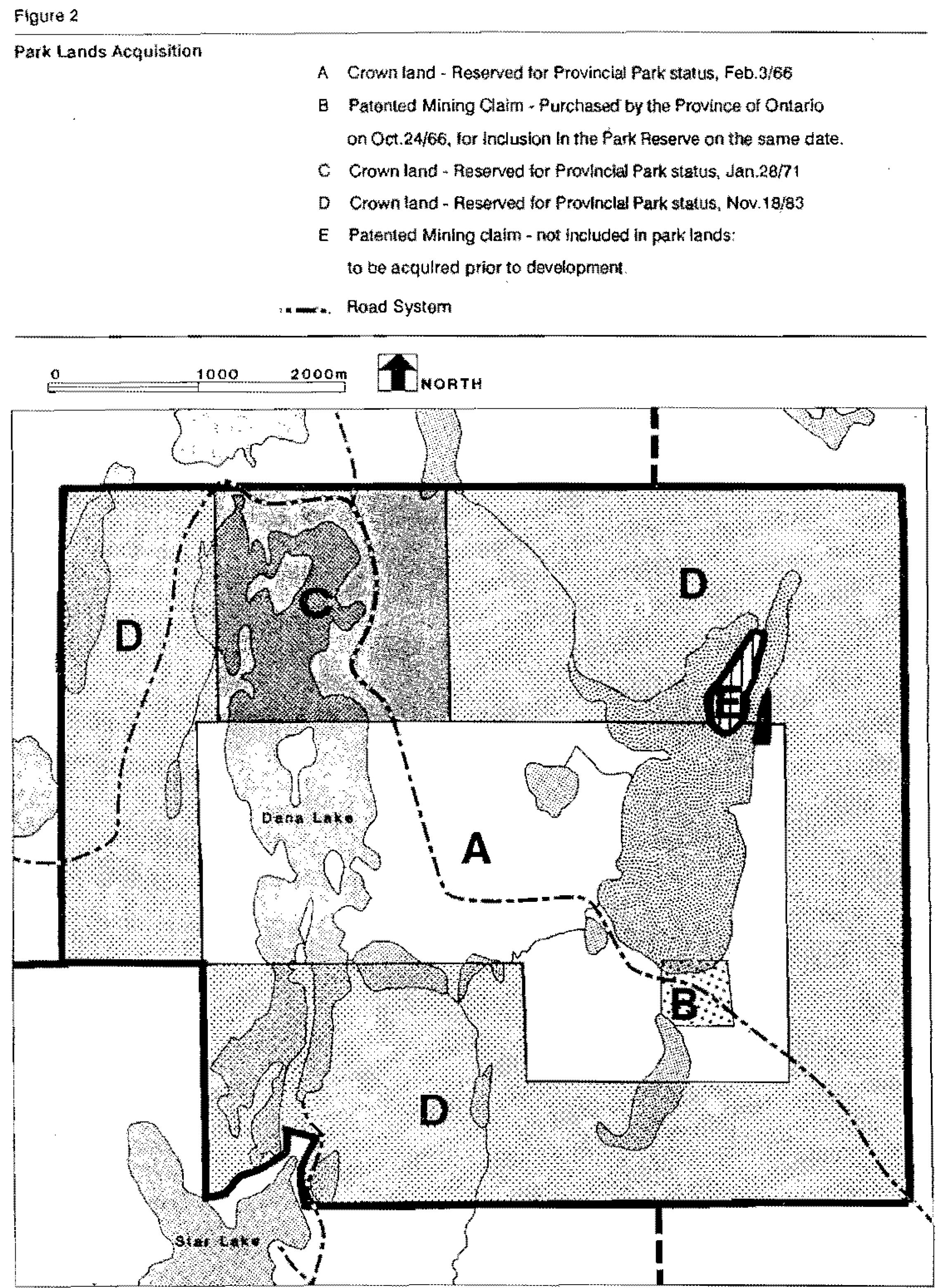
- the Ministry will continue efforts to purchase tor Inclusion in the park the 9.11 hectares patented mining c1aim located on Jowsey Lake.
- commercial forest operations, mineral exploration and mining will not be permitted.
- a life science study will be completed prior to development.
- stocking of Lake Trout and Splake will continue in Dana Lake.
- commercial fishing will not be permitted.
- Dana-Jowsey Lakes will be managed as an undeveloped, recreational class, provincial park until it is determined that additional recreational opportunities are required in the area.
Public comment to date has dealt with allowing sport hunting to continue, maintaining traditional passage through the park to areas north and west of the park and leaving as is the three lake access sites and three car camping sites until the development stage.
Minimal park development will occur, other than marking the boundary and erecting park regulation signs, until it is determined that additional recreational opportunities (camping and day-use) are required in the area.
The following priorities will be undertaken as funding permits;
- initiate phase-out of commercial trapping,
- develop a sign plan and erect signs,
- survey park boundaries,
- continue efforts to purchase the 9.11 ha patented mining claim,
- complete a life science study,
- prepare an information brochure,
- complete a development plan,
- complete site planning for actual development,
- construction of camping and day-use facilities.
Parcs Provincial Dana-Jowsey Lakes Un sommaire du plan d’aménagement
Le parc provincial Dana-Jowsey Lakes constituent une région de grande valeur sur les plan des loisirs et naturel. Ayant été reconnu, au début des années 1960 en tant que réserve de parc de loisirs, l’emplacement Dana-Jowsey a obtenu te statut de parc provincial au mois de mai 1969. Ce parc s'étend sur 2538.3 hectares de terrain, et, en sa capacité de parc de loisirs, il offre de nombreuses installations sportives en plein air au public, dans un paysage attrayant. Le but du parc est de protéger un terrain régional et provincial existant qui offre de nombreuses installations sportives de qualité supérieure. De plus, le parc Dana-Jowsey répond à trois des quatres objectifs qol ont été établis en matière da politique sur les parcs, notamment, les loîsirs, l’appréciation des biens culturels et le tourisme.
Le parc est situé à environ 30 km à l’ouest du centre commercial de la ville de Timmins, et on peut s'y rendre en prenant la route 101 Nord jusqu'au chemin Dana-Jowsey. (illustratlon 1)
Les politîques de gestion suivantes sont en vigueur :
- la chasse sportive est permise, sujette aux règlements provinciaux sur la chasse;
- le piègeage sera supprimé progressivement sur une période de 21 ans ou sur cession ou déchéance des permis;
- aucune barriére ne sera installée pour interdire le passage des véhicules aux régions au nord et à l’ouest du parc;
- le ministère maintenira les efforts en cours pour acheter la concession minière brevetée de 9, 11 hectares, située sur le lac Jowsey afin de l’ajouter au parc;
- toute exploitation commerciale, soit forestière, soit minière, est interdite;
- une étude sur les sciences de la vie sera effectuée avant l’aménagement;
- l’approvisionnement du lac Dana en de truite fardée et de truite moulac continuera.
- la pêche commerciale est interdite.
- ce parc sera géré en tant que parc de loisirs provincial sous-développé jusqu'à ce qu'on trouve que des installations sportives additionnelles sont nêcessaires dans la région.
A date, le public a fourni des commentaires touchant l’autorisation de la chasse sportive, le droit de passage traditionnel des véhicules aux régions situées au nord et à l’ouest du parc, le fait de laisser à leur présent état les trois voles d’accès et les trois terrains de camping peur automobiles, jusqu'à l'étape de l’aménagement.
Il n'y aura qu'un aménagement minimal dans le parc, sauf le démarcation des limites du parc et l’affichage des rêglements, jusqu'à ce qu'il soit déterminé si le parc requiert d’autres installations récréatives, tels le camping et l’usage le jour.
Les projets suivants seront effectués en fonction du financement :
- élimination progressive du piégeage commercial
- création d’un plan sur l’affichage et installation des affiches
- arpentage des limîtes du parc
- continuation des tentatives d’acheter la concession minière brevetée de 9, 11 hectares
- rédaction d’une étude sur les sciences de la vie
- rédaction d’un dépliant publicitaire
- mise à point d'une strategié sur la mise en valeur
- mise à point d'un plan de vue de l'amenagement futur
- construction de sites de camping et d'installations pour un usage quotidien.
1.0 Introduction
Dana-Jowsey Lakes Provincial Park is a 2,538.3 hectare recreational class provincial park. It is located approximately 30 kilometres west of the City of Timmins city centre, and approximately 700 kilometres north of Toronto (Figure 1). The park is situated approximately three kilometres north of Highway 101 at the junction of four townships; Whitesides, Keefer. Denton, and Carscallen. It is located in the Timmins District of the Ontario Ministry of Natural Resources.
Dana-Jowsey Lakes Provincial Park obtained park status on May 24, 1989 (Ontario Regulation 290/89). Early In the 1960's the area was identified as having high recreational values ideal for park development. Proposed boundaries for a park reserve were established. Land securement and withdrawal from mining activity was accomplished through four stages (Figure 2).
The park provides protection of significant recreational opportunities for present and future generations. The development, existing today, results from past timber operations and the Timmins District access point programme. This includes a road system and three access to water sites. The park is presently utilized for boating, fishing, hunting, swimming, picnicking and other related outdoor recreational activities.
Recreational demand estimates indicate low development pressures for the area in the near future. Within a 1 ½ hour drive of Dana-Jowsey Lakes are four existing, developed Provincial Parks: Kettle Lakes 60 kilometres east, Ivanhoe Lake 60 kilometres west, Halfway Lake 150 kilometres south and Greenwater 100 kilometres north. These four parks provide a total of 614 developed campsites and 950 day use parking spaces. Average occupancy during July August for Greenwater is 33%, Ivanhoe 54%, Kettle Lakes 44% and Halfway 67% (1990). Between these four parks, there is sufficient capacity to meet present and future user demand. Development of Dana-Jowsey Lakes will be undertaken when user demand levels meet or exceed existing capacity.
This plan establishes for the area, short and long term resource management policies. A companion document, the Dana-Jowsey Lakes Provincial Park Background Document to the Management Plan, summarizes the research which led to the development of the policies. It is available upon request at the M.N.R. Timmins District Office. Broad direction tor the Dana-Jowsey Lakes Management Plan is provided in the Timmins District Land Use Guidelines,
2.0 Classification
Dana-Jowsey Lakes Is classified as a Recreation Park in accordance with the 1978, Cabinet of Ontario approved, Ontario Provincial Parks Planning and Management Policies. Recreation parks are areas which support a wide variety of outdoor recreation opportunities for large numbers of people in attractive surroundings.
3.0 Goal
To provide a variety of outdoor recreational opportunities and to protect the natural, cultural and recreational environments in Daina-Jowsey Lakes Provincial Park.
4.0 Objectives
Dana-Jowsey Lakes will contribute, initially through management policies, to the protection of the area and subsequently to the achievement of the recreation, heritage appreciation and tourism
The objectives consistent with developed recreational provincial parks and the goal of the Ontario Provincial Park System.
4.1 Protection objective
To protect significant elements of the natural and cultural landscape of Dana-Jowsey Lakes Provincial Park.
Dana-Jowsey Lakes contains a variety of natural, cultural and recreational features which will be protected through appropriate zoning and management. Features to be protected include sandy beaches, glacial geomorphology, a coldwater lake trout fishery and the scattered immature, mature and overmature red and white pine stands around Dana Lake.
4.2 Recreation objective
To provide outdoor recreation opportunities ranging from high-intensity day use and camping to low intensity wilderness experiences.
Existing and excellent future potential outdoor recreational opportunities may be developed, as demand warrants, including camping, swimming, boating, picnicking, angling, hiking, and other related outdoor activities.
4.3 Heritage appreciation objective
To provide opportunities for exploration and appreciation of the outdoor natural and cultural heritage of Dana-Jowsey Lakes.
The park will offer unstructured opportunities (i.e. self use facilities verses personal services programs) for visitors to appreciate the natural and cultural features of the park and the Timmins and Chapleau areas.
4.4 Tourism objective
To provide Ontario’s residents and out-of-province visitors with opportunities to discover and experience the distinctive regions of the Province.
Dana-Jowsey Lakes will support local and regional tourism through protection and subsequent development by providing day-use and camping opportunities for both local residents and tourists. Through publications and staff contacts, park users will be encouraged to explore the park as well as other sites and attractions in the Timmins, Gogama and Chapleau areas.
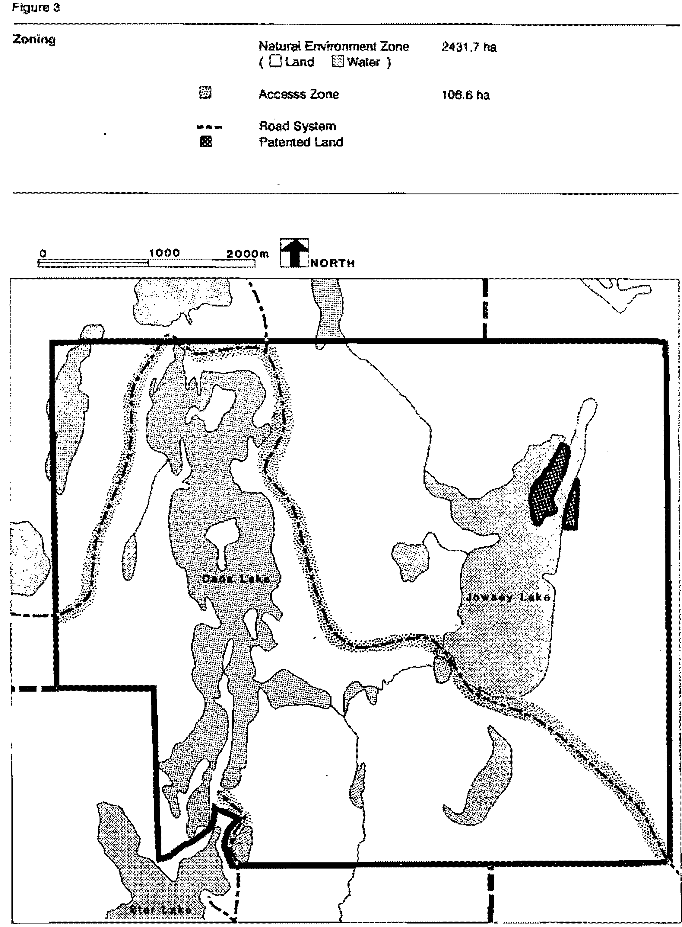
5.0 Zoning
Dana-Jowsey Lakes utilizes two zones: natural environment and access (Figure 3).
The zoning configuration shown in this plan has been developed on the basis of best available information. More detailed information is required in order to identify specific life science features or ecological associations of regional or provincial significance. This work will be carried out when funds become available. Revisions to the plan could be initiated depending on the study recommendations.
5.1 Natural environment zone
The natural environment zone encompasses approximately 95-8% of the park area (2431.7 hectares). The zone contains representative landscape units in the park. Minimal development required to support low-intensity recreational opportunities such as hiking, canoeing, fishing, wildlife viewing, cross-country skiing and other back country uses may be permitted. Development in this zone will be limited to trail systems, signs, and viewing stations. Minor tree removal will only be permitted where there is a threat to human safety and property or where it is necessary for the development or maintenance of low intensity recreational opportunities.
5.2 Access zone
The access zone, 106.6 hectares or 4.2% of the park area, includes the present access roads, the adjacent lands along the road right-of-ways and water access boat launch sites. Only minimal development (i.e. signs, parking areas) required to provide user access to park lands and lakes is permitted in this zone. The zone maintains traditional passage through the park for those persons wishing to access recreational opportunities outside the park to the north and west (i.e. cottagers, hunters, fishermen, canoeists, etc.) and water access/boat launch locations on Dana Lake and Jowsey Lake.
6.0 Resource management policies
The park will be managed in accordance with the general planning and management policies for recreational class provincial parks (Ontario Provincial Parks Planning and Management Policies 1978) and the specific management directions provided below 10 meet special resource requirements.
6.1 Landform management
The management of land resources will emphasize the maintenance of natural landscapes, Commercial mineral exploration and mining will not be permitted. Surface extraction of aggregates (gravel, fill, beach sand) will not be permitted for any purpose.
No utility lines or right-of-ways may be developed except those required to service the park, and these will be restricted to the access and development zones. All development will be in accordance with approved development and sites plans. Utility lines and right-of-ways will be restricted to the access zones or future development zones, development concepts will respect, and have regard for the sensitive nature of steep slopes found along the shore of Dana Lake and the esker complexes (Figure 4).
The Ministry will continue efforts to purchase for inclusion in the park, the 9.11 ha, patented mining claim (surface and mineral rights) located on Jowsey Lake (Figure 2).
Leases, land use permits and licenses of occupation will not be issued within the park.
6.2 Vegetation management
Vegetation in the park will be managed to emphasize the maintenance of an evolving natural succession, A Life Science Study (Inventory) will be completed prior to development Zoning changes may be required as a result of the identification of unique or sensitive plant communities to adequately protect those areas.
Commercial forest operations will not be permitted. Removal of trees will be permitted where a possible threat to human safety and/or property exists or where required to meet such park objectives as the provision of recreational opportunities and facility development.
Prescribed burning will not be permitted. Wildfire in all zones will be suppressed.
Aerial or ground spraying of pesticides will not be permitted unless the park is seriously threatened by Insects or disease. At such time, all spraying will follow guidelines established by the Ministry of Natural Resources and the Ministry of Environment.
Picking of edible wild plants and berries will be permitted for personal consumption. Commercial ventures will not be permitted.
Native plant species may be planted it required in any zone. Non-native plant species will not be deliberately introduced In any zone except on a limited scale in development zones and for the purposes (i.e. landscaping, etc.) described in the 'Recreation Parks' section cl the "Ontario Provincial Parks Planning and Management Policies".
Development concepts will respect and take into consideration the unique and sensitive nature of the mature and overmature scattered red and white pine along the eastern, northern and western shore of Dana Lake (Figure 4).
6.3 Fisheries management
Dana and Jowsey Lakes are popular sport fishing lakes. Fisheries management programs undertaken in the park will be consistent with the Timmins District Fisheries Management Plan (1989).
Sport fishing will be encouraged within the park. Use of live bait will be permitted. Use of power boats will be permitted on all water bodies within the park.
Commercial fishing, including commercial bait fishing, will not be permitted in the park.
Fish stocking strategies with regard to Dana Lake will ensure the continuance of Dana Lake as a viable lake trout fishery with annual stocking of lake trout. This strategy will provide optimum angler opportunities on a put and take
or put and delayed take
basis. Dana Lake has had a consistent annual stocking programme since 1950.
The pickerel fishery in Jowsey Lake is sustained through natural reproduction. The fishery will be periodically monitored and if required, fishery management techniques will be applied to ensure this condition is maintained or enhanced.
Development concepts will respect and take into consideration the sensitive nature of the lake trout fishery in Dana Lake with emphasis on possible changes in water quality and the sensitive and fragile nature of the known pickerel spawning beds at the south end of Jowsey Lake (Figure 4).
Cooperative projects to enhance the park’s fishery will be encouraged with adjacent landowners, sportsman groups or other community groups, No park specific angling regulations are proposed, but may be developed If conditions warrant.
6.4 Wildlife management
Wildlife viewing will be encouraged. Present Information indicates no significant, unique or sensitive wildlife areas. A life science study (Inventory) will be completed prior to the park development stage. If sensitive, unique or significant areas are identified, zone changes may be required to adequately protect these areas.
Sport hunting will be permitted in the park subject to provincial hunting regulations. At the time of development, sport hunting will be reassessed. Sport hunting will also be reassessed dependent upon a zoning change as a result of the identification of sensitive, unique or significant life science areas.
The park will not be included in many commercial bear management area established for any purpose including bailing or hunting.
Non-native wildlife species will not knowingly be introduced to the park.
The portions of commercial trap lines TI-17, TI-18 and TI-19 within the park, will be withdrawn from those traplines licenses, and phased out in accordance with MNR policy P.M.1.00. This will occur over a 21-year period (by January 1, 2010) or upon the licenses being transferred or lapsing.
Trapping or other control methods for nuisance and diseased animals will be permitted under the strict supervision of Ministry of Natural Resources staff.
7.0 Operations policies
A park operations plan in accordance with parks management policy, P.M. 2.49, addressing all current aspects or park operations will be prepared. The plan will be updated from time to time it and when the operations criteria for the park changes.
7.1 Visitor services
In accordance with the regional visitor services plan, visitor services programs and marketing will be limited to a basic level. Emphasis will be placed on a passive program and self-use facilities. The use of volunteers to facilitate program delivery will be encouraged.
Information Component: A park publication will be developed which will provide descriptions of the park’s resources, themes and the Ontario Provincial Parks system. No on-site interpretive display or visitor programing is planned for the park prior to development.
Interpretation Component: Major themes to be interpreted will include the history of the Porcupine Gold Camp, base metals mining and boreal forest ecology.
Recreation Component: The direction of the recreation component of the program will be to provide information about the recreational opportunities in the park and the surrounding area. Emphasis will be on self use activities such as swimming, boating, hiking, wildlife viewing, angling and picnicking
7.2 Research
Research which contributes to the knowledge of Earth and Life Science, cultural and recreational values of the park will be encouraged. All research will require approval by the Ministry of Natural Resources. Requests will be screened and monitored for any negative impact upon the park resource. All collecting will be strictly controlled.
7.3 Recreation management
Dana-Jowsey Lakes will be managed as an undeveloped recreational class provincial park until such time as the Ministry of Natural Resources de1ermines that additional recreational opportunities are required in the area.
The three traditional car camping sites, used prior to park establishment were closed to overnight camping November, 1991. Closure was due to continuing negative impact on the environment and the park resource, Public health concerns was also a contributing factor. These three sites will remain closed and will be rehabilitated.
Park user patterns and behaviour will be intermittently monitored. Enforcement of park regulations or implementation of park policies will be the responsibility of the Ministry of Natural Resources staff.
Snowmobiles and power boats will be permitted in Dana-Jowsey Lakes Provincial Park subject to standard legislation regulating their use.
All terrain vehicles, motorbikes, four-wheel-drive vehicles and any/all such forms of mechanized travel will only be permitted on existing park roads, subject to Ontario regulations (e.g.: the Highway Traffic Act, the Provincial Parks Act, etc.). Use of such vehicles will not be permitted elsewhere in the park.
Refuse generated by park users will be disposed of outside the park through local facilities.
7.4 Tourism services
Currently commercial tourism services are not provided within the park nor are any envisioned at this time. Future proposals for permanent services will require an amendment to the park management plan. This will ensure public involvement prior to approval of any proposal. Temporary, small scale services (e.g. canoe rentals) may be approved in the interim. All interim services will require approval of the District Manager and must be in accordance with policy direction and the guidelines for tourism services in Ontario Provincial Parks. All requests will be screened and monitored for any negative impact upon the park resource.
8.0 Development policies
As previously identified, the need for increased capacity of developed recreational opportunities (i.e., camping and day-use) in the area is not needed at this time.
When the need for an increase in developed recreational opportunities is demonstrated and funding becomes available, development of the park will then be undertaken. Prior to development, zoning will be reassessed, a development plan and site plans will be completed.
During the interim period, three existing water access sites will be allowed to remain (Figure 5). No additional sites for water access will be allowed and no car camping sites developed or re-opened. No expansion of the existing sites will be allowed. Improvements or maintenance on the existing sites may be undertaken by the Ministry of Natural Resources depending upon available funding. Existing sites may be closed if demonstrated that continued existence is having a negative Impact on the park resource, human health or the environment.
During the interim period, the existing road system will be allowed to remain. No addition or re-routing to existing roads not new roads will be allowed in the park. Maintenance on the present roads will be limited to available funding and need. All road work (i.e. grading, maintenance, culvert repair/replacement etc.) which may be required on that portion of road traversing the known and sensitive pickerel spawning beds at the south end of Jowsey Lake will require the approval of the District Manager. Access out of the park to the north and west will continue to be permitted. The need for this access route will be periodically reassessed.
A reassessment of existing development will be undertaken at the site planning stage, Figure 5 identifies the locations and nature of present development. The exact nature and location of required facilities to be constructed during development will be identified and confirmed through the site planning stage.
A park sign plan will be developed and signs will be erected to meet basic user informa1ion needs depending upon available funding.
9.0 Implementation priorities
Upon approval of the Dana-Jowsey Lakes Provincial Park Management Plan, the following prioritized schedule will be implemented for park management policies. Projects will be undertaken subject to availability at funding.
Phase one priorities:
- initiate revisions to the Timmins District Land Use Guidelines.
- initiate phase out of commercial trapping in the park as per policy P.M. 1.00. (Provincial Parks Policy - Implementation Details). Trapping will be completely phased out by January 1, 2010.
- develop a sign plan for the park emphasizing basic user information.
- erect signs as per the sign plan.
- park boundaries will be delineated and marked with appropriate signs.
- continue efforts to purchase, on a willing seller basis, the 9.11 hectares patented mining claim existing within the park boundaries.
Phase two priorities:
- complete an in depth life science study (inventory).
- develop a park operating plan.
- develop an information brochure/brochures and map with regard to basic park information, regulations, management policies, marketing, tourism and visitor services.
Phase three priorities:
- complete a development plan including the site planning for eventual facilities.
Phase four priorities:
- development of park facilities as per the approved development and site plans.
- phase out existing facilities which are non-compatible with the approved site plan concept.
- re-assess the hunting policies with a view to user conflicts.
- develop all applicable management/operating plans and strategies as per Ministry of Natural Resources policy P.M. 2.49.
10.0 Summary of public consultation
Public involvement in the management planning process for Dana-Jowsey lakes Provincial Park was initiated on August 31, 1988. At that time a news release was circulated to the media, notice or intent and request for comment was published as a paid advertisement in local papers and a letter of intent and request for comment mailed to interested groups, individuals, government agencies and adjacent landowners. Background reports, an earth science inventory, the Dana-Jowsey Interim Management Statement and historical files were available for public review.
On April 14, 1990 notice of a public information center inviting public participation in the review of the preliminary plan was published as an advertisement in the local papers. Copies of the preliminary plan, background document and an English/French summary were mailed to interested groups, individuals, government agencies and adjacent landowners inviting participation and comment a news release was given to the local media.
The public information center was held on May 16, 1990 at the Ministry of Natural Resources, Timmins District office. All parties contacted during his stage of the process were requested to submit their comments regarding the preliminary plan no latter that July 6, 1990 to the Timmins District Manager. Copies of the plan, background document, and English/French summary were made available to the public at the Timmins District office up to July 6, 1990. Copies of all comments received are available at the Ministry of Natural Resources, Timmins District office.
Significant issues identified to the public in the preliminary plan were:
- sport hunting
- trapping
- traditional access through the park to recreational opportunities north and west of the park, including a cottage lot development on Luquer Lake
- a patented mining claim entirely enclosed by park lands
- three existing lake access sites and three existing car camping sites
Written and verbal comments were received throughout the public consultation process. There was general satisfaction and agreement with the management policies presented in the preliminary plan. Public comment focused on three significant issues recommending the following related management policy directions:
- allow hunting within the park
- allow unrestricted passage through the park to traditional recreational areas outside the park to the north and west
- maintain traditional recreational uses in the park.
The final park management plan incorporates comments received during all stages of public consultation.
10.1 Future public consultation and plan review
This management plan will be reviewed at least once every ten (10) years to re-confirm or amend resource management, operational and development policies. Reviews will include public consultation.
Minor amendments will be made in accordance with approved planning policy, major amendments having broad implications for resource management, operational and development policies will include public consultation.
11.0 References
Brown, Carson L. The Golden Porcupine. 1972.
Canadian Department of Mines and Natural Resources, A Forest Classification for Ontario: Forestry Services bulletin 89. 1937.
Chapmon and Thomas, The Climate of Northern Ontario. Climatological Studies. No. 6. Department of Transport Canada, 1968.
Department of the Environment. Forest Regions of Canada, Publication No. 1300. Canadian Forestry Service, 1972.
Department of Transport Canada, Climatic Normals, Volumes 3 and 4. Meteorological Branch, 1968.
Environment Canada, Canadian Normals. Volume 3. 1975.
Forma. Gary, Caring for History. Managing Cultural Resources in Ontario Provincial Parks, Ontario Ministry of Natural Resources, 1982
James Bay Frontier Association. Tourism Survey, 1979 and 1980.
Laventhal and Horwath, Ontario Provincial Parks Marketing Research Study, 1988.
Ontario Land Registrar’s Office, Land Title Files. Cochrane Ontario.
Ontario Mining Recorder’s Office, Mining Claim Records for Whitesides Twp., Denton Twp., Carscallen Twp. and Keefer Twp., Timmins Ontario.
Ontario Ministry of Culture and Recreation, Archaeology in North Eastern Ontario- Searching for Our Past. 1981
Ontario Ministry of Natural Resources, A Framework for Resource Management Planning in M.N.R., Policy and Planning Secretariat, 1986.
Ontario Ministry of Natural Resources, Archeology in the Timmins District. 1974.
Ontario Ministry of Natural Resources, A Tropical Organization of Ontario History, Historic Sites, Branch, Division of Parks, 1975.
Ontario Ministry of Natural Resources, Boundary Map. Dana-Jowsey Lakes Provincial Park. Surveys and Mapping Branch, Toronto.
Ontario Ministry of Natural Resources, Dana-Jowsey Lakes. Candidate Park Interim Management Statement. 1985.
Ontario Ministry of Natural Resources, Fire History Files. Fire Management, Timmins District.
Ontario Ministry of Natural Resources, Fisheries Management Plan. Timmins District. 1989.
Ontario Ministry of Natural Resources, Forest Management Files, Forest Management, Timmins District.
Ontario Ministry of Natural Resources, F.R.I. Maps, Whitesides Twp.., Denton Twp., Carscallen Twp. and Keefer Twp., 1981.
Ontario Ministry of Natural Resources, Geographical Names Section, Lands Branch.
Ontario Ministry of Natural Resources, Historical files, Parks and Recreational Areas Branch, Timmins District
Ontario Ministry of Natural Resources, Kettle Lakes Provincial Park Master Plan. 1979.
Ontario Ministry of Natural Resources, Lake Files for Dana Lake. Jowsey Lake and Whitesides Lakes. Fish and Wildlife Branch, Timmins District.
Ontario Ministry of Natural Resources, Lands Files, Lands Branch, Timmins District.
Ontario Ministry of Natural Resources, Land Use Guidelines, Timmins District, 1983.
Ontario Ministry of Natural Resources, Mining Hazard Files, Timmins District Office, Lands Branch.
Ontario Ministry of Natural Resources, Northeastern Ontario Strategic Land Use Plan. 1982.
Ontario Ministry of Natural Resources, Northern Region Park Reserves, an Assessment Report with Recommendations. 1978.
Ontario Ministry of Natural Resources, Ontario Fisheries Acidification Report Series No. 86-05.
Ontario Ministry of Natural Resources, Ontario Provincial Parks Annual Statistics. 1983, 1984, 1985, 1986 and 1987.
Ontario Ministry of Natural Resources, Ontario Provincial Parks Management Planning Reference. 1978.
Ontario Ministry of Natural Resources, Sensitive Fisher and Wildlife Areas Document. Timmins District, Fish and Wildlife Branch, Timmins District.
Ontario Ministry of Natural Resources, Fur Management Files. Fish and Wildlife Branch, Timmins District.
Statistics Canada, Census Canada. 1986.
University of Waterloo, An Assessment of Earth Science Process and Features for Land Use Planning of Dana-Jowsey Lakes Candidate Provincial Park. 1983.