Draper Township Conservation Reserve Management Statement
This document provides policy direction for the protection, development and management of the Draper Township Conservation Reserve and its resources.
Approval statement
We are pleased to approve this Statement of Conservation Interest for Draper Township Conservation Reserve (C29).
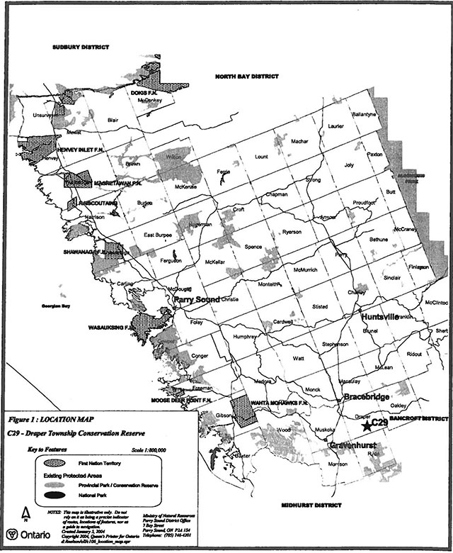
Draper Township Conservation Reserve is an 81 hectare area of Crown land, located about 11 kilometres southeast of the town centre of Bracebridge. It is located in southern Draper Ward of the Town at Bracebridge in the District Municipality of Muskoka. It consists of two separate parcels of Crown land, and is surrounded almost entirely by privately owned lands, which are not part of this conservation reserve.
This conservation reserve, located in ecological Site District 5E-8, contains excellent representation of sugar maple and white pine forests growing on low rolling hills with open wetlands, as well as several other combinations of vegetation and land forms.
Draper Township Conservation Reserve is one of 378 new protected areas approved through Ontario’s Living Legacy Land Use Strategy, aimed, in part, at completing Ontario’s system of parks and protected areas.
During the Lands for Life
planning process, the public was widely consulted and provided valuable input into what became Ontario’s Living Legacy Land Use Strategy. Comments received during that time, and during consultation related to the formal Public Lands Act regulation of the boundaries of this conservation reserve, were generally supportive of the protection of this area. Stakeholders who provide comment during the earlier consultation for this site were subsequently consulted regarding the draft Statement of Conservation Interest and their comments were considered in the finalization of this document.
This Statement of Conservation Interest provides guidance for the management of the conservation reserve and provides the basis for the ongoing monitoring of activities. More detailed direction is not anticipated at this time. Should more complex resource management or conservation issues arise or significant facility development be considered, then a detailed Resource Management Plan will be prepared with full public consultation.
Draper Township Conservation Reserve is managed under the direction of the District Manager and the Bracebridge Area Supervisor of the Ministry of Natural Resources, Parry Sound District.
Approved by: R. Griffiths
District Manager
Parry Sound District
Approved by: Ron Running
Regional Director
Southern Region
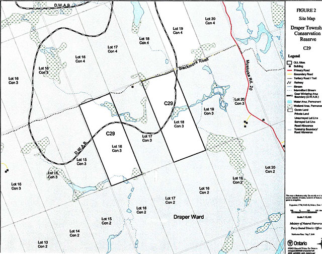
Enlarge Figure 2: Site Map - Draper Township Conservation Reserve (C29)
1.0 Introduction
Ontario’s Living Legacy, the result of an extensive planning process that began in early 1997, culminated in the approval in July 1999 of a Land Use Strategy that identifies the intended strategic direction for Crown land, including the completion of Ontario’s system of parks and protected areas. This process, which included extensive public consultation, resulted in the recommendation for regulation of 378 new protected areas, including Draper Township Conservation Reserve (C29).
Draper Township Conservation Reserve is an 81 hectare area of Crown land, located about 11 kilometres southeast of the town centre of Bracebridge. It is located in southern Draper Ward of the Town of Bracebridge in the District Municipality of Muskoka. It consists of two separate parcels of Crown land, and is surrounded almost entirely by privately owned lands, which are not part of this conservation reserve.
This conservation reserve, located in ecological Site District 5E-8, contains excellent representation of sugar maple and white pine forests growing on low rolling hills with open wetlands, as well as several other combinations of vegetation and land forms.
Access is provided to the north side of the eastern block of this site by the Blackmore Road, from Muskoka Road 20. Both blocks of the site are used for big game hunting. They do not appear to experience significant use for other recreational activities.
Conservation reserves are established under the authority of the Public Lands Act, Ontario Regulation 805/94. Draper Township Conservation Reserve was established by Ontario Regulation 148/02 on May 8, 2002.
A Statement of Conservation Interest (SCI) is prepared under the direction of Procedural Guideline a - Resource Management Planning (PL. Procedure 3.03.05). The purpose of this SCI is to identify and describe the values of Draper Township Conservation Reserve. The SCI also outlines the activities that currently occur within the conservation reserve and provides guidelines for the management of current and future activities in the context of protecting the natural, recreational and cultural values.
1.1 Background information
Name: Draper Township Conservation Reserve (C29)
Site Region/District: Georgian Bay 5E-8
OMNR Administrative Region/District/Area: Southern Region/Parry Sound District/ Bracebridge Area
Total Area (ha.): 81 hectares
Regulation Date: May 8, 2002 (O.Reg. 148/02)
First Nations: Robinson-Huron Treaty and Williams Treaty
OBM map sheets: 10 17 6400 49750
Topographic Map: Gravenhurst 31 D/14
UTM co-ordinates: 17T 64240 497950 (Centroid Lot 16),17T 64340 497990 (Centroid Lot 18)
1.2 Representation
Earth science representation:
Reconnaissance surveys and review of available technical materials have indicated that this site does not provide significant representation of bedrock or surficial geological features or processes.
Life science representation:
This site provides representation of a range of forest types on a weakly broken shallow sandy till plain in ecological Site District 5E-8.
Cultural resources representation:
Recent regional evaluation (OMNR, 2003) does not indicate any significant potential for cultural heritage sites within this conservation reserve. Neither detailed cultural research nor inventory has been carried out for this conservation reserve. Site evidence suggests a history of logging, and possibly homesteading.
Recreational opportunities:
A recreational inventory report was prepared for this site based on existing knowledge and data sources of MNR staff and a recent site inspection (Gavel, 2003). The site is currently used primarily for hunting. The Blackmore Road and the road allowance trail that extends westward are used by snowmobiles and all-terrain vehicles. The landscape of the site has potential for other trail uses, but is not known to be used for such at this time.
1.3 Survey work
| Survey Level | Earth Science | Life Science | Cultural | Recreational | Other |
|---|---|---|---|---|---|
| Reconnaissance | Blackbum, 2003 | Woodhouse, 2002 | OMNR, 2003 | Gavel, 2003 | None |
| Detailed | None | None | None | None | None |
| Requirement | None | Monitor the status/presence of significant species and associations. | Research to be encouraged | Monitor use impacts | None |
2.0 Values to be protected
The conservation reserve is located entirely within Hills' (1959) ecological Site District 5E-8. Values include earth science, life science and recreational/aesthetic values, with an emphasis on the life sciences.
2.1 Earth science:
(Earth science information, unless otherwise noted, is taken from Blackburn, 2003)
Bedrock:
Draper Township Conservation Reserve lies within the western part of the Fishog Domain, Algonquin Terrane of the Central Gneiss Belt of the Proterozoic Grenville Province. (Easton 1992a). There is little bedrock exposure within the site, so specific bedrock composition of the local bedrock is undetermined.
The Grenville Province is the product of thrusting and imbrication of the crust to the northwest as it collided with a continental landmass to the southeast. The Grenville Orogeny, circa 1140 to 1070 million years ago, culminated more than 500 million years of crustal evolution. The eroded roots of the products of these events are displayed in the complexly metamorphosed and deformed rocks of the region (Easton, 1992b, p.1302).
The Algonquin Terrane is one of four lithotectonic terranes of the Central Gneiss Belt. Within the Algonquin Terrane, the Fishog Domain consists of older migmatitic tonalite gneisses of unknown protolith, and a sequence of metasedimentary gneisses that contain quartz-rich and calc-silicate rich layers. These are intruded by a suite of younger, granodiorite and magmetite bearing syennogranite plutons cut all other units in the area. These syenite bodies can be traced west to the boundary with the Go Home Domain. In the western parts of the Domain, the plutons form elongate Domes. Metasedimentary and migmatitic tonalite gneisses form septa between the larger plutons (Easton 1992a). This geological environment is part of the modern organization of the complex products of the mid-Proterozoic Grenville orogenic events (Easton, 1992a and b). As such, its representation in Draper Township Conservation Reserve contributes to the conservation of the Grenville continental accretion theme outlined by Davidson (1981).
Within the Ontario Provincial Park system, the bedrock geological features observed in Draper Township Conservation Reserve are not significant in their representation of components of the Fishog Domain, Algonquin Terrane.
Surficial:
This site lies in the Georgian Bay physiographic region of southern Ontario. Thin drift over bedrock and pockets of organic deposits characterize the site. The presence of drumlins could not be confirmed by the reconnaissance survey. The surficial geology of this site is not significant to the earth science conservation program.
2.2 Life science:
(Life science information, unless otherwise noted, is taken from Woodhouse, 2002)
Draper Township Conservation Reserve is located within Hills' (1959) ecological Site District 5E-8. It was selected as a candidate area for protection during the natural heritage gap analysis process associated with Lands for Life
, a precursor to Ontario’s Living Legacy. The purpose of the gap analysis was to identify different vegetation and landform combinations that were not presently included in protected areas. Geographic Information Systems (GIS) technology was used and applied to the following criteria: 1) representation of landform-vegetation patterns; 2) diversity; 3) condition; 4) ecological considerations; and 5) special features (Crins and Kor, 1998).
Representation:
The protected area consists of a mixture of forests, low rolling hills, rock outcrops and open wetland areas. There are several old, flooded beaver ponds showing little sign of recent beaver activity. This site provides representation of a range of forest types with sugar maple (Acer saccharum) being the predominant species present along with a strong representation of red maple (Acer rubrum), white pine (Pinus strobus), hemlock (Tsuga canadensis), balsam fir (Abies balsamea) and both white birch (Betula papyrifera) and yellow birch (Betula allegheniensis). The conservation reserve consists of only one landform type, weakly broken shallow sandy till plain (drumlinized) (la-2
).
Condition:
The two lots were purchased under the Agricultural Rural Development Act in 1966 for forestry purposes and there has been no logging activity in the site at least since then. There are no existing records of logging prior to this but the number and type of stumps present indicate it was logged several times, the last being sometime between the mid 1940's and 1960's. The vegetation community reflects a successional stage due to these cut-overs. Although not recently occurring, there is evidence of fire throughout much of the site. It is possible that there were attempts made at homesteading in the past as in certain areas there are piles of rocks that could have formed part of old fence lines.
Diversity:
The variety of coniferous and deciduous woody species and wetland communities support a high number of plant and animal species. The site is dominated by sugar maple along with a strong representation of red maple, white pine, hemlock, balsam fir, and white and yellow birch. There is a high percentage of balsam fir in both the understorey and the main canopy.
The ecosite classification was used to describe the life science values. Ecosites are mapping units that represent a consistent set of vegetation association and site conditions (Chambers et al. 1997). There are 9 ecosites in the Draper Township Conservation Reserve, which are clustered into 5 groups based on their similarities in vegetation composition, natural disturbance regimes and silvicultural characteristics. These clusters are known as Ecosite Groupings.
The majority of the Draper Township Conservation Reserve (63%) is composed of Ecosite Grouping Tolerant and Mid-Tolerant Hardwoods
. The consistent set of vegetation associations and site conditions of this grouping is characterized by 4 ecosites:
- Ecosite 28
Sugar Maple - Hemlock - Yellow Birch
encompassing 22.5% of the area. Generally, these ecosites are found on upper to mid slopes. Sugar maple and hemlock dominate on fresh to moist soils, with a high percentage of striped maple in the understorey. - Ecosite 29
Sugar Maple - Yellow Birch
encompassing 19.5% of the area. These ecosites are dominated by sugar maple on the uplands and slopes. Upland and sloped sites with increased moisture tend to produce sugar maple and yellow birch stands, probably due to their subsurface water flows and cooler temperatures. Many of the stands have open canopies and dense understorey regeneration, which is indicative of the forest management activities in the late 1960's and early 1980's. - Ecosite 27
Sugar Maple - White Birch - Poplar - White Pine
is present in 16% of the area. Generally, these sites are also found in the upper and mid-lower slope positions. Disturbances on many of these sites, where the canopy is opened, initiates the establishment of pioneer species such as Populus species, white birch, red maple, black cherry (Prunus serotina) and various shrubs. The sequence of forest succession will differ depending on whether the site is dry, moist, wet, hot or cool. - Ecosite 30
Hemlock - Yellow Birch
is present in 5% of the area. These ecosites are generally found on fresh to moist, occasionally very moist soils on lower slopes and level sites. The understorey generally has moderate levels of conifer and hardwood regeneration and tall hardwood shrubs. Spruce makes an occasional appearance as both an overstory and understorey species.
Ten percent of Draper Township Conservation Reserve is composed of Ecosite Grouping White Pine and Red Pine
. The consistent set of vegetation associations and site conditions of this grouping is solely characterized by Ecosite 11 White Pine - Red Pine
. In these ecosites, the stand canopy is dominated by White Pine accompanied by a lesser density of red pine on typically sandy to coarse loamy soils.
The remaining terrestrial ecosites (16.5%) consist of Ecosite Groupings Jack Pine and Black Spruce
(9%), Conifer and Hardwood Lowlands
(6.5%) and Intolerant Hardwoods and Mixed Woods
(1%).
Many of the wetlands in Draper Township Conservation Reserve are the result of impeded drainage associated with the influence of beaver activity, and are generally very small in size. Creeks and streams meander through the various wetland areas connecting open water marshes and shallow ponds. These wetland areas are flooded or saturated long enough to promote wetland and aquatic processes.
For the most part, the wetlands occurring in Draper Township Conservation Reserve are dry
or graminoid
marshes located on open, flat surfaces and dominated by emergent grasses, sedges and cattails. The graminoid marshes present in the site show varying degrees of the cyclic changes typically occurring in wetlands associated with beaver activity. In some more recently beaver-inhabited and thus flooded wetlands, there is very little new tree growth and a high percentage of dead standing trees within the wetland. In other wetlands no longer inhabited by beavers, there is a growth of new trees present as neglected beaver dams have broken apart and the wetlands have been allowed to drain.
Ecological considerations
Although the reserve is small and consists of two separate lots, it still offers small islands of refuge. The vegetation community will persist and continue to provide wildlife habitats through natural processes.
Special features:
Draper Township Conservation Reserve contains representative portions of one landform and several vegetation types. This contributes towards completing the system of protected areas within Site District SE-8. Otherwise, no extra-ordinary features of significance have been identified within this site.
2.3 Cultural values:
While no specific cultural studies or inventories have been undertaken within the conservation reserve, and no major cultural resource values have been evaluated or identified to date, this conservation reserve shows physical evidence of logging (until the 1960's) and possibly some homesteading activity (e.g. rock piles, perhaps associated with field clearing), possibly associated with the adjacent Blackmore Road.
Recent regional evaluation (OMNR, 2003) shows that this conservation reserve does not otherwise have a significant potential for cultural heritage sites.
2.4 Recreational/aesthetic values:
Draper Township Conservation Reserve is used for hunting large mammals such as moose, deer and bear, as well as upland small game. There is a recreation camp situated on private land on the north side of Blackmore Road, and an old hunt camp located on the south side of Blackmore Road on private land in between the two sections of the conservation reserve. In the winter, Blackmore Road serves as part of the Snow Crest Riders Club Trail #5 snowmobile route. There is little evidence of snowmobile or all-terrain vehicle use within the site, other than some Informal trails that may be associated with hunting activity.
The distance of this conservation reserve from urban areas has resulted in a relatively pristine night sky, which enhances the sense of remoteness and wilderness of this site. Pristine night skies are considered a significant value, given the increasingly limited areas of southern and central Ontario which are not heavily affected by light pollution.
3.0 Management guidelines
3.1 Land tenure:
Background:
Draper Township Conservation Reserve comprises 81 hectares of Crown land in two blocks (Lots 16 and 18, Concession 3, Draper Ward). It is almost totally surrounded by private land. There is no intent to acquire adjacent private lands for addition to the conservation reserve. The road allowance for Blackmore Road defines part of the northern boundary of this site, and is not included within the conservation reserve; neither is the municipal road allowance to the west of the western parcel.
The conservation reserve is part of a Bear Management Area (BR 53-02). There are no registered traplines located within Draper Ward; however, resident trappers may be licensed to trap within the township. The site lies within two Bait Fish Harvest Areas PS0234 and PS0244. There are no authorized recreation camps with in the boundaries of the conservation reserve.
Guideline:
The sale of Crown lands within the conservation reserve is generally not permitted.
There are no plans by the MNR to acquire private lands to add to the conservation reserve.
The commercial bear hunting service associated with the current Bear Management Area is allowed to continue. Fur harvest is permitted to continue. The harvest of bait associated with the two Bait Fish Harvest Areas is permitted to continue.
New recreation camps are not permitted in this conservation reserve.
3.2 Development:
Background:
There are no Crown owned buildings or other facilities within the conservation reserve.
Blackmore Road off of Muskoka Road 20 is an unpaved municipal road along the northern boundary of the eastern of the two lots between Concessions 3 and 4 in Draper Ward. It narrows into a trail across the north end of the western portion of this site. This trail is used by both snowmobiles and all-terrain vehicles. There are a few informal trails located throughout the conservation reserve, which do not appear to be regularly used.
Guideline:
New roads for resource extraction and/or private use will not be permitted, nor will additions to existing roads, or up-grading of existing roads be permitted.
New recreational trails may be considered on a case by case basis provided that they meet Procedural Guideline B - Land Uses - Test of Compatibility (see Appendix 1) and the MNR's Environmental Assessment Act requirements. Public consultation will generally be required during the consideration of changes to existing trails, and will always be required for new trails.
New recreational trails for motorized vehicles will not be permitted, unless the following have been demonstrated:
- there is a community need for the trail, as well as community support;
- there are no alternative suitable locations outside the conservation reserve;
- the trail location would be acceptable and suitable for four-season use;
- the trail would meet the requirements applicable to all trails, as identified in the preceding paragraph.
Unauthorized works within the conservation reserve will be handled in accordance with the Public Lands Act, and any required removal of improvements will be at the expense of those responsible.
No mineral exploration is permitted within this conservation reserve. This policy direction is based on a commitment made by the Ministry of Natural Resources and the Ministry of Northern Development and Mines in March 2002. This direction replaces that identified in the 1999 Ontario’s Living Legacy Land Use Strategy (OMNR, 1999), which stated that controlled mineral exploration would be permitted in new conservation reserves which were identified as having provincially significant mineral potential.
Any new development must meet MNR's commitments to protect cultural heritage values (see Section 3.7).
While there is no intent at present to provide or permit any new development in this conservation reserve that would require lighting, should this be considered at some point in the future the MNR will not allow unnecessary, undirected light pollution. This commitment recognizes the wilderness values provided by a pristine night sky.
3.3 Recreational activities:
Background:
Draper Township Conservation Reserve is used for hunting large mammals such as moose, deer and bear, as well as upland small game. Hunting activity originates locally, and from the adjacent private hunt camps.
In the winter, Blackmore Road serves as part of the Snow Crest Riders Club Trail # 5 snowmobile route. There is little evidence of snowmobile or all-terrain vehicle use within the site, other than some pre-existing, unauthorized trails that may be associated with hunting activity.
There is little evidence of the use of the conservation reserve by hikers, birdwatchers, mountain bikers, skiers, or snowshoers.
Guideline:
Hunting is permitted to continue within the conservation reserve.
Recreational use such as hiking, wildlife viewing, snowshoeing, and cross-country skiing, while currently very limited in extent and therefore not managed, will be allowed to occur in the conservation reserve.
The use of any unauthorized trails that existed at the time of regulation of this conservation reserve, and any increase in use of snowmobiles and all-terrain vehicles, will be monitored to ensure that the conservation reserve values are not being adversely impacted. Depending on the results of monitoring, some trails may need to be redirected from sensitive areas or eliminated completely. Otherwise, there is no intent to mark or upgrade such trails.
As discussed in Section 3.2 Development, new recreational trails may be considered on a case by case basis provided that they meet Procedural Guideline B - and Uses -Test of Compatibility (see Appendix 1) and the MNR's Environmental Assessment Act requirements. Public consultation will generally be required during the consideration of changes to existing trails, and will always be required for new trails. Any new trails must meet MNR's commitments to protect cultural heritage values (see Section 3.7).
New recreational trails for motorized vehicles will not be permitted, unless the following have been demonstrated:
- there is a community need for the trail, as well as community support;
- there are no alternative suitable locations outside the conservation reserve;
- the trail location would be acceptable and suitable for four-season use;
- the trail would meet the requirements applicable to all trails, as identified in the preceding paragraph.
Off-trail use of snowmobiles and all-terrain vehicles is only permitted for the direct retrieval of game.
New recreational activities will be considered on a case by case basis provided they are consistent with maintaining the values of the conservation reserve and comply with Procedural Guideline B - and Uses - Test of Compatibility (Appendix 1) and with MNR's Environmental Assessment Act requirements. Emphasis will be placed on activities that have a low impact on the environment of the conservation reserve.
Monitoring of existing and permitted activities will be undertaken as required to ensure that the conservation reserve values are not being adversely impacted.
3.4 Commercial activities:
Background:
There has been no recent commercial forest harvesting or mining activity within the conservation reserve.
The guiding of non-resident bear hunters is authorized through the surrounding Bear Management Area and bait fish harvesting is authorized through two Bait Fish Block licences, which cover the site. While this site is not within a registered trapline area, resident trappers may be licensed to trap within the township. These activities were discussed in Section 3.1 Land Tenure - Background.
Guideline:
Fur harvesting, bear hunting services and bait fish harvesting operations are allowed to continue within the conservation reserve. New trapline cabins are not permitted within conservation reserves.
Mineral exploration is not allowed in this conservation reserve, as discussed in Section 3.2.
Conservation reserve regulations do not permit mining, commercial forest harvesting, hydroelectric power development, the extraction of aggregate and peat or other industrial uses (Public Lands Act, Ontario Regulation 805/94). Other new commercial activities must meet the requirements of Procedural Guideline B - Land Uses - Test of Compatibility (see Appendix 1).
3.5 Aboriginal interests:
Background:
This site is known to be of interest to many First Nation communities. There are 2 treaties associated with the area: the Robinson - Huron Treaty of 1850 and the Williams Treaty. A Supreme Court decision in 1994 (Howard) validated that the Williams Treaty surrendered hunting, fishing and trapping rights of those First Nations affiliated with that treaty.
Guideline:
The regulation and management of this conservation reserve will not impede the exercise of existing aboriginal or treaty rights. These rights include hunting, fishing, fur harvesting, gathering of plants for a variety of purposes, and the use of ceremonial sites. It is recognized that the manner in which these rights are carried out is not limited to the manner in which they were carried out in the past, but has evolved over time with changes in technology.
While there are no existing First Nation land claims that extend to this site, it is recognized that at some point in the future there is a possibility of a land claim in this area. If such a land claim is determined to be valid, the conservation reserve designation is not irreversible and does not preclude consideration of these lands in the settlement of a claim. If deregulation of part or all of a conservation reserve occurs as part of the settlement of a claim, this will be carried out at no cost to First Nations.
3.6 Natural resource stewardship:
Background:
Vegetation management for specific purposes (other than historic logging) is not known to have occurred in the past. Wildlife and fisheries management has been occurring according to the prevailing policies and legislation.
The emphasis will be on ensuring that the natural values of the conservation reserve are not negatively affected by current and future activities. Therefore, applications for new specific uses will be carefully studied and reviewed. Necessary studies may be undertaken by proponents, the Ministry, and/or partner organizations.
Guideline - Vegetation:
The intent of this site is to allow the existing vegetation communities to evolve naturally.
The OMNR recognizes fire as an essential process fundamental to the ecological integrity of this conservation reserve. In accordance with existing conservation reserve policy and the Forest Management Strategy for Ontario, forest fire protection will endeavour to use light on the land
techniques, which do not unduly disturb the landscape, in this conservation reserve. Examples of light on the land techniques may include limiting the use of heavy equipment, and limiting the number of trees felled during fire response efforts. Input from the local MNR Area Supervisor would be solicited if a forest fire threatens the area. Opportunities for prescribed burning to achieve resource management objectives may be considered. Plans for any prescribed burning will be developed in accordance with the OMNR Prescribed Burn Planning Manual.
Programs may be developed to control forest insects and diseases in the conservation reserve where these threaten significant values in or adjacent to the site. Where insects or disease threaten significant values, in or adjacent to the site, and MNR determines that control is warranted, control within the conservation reserve will be directed by the MNR as narrowly as possible to the specific insect or disease. Biological control will be used wherever possible. In all cases, regard shall be had for Procedural Guideline B - Land Uses - Test of Compatibility (see Appendix 1).
Guideline - Wildlife and fisheries:
The relevant Ontario hunting and fishing regulations will guide these activities within Draper Township Conservation Reserve. Fur harvesting and bait fish harvesting will be managed through the maintenance of the current licencing system.
The Ministry will monitor the site for potential impacts of snowmobile and all-terrain vehicles use on the natural values of the conservation reserve.
3.7 Cultural resource stewardship:
Background:
No specific cultural studies or inventories have been undertaken within the conservation reserve, and no specific significant cultural resource values have been evaluated or identified to date. Recent regional evaluation (OMNR, 2003) shows that this conservation reserve has little potential for cultural heritage sites.
The site shows evidence of historic (pre-1960s) logging, and rock piles suggest that some homesteading activity occurred here.
Guideline:
Should the MNR consider either carrying out or permitting new structural development, significant clearing of vegetation or altering of land within this conservation reserve, the MNR will adhere to the cultural heritage resource screening process as is identified in its Memorandum of Understanding (MOU) with the Ministry of Culture. While the purpose of this MOU is to provide a process to identify and protect cultural heritage resources when the MNR is reviewing work permits or disposing of Crown rights under the authority of the Public Lands Act, the considerations and criteria would also enable the MNR to identify high potential cultural heritage areas for other purposes within conservation reserves. If the screening process indicates that the site of a proposed activity is within an area of high cultural heritage potential, the MNR will consult with the Ministry of Culture to determine the appropriate cultural heritage assessment requirements and will undertake a preliminary archaeological assessment if appropriate.
Interested partners will be encouraged to undertake inventories, studies, and research to document the histories of First Nations, settlement, resource harvest/management and recreation in the area. The MNR will discuss the appropriateness of any proposed archaeological assessment with local First Nations and the Ministry of Culture.
3.8 Client services:
Background:
Access to the conservation reserve has generally been confined to traditional uses for the current commercial and recreational activities. There are no Crown facilities or services developed on or adjacent to the conservation reserve. The information fact sheet for this conservation reserve is currently available to the public through the Parry Sound District Office, Bracebridge Area Office or via the internet at www.ontarioslivinglegacy.com [link inactive].
Guideline:
The focus will remain on low key information and self-interpretation of conservation reserve values and features. Consideration will be given to the preparation of an information brochure (with map) to highlight the features for which the area was identified and appropriate uses to ensure the protection of those features.
Consideration will be given to the strategic location of identity signs where the public roads border the conservation reserve, and where trails approach or cross the conservation reserve boundary. There are no other plans for structural development within this conservation reserve.
3.9 Research:
Background:
Research to date has included a number of reconnaissance surveys to document earth science, life science and recreation values.
Guideline:
Research focusing on the assessment of use and activity impacts on wildlife species and habitats will be encouraged.
All research will be carried out in a non-destructive manner. Research proposals must follow Procedural Guideline C - Research Activities in Conservation Reserves (Appendix 3).
3.10 Marketing:
Background:
There has been no marketing of this conservation reserve to date. Promotion and information about this site has been primarily through the Ontario’s Living Legacy planning process and recent MNR Parry Sound District public consultation regarding the boundaries of this site.
Guideline:
Marketing activities of this conservation reserve will be kept to a minimum.
4.0 Implementation
Administrative responsibility for this conservation reserve belongs to the Bracebridge Area Office of the Parry Sound District of the Ministry of Natural Resources. The Area Office will continue to have the custodial care of Draper Township Conservation Reserve. Emphasis will be placed on awareness information highlighting conservation reserve values, and monitoring and managing the current approved uses.
Priorities will include:
- ensure compliance to prescribed management direction of the approved SCI;
- monitor and evaluate existing and allowed recreational and commercial use levels and impacts as required to ensure that conservation reserve values are not being adversely impacted;
- encourage further inventory and research of the significant life science resources of the conservation reserve;
- GPS location of any existing trails, and classify their status and condition;
- encourage research about impacts of snowmobiles and all-terrain vehicles on significant flora and fauna species and communities of the site;
- support cooperative ongoing education of resource users with respect to resource and land stewardship values, in order to maintain the ecological integrity of the site and to provide long term recreational opportunities; and
- provide client services (e.g. brochure or fact sheet) at nearby MNR offices.
5.0 Review and revision of the Statement of Conservation Interest
This Statement of Conservation Interest will be amended through a standard process of minor and major amendments. Minor amendments will be processed in a relatively informal manner and will require the approval of the Area Supervisor. These amendments will deal with uses and activities that do not affect any of the policies in this SCI (e.g. new uses and/or activities that are consistent with existing permitted uses).
Uses and/or activities that were not anticipated in the approved SCI and which may have an impact on the values of the conservation reserve will require a major amendment. This will include an opportunity for public comment and input and will require the approval of the District Manager and Regional Director.
6.0 References
Blackbum, C. E. 2003. C29 Draper Township Conservation Reserve. Earth Science Report, OMNR Peterborough.
Brunton, D. F. 1992. Life Science Areas of Natural and Scientific Interest in Site District 5E-8. OMNR, Algonquin Region, Huntsville.
Chambers, B. A., Naylor, B. J., Nieppola, J., Merchant, B. and Uhlig, P. 1997. Field Guide Ecosystems of Central Ontario. Queen’s Printer for Ontario.
Crins, W. J. and Kor, P. S. G. 1998. Natural Heritage Gap Analysis Methodologies Used by the Ontario Ministry of Natural Resources. Unpublished Paper. Peterborough: OMNR.
Davidson, R. J. 1981. A framework for the conservation of Ontario’s earth science features. Ontario Ministry of Natural Resources, Toronto, 262 p.
Easton, R. M. 1992a. The Grenville Province and the Proterozoic history of central and southern Ontario; in Geology of Ontario, Ontario Geological Survey, Special Volume. 4, Part 2, p.715-904.
1992b. Tectonic evolution of Ontario. Part 3: Mesoproterozoic evolution of the southeast margin of Laurentia; in Geology of Ontario, Ontario Geological Survey, Special Volume 4, Part 2.
Gavel, P. 2003 Recreation Resource Inventory Report. Draper Township Conservation Reserve. OMNR Parry Sound.
Hills, G. A 1959. A Ready Reference to the Description of the and of Ontario and its Productivity. Ont. Dept. of Lands and Forests, Division of Research, Maple, Ontario.
Ontario Ministry of Natural Resources. 1999. Ontario’s Living Legacy: and Use Strategy. Queen’s Printer for Ontario.
Ontario Ministry of Natural Resources. 2003. Cultural Heritage Registered Site Reserves and Areas of High Potential, Parry Sound District, Scale 1:150000.
Woodhouse, N. 2002. Natural Heritage Area - Life Science Checksheet: Draper Township Conservation Reserve, C29. OMNR Parry Sound.
Appendix 1: Procedural guideline B - land uses - test of compatibility (PL procedure 3.03.05)
The conservation reserve policy provides broad direction with regard to the permitted uses. The policy provides only an indication of the variety of uses that will be considered acceptable in conservation reserves. The only caution is that any new uses, and commercial activities associated with them, will be considered on a case by case basis, and, they must pass a test of compatibility to be acceplable.
What does a test of compatibility mean?
An examination of this must start from the premise of why an area is set aside - specifically, its representative natural heritage values. Criteria are then identified to guide compatibility considerations. These criteria apply to the long-term acceptability of both existing uses and new uses.
- conformity to SCI/RMP: SCI describe values for which an area has been set aside and the range of appropriate uses that will be permitted in the area. SCI may also speak to the acceptability of other 'new' uses currently not occurring in the area.
The first test is:
do proposed new land uses and/or commercial activities conform to the direction of the SCI/RMP for the conservation reserve? Would the new use(s) depart from the spirit of appropriate indicator land uses in the SCI/RMP?
- impact assessment: If the proposed use(s) pass test 1 it is important to determine their impact on the area before they are approved. This should include the following:
- impact on natural heritage values:
will the new use(s) impact any natural values in the area? If so how and to what degree? Is it tolerable?
- impact on cultural values:
will the new use(s) impact an historical or archaeological values in the area?
- impact on research activities:
will the new use(s) affect research activities in the area?
- impact on current uses:
will the new use(s) have any negative impact on the array of current uses?
- impact on area administration:
will the new use(s) increase administrative costs and/or complexity?
(For example, the cost of area monitoring, security and enforcement). - impact on accommodating the use outside the conservation reserve:
Could the use(s) be accommodated as well or better outside the conservation reserve?
- impact on socio-economics of the area:
will the new use(s) affect the community(ies) surrounding the area in a positive or negative way?
(For example, will the new use make an area less remote thereby affecting a local tourism industry that is dependent on the area’s remoteness for its appeal?" - impact on area accessibility:
does the new use(s) give someone exclusive rights to the area or a portion of the area to the exdusion of other existing uses?
- impact on natural heritage values:
The following table (Appendix 2) provides a guide of indicator uses for the consideration of uses that may be permitted within conservation reserves. For any specific conservation reserve that test of compatibility should be applied to determine which specific uses are acceptable.
Appendix 2: Indicator uses for conservation reserves: Generic and specific
| Activities | Existing Generic Policy Permitted? | New Generic Policy Permitted? | Specific Application in Draper Conservation Reserve C29 |
|---|---|---|---|
| Sport fishing | Yes | Yes | Yes |
| Sport hunting | Yes | Yes | Yes |
| Food gathering | Yes | Yes | Yes |
| Facility infrastructure | Maybe | Maybe | Maybe |
| Off-trail snowmobiling | No |
No |
No |
| Off-trail all-terrain vehicle use | No |
No |
No |
| Rock climbing/caving | Maybe | Maybe | Not applicable |
| Canoeing/kayaking | Yes | Yes | Not applicable |
| Motorized boating | Yes | Yes | Yes |
| Picnicking | Yes | Yes | Yes |
| Camping | Maybe | Maybe | Yes |
| Trails: Hiking | Yes | Maybe | Maybe |
| Trails: Cross country skiiing | Yes | Maybe | Maybe |
| Trails: Cycling | Yes | Maybe | Maybe |
| Trails: Horse riding | Yes | Maybe | Maybe |
| Trails: Snowmobiling | Yes | Maybe | Maybe |
| Trails: All-Terrain Vehicles | Yes | Maybe | Maybe |
| Activities | Existing Generic Policy Permitted? | New Generic Policy Permitted? | Specific Application in Draper Conservation Reserve C29 |
|---|---|---|---|
| Research | Yes | Yes | Yes |
| General walking | Yes | Yes | Yes |
| Photography & painting | Yes | Yes | Yes |
| Wildlife viewing | Yes | Yes | Yes |
| Outdoor education/interpretation | Yes | Yes | Yes |
| Collecting | No | Maybe |
Maybe |
| Activities | Existing Generic Policy Permitted? | New Generic Policy Permitted? | Specific Application in Draper Conservation Reserve C29 |
|---|---|---|---|
| Food harvesting | Maybe | Maybe | No |
| Fishing | Maybe | Maybe | No |
| Baitfish harvesting | Yes | Maybe | Yes |
| Fur harvesting | Yes | Maybe | Yes |
| Trap cabins | Yes | No | No |
| Resort - outpost camp | Yes | No | No |
| Outfitting - bear management | Yes | No | Yes |
| Wild rice harvesting | Yes | Maybe | Not applicable |
| Activities | Existing Generic Policy Permitted? | New Generic Policy Permitted? | Specific Application in Draper Conservation Reserve C29 |
|---|---|---|---|
| Inventory monitoring | Yes | Yes | Yes |
| Featured species management | Maybe | Maybe | Maybe |
| Natural systems management | Maybe | Maybe | Maybe |
| Insect and disease control | Maybe | Maybe | Maybe |
| Activities | Existing Generic Policy Permitted? | New Generic Policy Permitted? | Specific Application in Draper Conservation Reserve C29 |
|---|---|---|---|
| Timber harvesting | No | No | No |
| Mineral exploration | No | No | No |
| Mining | No | No | No |
| Hydro generation | No | No | No |
| Energy transmission corridors | Yes | No |
No |
| Communications corridors | Yes | No |
No |
| Public transportation corridors | Yes | No |
Maybe |
| Resource access roads | Maybe | No | No |
| Private access roads | Maybe | No |
No |
| Activities | Existing Generic Policy Permitted? | New Generic Policy Permitted? | Specific Application in Draper Conservation Reserve C29 |
|---|---|---|---|
| Land disposition | Maybe |
No |
No |
| Recreation camps | Yes |
No | No |
Appendix 3: Procedural guideline C Research activities in conservation reserves (PL Procedure 3.03.05)
Purpose
To encourage contributions to the goal of conservation reserves by:
- providing direction for research activities associated with conservation reserves; and
- establishing a process for the review and approval of proposals by researchers, which could have an impact on the values protected by the conservation reserve.
Definition
Research means any investigation or study of the natural, cultural, economic, management or other features or characteristics of conservation reserves.
Guidelines
Research will be encouraged to provide a better understanding of the natural values protected by a conservation reserve and to advance their protection, planning and management. The Statement of Conservation Interest will define, for each conservation reserve, the key research issues, set out the parameters within which research may occur and identify research needs.
Applications and approvals
Researchers must apply in writing to the Area Supervisor for permission to conduct research. The request letter must contain a statement explaining why the proposed research should be undertaken in the particular conservation reserve in preference to another location.
Proposals will be reviewed and approved by the Area Supervisor, guided by the SCI prepared for each reserve (see Guideline A - Resource Management Planning) and using Guideline B - Land Uses - Test of Compatibility. Permission must be granted in writing, including any conditions to be met in conducting the research, prior to the undertaking of any research project
Term and conditions
Permission to conduct research under this policy will be valid for a period of 12 consecutive months from the date of issue. Permission to continue a research project for an additional periods of 12 months or less may be granted upon submission of a written request and a progress report. The Ministry may require the posting of collateral to assure that the terms and conditions of granting permission are met.
The Area Supervisor may suspend or revoke permission at any time for failure on the part of the researcher to meet:
The intent of this policy.
- the requirements under the Public Lands Act, Ontario Regulation 805/94 including all amendments, where applicable.
- the requirements under any other Act or regulations of Ontario or Canada, including those governing the taking, handling, storing, confining, fur harvesting, excavating and marketing any specimen, artefact, information or action (for example, scientific collector’s permit).
- the conditions and agreements specified in granting permission.
Final report
The researcher will submit copies of reports, publications and theses following the results of the project to the Area Supervisor.
Footnotes
- footnote[1] Back to paragraph For direct retrieval of game only.
- footnote[3] Back to paragraph Transfer requests will be considered in the context of the Statement of Conservation Interest or Resource Management Plan for each conservation reserve.
- footnote[2] Back to paragraph Only as a part of an approved research project.
- footnote[4] Back to paragraph Existing use is permitted to continue. New transportation corridors, communications lines, and transmission lines are discouraged in conservation reserves except under unusual circumstances wherethere are no other viable alternatives.
- footnote[5] Back to paragraph New private roads, including additions to existing roads, will not be permitted except where there are existing commitments.
- footnote[6] Back to paragraph Sale of Crown lands in conservation reserves is not permitted, except for certain minor dispositions (e.g. sale of small parcel of land where adjacent private lot is too small to enable installation of a septic system, or to facilitate legal title to lands where there has been a long-standing encroachment of a dwelling on Crown land) where they do not detrimentally affect the values an area is intended to protect.
- footnote[C] Back to paragraph Existing approved recreation camps within conservation reserves are generally permitted to continue. They may be eligible for "enhanced" tenure, but are not eligible for purchase of land. New recreation camps are not permitted.