Dryberry Lake Conservation Reserve Management Plan
This document provides policy direction for the protection, development and management of the Dryberry Lake Conservation Reserve and its resources.
Resource management plan
Ministry of Natural Resources, Kenora District September 2004
Approval statement
We are pleased to approve this Resource Management Plan for the Dryberry Lake Conservation Reserve.
This Resource Management Plan provides guidance for the management of the Conservation Reserve and the basis for the ongoing monitoring activities. The public was widely consulted during the original Ontario’s Living Legacy regulation process. In addition, two further public consultation efforts were undertaken during the development and review of this Resource Management Plan, allowing the opportunity to provide information, comments pertaining to management issues, and to review the preliminary Resource Management Plan prior to its finalization.
The Conservation Reserve will be managed under the jurisdiction of the Kenora East Area Supervisor, Kenora District, Ministry of Natural Resources.
Fred S. Hall
District Manager
Kenora District
Date: September 10, 2004
Ralph Wheeler
Acting Regional Director
Northwest Region
Date: October 8, 2004
1.0 Introduction
1.1 Background
Ontario’s Living Legacy (OLL) natural heritage program is a province-wide initiative whereby areas representative of Ontario’s diverse ecosystems and biological/geological features were identified and recommended for regulation as parks and protected areas. The Dryberry Conservation Reserve was created through this program and was regulated on May 21, 2003.
1.2 The need for management planning
The 1983 Kenora District Land Use Guidelines (DLUG) stressed the need for the development of future management direction to address the significant amount of Crown land recreational activity occurring on and near Dryberry Lake, as well as to address issues pertaining to the area’s fishery (OMNR, 1983). In 1999, the Dryberry Lake area was proposed for protection as a conservation reserve under the Ontario’s Living Legacy initiative, further exemplifying the need to develop a management plan for the area. The intention of this management plan will be to identify and address natural heritage values for the area, resource users, and recreational/resource activities occurring within the conservation reserve, as well as to provide guidelines in managing any ongoing activities so that the quality and quantity of the area’s resources are maintained in perpetuity. The Dryberry Lake Conservation Reserve Management Plan will be guided by the Northwestern Ontario Strategic Land Use Plan (1982), Kenora District Land Use Guidelines (1983), and A Framework for Resource Management Planning in MNR (1986), and will be developed in accordance with the Public Lands Act (policy 3.03.05), the Ontario’s Living Legacy Land Use Strategy (July 1999), and the Kenora District Fisheries Management Plan (1987).
2.0 Management plan outline
2.1 Goal and objectives
The primary goal guiding the development of this Resource Management Plan is to ensure the continued remote and pristine character associated with Dryberry Lake and to maintain the health of the area’s fishery and other ecological systems by managing sustainable recreational and resource-related activities occurring on, and adjacent to, Dryberry Lake. The Dryberry Lake Conservation Reserve Management Plan will achieve this by meeting the following four plan objectives:
- identify the natural heritage values associated with the Dryberry Lake Conservation Reserve, including life science, earth science, and documented historical, cultural, and archaeological values.
- identify the resource uses/users and recreational activities taking place within the Conservation Reserve boundaries.
- develop a set of guidelines to manage activities of local residents, recreationalists and other resource users, while ensuring the continued health of the area’s trophy-class lake trout (Salvelinus namaycush) and muskellunge (Esox masquinongy) fishery and other identified natural and cultural heritage features.
- ensure the protection of fish habitat from disturbance associated with such damaging processes as erosion and sedimentation. (Dryberry Lake has been identified as a cold water, lake trout lake, which indicates the delicate nature of the lake.)
2.2 Methods
A Framework for Management Planning in MNR (1986) states that every resource management plan is expected to follow a specific set of minimum requirements. These requirements (as outlined in the following six stages) have been fulfilled for the Dryberry Lake Conservation Reserve Management Plan:
- Stage 1 → Preparation of Terms of Reference
- Stage 2 → Identification of Objectives and Targets
- Stage 3 → Identification, Evaluation, and Selection of Management Alternatives (Public consultation efforts will be arranged at this stage.)
- Stage 4 → Preparation of the Preliminary Resource Management Plan (Public consultation efforts will be arranged at this stage.)
- Stage 5 → Preparation and Approval of the Final Resource Management Plan
- Stage 6 → Periodic Review of the Approved Resource Management Plan (when situations warrant.)
2.2.1 Background research
Extensive background research was carried out for the Dryberry Lake Conservation Reserve. In July 2000, photocopies of aerial photographs of the area, complete with the ecological site typing, were obtained from Abitibi Consolidated Company of Canada Inc. These photos were useful in providing information on species composition and age of forest stands in the area. Natural Resource Values Information Systems (NRVIS) was queried for any values and other information documented in the Dryberry Lake area including: boat cache information; trails/routes; fish spawning areas; eagle nesting sites; lake bathymetry data; and history of forest fires. The District Lake Survey Files for Dryberry Lake were searched for information relating to the fishery, such as documented fish species in the lake, commercial fishing history, and fish stocking attempts (OMNR, 1997; 1960 b). Additional documents relating to earth sciences; life sciences; cultural, archaeological and historical significance were also referenced. Finally policy, legislation, and management direction governing the area, such as the Public Lands Act, the Kenora District Fisheries Management Plan, and the District Land Use Guidelines were consulted as a means to provide any additional information not covered in other search areas. Title searching for the Dryberry Lake area was carried out at the Kenora Land Registry office. The internet and OMNR intranet also served as valuable sources of information.
2.2.2 Field survey
Field site visits were conducted to determine accessibility into the site, verify identified site values, document new values sighted, and observe recreational and resource use of the Dryberry Lake Conservation Reserve. The information collected during preliminary background research was compiled and used as a basis for field site visits.
Field trips to study the Dryberry Lake Conservation Reserve took place over a total of eight days. On May 31, July 11 and 12, 2002 site accessibility to Dryberry Lake was assessed. During the week of August 12 – 16, 2002, the Dryberry Lake area was surveyed by means of watercraft for the purpose of:
- verifying identified site values;
- documenting/mapping new site values;
- documenting observed recreational and resource use of the area;
- recording recreation features (e.g. beaches, portages, shorelunch/campsites);
- obtaining representative site photographs;
- informing cottagers of planning activities and querying for additional resource values information.
2.2.3 Personal correspondence
During site visits, all local residents and area users of the Dryberry Lake area who were encountered were informed of the upcoming management planning exercise for the Dryberry Lake area. This opportunity was used to update contact information for the District mailing list. At the same time, informal discussions took place relating to concerns and ideas stakeholders would like to see reflected in management planning for the area. A brief letter (informing the recipient of the upcoming management planning exercise) was left on the doors of all property owners on/near Dryberry Lake who were not present at the time of field surveys.
2.2.4 Public consultation
Public consultation efforts formed a necessary component of the planning process for this conservation reserve. Initial, extensive consultation efforts were carried out during the Ontario’s Living Legacy (OLL) regulation process in August of 2000, regarding boundary refinement for the conservation reserve. This consultation effort included extensive District and Regional office mail-outs of information packages pertaining to the proposed sites for regulation, newspaper advertisements across Ontario, and Environmental Bill of Rights posting. During this initial consultation effort, recipients were asked to inform the OMNR if they would like to be kept informed of the management planning process.
A second consultation effort relating to the Dryberry Lake Conservation Reserve was carried out from October 1 – 31, 2002. District mail-out packages were distributed to a refined mailing list of directly influenced stakeholders (e.g. property owners on/near the conservation reserve, trapline area holders, and bear management licensees) and to those who had expressed interest in being kept informed during the initial consultation efforts. In addition, newspaper advertisements were placed in the Kenora Enterprise and the Daily Miner and News prior to the onset of the consultation period. The mail-out package that was distributed to the public consisted of an information letter, updated fact sheet of the conservation reserve, map of the boundaries, and questionnaire (Appendices A and C). Local knowledge/information about the Dryberry Lake area and opinions/ideas relating to management issues were sought. (Refer to section 4.0 for a summary of public response/comment received from this second consultation effort.)
2.2.5 Background information document
A Background Information Document was compiled to provide a summary of information collected to date regarding the Dryberry Lake Conservation Reserve. Sources of information included background research of government documents, past research (e.g. archaeological values, earth/life science inventories, and fisheries research), personal correspondence with area residents and resource users, the internet, and information provided through public consultation. Fifty-nine (59) copies of the Background Information Document were distributed to all those who had requested a copy during the October 2002 consultation effort. Copies of this document are available at the OMNR, Kenora District office.
An opportunity to review the approved plan will be scheduled. Copies of this plan will be provided to individuals who have expressed interest in receiving this package.
3.0 Planning area
3.1 Site location
Dryberry Lake Conservation Reserve is situated within the Kenora District, Northwest Region of the OMNR, approximately 25 kilometers southeast of the city of Kenora and 20 kilometers north of the town of Sioux Narrows (Appendix B). It is located at a latitude of 49º 34' north and longitude of 93º 50' west (map number 52 F/12), and at a Universal Transverse Mercator (UTM) grid reference of 441000 easting and 5490000 northing (NAD 83).
3.2 Conservation reserve description
The conservation reserve boundaries incorporate Dryberry Lake (including Point Lake) and a 200 meter buffer of land following the high water level of the lake’s shorelines (Appendix C). This land buffer was extended in areas to incorporate the three landmasses encompassed by Dryberry Lake, as well as to align the conservation reserve’s southwest boundary with the Devonshire Township’s east border. Several smaller inland lakes are also included within the conservation reserve boundaries, ranging from less than a hectare to 89 hectares in size.
The conservation reserve represents a total of 21,835 hectares of land and water, with Dryberry Lake itself forming half of this total. Dryberry Lake represents the largest undeveloped lake trout lake near the United States border. The lake resembles a horse-shoe in shape, having a total water surface area of 10,905 hectares while reaching a maximum depth of 105.5 meters (346 feet). Dryberry Lake expands to the northeast forming Point Lake and to the northwest forming Northwest Bay, which extends an additional 7 kilometers to the west.
4.0 Public response
Responses were received from those individuals or organizations that have an interest in the Dryberry Lake Conservation Reserve and are directly affected or influenced by decisions regarding the conservation reserve. This list includes: the forest and mining industries; property owners; recreationalists (anglers, hunters, canoeists and campers); resource harvesters (trapline holders, and bear management area licensees); and tourist operators. Questionnaires were mailed to individuals and organizations associated with this list, as well as to individuals who expressed an interest in receiving the mail-out package. Direction in this management plan has considered the input received from these questionnaires, as well as several verbal responses that were generated from advertisements in local newspapers.
The majority of responses received during consultation were from property owners (residents and non-residents) within the Dryberry Lake area. The majority of the remaining responses were received from either residents or tourists who frequently use/visit the area. The focus of the responses was accessibility via the Graphic Lake Road. Potential options for this access road were suggested and included improvement, maintenance, and abandonment. Respondents expressed concern with a perceived increase in pressure to the area and also suggested horsepower restrictions on watercrafts. Respondents were pleased with improved fishing regulations which were put in place to promote and maintain Dryberry Lake as a trophy fishery.
For further details regarding the comments and concerns that were generated through public consultation, please contact the Kenora District OMNR for a copy of the Dryberry Lake Public Consultation Summary Report. This report contains all of the findings and an analysis of input received from resource users.
5.0 Management direction
5.1 First nations
5.1.1 First nation values
Dryberry Lake Conservation Reserve lies within the Northwest Angle Treaty of 1873 – Treaty #3 area, land originally settled by the Saulteau Ojibway people. The conservation reserve forms part of an area recognized by Whitefish Bay (Noatkamegwanning) First Nation as their traditional land use area. In addition, Rat Portage and Whitefish Bay First Nations have commercial fur trapping and fish harvesting interests within the area.
Management direction:
Existing aboriginal and treaty rights supersede all direction contained in the Resource Management Plan for the Dryberry Lake Conservation Reserve.
5.2 Lands and waters resource use
5.2.1 Aggregate extraction
No aggregate extraction sites have been developed within the Dryberry Lake Conservation Reserve.
Management direction:
Aggregate extraction activities will not be permitted within the conservation reserve as per the Conservation Reserves Policy (May 2003).
5.2.2 Energy transmissions and communications corridors
No transmission lines or pipeline corridors exist within the Dryberry Lake Conservation Reserve, nor have any been proposed. The boundary of the conservation reserve forms a 200 meter buffer around the lake. Disruptions into these buffers could impact the lake, and more specifically vegetation found within the riparian zone, due to the sensitivity of this area.
Management direction:
Utility corridors will not be supported within the conservation reserve unless there are no demonstrated alternatives. Ancillary activities will not be permitted within the site i.e. pumping stations, service yards, etc.
5.2.3 Commercial hydro development
A 270-foot wide dam is located at the southwest outlet of Dryberry Lake and was originally constructed in 1886 for logging purposes (OMNR, 1989). The dam was reconstructed in 1927 and repaired in 1952. In the late 1940's, it was suggested that this area might provide an ideal site for generating hydroelectric power through the installation of a turbine designed to harness the water flow along the Dryberry River. The Dryberry River follows a gradient difference of 100 feet along its course into the north portion of Berry Lake, with the first and largest set of rapids dropping a total of 63 feet (OMNR, Lake Survey Files – Dryberry Lake, 1960).
In 1989, a small-scale hydroelectric research project was undertaken in the Kenora District to identify potential sites capable of generating electrical power (OMNR, 1989). As part of this study, the Dryberry Lake Dam was examined for the possible development of a micro hydro system, or a hydro system with a capacity between 4 to 8 kilowatts. No further research has been conducted on the site and no formal development applications have since been submitted to the Kenora District OMNR.
Management direction:
No commercial hydroelectric development or ancillary activities (i.e. flood-ways) will be permitted within the Dryberry Lake Conservation Reserves in accordance with the Conservation Reserves Policy.
5.2.4 Mineral exploration and development
Current policy indicates that no mineral exploration or extraction activities are permitted to occur within any conservation reserve that was regulated as part of the Ontario’s Living Legacy initiative. These conservation reserves have been removed from mineral exploration and development activities. The Ontario Ministry of Northern Development and Mines (MNDM) has provided written documentation recognizing the Dryberry Lake Conservation Reserve boundaries and the policy direction surrounding mining activities, ensuring that exploration activities will not be pursued within the conservation reserve area (Appendix G).
Management direction:
MNDM, the lead agency on mining activities, has recognized the boundaries of the conservation reserve and have removed this area from any potential development. Mineral exploration or development, or any ancillary activities, will not be permitted within the conservation reserve.
5.2.5 Peat extraction
No peat resources have been identified in the conservation reserve.
Management direction:
Peat extraction activities will not be permitted as per Conservation Reserves Policy.
5.2.6 Commercial tourism
Under the Tourism Act (1990), a Tourist Establishment refers to:
…any premises operated to provide sleeping accommodation for the travelling public or sleeping accommodation for the use of the public engaging in recreational activities, and includes the services and facilities in connection with which sleeping accommodations is provided, but does not include,
- a camp operated by a charitable corporation approved under the Charitable Institutions Act, or
- a summer camp within the meaning of the regulations made under the Health Protection and Promotion Act, or
- a club owned by its members and operated without profit or gain.
Management direction:
The existing tourist establishments and operations are permitted to continue, under the regulation of the Tourism Act and in accordance with Conservation Reserve Policy. As these establishments are not formally a part of the regulated conservation reserve, they are exempt from any management direction contained in this management plan. New commercial tourist establishments, or dispositions to support them, will not be permitted within this conservation reserve. Establishment of new tourist facilities could compromise the management objective of ensuring the continued remote and pristine character of Dryberry Lake. Furthermore, development of additional tourist facilities is not consistent with trophy waters fisheries management.
Trophy waters
Increased opportunity to catch and release an abundance of large and on occasion memorable sized fish is the objective for managing a lake as a trophy waters fishery. Special catch and possession restrictions apply to these lakes with the intent of limiting the number of large fish that are harvested. If fewer large fish are removed from the waters, greater numbers of large fish should result, thus increasing catch opportunities (Biologist Barry Corbett pers. comm., 2004).
Dryberry Lake is recognized as a high quality fishery for lake trout and muskellunge, two highly prized fish. The area offers anglers the chance to target the large size and aggressive nature of muskellunge, while enjoying the aesthetically-pleasing environment associated with the deep, clear waters of lake trout lakes (OMNR, 1987).
The Kenora District Fisheries Management Plan (OMNR, 1987) states the Kenora District’s management objective for lake trout waterbodies is to maximize high quality (catch per unit effort and trophy fish) recreational angling opportunities while maintaining self-sustaining populations.
Changes in fishing regulations for the Dryberry Lake fishery were made to ensure the long-term sustainability of the resource, while enhancing the quality of one’s angling experience for both muskellunge and lake trout.
5.2.7 Outfitting services
Outfitting services may include the provision of recreational equipment, including various watercrafts such as canoes and boats, to resource users within the area. Currently these services are provided by lodges and outpost camps located within the Dryberry Lake Conservation Reserve.
Management direction:
This management plan will not support further development of, or dispositions for, new or existing outfitting services within the conservation reserve. According to the Recreation Inventory, the sport fish in Dryberry Lake are identified as the recreation feature that could be most sensitive to recreational use. The establishment of new outfitting services would provide greater angling opportunities. Increases in recreational use could intensify pressure on the sport fishery. Furthermore, permitting new or expanded outfitting services is not consistent with the primary management goal of maintaining the remote and pristine character of the lake.
5.2.8 Type B outpost camps/restricted land use permits
Currently there are no Type B outpost camps/restricted land use permits within the Dryberry Lake Conservation Reserve. Type B outpost camp means an encampment of structures temporarily established on Crown land to provide accommodation to clients of an operator, for a non-recurring, short term, single purpose site.
Management direction:
This management plan will not support the authorization of new Type B outpost camps within the conservation reserve i.e. commercial hunt camps.
5.2.9 Outpost camps
Outpost camps are housing structures provided for recreationalists to spend time to enjoy an area. Currently one outpost camp exists on private land within the conservation reserve. It is located on an island along the east portion of Dryberry Lake. This establishment has been developed on patented mining land dated before 1949, and is registered to a licensed Ontario tourist operator.
Management direction:
This management plan will not support the development of any additional or existing outpost camps within the conservation reserve. Additional or expanded outpost facilities could result in increased commercial angling opportunities which may not be consistent with trophy waters management. As previously stated, sport fish has been identified as the recreation feature that could be most sensitive to recreation use within Dryberry Lake Conservation Reserve. Furthermore, additional outpost facilities are not consistent with the management objective of ensuring the continued remote and pristine character of Dryberry Lake.
5.2.10 Resorts/lodges
Currently, there are two commercial resorts/lodges within close proximity to Dryberry Lake Conservation Reserve.
Management direction:
This management plan does not support any future development of resorts/lodges within the conservation reserve. The development of new resorts/lodges could compromise the management goal of ensuring the continued remote and pristine nature of the area by reducing the wilderness value. New resorts/lodges may adversely impact current users and the potential increase in angling pressure is not consistent with trophy waters management.
5.2.11 Private recreation camps (hunt camps)
There are no existing recreational hunt camps located within the Dryberry Lake Conservation Reserve boundary.
Management direction:
No new hunt camps will be allowed within the conservation reserve as per Conservation Reserves Policy.
5.2.12 Campgrounds
Currently there are no commercial campgrounds located within the Dryberry Lake Conservation Reserve.
Management direction:
This management plan will not support the development of commercial campgrounds within the Dryberry Lake Conservation Reserve. The establishment of commercial campgrounds is not consistent with the management goal of maintaining the pristine and remote character of the area. Furthermore, limited access to the conservation reserve suggests that commercial campgrounds could be better accommodated outside of its boundaries.
5.2.13 Crown land camping
Dryberry Lake Conservation Reserve falls within a non-resident no camping zone. Therefore, non-residents of Canada are not permitted to partake in Crown Land camping activities within the Dryberry Lake Conservation Reserve.
Management direction:
Resident camping remains a permitted use within the conservation reserve. The 21 day maximum stay per site regulation will apply within the boundaries. In anticipation of potential increases in interest/use of the Dryberry Lake Conservation Reserve, this plan recommends a non-resident no camping zone along the entire length of the Graphic Lake Road where overuse issues become evident. Although it is located outside of the conservation reserve boundary, the level and type of use this road sustains directly affects activity within the conservation reserve. The extension of the green zone could promote the remote and pristine character of the Dryberry Lake area.
5.2.14 Campsite designation
Respondents indicated that the designation of campsites within the conservation reserve would enhance their experience of the area. Currently, resident resource users are allowed to camp anywhere within the Dryberry Lake area subject to Crown Land Camping Restrictions.
Management direction:
This management plan will continue to permit resident recreational camping within the Dryberry Lake area as a means of experiencing solitude and nature in a protected area. Due to administrative and enforcement issues, designated and maintained campsites are not practical for the Dryberry Lake Conservation Reserve at this time. However, signage at access points may indicate the location of good campsites within the conservation reserve and provide messages about proper campsite maintenance and usage to the users.
5.2.15 Access roads
In past years, the Ulster Road to the west of the conservation reserve, and the Highwind Lake Road to the north, provided vehicular access to Dryberry Lake. Both of these roads no longer receive regular maintenance and have deteriorated to a point that no longer permits vehicle passage.
The Graphic Lake Road to the northwest still enables road access to Dryberry Lake and is used by day-trippers, property owners and recreationalists, despite its poor condition. The Graphic Lake Road provides the only means of vehicular access into Dryberry Lake Conservation Reserve.
Management direction:
No new access roads will be permitted within Dryberry Lake Conservation Reserve as per Conservation Reserves Policy. Renewed access into the conservation reserve via the Ulster and Highwind Lake roads will not be permitted. Abandonment strategies will be applied to these roads.
The primary means of access into Dryberry Lake Conservation Reserve is by the Graphic Lake Road. Public consultation confirms that a significant number of respondents access the conservation reserve by this road. Current Conservation Reserve Policy states that existing roads can continue to be used and maintained. This management plan would support maintenance of the Graphic Lake Road. However, in the interest of the objectives of the conservation reserve, and recognizing the concerns of stakeholders and interest groups, the Graphic Lake Road should not be upgraded to allow free and easy access of all vehicle types. The current state of the road limits access to some vehicle types. Although the majority of the road is outside the conservation reserve the intent and objective of the conservation reserve and this management plan should be considered when entertaining any road maintenance projects for the Graphic Lake Road.
This management plan would support the development of a Memorandum of Understanding (MOU) with users of the Graphic Lake Road in order to maintain it. A critical element of any MOU would be that existing public access and travel will remain free and open to the public. The road will remain Crown land.
Other than a low level maintenance regime (i.e. having the road remain in a rough/rugged state), this plan does not support any access controls along the Graphic Lake Road.
Responses generated through the public consultation process have confirmed the amount of use and interest in the continued existence of the Graphic Lake Road. Any reviews of the District’s road use management strategies will consider all related comments received.
5.2.16 Crown land dispositions
There are 17 patent properties located within, or within close proximity to (200 meters), the conservation reserve’s boundary, all of which have structural development. Two tourist establishments exist as part of these patent properties. No Crown leases or land use permits are located within the Dryberry Lake Conservation Reserve.
Management direction:
The sale of Crown land is not permitted within the conservation reserve. Minor dispositions may occur to support existing uses, such as the reconstruction of a septic system, provided that reserve values are not compromised. This management direction is in accordance with the Conservation Reserves Policy where it addresses Land Dispositions.
5.2.17 Boat caches
A boat cache program was implemented in the Northwest region in 1981 which required all boats cached on Crown land to display a decal with an assigned identification number. Boat caches are separated into three categories; commercial, resource harvester, and recreational or private.
Commercial boat caches are used to support commercial tourism activities such as angling and hunting. The authority holder must be a tourist outfitter licensed under the Tourism Act, a houseboat operator with 4 or more rental units, or a licensed air carrier.
Resource harvester boat caches are those that are utilized in support of commercial bait fishing and/or fur harvesting activities. The authority holder must hold a valid licence or have approval for the commercial harvest or utilization of natural resources, and must require the regular use of a boat.
Recreation boat caches are used to support personal recreational activities. Recreation boat cache authority can only be held by residents of Ontario or non-residents who require the use of a boat to access private property.
No commercial or private boat caches currently exist within the Dryberry Lake Conservation Reserve. Four resource harvester boat caches exist within the conservation reserve.
Management direction:
Existing resource harvester boat caches are permitted to continue to exist unless significant conflicts are demonstrated. No new boat caches for commercial or private use will be permitted. The establishment of new boat cache authority within the conservation reserve is not consistent with the primary management objective of ensuring the remote and pristine character of Dryberry Lake. All unauthorized boat caches will be removed.
5.2.18 Commercial boat caches
No commercial boat caches currently exist within the Dryberry Lake Conservation Reserve boundaries.
Management direction:
New commercial boat caches will not be permitted within Dryberry Lake Conservation Reserve. New commercial boat caches could result in increased angling pressure which is not consistent with the management goals of the conservation reserve. Furthermore, the added pressure to the sport fishery is not consistent with trophy waters management. Unauthorized commercial boat caches will be removed.
5.2.19 Resource harvester boat caches
Resource harvester boat caches are those that are used in support of commercial bait fishing and/or fur harvesting activities. Currently, there are four boat caches within the conservation reserve boundaries that are registered for purposes of resource harvesting.
Management decisions:
Use of existing resource harvester boat caches are permitted to continue within the conservation reserve. New resource harvester boat caches and the re- location of existing resource harvester boat caches may be permitted provided they are deemed necessary (i.e. for safety) and are subject to the test of compatibility. Unauthorized resource harvester boat caches will be removed.
5.2.20 Recreation (private) boat caches
No private recreational boat caches currently exist within Dryberry Lake Conservation Reserve.
Management direction:
No new private recreational boat caches will be permitted. The establishment of new boat cache authority for personal use is not consistent with the management goal of protecting the remote and pristine character of Dryberry Lake and the trophy waters fishery. Unauthorized recreation boat caches will be removed.
5.2.21 Trail development
For the purposes of this plan, designated trails refer to those trails that are currently in existence and are not limited to those trails that are mapped and/or maintained by an organized group or club i.e. OFSC trails.
For the purposes of this plan, the designated trails within the conservation reserve are as follows.
The following three canoe/portage routes are documented within the Dryberry Lake Conservation Reserve: the Rushing River – Highwind Lake Route; the Rushing River – Sioux Narrows Loop; and the Vermilion Bay – Whitefish Bay Route. (Refer to Appendix H for illustration of canoe/portage routes within the conservation reserve). In addition, public comments reveal the use of a fourth canoe route which begins at Beach Bay and loops south, then travels east and eventually north through Dryberry Lake into Point Lake.
The Ontario Federation of Snowmobile Clubs' (OFSC) prescribed trail network has a trail which passes through the conservation reserve and is titled the Dryberry Trail (Figure 2). Concerns were raised during public consultation regarding the excessive and unsightly signage posted along the snowmobile trail. Furthermore, there is concern that the current trail location, northwest of the conservation reserve, conflicts with cultural heritage values.
Due to current and historical snowmobile use across Dryberry Lake, all portions of the frozen water should be considered designated trail for the purposes of this management plan. Additions to this list of designated trails may be considered where it can be demonstrated that inventory efforts missed a particular trail and that it has been in existence prior to regulation of the conservation reserve May 21, 2003.
Enlarge this image of snowmobile trails passign through Dryberry Lake conservation reserve
Management direction:
Use and maintenance of the designated trails, as described above, is permitted to continue. Construction of new trails to support any recreational activity will not be permitted within the conservation reserve. The rationale for this direction is that new trail development could challenge the management goal of protecting the remote and pristine character of the Dryberry Lake area. Minor exceptions may be considered where current routes conflict with natural heritage values and alternate locations are sought to ensure protection of the values.
5.2.22 all terrain vehicle use
All Terrain Vehicle (ATV) use was listed by respondents as a mode for accessing the conservation reserve (<5%). However, in addition to gaining access to the conservation reserve via ATV's, it is assumed that cottagers located on patent land within and adjacent to the reserve use ATV's to travel in and amongst their properties.
Management direction:
ATV use on designated trails is a permitted activity within the conservation reserve; however off-trail use of ATV's is not permitted except for the direct retrieval of game as per current Conservation Reserves Policy. Development of new ATV trails will not be permitted because these new land uses would compromise the remote and pristine character of the area. See also Trail Development (Section 5.2.21).
5.2.23 Snowmobiling (on trails/off trails)
Refer to Figure 2 for illustration of the OFSC Dryberry snowmobile trail that passes through the Dryberry Lake Conservation Reserve. Snowmobile travel also likely occurs along the trail system north of Dryberry Lake, on the former Highwind Lake Road, and across Dryberry Lake itself.
Results from public consultation indicate that snowmobiling is a popular mode for accessing the Dryberry Lake area. In the winter season, it is the primary means of access into the conservation reserve.
Management direction:
Existing use of snowmobiles will be permitted to continue on the designated trails located within the Dryberry Lake Conservation Reserve. This management plan permits off-trail snowmobiling exclusively for the direct retrieval of game. Construction of new snowmobile trails will not be permitted within the conservation reserve because these new land uses could compromise the primary management goal of ensuring the continued remote and pristine nature of the area. See also Section 5.2.21 - Trail Development.
5.2.24 Rock climbing
Currently, four rock climbing routes that are popular with local climbers have been identified and documented along the northeast shore of Point Lake within the conservation reserve boundary (The Alpine Club of Canada, 2001). All are accessible by water only. Please refer to Appendix D for a map of their location.
Management direction:
This Resource Management Plan will permit rock climbing to continue on the documented sites within the conservation reserve provided that there no significant conflicts are demonstrated. However, to protect any unidentified cultural heritage values within the area, this plan does not support development of additional rock climbing sites within the Dryberry Lake Conservation Reserve. Furthermore, this plan does not support the development of any infrastructure at these sites.
5.2.25 Signage
User conflicts, including misuse of the area, have been identified through public consultation, field visits, and preparation of this Resource Management Plan. Many of these issues could be addressed through educational signage.
Management direction:
Signage may be placed by the OMNR at access points, or other appropriate locations, provided that natural heritage values are not compromised. The signage would inform visitors about the conservation reserve’s known camping sites, non-resident camping regulations, etc. Messages may describe other permitted and non-permitted uses such as: education on garbage disposal, use of access points, management of the fishery, the protection of cultural heritage values, and to inform resource users of their responsibilities as they pertain to the site and its protected values. No commercial signage (advertisements) will be permitted within the conservation reserve.
This management plan supports OFSC signage to promote safe travel, but does not support any other signs associated with trails (i.e. advertising). Any such signage will be placed in a manner that does not compromise natural heritage values. Furthermore, signage will be removed in the non-operating season.
5.2.26 Public boat launch
Management and public consultation identified concerns regarding the condition of the public boat launch at the Graphic Lake Road access point and its associated parking lot. These concerns relate to lack of space for turning and parking, vehicle congestion, difficulty in accessing the launch, the deteriorated state of the launch and turn around, state of the existing dock, and erosion of launch site entering the waters.
Management direction:
Maintenance and improvements to the launch and parking area on the northwest arm are supported by this management plan. The rationale for permitting maintenance and/or upgrades is that this activity could reduce negative impacts to natural values in the area of the launch (i.e. reduce surface run-off into the water at the boat launch, limit the damage to vegetation). A parking area could be established in a suitable location away from the lake and launching area. Creating a designated parking area away from the lake will facilitate safe launching and turning around and will also limit the impacts to adjacent property owner(s). This management plan would support the upgrading and/or maintenance of the existing dock. In its current state, the dock presents some safety issues to users. Slight modifications and minimal maintenance of the dock could reduce the safety hazard(s).
5.2.27 Motor boat use (commercial/private)
Commercial and personal motor boat use occurs on Dryberry Lake. Due to the large size and depth of the lake, combined with large expanses of open water, motor boats provide the primary means for angling activities. Furthermore, property owners also use motor boats, including pontoon boats, to transport supplies from the Graphic Lake Road access point to their properties.
Management direction:
Personal and commercial use of motor boats is a permitted activity within this conservation reserve as per Conservation Reserves Policy. Signage may be placed at the Graphic Lake Road access point to educate users about the intentions of the conservation reserve to maintain a pristine and remote environment, including safe and conscientious recreational use.
5.2.28 Non-motorized recreation travel
As stated in section 5.2.21 – Trail Development, there are four canoe routes spanning the Dryberry Lake Conservation Reserve. Management activities and public consultation indicate that canoeing, hiking, and kayaking activities occur within the Dryberry Lake area.
Management direction:
Non-mechanized travel is a permitted activity within the Dryberry Lake Conservation Reserve as per Conservation Reserves Policy (May 2003).
5.3 Fisheries resource
5.3.1 Commercial fishing
Commercial fish are defined as any fish that are harvested by the commercial fishing industry under the authority of a commercial fishing license
(OMNR, 1987). Commercial fisheries have operated on Dryberry Lake during 1958, 1961-1965, 1969-1984, and 1986 (OMNR, District Files). Lake whitefish were primarily sought on Dryberry Lake, comprising 80.7% of the total harvest during these years. Other harvested species included lake trout (9.9% of the harvest), northern pike (5.4%), suckers (3.3%), and burbot (0.7%). Since 1987, no commercial fisheries have operated on this lake.
Management direction:
This management plan will not support new commercial fishing operations within Dryberry Lake Conservation Reserve. This activity will not be permitted because it is not consistent with the management objective of maintaining the health of the area’s fishery.
5.3.2 Baitfishing
The Dryberry Lake Conservation Reserve includes portions of the following five commercial baitfish and leech harvest areas:
Table 1: Baitfish/leech blocks
| Baitfish/Leech Block # | Managed by: |
|---|---|
| 494934 | Kenora District, OMNR |
| 495934 | Kenora District, OMNR |
| 495941 | Kenora District, OMNR |
| 495933 | Dryden District, OMNR |
| 496934 | Kenora District, OMNR |
Management direction:
The existing five baitfish and leech harvest blocks/areas are permitted to continue, unless future significant demonstrated conflicts should arise as per Conservation Reserve Policy (May 2003). As per the Ontario Fishery Regulations (1989), the commercial baitfish industry may legally harvest any of the following fish:
- Mudminnow family (Umbridae)
- Sucker family (Catostomidae)
- Stickleback family (Gasterosteidae)
- Lake herring (Coregonus artedii) of the whitefish family (Coregontidae)
- Darter subfamily (Etheostomatinae)
- Trout-perch family (Percopsidae)
- Sculpin family (Cottidae)
- Minnow family (Cyprinidae), excluding carp (Cyprinus carpio) and goldfish (Carassius auratus), and
- Crayfish family (Astacidea)
The issuing of new baitfish and/or leech operations within the Dryberry Lake Conservation Reserve is not possible as all areas are currently allocated. However, the transfer in ownership of baitfish/leech blocks will be considered, subject to the test of compatibility as per Conservation Reserve Policy (May 2003).
5.3.3 Sport fishing
Dryberry Lake is recognized as a high quality fishery for lake trout and muskellunge, two highly prized fish. The area offers anglers the chance to target the large size and aggressive nature of muskellunge, while enjoying the aesthetically-pleasing environment associated with the deep, clear waters of lake trout lakes (OMNR, 1987). Appendix G provides a complete list of all documented fish species in Dryberry Lake.
The Kenora District Fisheries Management Plan (OMNR, 1987) states that Kenora District’s management objective for lake trout waterbodies is to maximize high quality (catch per unit effort and trophy fish) recreational angling opportunities while maintaining self-sustaining populations.
Changes in fishing regulations for the Dryberry Lake fishery were made to ensure the long-term sustainability of the resource, while enhancing the quality of one’s angling experience for both muskellunge and lake trout.
Management direction:
Sport fishing is a permitted activity within conservation reserves. Dryberry Lake is currently being managed as a trophy fishery. As such, special provisions have been made to ensure that this trophy fishery status is maintained. These provisions include special regulations pertaining to the harvesting of lake trout and muskellunge.
This resource management plan supports regulations which promote and sustain the high quality fishery in Dryberry Lake. The regulations pertaining to this fishery can be found in the annual Recreational Fishing Regulations Summary. This summary is in compliance with the Federal Fisheries Act & Regulations and the provincial Fish and Wildlife Conservation Act.
5.3.4 Fish stocking
Several fish stocking attempts have been made on Dryberry Lake, as outlined in Table 2. Neither walleye, nor brook trout (Salvelinus fontinalis) stocking attempts were successful because the ideal habitat requirements of these species are lacking in Dryberry Lake (OMNR, Lake Survey Files – Dryberry Lake 1960). Furthermore, the stocking of lake trout was deemed insignificant when compared to the natural reproductive capabilities of even small populations present. For these reasons, no further fish stocking projects have been undertaken on Dryberry Lake.
| Year | # Walleye Fry introduced | # Lake Trout Fry introduced | # Brook Trout yearlings introduced |
|---|---|---|---|
| 1940 | 30,000 | 2,000 | |
| 1941 | 2,000 | ||
| 1942 | 1,500,000 | 40,000 | 600 |
| 1945 | 4,000 | ||
| 1946 | 4,000 | ||
| 1947 | 4,000 | ||
| 1948 | 4,000 | ||
| 1949 | 4,000 | ||
| 1950 | 500,000 | ||
| Total | 2,000,000 | 90,000 | 4,600 |
Management direction:
Although past stocking attempts failed or were deemed unnecessary, the conservation reserve will follow the most appropriate and current resource management direction applicable to the watershed. Fisheries programs, such as stocking, would be subject to the Environmental Assessment Act. This would require an evaluation of the impacts of the proposal and public consultation prior to approval.
5.3.5 Fish habitat management
Concern was generated during public consultation about the current state of the Graphic Lake public boat launch and its associated parking lot. Surface run-off and stability of the slope potentially impact the surface waters located around this site.
The build-up of logging debris, specifically bark accumulation found along the Berry River immediately adjacent to the conservation reserve, was also a concern. This build-up of bark is the result of past log boom activities which occurred in the Dryberry Lake area. The public expressed concern that this bark accumulation could impact/impede fish migration both in and out of Dryberry Lake. Furthermore, it was felt that impacts on the aquatic vegetation may affect water quality and fisheries habitat adjacent to the conservation reserve.
Management direction:
Fish habitat enhancement and improvement projects will be supported by this management plan. These activities would directly contribute to the primary management goal of maintaining the health of the area’s fishery.
5.4 Forestry resources
5.4.1 Commercial timber harvest
Prior to regulation (May 21, 2003) Dryberry Lake Conservation Reserve was situated mostly within the Whiskey Jack Forest of the Kenora District. However, a small sliver of the reserve (approximately 8.2 hectares) east of Point Lake was in the Wabigoon Forest under the jurisdiction of the Dryden District OMNR. Abitibi Consolidated Company of Canada Inc. and Weyerhaeuser Company Ltd. are the Sustainable Forest License (SFL) issuants for the Whiskey Jack and Wabigoon Forests, respectively, and therefore hold the rights for timber harvesting within these forests.
Prior to the implementation of Ontario’s Living Legacy, logging took place during the 1998 to 1999 harvest period along the south basin of Dryberry Lake, extending partially into the currently recognized conservation reserve’s southern boundary. Since 1999, further harvesting activities have taken place outside of the conservation reserve boundary to the south, and more recently, west of Dryberry Lake. The forest industry has respected and complied with the delineated boundaries set for this conservation reserve with respect to their harvesting activities and, as such, have prohibited any logging activities from occurring within its defined boundaries (OMNR, 1999).
Management direction:
Commercial forest harvesting is not permitted within conservation reserves as per Conservation Reserves Policy (May 2003). This management plan will not support any ancillary activities (i.e. camps) associated with this activity.
5.4.2 Insect/disease suppression
As part of the Boreal Forest, parts of the conservation reserve have been subject to past insect outbreaks including the Forest Tent Caterpillar (Malacosoma disstria), Spruce Budworm (Choristoneura fumiferana), and Jack Pine Budworm (Choristoneura pinus). These natural processes will likely occur again in the future.
Management Direction:
The decision for MNR to manage insect and disease outbreaks is usually related to maintaining eligible timber until such time as harvesting can occur. As timber harvesting is not a permitted use within the conservation reserve, these natural processes will be permitted to occur without intervention. For example, the application of microbial control agent - Bacillus thuringiensis (Bt), to control budworm will not be permitted within the conservation reserve. However, if it was deemed necessary through the appropriate processes, this management plan would support the application of control agents to the lands within the conservation reserve if the forest/vegetation was threatened by an infestation of a non-native species.
5.4.3 Fuelwood and other small scale uses
The intended purposes of fuelwood timber include use as a fuel source and other occasional, small-scale uses. Fuelwood is not intended to allow large-scale cutting for building structures such as log homes. Currently, there are no fuelwood permits issued to any of the property owners within or near the Dryberry Lake Conservation Reserve.
Management direction:
The cutting of trees for non-commercial purposes will not be authorized by permit. Exceptions will be granted to leaseholders, cottagers and other property owners who do not have road access to their property and who have no alternative means to obtain fuelwood outside of the conservation reserve boundaries. Any applications will be subject to a "test of compatibility, and subject to a review and determination of the impact that such cutting would have on the values. This resource management plan would support this activity provided that permits issued would be limited to personal use only. These management directions are in accordance with Conservation Reserves Policy.
5.4.4 Vegetation management
Dryberry Lake Conservation Reserve represents a transition zone between the Boreal and the Great Lakes – St. Lawrence (Mixed Forest) vegetative regions, but is predominated by the Boreal Forest Zone. The presence of mixedwood and monotypic red and white pine forest stands within the conservation reserve represent the Great Lakes – St. Lawrence Forest Regions. Vegetation management includes such techniques as allowing the natural process of forest succession to occur within these various ecosystems.
Management direction:
Vegetation management within the conservation reserve will follow the most appropriate direction applicable to the area immediately outside the conservation reserve boundaries. However, the adopted strategy must be consistent with the other management directions of this Resource Management Plan. This management direction is consistent with Conservation Reserves Policy (May 2003).
5.4.5 Fire suppression
Since 1929, the Dryberry Lake area has been subject to 19 forest fires, most of which have been small scale burns of less than 0.1 hectare in size (OMNR, 2002). The most substantial forest fires affecting the area occurred during 1974 and 1980, burning much of the forest along the northeastern portion of Dryberry Lake, particularly around Point Lake.
Management direction:
The OMNR recognizes fire as an essential process fundamental to the ecological integrity of conservation reserves. In accordance with existing Conservation Reserve Policy and the Forest Fire Management Strategy for Ontario, forest fire protection will be carried out as on surrounding lands.
Dryberry Lake is located within the Boreal Fire Management Zone. All fires within this zone will be actively suppressed until the fire is declared out. Fire management activities in the zone are characterized by efficient and effective operations. Fires not responding to continuous suppression action will require an Escaped Fire Strategy Analysis and future action will be dependent upon capability and availability of suppression resources and the resource management objectives for the area.
Whenever feasible, the OMNR fire program will endeavor to use light on the land techniques, which do not unduly disturb the landscape, in this conservation reserve. Examples of light on the land techniques may include limiting the use of heavy equipment and limiting the number of trees felled during fire response efforts.
The management directions described above are consistent with Conservation Reserves Policy (May 2003).
5.4.6 Prescribed burning
Red pine (Pinus resinosa), white pine (Pinus strobes) and jack pine (Pinus banksiana) are species that require fire as part of their natural life cycle. Fire is essential in the regeneration of these species, as well as in maintaining old growth red and white pine stands.
Management direction:
Opportunities for prescribed burning to achieve ecological or resource management objectives may be considered. These management objectives will be developed with public consultation prior to any prescribed burning, and reflected in the document that provides management direction for this conservation reserve. Plans for any prescribed burning will be developed in accordance with the MNR Prescribed Burn Planning Manual and the Class Environmental Assessment for Provincial Parks and Conservation Reserves (in preparation). These management directions are consistent with Conservation Reserves Policy.
5.5 Wildlife resources
5.5.1 Commercial fur harvesting
The Dryberry Lake Conservation Reserve includes all or portions of seven trapline areas managed by both the Kenora and Dryden Districts of the OMNR. Three trapline cabins exist within the boundary of the conservation reserve.
The boundaries of all trapline areas represented within the Dryberry Lake Conservation Reserve.
| Trapline area number: | Managed by: |
|---|---|
| DR33 | Dryden District |
| KE114 | Kenora District |
| KE117 | Kenora District |
| KE118 | Kenora District |
| KE110 | Kenora District |
| KE111 | Kenora District |
| KE116 | Kenora District |
Harvest summaries indicate that a majority of animals harvested from within the area consist primarily of beaver (Castor canadensis) and marten (Martes americana). Other species present include: mink (Mustela vison), river otter (Lutra canadensis), lynx (Lynx canadensis), timber wolf (Canis lupus), coyote (Canis latrans), red fox (Vulpes fulva), raccoon (Procyon loto) and to a lesser degree fisher (Martes pennanti), muskrat (Ondatra zibethica) red squirrel (Tamiasciurus hudsonicus), and weasel (Mustela spp.)
Management direction:
Existing commercial fur harvesting activities are permitted to continue unless significant demonstrated conflicts arise. Currently, no such conflicts are documented. The transfer in ownership of trapline areas is permitted, subject to a test of compatibility. All of the conservation reserve land is currently represented within existing trapline areas; therefore, the issuance of new operations does not apply to this conservation reserve (Figure 3). Existing trap cabins are permitted to remain, although the development of new trap cabins is not permitted. The relocation of existing cabins may be permitted if consistent with the protection of natural heritage values and other uses/activities. The management directions described above are in accordance with Conservation Reserves Policy (May 2003).
Trapping activities are regulated under the Fish and Wildlife Conservation Act and the Endangered Species Act, and are summarized in the annual Summary of the Fur Management Regulations. The length of trapping season varies depending on the species being harvested.
5.5.2 Bear hunting by non-resident (guided)
This conservation reserve forms part of the following four Bear Management Areas (BMA's), all managed by the Kenora District OMNR office: KE-07B-054, KE-07B-056, KE-07B-065 and KE-07B-066. (Refer to Figure 4 for illustration of the BMA boundaries.)
Management direction:
Existing authorized operations within the Dryberry Lake Conservation Reserve are permitted to continue as per Conservation Reserves Policy (May 2003). The issuing of new BMA's within the conservation reserve is not possible because all areas are currently allocated. However, transfer in BMA ownership will be permitted, subject to the test of compatibility .
5.5.3 Hunting
This conservation reserve falls within Wildlife Management Unit 7B. Many users of the Dryberry Lake Conservation Reserve enjoy hunting in the area. Species primarily targeted include moose, black bear, white-tailed deer and upland birds.
Management direction:
Hunting is a permitted activity within the conservation reserve and is regulated under the Fish and Wildlife Conservation Act, the Migratory Birds Convention Act, and the Endangered Species Act.
5.5.4 Wildlife population management
Wildlife supported by Dryberry Lake Conservation Reserve’s natural habitat includes ruffed grouse (Bonasa umbellus), snowshoe hare (Lepus americanus), lynx (Lynx canadensis), timber wolf (Canis lupus), white-tailed deer (Odocoileus virginianus), moose (Alces), and black bear (Ursus americanus).
Documented wildlife values specifically associated with this conservation reserve include: a turtle nesting site either for painted turtles (Chrysemys picta) or snapping turtles (Chelydra serpentine); turkey vultures (Cathartes aura); crow (Corvus brachyrhynchos) rookery; and 11 stick nests home to bald eagles (Haliaeetus leucocephalus), and great horned owls (Bubo virginianus). Dryberry Lake is also recognized as a staging area for a large number of common loons (Gavia immer) in the fall (up to 300 having been observed at one time, Krahn, 2002).
Management direction:
Wildlife population management will follow the most appropriate and current resource management direction that is applicable to the area immediately outside the conservation reserve boundaries provided it is consistent with the other management directions stated within this Resource Management Plan.
5.5.5 Wildlife viewing
The conservation reserve was established to protect the natural resource values contained within the Dryberry Lake area. This management plan will support wildlife viewing within this area.
5.6 Other alternate uses
5.6.1 Collecting
The OMNR does not issue permits for commercial collections of natural resources. This management plan does not support this activity. Collections of a personal nature, such as gathering wildflowers and antler sheds will be considered an existing use and supported by this management plan. However, collectors need to be aware that these activities may be subject to other legislation (i.e. Endangered Species Act).
5.6.2 Food harvesting (commercial)
Commercial food harvesting would include such activities as blueberry picking or the harvesting of wild mushrooms for resale value. Currently there is no known commercial food harvesting operations occurring within the Dryberry Lake Conservation Reserve.
Management direction:
This management plan does not support commercial food harvesting activities within this Conservation Reserve. The rationale for this direction is that these activities may compromise values which the conservation reserve is intending to protect.
5.6.3 Food harvesting (personal)
Food gathering activities, such as picking blueberries, can be categorized as either commercial food gathering or personal food gathering. These activities do not include hunting or fishing.
Management direction:
Personal food gathering is a permitted use within the conservation reserve and supported by this management plan.
5.6.4 Historical appreciation
Several pictographs or rock painting sites, believed to have originated some 2000 years ago during the Woodland Period, have been documented within the Dryberry Lake Conservation Reserve (Rajnovich, 2002). The exact date of these pictographs is uncertain, as one site is believed to contain illustrated paintings from at least six separate artists from different time periods (Dewdney and Kidd, 1967).
There are also unconfirmed claims of potential petroglyphs, the abrading and chipping of symbols into rock surfaces, within the Dryberry Lake area. However, these reports remain unverified and the specific age of any possible petroglyphs within the area is unknown at this time.
No archaeological digs have taken place within Dryberry Lake Conservation Reserve; however, excavations were performed in Rushing River Provincial Park on Dogtooth Lake, located 16.5 kilometres northwest of Dryberry Lake in 1971 and 1975. Artifacts recovered suggest the site was inhabited between 1600 and 1650 A.D. (Reid, 1975). Due to the sites' proximity to Dryberry Lake, the cultural influence of artifacts recovered from pre-historic to the early historic periods would have bearing on the historical significance of the Dryberry Lake area. For further information relating to cultural history of the area please refer to the Dryberry Lake Conservation Reserve (C2357) Background Information Document (OMNR 2002a,).
Management direction:
Ontario archaeological sites and artifacts are protected through provincial legislation under the Cemetery Act, the Ontario Heritage Act and the Planning Act. The alteration, destruction, and/or removal of any archaeological values are prohibited by law and could result in prosecution and significant fines. Archaeological research or studies undertaken will be permitted through this management plan, but subject to the above acts listed, prior to initiation of the study.
Furthermore, approved and licensed research may be beneficial in documenting the cultural/historical significance in the Dryberry Lake Conservation Reserve area. Additional studies would help to identify and to ensure protection of such artifacts, provided that the research does not compromise the conservation reserve’s currently identified values. Such studies could recover significant information given the number and nature of values having arisen out of preliminary research and field work.
This management plan will continue to support the protection of the area’s historical archaeological values.
5.6.5 Inventory/monitoring
Past research has been carried out in the Dryberry Lake area to determine the sites of archaeological significance, geological values, life sciences, fisheries and assessing water quality.
Management direction:
Research inventories and monitoring activities are permitted within the conservation reserve. These activities are encouraged in order to provide a better understanding of the natural process, to advance their protection, planning and management. This management plan supports the continuance of this activity provided it does not compromise the values for which the conservation reserve was intended to protect.
5.6.6 Law enforcement
District Compliance and Enforcement efforts are directed by a five year strategy and more specifically by Annual Compliance Operating Plans. These plans set priorities and direct compliance efforts within the Kenora District.
Comments/concerns received which relate to compliance and monitoring within the conservation reserve forwarded to District staff involved with the development of these plans.
The concerns noted will be assessed against other priorities and resources available within the District. Enforcement efforts will continue in the conservation reserve.
5.6.7 Litter
The presence of litter within the conservation reserve is an issue which diminishes the quality of experiences within the area.
Management direction:
Through Law Enforcement (5.6.6) and public education including signage (5.1.21), efforts will be made to reduce/eliminate litter.
5.6.8 Research
Currently, research is a permitted activity within conservation reserves. This management plan will continue to support this activity provided it is in compliance with all pertinent legislation and does not compromise the values for which the conservation reserve is intended to protect.
5.6.9 Wild rice harvesting
Under the Wild Rice Harvesting Act (1960), except under the authority of a licence, no person shall harvest or attempt to harvest wild rice on Crown lands. In 1978, a five year moratorium was passed on issuing additional licences to any non-native persons until such a time that, the market potential could support increased production by non-native harvesters
. Five years later a review of that decision resulted in the moratorium being extended indefinitely in the Kenora and Dryden districts for non-native harvesters. Current harvesting of wild rice is managed by the individual First Nations Bands and 'ricing' elders, from the nearby communities.
Management direction:
Commercial wild rice harvesting within the Dryberry Lake area is held by Whitefish Bay First Nation Reserve members. As per the indefinite extension of the moratorium on wild rice harvesting by non-natives, rice harvesting for personal use is reserved for Treaty 3 status Indians. Non-natives and non-status individuals cannot harvest rice for any use. Currently, it is believed that no commercial harvesting is occurring within the Dryberry Lake Conservation Reserve. Should opportunities for commercial ricing become available in the conservation reserve, they will be subject to existing policy direction.
6.0 Amendments to resource management plan
Every effort has been made to provide management direction for current activities and levels of use within Dryberry Lake Conservation Reserve. Future uses were also anticipated and planned for in the preparation of this Resource Management Plan. However, this management plan may be amended in the event that; current activities (i.e. use of personal watercraft) increase to unanticipated levels; activities not addressed in this plan (i.e. horseback riding) escalate in popularity. Amendments may be considered only if the results of the proposed changes contribute positively to the goals and objectives of the management plan.
7.0 Implementation planning
Management and public consultation helped to formulate management direction and implementation targets for the conservation reserve. The following table provides a list of targets which will assist in promoting the management direction, improve the conservation reserve and the values for which it was established, and finally to promote this protected area.
| Objectives | Action | Target date |
|---|---|---|
| Conservation reserve brochure | Develop a brochure and map for public distribution of the Dryberry Lake Conservation Reserve highlighting various features and access points within the area. | Spring 2005 |
| Signage in conservation reserve | Install a sign at the Graphic Lake access point to provide information and highlight various features of the area, including non-resident camping regulations, camp site locations, fishing regulations, promoting the cultural heritage of the site and its protection, etc. (For further comments see Section 5.2.25) | Spring 2005 |
| Public boat launch & associated parking lot |
|
Fall 2005 |
| Public boat launch & associated parking lot |
|
Fall 2006 |
| Boom logging debris |
|
Spring 2006 |
| Boom logging debris |
|
Spring 2006 |
| Graphic Lake Road access |
|
2006 |
| Graphic Lake Road access |
|
2007 - 2009 |
| Campsite cleanup | Develop work plan to clean up Dryberry Lake camp sites. Opportunities could involve Stewardship Rangers, Boyscouts, local clubs, etc. | Spring 2005 |
Table 5: Permitted activities within Dryberry Lake Conservation Reserve (C2357) Forestry resources
| Activity | Permitted | Guidelines |
|---|---|---|
| Aggregate extraction | No | |
| Energy transmission and communications corridors | Maybe | If no demonstrated alternatives exist |
| Commercial hydro development | No | |
| Mineral exploration and development | No | |
| Peat extraction | No | |
| Commercial tourism existing | Yes | |
| Commercial tourism new | No | |
| Outfitting services existing | Yes | |
| Outfitting services new | No | |
| Outpost camps existing | Yes | |
| Outpost camps new | No | |
| Resorts/lodges existing | Yes | |
| Resorts/lodges new | No | |
| Private recreation camps | No | |
| Campgrounds | No | |
| Crown land camping resident | Yes | Subject to Crown Land camping restrictions green zone (non-resident no camping). |
| Crown land camping non-resident | No | Subject to Crown Land camping restrictions green zone (non-resident no camping). |
| Campsite designation | No | |
| Access roads existing | Yes | |
| Access roads new | No | |
| Crown land dispositions | No | Minor dispositions may be permitted to support existing uses. |
| Commercial boat caches | No | |
| Resource harvester boat caches existing | Yes | Relocation of existing boat caches, or new boat caches will be subject to the test of compatibility. |
| Resource harvester boat caches new | Maybe | Relocation of existing boat caches, or new boat caches will be subject to the test of compatibility. |
| Recreation boat caches | No | |
| Trail development existing | Yes | |
| Trail development new | No | |
| All Terrain Vehicle use existing | Yes | |
| All Terrain Vehicle use new | No | |
| Snowmobiling existing | Yes | Off-trail snowmobiling is permitted only for the direct retrieval of game or over frozen water bodies. |
| Snowmobiling new | No | Off-trail snowmobiling is permitted only for the direct retrieval of game or over frozen water bodies. |
| Rock climbing existing | Yes | |
| Rock climbing | No | |
| Signage existing | Yes | OFSC signage only to promote safe travel, not advertising and should be removed in the non- operating season. |
| Signage new | Yes | |
| Public boat launch | Yes | Maintenance and upgrades will be permitted. |
| Motor boat use | Yes | |
| Non-motorized recreation travel | Yes |
| Activity | Permitted | Guidelines |
|---|---|---|
| Commercial fishing | No | |
| Baitfishing existing | Yes | Transfer of ownership will be considered based on the test of compatibility. |
| Baitfishing new | N/A | |
| Sport fishing | Yes | As per the current Recreational Fishing Regulations Summary. |
| Fish stocking | Maybe | Subject to the Environmental Assessment Act. |
| Fish habitat management | Yes |
| Activity | Permitted | Guidelines |
|---|---|---|
| Commercial timber harvest | No | |
| Insect/disease suppression | Maybe | If forest/vegetation is threatened by infestation of non-native species. |
| Fuelwood and other small scale uses | Maybe | Applications will only be considered from property owners for personal use. |
| Vegetation management | Yes | Consistent with management direction for areas immediately outside of conservation reserve. |
| Fire suppression | Yes | According to Forest Fire Management Strategy for Ontario and Conservation Reserves Policy. |
| Prescribed burning | Yes | Plans to be developed in accordance with MNR Prescribed Burn Planning Manual and the Class EA for Provincial Parks and Conservation Reserves. |
| Activity | Permitted | Guidelines |
|---|---|---|
| Commercial fur harvesting existing | Yes | Transfer of ownership of existing traplines will be subject to the test of compatibility . |
| Commercial fur harvesting new | N/A | Transfer of ownership of existing traplines will be subject to the test of compatibility . |
| Trap cabins existing | Yes | Relocation of existing cabins may be considered subject to test of compatibility . |
| Trap cabins | No | Relocation of existing cabins may be considered subject to test of compatibility . |
| Bear hunting by non-resident existing | Yes | Transfer in BMA ownership will be considered subject to test of compatibility . |
| Bear hunting by non-resident new | N/A | |
| Hunting | Yes | |
| Wildlife population management | Maybe | In accordance with the most appropriate and current direction that is applicable to the area immediately outside the conservation reserve boundaries. |
| Wildlife viewing | Yes |
| Activity | Permitted | Guidelines |
|---|---|---|
| Collecting commercial | No | Subject to applicable legislation. |
| Collecting personal | Yes | |
| Food harvesting (commercial) | No | |
| Food harvesting (personal) | Yes | |
| Historical appreciation | Yes | Subject to applicable provincial legislation. |
| Inventory/monitoring | Yes | |
| Law enforcement | Yes | |
| Litter (prevention) | Yes | Through law enforcement and public education efforts. |
| Research | Yes | |
| Wild rice harvesting native | Yes | |
| Wild rice harvesting non-native | No |
8.0 References
Blackburn, C.E. 2002. Glossary of Geological Terms. Blackburn Geological Services, Kenora, Ontario. Unpublished and updatable list.
Dewdney, Selwyn, and Kenneth E. Kidd. 1967. Indian Rock Paintings of the Great Lakes. University of Toronto Press, Ontario. 191 pp. 2nd ed.
Dickinson, Tim. 2001. http://www.botany.utoronto.ca/cources.BOT307/F_Organization/307Ontflora.html [link is inactive]. The Vascular Plants of Ontario. University of Toronto, Toronto, Ontario.
The Alpine Club of Canada, Manitoba Section. 2001. Rock Climbing Guide to the Northwest Ontario/Southeast Manitoba – Draft. http://www.alpineclub.mb.ca/Articles/climbingguide/ELA/ELA.htm [link is inactive]
Kean, B.F. 1993. Abbreviated Glossary of Geological Terms in Geology and Geological Features: Examples from Newfoundland and Labrador – A Photographic Slide Collection. Geological Survey of Newfoundland and Labrador, Government of Newfoundland and Labrador.
Krahn, Dr. Curtis. 2002. Personal Correspondence. November, 2002.
Lindsay, Dave. 2002. Conservation Officer. Personal Correspondence. October 2002.
North-South Environmental Inc. 2000a. Earth Science Inventory Checklist: Dryberry Lake Conservation Reserve.
North-South Environmental Inc. 2000b. Earth and Life Science Reconnaissance Survey. 14 Provincial Parks and Conservation Reserves in the Western Part of Northwestern Ontario: Summary Report to the Earth and Life Science Checksheets.
North-South Environmental Inc. 2000c. Natural Heritage Area – Life Science Checksheet – Dryberry Lake Conservation Reserve.
Ontario Ministry of Natural Resources. 2002a. Dryberry Lake Conservation Reserve (C2357) Background Information Document. Sheila Thomson, Resource Planner, Kenora District.
Ontario Ministry of Natural Resources. 2002b. Dryberry Lake Conservation Reserve (C2357) Fact Sheet. OMNR, Kenora District.
Ontario Ministry of Natural Resources. 2002c. Natural Resource Values Information System – Forest Fire History. OMNR, Kenora District.
Ontario Ministry of Natural Resources. 1999. Ontario’s Living Legacy – Land Use Strategy. OMNR.
Ontario Ministry of Natural Resources. 1997. Procedure for the Assignment of Bear Management Areas (BMA's). Fish and Wildlife Branch, OMNR.
Ontario Ministry of Natural Resources. 1989. Kenora District Small Hydro Study. Kevin Keith, Lands Technician, Kenora District.
Ontario Ministry of Natural Resources. 1987. Kenora District Fisheries Management Plan. OMNR, Kenora District.
Ontario Ministry of Natural Resources. 1986. A Framework for Resource Management Planning in MNR. Policy and Planning Secretariat.
Ontario Ministry of Natural Resources. 1983. Kenora District Land Use Guidelines. OMNR, Kenora District.
Ontario Ministry of Natural Resources. 1982. Northwestern Ontario Strategic Land Use Plan. OMNR, Northwest Region.
Ontario Ministry of Natural Resources. 1977. Lake Survey Files – Dryberry Lake. OMNR, Kenora District.
Ontario Ministry of Natural Resources. 1960a. A Preliminary Report on a Biological Survey of Dryberry Lake. OMNR, Kenora District.
Ontario Ministry of Natural Resources. 1960b. Lake Survey Files – Dryberry Lake. OMNR, Kenora District.
Ontario Ministry of Natural Resources. District Files. Historical and Current. OMNR, Kenora District.
Rajnovich, Grace. 2002. Reading Rock Art: Interpreting the Indian Rock Paintings of The Canadian Shield. Natural Heritage/Natural History Inc. Toronto, Ontario. 191 pp.
Raoul, Allen. 2002. Personal Correspondence. Kenora District Geologist, Mines and Minerals Division. Ministry of Northern Development and Mines, Kenora.
Reid, Paddy. 1975. Rushing River Archaeological Site (DkKn-1): Analysis of the Preliminary Tests and Recommendations. OMNR, Kenora District.
The Ontario Land Inventory. 1975. The Dryberry and Berry Lakes Recreation Study 1975 for The Lake of the Woods Land Use Plan. Richmond Hill, ON.
Appendix A: Questionnaire distributed during the October 2002 public consultation effort
Dryberry Lake Conservation Reserve Resource Management Planning Questionnaire
- What are your specific interests in and uses of the Dryberry Lake area? (Check as many as apply.)
- Cottaging
- Boating
- Camping
- Hunting
- Canoeing
- Open Water Angling
- Hiking
- Snowmobiling
- Ice Fishing
- Nature Appreciation (please give examples):
- Other (please describe/list):
- How many days per year do you spend at Dryberry Lake? days
- How many years have you been visiting Dryberry Lake? years
- Over the years there have been a number of changes which may have affected the use of the Dryberry Lake area. For example, changes to access, number of users, types of uses on the lake, fishing regulations, hunting regulations, and countless others.
- During your visits over the years, what changes have enhanced or improved the quality of your experience and use of the Dryberry Lake area?
- During your visits over the years, what changes have diminished or reduced the quality of your experience and use of the area? How?
- What changes would you like to see in the future which would further improve your experience and use of the area?
- Are you aware of any natural and/or cultural heritage values in the Dryberry Lake area that you feel should be protected through management planning for this Conservation Reserve?
- How do you currently access Dryberry Lake?
- Graphic Lake Road
- Via waterway (through Berry Lake) Air
- Canoe route
- Snowmobile trail
- Other (list)
- Current policy for the Dryberry lake area states that no new access roads are permitted for development within the conservation reserve. In addition, the Kenora District Fisheries Management Plan indicates the management direction for the Dryberry Lake area is to limit direct road access to the lake. Ulster Road and Highway 314 (which have previously permitted access near Dryberry Lake) have all been declared abandoned and no longer receive regular maintenance. The only present means of vehicular access to Dryberry Lake is via the Graphic Lake Road to the Northwest Bay of the lake. (Please refer to attached map for road location.)
In your opinion, is this level of vehicle access:
- appropriate, should remain the same
- too much, should be removed
- too little, should involve improved access
Comments:
- Do you have any other comments or ideas you would like to share with the Ministry regarding the management planning process for Dryberry Lake Conservation Reserve?
This information is being collected under the authority of the Public Lands Act and is subject to the Freedom of Information and Protection of Privacy Act (1987). This information may be used by the Ministry of Natural Resources (MNR) as public input on the Dryberry Lake Conservation Reserve resource management planning, as well as other MNR resource management surveys and projects. For further information regarding this Act, please contact Stephen Duda at (807) 468-2543.
Please check (✔) where appropriate:
I would like to receive a copy of the Background Information Report for the Dryberry Lake Conservation Reserve.
Please keep me on the mailing list for the management planning process for Dryberry Lake Conservation Reserve, as I would like to continue to participate during this planning exercise.
My contact information is as follows (if different from what the Ontario Ministry of Natural Resources has recorded):
Mailing Address: Phone Number:
Please mail to: Ministry of Natural Resources
P.O. Box 5080
Kenora, Ontario
P9N 3X9
Attn: Sheila Thomson
Appendix B: Regional setting of the Dryberry Lake conservation reserve (C2357)
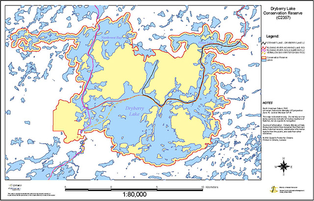
Enlarge regional setting of the Dryberry Lake conservation reserve map
Appendix C: Map overview of the Dryberry Lake conservation reserve (C2357)
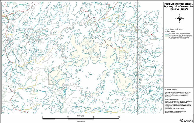
Enlarge overview of the Dryberry Lake conservation reserve map
Appendix D: Point Lake climbing route, Dryberry Lake conservation reserve (C2357)
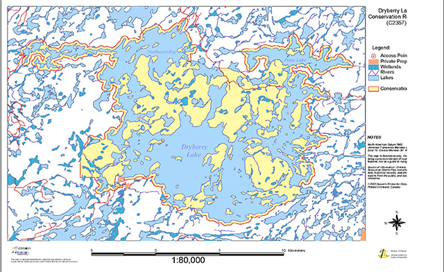
Enlarge Point Lake climbing route, Dryberry Lake conservation reserve map
Appendix E: Map of common canoe routes within the Dryberry Lake Conservation Reserve (C2357)
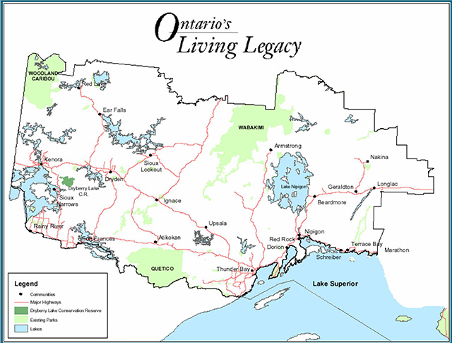
Enlarge common canoe routes within the Dryberry Lake Conservation Reserve (C2357) map
Appendix F: Definitions of geological terminology
| Term | Definition | Source |
|---|---|---|
| Archean | The earliest eon of Precambrian time, older than 2500 million years. | Blackburn, 2002 |
| Batholith | A very large body of intrusive rock, usually granite. | Kean, 1993 |
| Chattermarks | A series of chipped-out crescent shaped fractures on the surface of glacially scoured rocks. | Blackburn, 2002 |
| Foliation | Tectonically imposed planar structure in rocks defined by mineral layering and/or orientation. | Blackburn, 2002 |
| Gabbro | Mafic igneous intrusive rock composed of calcic feldspar and a mafic mineral, commonly pyroxene and/or hornblende. | Blackburn, 2002 |
| Glacial Striations | Scratches and scours, commonly parallel to each other, on rock surfaces that are derived by the abrasive action of rock fragments embedded in glacial ice as it moves over the surface. | Blackburn, 2002 |
| Gneiss | Coarsely crystalline rock in which a layering is defined by alternation of light and dark minerals and/or granular and platy minerals. | Blackburn, 2002 |
| Granite | Specific term applied to granitic rocks in which potassic feldspar exceeds sodic feldspar. Biotite is the common mafic mineral. | Blackburn, 2002 |
| Granitic | General term applied to intrusive igneous rocks with visibly distinct crystallinity that are quartz-bearing: includes granite, granodiorite, tonalite and quartz diorite. | Blackburn, 2002 |
| Granitoid | Commonly used in same sense as granitic. | Blackburn, 2002 |
| Granodiorite | Granitic rock with similar amounts of potassic and sodic feldspar, and commonly biotite as the mafic mineral component. | Blackburn, 2002 |
| Greenstone | General term for dark coloured volcanic rocks that have been metamorphosed to a characteristic dark green colour. | Blackburn, 2002 |
| Igneous Rock | Rock that has crystallized from molten material, known as magma. | Kean, 1993 |
| Intrusive Rock | Igneous rock that forms intrusions; as opposed to volcanic or extrusive rock which is erupted from a volcano. | Kean, 1993 |
| Mafic | Refers to igneous rocks with a high content of magnesium-rich minerals, commonly imparting a dark colour to the rock. | Blackburn, 2002 |
| Meta (prefix) | Implies metamorphism of the rock type to which it is applied, e.g. metasedimentary. | Blackburn, 2002 |
| Metamorphic Rock | A rock converted from pre-existing rock in the earth’s crust by changes in temperature and pressure or by chemical action of fluids. | Kean, 1993 |
| Rôches Moutonnée | Glacial landform in which an elongate rock knob has been smoothed and striated by glacial ice action on the up-ice side and fractured and plucked on the down-ice side, resembling the form of a sheep lying in a field. | Blackburn, 2002 |
| Sedimentary Rock | Rock formed by accumulation and cementing of loose sediment (e.g., sandstone), the deposition of chemical compounds held in solution in water (e.g., limestone), or by the accumulation of animal or plant debris (e.g., coal). | Kean, 1993 |
| Tonalite | Granitic rock with a predominance of sodic feldspar over potassic feldspar, with hornblende and/or biotite as mafic mineral component. | Blackburn, 2002 |
| Volcanic | Term applied to igneous rocks in which cooling and subsequent crystallization occurred at the earth’s surface. | Blackburn, 2002 |
Appendix G: Dryberry Lake conservation reserve (C2357) mineral potential
Ministry of Northern Development and Mines
Ministere du Developpement du Nord et des Mines
Ontario Geological Survey
104 - 810 Robertson Street
Kenora ON P9N 412
Tel: (807) 468-2926
November 01, 2002
RE: Dryberry Lake Conservation Reserve (C2357)
Dear Ms. Thomson,
The attached file was reviewed by Peter Hinz, Regional Land Use Geologist (A), NW Region.
The following files, reports or maps were reviewed to assess the mineral potential of this site. They included Open File Report 5769, Preliminary Geological Map 281 and OGS 1961 Airborne Magnetic Survey maps for 52F/05 (1169G) and 52F/12 (1170G).
The Dryberry Lake Conservation Reserve is underlain by granitic rocks and their metamorphosed equivalents of the Dryberry Batholith (Sanborne-Barrie, 1991). The northern portion consists of metamorphosed tonalite to monzogranite with minor mafic gneiss (metabasalt) and metasedimentary paragneiss (metagreywacke). The southern portion consists of unmetamorphosed granitoids of granodiorite, monzogranite, tonalite, monzonite and quartz diorite composition with minor granite pegmatite (See Figure 1). Both of these areas have low potential for economic mineralization (gold, base metal, PGE, etc.) however, these granite bodies are known to have potential for dimension stone as the Dryberry Batholith contains Nelson Granite Quarry in Docker Township.
The gabbroic rocks have potential to host Cu-Ni-PGE mineralization as shown by the Kenbridge Deposit (3.2 Mt @ 1.06% Ni and 0.54% Cu) located along strike in same rock type only 6 km to the ESE. The War Club Group has only recently been investigated due to new discoveries in 1990's in this same package of rocks in the Dryden area such as the Thunder Lake Deposit (3.78 Mt@ 7.02 gpt Au). The felsic and mafic volcanic rocks are historically the hosts for Au and/or Cu-Zn mineralization as shown by the Maybrun Mine (2.8 Mt @ 1.18% Cu and 2.49 gpt Au) located in the same rock assemblage 11 km to the SE. All of these boundary areas have undergone limited exploration is the past ten years however, with forestry activity, new road systems have made the area more accessible to further exploration.
The only recorded work done is this area was conducted by Falconbridge Limited in 1956 on the east side of War Club Lake (Kenora Assessment Files 52F/12SE B-2). Diamond drilling intersected pyritepyrrhotite iron formation and pyrrhotite-bearing gabbro but no assays were recorded. It should be noted that not all exploration work is necessarily filed for assessment.
No mining claims, assessment data, mineral deposit index or abandoned mines studies could be located within the area of the Dryberry Lake Conservation Reserve. While there are no known abandoned mine hazards within the immediate vicinity of the proposed site, the MNDM makes no representations as to the nature or safety of the site.
The MNDM recognizes the importance of the natural heritage values within the Dryberry Lake Conservation Reserve and acknowledge that mineral exploration will not be allowed within its boundaries. However, the MNR should be aware that the ground adjacent to, and surrounding the southern and eastern limits of this Conservation Reserve has significant potential to host mineralization. As such, the MNR should be aware that exploration work may occur adjacent to the Conservation Reserve in the future.
Yours truly,
Allen Raoul
Kenora District Geologist
cc: Peter Hinz, MNDM
Appendix H: The test of compatibility as defined by the conservation reserves policy (PL3.03.5)
Procedural guideline B - land uses - test of compatibility
The Conservation Reserve policy provides broad direction with regard to the permitted uses. The policy provides only an indication of the variety of uses that will be considered acceptable in conservation reserves. The only caution is that any new uses, and commercial activities associated with them, will be considered on a case by case basis, and, they must pass a test of compatibility to be acceptable.
What does a 'test of compatibility' mean?
An examination of this must start from the premise of why an area is set aside - specifically, its representative natural heritage values. Criteria are then identified to guide compatibility considerations. These criteria apply to the long term acceptability of both existing uses and new uses.
-
Conformity to SCI/RMP: SCI describe values for which an area has been set aside and the range of appropriate uses that will be permitted in the area. SCI may also speak to the acceptability of other new uses currently not occurring in the area.
The first test is:
do proposed new land uses and/or commercial activities conform to the direction of the SCI/RMP for the conservation reserve? Would the new use(s) depart from the spirit of appropriate indicator land uses in the SCI/RMP?
-
Impact Assessment: If the proposed use(s) pass test one it is important to determine their impact on the area before they are approved. This should include the following:
- impact on natural heritage values:
will the new use(s) impact any natural values in the area? If so how and to what degree? Is it tolerable?
- impact on cultural values:
will the new use(s) impact any historical or archaeological values in the area?
- impact on research activities:
will the new use(s) affect any research activities in the area?
- impact on current uses:
will the new use(s) have any negative impact on the array of current uses?
- impact on area administration:
will the new use(s) increase administrative costs and/or complexity?
(For example, the cost of area monitoring, security and enforcement). - impact of accommodating the use outside the conservation reserve:
Could the use(s) be accommodated as well or better outside the conservation reserve?
- impact on socio-economics of the area:
will the new use(s) affect the community(ies) surrounding the area in a positive or negative way?
(For example, will the new use make the area less remote thereby affecting a local tourism industry that is dependent on the area’s remoteness for its appeal?- Impact on area accessibility:
does the new use(s) give someone exclusive rights to the area or a portion of the area to the exclusion of other existing uses?
- Impact on area accessibility:
- impact on natural heritage values:
Appendix I: Documented fish species inhabiting the Dryberry and point lakes systems (OMNR, 1977; OMNR, 1960)
| Family | Scientific name | Common name |
|---|---|---|
| Catostomidae | Catostomus commersoni | White Sucker |
| Centrarchidae | Micropterus dolomieui | Smallmouth Bass |
| Centrarchidae | Ambloplites rupestris | Rock Bass |
| Cottidae | Cottus bairdi | Mottled Sculpin |
| Coregontidae | Coregonus artedii | Cisco |
| Coregontidae | Coregonus clupeaformis | Lake Whitefish |
| Cyprinidae | Notemigonus crysoleucas | Golder Shiner |
| Cyprinidae | Notropis atherinoides | Emerald Shiner |
| Cyprinidae | Notropis heterolepis | Blacknose Shiner |
| Cyprinidae | Notropis hudsonius | Spottail Shiner |
| Cyprinidae | Notropis volucellus | Mimic Shiner |
| Cyprinidae | Pimephales notatus | Bluntnose Minnow |
| Esocidae | Esox lucius | Northern Pike |
| Esocidae | Esox masquinongy | Muskellunge |
| Gadidae | Lota lota | Burbot |
| Percidae | Etheostoma exile | Iowa Darter |
| Percidae | Etheostoma nigrum | Johnny Darter |
| Percidae | Perca flavescens | Yellow Perch |
| Salmonidae | Salvelinus namaycush | Lake Trout |