Dutcher Lake Conservation Reserve Management Statement
This document provides policy direction for the protection, development and management of the Dutcher Lake Conservation Reserve and its resources.
Prepared with the assistance of:
Meteek & Company
Huntsville, Ontario
March, 2003
Approval statement
We are pleased to approve this Statement of Conservation Interest for Dutcher Lake Conservation Reserve (C87).
Dutcher Lake Conservation Reserve is located about 21 kilometres north-east of the Town of Parry Sound and about 10 kilometres south-east of the hamlet of McKellar in the Territorial District of Parry Sound. Most of the site is situated in the southeastern part of McKellar Township, but it also extends into the Township of Seguin (northern Christie and Monteith Wards) and the Township of Magnetawan (southwestern Spence Ward).
This 1,952 hectare conservation reserve was identified for protection during the Lands for Life planning process because it occupies one of the four upper watersheds of the Seguin River. In addition, it is a relatively remote area with a variety of biological and wildlife habitats in a mixture of rock barrens, hardwood forests and wetlands.
Dutcher Lake Conservation Reserve is one of 378 new protected areas approved through Ontario’s Living Legacy Land Use Strategy, aimed, in part, at completing Ontario’s system of parks and protected areas.
During the “Lands for Life” planning process, the public was widely consulted and provided valuable input into what became Ontario’s Living Legacy Land Use Strategy. During consultation related to the formal Public Lands Act (Ontario Regulation 805/94) regulation of the boundaries of this conservation reserve (in 1999 and 2000) a number of minor boundary changes were made to reduce resource management conflicts, and to ensure the boundaries reflected areas requiring protection. Comments received during consultation were generally supportive of the protection of this area. Stakeholders who provided comment during the earlier consultation for this site were subsequently consulted regarding the draft Statement of Conservation Interest and their comments were considered in the finalization of this document.
This Statement of Conservation Interest provides guidance for the management of the conservation reserve and provides the basis for the ongoing monitoring of activities. More detailed direction is not anticipated at this time. Should more complex resource management or conservation issues arise or significant facility development be considered, then a detailed Resource Management Plan will be prepared with full public consultation.
Dutcher Lake Conservation Reserve is managed under the direction of the District Manager and the Parry Sound Area Supervisor of the Ministry of Natural Resources, Parry Sound District.
Approved by:
R. Griffiths
District Manager
Parry Sound District
Approved by:
Ron Running
Regional Director
Southcentral Region
Figure 1: Location of Dutcher Lake Conservation Reserve
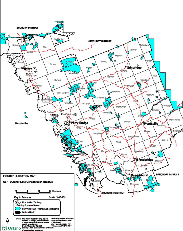
Enlarge Location of Dutcher Lake Conservation Reserve map
Figure 2: Site map – Dutcher Lake Conservation Reserve
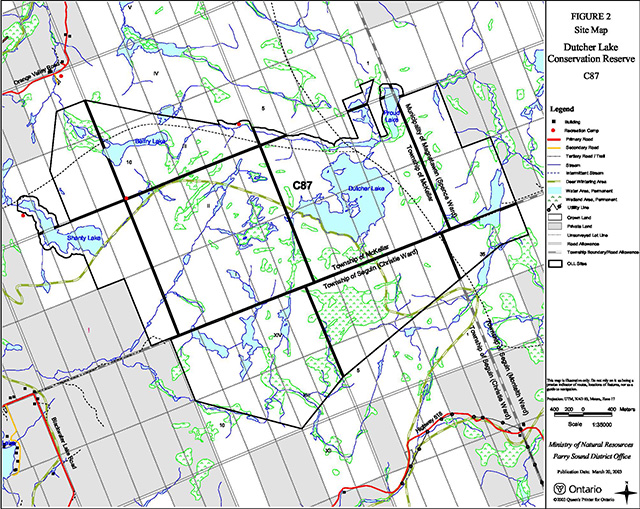
Enlarge Dutcher Lake Conservation Reserve site map
1.0 Introduction
Ontario’s Living Legacy, the result of an extensive planning process that began in early 1997, culminated in the approval in July 1999 of a Land Use Strategy that identifies the intended strategic direction for Crown land, including the completion of Ontario’s system of parks and protected areas. This process, which included extensive public consultation, resulted in the recommendation for regulation of 378 new protected areas, including Dutcher Lake Conservation Reserve (C87).
Dutcher Lake Conservation Reserve is located about 21 kilometres north-east of the Town of Parry Sound and about 10 kilometres south-east of the hamlet of McKellar in the Territorial District of Parry Sound. Most of the site is situated in the southeastern part of the Township of McKellar, but it also extends into the Township of Seguin (northern Christie and Monteith Wards) and the Township of Magnetawan (southwestern Spence Ward).
The conservation reserve, in Hill’s ecological Site District 5E -8, is important as a headwater area, containing one of four upper watershed areas of the Seguin River. It contains a variety of wildlife habitats in a relatively inaccessible setting of rock barrens, forests and wetlands. Its oak forest provides a mast crop that supports white-tailed deer (Odocoileus virginianus) and black bear (Ursus americanus) as well as other species of mammals and birds. The area is potential habitat for the prairie warbler (Dendroica discolor), rare in Ontario, and for the threatened eastern hognose snake (Heterodon platyrhinos).
While a reasonably large area in its own right, Dutcher Lake Conservation Reserve is close to two larger conservation reserves: Ahmic Forest and Rock Barrens Conservation Reserve, about 6 kilometres to the north; and Bear Lake Peatland Conservation Reserve, about 6 kilometres to the east. Together with the relatively undisturbed intervening lands, these areas provide travel corridors to allow relatively free passage of wildlife.
Conservation reserves are established under the authority of the Public Lands Act, Ontario Regulation 805/94. Dutcher Lake Conservation Reserve was established by Ontario Regulation 86/01, an amendment of the Public Lands Act, on April 6, 2001.
A Statement of Conservation Interest (SCI) is prepared under the authority of Procedural Guideline A – Resource Management Planning (PL. Procedure 3.03.05). The purpose of this SCI is to identify and describe the values of Dutcher Lake Conservation Reserve. The SCI also outlines the activities that currently occur within the conservation reserve and provides guidelines for the management of current and future activities in the context of protecting the natural, recreational and cultural values.
1.1 Background information:
| Name | Dutcher Lake Conservation Reserve (C87) |
|---|---|
| Site region/district | Georgian Bay 5E-8 |
| OMNR administrative region/district/area | Southcentral Region/Parry Sound District/Parry Sound Area |
| Total area (ha.) | 1,952 hectares |
| Regulation date | April 6, 2001 (O. Reg. 86/01) |
| First Nations | Robinson-Huron Treaty |
| OBM map sheets | 10 17 5900 50300, 10 17 5900 50350, 10 17 5950 50300, 10 17 5950 50350 |
| Topographic map | Orrville 31 E/5 |
| UTM co-ordinates | 17T 59670 503350 (Centroid) |
1.2 Representation
Earth science representation:
Bedrock
- Parry Sound Domain, Parry Sound Terrane in the northwestern part of the Proterozoic Central Gneiss Belt of the Grenville Province.
- Dominant rock types are intermediate gneiss derived from meta-leucodiorite with subordinate metagabbro xenoliths and younger granite pegmatite.
Surficial
- Bare bedrock with minor pockets and discontinuous areas of thin glacial drift (ground moraine), with areas ice-contact stratified drift and glaciolacustrine stratified drift, showing the influence by glacial scouring, followed by erosion and reworking by receding waters of post-glacial Lake Algonquin.
Life science representation:
The site has a diversity of landform and vegetation features including:
- Granite bedrock barrens with sparse forest cover;
- A variety of wetland types, including small pockets of “micro-wetlands” , larger graminoid/sedge meadows and several small fen/bog features;
- Pockets of deeper accumulated soils with immature forest stands, possibly of fire origin; and,
- An area of more mature forest with many large white pine (Pinus strobus) and yellow birch (Betula alleghaniensis).
Cultural resources representation:
Neither detailed cultural research nor inventory has been carried out for this conservation reserve. However, the presence of old large stumps indicates that this area was logged for white pine in mid to late 19th century. There is little other evidence of historic use or development. Recent regional evaluation (OMNR, 2003) shows that this conservation reserve contains areas that have a high potential for cultural heritage sites.
Recreational opportunities:
A recreational inventory report was prepared for this site based primarily on existing knowledge and data sources of MNR staff, and reflecting field observations made during the preparation of the life science report; a site visit was also made (Brown, 2002). Currently, it is used for hunting, fishing, snowmobiling and some all- terrain vehicle use.
1.3 Survey work
| Survey level | Earth science | Life science | Cultural | Recreational | Other |
|---|---|---|---|---|---|
| Reconnaissance | Duba & Frey, 2001 | Blythe & Assoc., 2002 | OMNR, 2003 | Brown, 2002 | None |
| Detailed | None | None | None | None | None |
| Requirement | None | Monitor the status/presence of significant species and associations. | Research to be encouraged | Monitor use impacts | None |
2.0 Values to be protected
The conservation reserve is located entirely within Hills’ (1959) ecological Site District 5E-8. Values include earth science, life science and recreational/aesthetic values, with an emphasis on the life sciences.
2.1 Earth science:
(Earth science information, unless otherwise noted, is taken from Duba & Frey, 2001)
Bedrock:
Dutcher Lake Conservation Reserve is a low relief area of numerous wetlands, interconnecting drainages, wetlands and bedrock barrens. The dominant rock type exposed is intermediate gneiss derived from meta - leucodiorite with subordinate metagabbro xenoliths and younger granite pegmatite of the Parry Sound Domain, Parry Sound Terrane in the Proterozoic Central Gneiss Belt of the Grenville Province (Duba & Frey, 2001).
The Grenville Province is the product of thrusting and imbrication of the earth’s crust to the northwest as it collided with a continental land mass to the southeast. The Grenville Orogeny, circa 1140 to 1070 million years ago, culminated more than 500 million years of crustal evolution. The eroded rocks of the products of these events are displayed in the complexly metamorphosed and deformed rocks of the region (Easton, 1992b).
The Parry Sound Terrane is one of the four lithotectonic terranes of the Central Gneiss Belt. The Parry Sound Domain is one of three structural domains of the Parry Sound Terrane. This geological environment is part of the modern organization of the complex products of the mid-Proterozoic orogenic events (Easton 1992a & b). As such, their representation in Dutcher Lake Conservation Reserve contributes to the conservation of the Grenville Province continental accretion theme (Davidson, 1981).
The geological features of the conservation reserve are of regional significance in the representation of metaplutonic components of the Parry Sound Domain, Parry Sound Terrane.
Surficial:
Dutcher Lake Conservation Reserve lies mostly in an area of relatively low relief with well-rounded bedrock hills, with numerous small lakes and wetlands with interconnecting drainage systems. The granite hills have been heavily influenced by glacial scouring, followed by erosion and reworking by the receding waters of post- glacial Lake Algonquin (Hoffman et al., 1962). The shallow (ground moraine) tills are a typical component of the Late Wisconsinan Stage of the Quaternary Era in southwestern Ontario, as are the accumulations of ice-contact stratified drift and glac iolacustrine stratified drift. More than half of the area is underlain by bedrock with only minor pockets of till. Surficial geology of the conservation reserve is locally significant.
2.2 Life science:
(Life science information, unless otherwise noted, is taken from Blythe & Associates, 2002)
The conservation reserve is located within Hills’ (1959) ecological Site District 5E-8. Life science significance is determined on the basis of the following criteria: representation, diversity, condition, ecological considerations and special features (Crins and Kor, 1998).
Representation:
Dutcher Lake Conservation Reserve encompasses a large area of forest and rock barrens habitat. Owing to its size, 1,952 hectares, the reserve contains a diversity of botanical and wildlife habitats. Throughout much of the conservation reserve, the topography features relatively flat exposures of granitic bedrock, including two similar landform types, “shallow till and rock ridges” and “rock ridges and shallow till” . (Chapman and Putnam, 1984) The surficial topography has also been heavily influenced by glacial scouring, followed by erosion and reworking by the receding waters of post-glacial Lake Algonquin. These factors, in combination with logging activities of the late 19th and early 20th centuries and the influence of one, or more, large post -logging forest fires, has created the present day rock barrens environment of the conservation reserve.
These rock barrens support a sparse forest of stunted red oak (Quercus rubra), red maple (Acer rubrum) and a few scattered white pine (Pinus strobus). The wide spacing between the trees and the predominant ground cover of poverty oat grass (Danthonia spicata) and common hairgrass (Deschampsia flexuosa) gives this landscape a savannah-like quality. These two species of grass in combination with bracken fern (Pteridium aquilinum), spreading dogbane (Apocynum androsaemifolium) and low sweet blueberry (Vaccinium angustifolium) comprise the bulk of the herbaceous plants, which can survive in this harsh nutrient poor environment. Also prevalent are numerous species of lichens such as Stereocaulon tomentosum, Cladina stellaris and Cladina rangiferina. The conservation reserve shows evidence of a past fire-dependent ecosystem and evolution towards a similar fire-dependent regime.
Typical of this landscape is invariably a very shallow to a non-existent covering of glacial till soils of the Monteagle Gravelly Sand Complex (Hoffman et al., 1962) with frequently occurring shallow depressions in the bedrock. The shallow pools formed in these depressions have resulted in the formation of micro -wetlands — usually less than 100 m² — which dot the landscape. These small wetlands produce a thin layer of organic soils over bedrock and sustain an assemblage of hydrophytic species. These are the most numerous of the wetlands found in the conservation reserve. Similar to these small micro-wetlands are the much larger beaver-dependent graminoid/sedge meadows. The dominant species in both of these features are identical: Canada bluejoint grass (Calamagrostis canadensis), woolgrass (Scirpus cyperinus) and nodding sedge (Carex gynandra). In addition, there were several small fen/bog features associated with perched water tables, and to some extent, associated with the activity of beavers. The largest of these, located on Proud Lake, contained typical bog/fen associates, specifically pitcher plant (Sarracenia purpurea), sundew (Drosera spp.), and tawny cotton grass (Eriophorum virginicum).
In other low lying areas, where the eroded soils from the original pre-logging soil mantle have accumulated, there are relatively deep deposits of sandy soil. These areas tend to be focused around the east shore of Dutcher Lake and in valleys formed by several faults in the Earth’s crust. The forests associated with these areas are relatively immature and sustain stands of white birch (Betula papyrifera), largetooth aspen (Populus grandidentata), balsam fir (Abies balsamea), some white spruce (Picea glauca) and white pine (Pinus strobus). The presence and condition of these shade intolerant hardwood species would indicate recent disturbance by fire. The forest understory associated with these deep soil pockets includes a greater diversity of herbaceous plants, such as: wild sarsaparilla (Aralia nudicaulis), starflower (Trientalis borealis), long-awned wood grass (Brachyelytrum erectum) and intermediate wood fern (Dryopteris intermedia).
A more mature forest was observed southwest of Belfry Lake in a fault line valley, which forms a series of watercourses and beaver ponds. The north valley slope of the fault line has many large mature white pine and yellow birch (Betula alleghaniensis). The valley floor supports a forest of shade intolerant species such as white birch — indicative of a more recent fire event.
The area offers a suitable range of habitats for wildlife species typical to the region, such as: moose (Alces alces), coyote (Canis latrans), eastern gray wolf (Canis lupus lycaon), beaver (Castor canadensis) and racoon (Procyon lotor).
Condition:
Most of this area shows little evidence of logging, with the exception of some large, desiccated and charred white pine stumps, remnants of a former white pine forest, that may indicate mid-19th century harvest activity. There were a few large white pine stumps south of Belfry Lake, probably cut about 20 to 30 years ago. The former skid roads have been kept open by local all-terrain vehicle and snowmobile users.
While there is no access to the conservation reserve on public roads, the majority of the conservation reserve’s boundary line is bordered by Crown land where access is possible from the Orange Valley Road to the north and Highway 518 to the south. In some seasons, access is also possible from the Muskrat Valley Road to the east, though private property rights in Lot 33, Concession 1 of Spence Township must be respected.
There are two authorized snowmobile trails touching or crossing through the conservation reserve. The OFSC Trans Ontario Connector trail # C101 runs in a north-south direction along the east side of Dutcher Lake. This trail is joined by the westerly extension of local snowmobile club trail # 804 northeast of the reserve. This secondary trail enters the conservation reserve from the west and skirts the north shore of Belfry Lake.
Snowmobile trails, all-terrain vehicle trails and foot paths in the conservation reserve appear to be maintained periodically as evidenced by chainsaw cuts observed on fallen trees and brush on these trails.
Diversity:
This headwaters area combines extensive areas of stunted red oak savannah-like barrens, along with a variety of wetland types from micro-wetlands, much larger beaver-dependent graminoid/sedge meadows, and several small fen/bog features associated with perched water tables.
In low lying areas where the eroded soils from the original pre-logging soil mantle have accumulated, there are relatively deep deposits of sandy soil with relatively immature stands of: white birch, largetooth aspen, balsam fir, some white spruce and white pine. A more mature forest with many large mature white pine and yellow birch occurs southwest of Belfry Lake in a fault line valley.
Ecological considerations
This conservation reserve encompasses most of a headwaters area, part of the upper watershed of the Seguin River.
The dominance of the red oak savannah-like forest and its periodic abundance of acorn mast crops provide an important source of food for white-tailed deer, black bear and 28 other species of wildlife that eat acorns in central Ontario. The presence of this relatively uncommon forest type, and the mast crop it produces, is critical for the maintenance of local wildlife populations, including populations well beyond the boundaries of the conservation reserve, as birds and large mammals will travel overland to feed on acorns in late summer and autumn.
Dutcher Lake Conservation Reserve is close to two larger conservation reserves: Ahmic Forest and Rock Barrens Conservation Reserve, about 6 kilometres to the north; and Bear Lake Peatland Conservation Reserve, about 6 kilometres to the east. Together with the relatively undisturbed intervening lands, these areas provide travel corridors to allow relatively free passage of wildlife.
Rock barrens habitats, with an abundance of water, scattered shrubs and stunted trees, are favoured as nesting habitats by a large number of bird species. Of particular note, the prairie warbler, a rare species in Ontario, prefers habitat of this type and is known to nest in the coastal barrens to the west of the conservation reserve.
The mixture of rock barrens, hardwood forests and assorted wetlands, provides a large contiguous area of suitable habitat for several herpetofaunal species including the threatened eastern hognose snake (Heterodon platyrhi nos). Although no specimens of this snake were observed during the late summer survey of 2002, several occurrences of eastern hognose snakes have been reported to the west of the conservation reserve along the Blackwater Lake Road.
Special features:
The Dutcher Lake Conservation Reserve encompasses most of an upper watershed system, which flows through Belfry Lake into the Manitouwabing River and thence into the Seguin River. This is important as a headwater area, being one of four upper watershed areas of the Seguin River.
Evidence of suitable habitat would suggest that this conservation reserve has high potential to support a population of the provincially and nationally threatened eastern hognose snake.
2.3 Cultural values:
While no specific cultural studies or inventories have been undertaken within the conservation reserve, and no major cultural resource values have been evaluated or identified to date, there is physical evidence of early (19th century) logging in areas of this conservation reserve (Blythe & Associates, 2002). Recent regional evaluation (OMNR, 2003) shows that this conservation reserve contains areas that have a high potential for cultural heritage sites.
2.4 Recreational/aesthetic values:
Hunting and fishing appear to be the primary recreational activities that have traditionally occurred within the conservation reserve’s boundaries.
The conservation reserve supports the usual populations of large and small game. Most hunting activity within the site is focused on white-tailed deer (Odocoileus virginianus), moose, and to a much lesser extent, black bear (Ursus americanus). There are two recreation camps within the conservation reserve and an additional three are located on adjacent Crown land.
Sport fishing also occurs as a secondary recreational activity. Two of the four lakes within the conservation reserve (Dutcher and Shanty) are known to support recreational fishing (See Section 3.3). Ice fishing is a significant local activity on Dutcher Lake, which is also used by a number of fly-in outfitters as a “remote” lake.
Snowmobiling is a significant recreational activity which takes place within the reserve as an organized sport. As previously noted, there are two snowmobile trails that traverse the site. The OFSC Trans Ontario connector trail # C101 runs in a north-south direction along the east side of Dutcher Lake. This trail is joined by the westerly extension of local snowmobile club trail # 804 northeast of the reserve. This secondary trail enters the conservation reserve from the west and skirts the north shore of Belfry Lake.
There is some evidence of all-terrain vehicle use of the snowmobile trails but little evidence that other all- terrain vehicle trails have developed within the conservation reserve. It is expected that there is some use of all-terrain vehicles associated with hunting activity. Owing to the durable nature of the rock barren terrain, little damage is evident.
The biophysical attributes of the conservation reserve lend themselves to nature related activities such as bird-watching, hiking, cross-country skiing and snowshoeing, but the degree of use for these activities is, for the most part, unknown since they have a relatively low impact on the landscape, and tend not to be represented by organized user-group associations.
3.0 Management guidelines
3.1 Land tenure:
Background:
Dutcher Lake Conservation Reserve comprises 1,952 hectares of Crown land. It is generally surrounded by Crown land, but private lands abut its boundaries on the east and west sides. Concession road allowances which cross or about the conservation reserve remain under the authority of the municipality wherein they lie, and are not included as part of the conservation reserve. There is no intent to acquire adjacent private lands for addition to the conservation reserve.
Most of the conservation reserve lies within Bear Management Area PS-49-08. The small portion of the reserve in Monteith Township is within Bear Management Area PS-49-09. Four assigned Bait Fish Blocks, (Monteith 1, Christie 2, McKellar 3, and Spence 4) extend into the conservation reserve. There are four registered traplines that overlap the conservation reserve (PS-88, PS-90, PS-132 and PS-181). There are two authorized recreation camps within the boundaries of the conservation reserve, and three close to, but outside of its boundaries.
Two developed snowmobile trails cross the conservation reserve. Trail C101 is a Trans Ontario Provincial Trail; the other, #804 is a feeder trail. Both are maintained by the Dun-Ahmic Snow Riders Club.
Of particular note is a longstanding Licence of Occupation (dating back to 1887) for flooding rights in Lots 5 to 11, Concession 3 and Lots 10 and 11, Concession 4, in McKellar Township. This Licence of Occupation surrounds Belfry Lake through which this headwaters area drains to the Manitouwabing River, and then into the Seguin River. Furthermore, there is 1914 legislation, “An Act respecting the Town of Parry Sound” , which grants flooding rights on the Seguin River to the Town of Parry Sound. This legislation is still in effect and gives the right to flood other waterbodies within this conservation reserve (e.g. Dutcher Lake).
Guideline:
The sale of Crown lands within the conservation reserve is not permitted. While the Ontario’s Living Legacy Land Use Strategy provides minor flexibility in this policy, there are no sites adjacent to this conservation reserve which would meet the stipulated criteria.
There are no plans by the MNR to acquire private lands to add to the conservation reserve.
The commercial bear hunting service associated with the current Bear Management Area is allowed to continue. Fur harvest is permitted to continue in the registered trapline areas. The Bait Fish Blocks are currently assigned, and are permitted to continue.
The existing recreation camps within the conservation reserve are permitted to continue. They may be eligible for “enhanced” tenure, but are not eligible for purchase of land. (See Appendix 4)
New recreation camps are not permitted.
The pre-existing flooding rights within the conservation reserve area are recognized as a continuing right.
3.2 Development:
Background:
The conservation reserve is located west of the Nipissing Road, south of the Orange Valley Road and north of Hwy. 518. There is no public road access into the conservation reserve.
There are no Crown owned buildings or other facilities within the conservation reserve; there may be an existing trapper’s cabin. Two snowmobile trails pass through the conservation reserve. The OFSC Trans Ontario Connector trail # C101 runs in a north-south direction along the east side of Dutcher Lake. This trail is joined by the westerly extension of local snowmobile club trail # 804 northeast of the reserve. This secondary trail enters the conservation reserve from the west and skirts the north shore of Belfry Lake.
Guideline:
New roads for resource extraction and/or private use will not be permitted, nor will additions to existing roads, or up grading of existing roads be permitted. There is no intention to develop roads outside of the conservation reserve to improve access to this site.
No mineral exploration is permitted within this conservation reserve. This policy decision is based on a commitment made by the Ministry of Natural Resources and the Ministry of Northern Development and Mines in March 2002. This policy direction replaces that identified in the 1999 Ontario’s Living Legacy Land Use Strategy (OMNR 1999), which stated that controlled mineral exploration would be permitted in new conservation reserves which were identified as having provincially significant mineral potential.
In general, existing authorized recreational trails may be permitted to continue in conservation reserves as long as they do not impair the natural features and values for which the area is identified and as long as there are no significant environmental impacts. Accordingly, the two authorized snowmobile trails continue to be authorized, but their use will be monitored to ensure that conservation reserve values are not being adversely impacted. Additional recreational trails are not encouraged, but may be considered on a case by case basis. Public consultation will be an important part of the consideration of any new trails, and they would also be required to comply with Procedural Guideline B – Land Uses – Test of Compatibility (Appendix 1).
The pre-existing legislation and Licence of Occupation (See Section 3.1) affecting the conservation reserve gives the licencees a grandfathered right to control the water levels within the Seguin watershed. If the time comes that these rights are exercised, MNR will work with the Town of Parry Sound to ensure that any works are carried out so as to protect site values to the extent feasible.
While there is no intent at present to provide or permit any new development in this conservation reserve that would require lighting, should this be considered at some point in the future the MNR will not allow unnecessary, undirected light pollution. This commitment recognizes the wilderness values provided by a pristine night sky.
3.3 Recreational activities:
Background:
Existing recreational uses include hunting, snowmobiling and some all-terrain vehicle use. Most hunting activity in the conservation reserve focuses on white-tailed deer, moose and black bear. There are two authorized recreation camps within the boundaries of the conservation reserve, and three close to, but outside of its boundaries. Other hunting use originates locally.
There are four lakes within the conservation reserve (Dutcher, Shanty, Belfry and Proud). Two of them are known to support recreational fishing: Dutcher Lake contains lake whitefish (Coregonus clupeaformis), smallmouth bass (Micropterus dolomieui) and Cisco (Coregonus artedii); Shanty Lake contains largemouth bass (Micropterus salmoides). Ice fishing is a significant local activity on Dutcher Lake, and it is also used by a number of fly-in outfitters as a “remote” lake.
Two authorized recreational trails cross the conservation reserve (See Section 3.3). In addition to snowmobiling, some all-terrain vehicle use occurs on those trails. There may also be unauthorized all -terrain vehicle trails used in association with hunting activity.
There is little evidence of the use of the conservation reserve by hikers, birdwatchers, canoeists, mountain bikers, skiers, or snowshoers.
Guideline:
Hunting and fishing are permitted to continue within the conservation reserve.
Recreational use such as hiking, wildlife viewing, snowshoeing, and cross-country skiing, while currently very limited in extent and therefore not managed, will be allowed to occur in the conservation reserve.
The existing authorized snowmobile trails will continue to be authorized, Off-trail use of snowmobiles and all- terrain vehicles is only permitted for the direct retrieval of game. Trail and off-trail use will be monitored to ensure that the conservation reserve values are not being adversely impacted.
New recreational trails or changes to the existing routes are not permitted without prior MNR authorization. New trails are not encouraged, but, may be considered on a case by case basis provided they meet the Procedural Guideline B - Land Uses - Test of Compatibility (Appendix 1) and the MNR’s Environmental Assessment Act requirements.
The use of pre-existing unauthorized recreational trails, and any increase in use of all -terrain vehicles, will be monitored to ensure that conservation reserve values are not being adversely impacted. Depending on the results of monitoring, some trails may need to be redirected from sensitive areas or eliminated completely. Otherwise, there is no intent to mark or upgrade such trails
New recreational activities will be considered on a case by case basis provided they are consistent with maintaining the values of the conservation reserve and comply with Procedural Guideline B - Land Uses - Test of Compatibility (Appendix 1). Emphasis will be placed on activities that have a low impact on the environment of the conservation reserve.
3.4 Commercial activities:
Background:
There has been no recent commercial forest harvesting or mining activity within the conservation reserve.
There are currently four registered traplines covering this conservation reserve. The guiding of non -resident bear hunters is authorized through the Bear Management Areas, and bait fish harvesting is authorized through Bait Fish Block licences within the conservation reserve.
Guideline:
Fur harvesting, bear hunting services and bait fish harvesting operations are allowed to continue within the conservation reserve.
Mineral exploration is not allowed in this conservation reserve, as discussed in Section 3.2.
Conservation reserve regulations do not permit mining, commercial forest harvesting, hydroelectric power development, the extraction of aggregate and peat or other industrial uses (Public Lands Act, Ontario Regulation 805/94). Other new commercial activities must meet the requirements of Procedural Guideline B (see Appendix 1).
The pre-existing flooding rights (See Section 3.1) in the conservation reserve give the licencees a grandfathered right to control the water levels within their licence area. Therefore, while hydroelectric power generation is generally not permitted in conservation reserves, the grandfathered flooding rights result in a potential for such development in this particular conservation reserve. Research and studies focussing on assessing the potential for such development and its potential impact on conservation reserve values and headwater characteristics will be encouraged, with a view to developing mitigating measures if the time comes that these rights are exercised.
3.5 Aboriginal interests:
Background:
This site is located within the area of the Robinson – Huron Treaty of 1850, and as such the general area of this conservation reserve is known to be of interest to various First Nations.
Guideline:
The regulation and management of this conservation reserve will not impede the exercise of existing aboriginal or treaty rights . These rights include hunting, fishing, fur harvesting, gathering of plants for a variety of purposes, and the use of ceremonial sites. It is recognized that the manner in which they were carried out in the past, but has evolved over time with changes in technology.
While there are no existing First Nation land claims that extend to this site, it is recognized that at some point in the future there is a possibility of a land claim in this area. If such a land claim is determined to be valid, the Conservation Reserve designation is not irreversible and does not preclude consideration of these lands in the settlement of a claim.
3.6 Natural resource stewardship:
Vegetation management for specific purposes (other than historic logging) is not known to have occurred in the past. Wildlife and fisheries management has been occurring according to the prevailing policies and legislation.
The emphasis will be on ensuring that the natural values of the conservation reserve are not negatively affected by current and future activities. Therefore, applications for new specific uses will be carefully studied and reviewed. Necessary studies may be undertaken by proponents, the Ministry, and/or partner organizations.
Guideline – vegetation:
The nature of the bedrock topography with its shallow coverings of glacial till, the logging activities of the late 19th and early 20th centuries and the influence of one, or more, large post-logging forest fires, have created the present day rock barrens environment of the conservation reserve. The general lack of soil, the exposed bedrock barrens, and the dominance of the red oak savannah-like habitat, make this conservation reserve a good example of a fire-dependent ecosystem.
The intent of this site is to allow the existing vegetation communities to evolve naturally. The Ministry will continue to monitor for the status/presence of significant species and associations.
The OMNR recognizes fire as an essential process fundamental to the ecological integrity of this conservation reserve. In accordance with existing conservation reserve policy and the Forest Management Strategy for Ontario, forest fire protection will endeavour to use “light on the land” techniques, which do not unduly disturb the landscape, in this conservation res erve. Examples of light on the land techniques may include limiting the use of heavy equipment, and limiting the number of trees felled during fire response efforts. Input from the local MNR Area Supervisor would be solicited if a forest fire threatens the area. Opportunities for prescribed burning to achieve resource management objectives may be considered. Plans for any prescribed burning will be developed in accordance with the OMNR Prescribed Burn Planning Manual.
Programs may be developed to control forest insects and diseases in the conservation reserve where these threaten significant values in or adjacent to the site. Where insects or disease threaten significant values, in or adjacent to the site, control will be directed as narrowly as possible to the specific insect or disease. Biological control will be used wherever possible. In all cases, regard shall be had for Procedural Guideline B (see Appendix 1).
Guideline – wildlife and fisheries:
Hunting and fishing within Dutcher Lake Conservation Reserve will be guided by the relevant Ontario hunting and fishing regulations. Fur harvesting and bait fish harvesting will be managed through the maintenance of the current licensing system.
The Ministry will monitor the impacts of activities of snowmobile trails and the increasing use of all-terrain vehicles on the natural values of the conservation reserve.
3.7 Cultural resource stewardship:
Background:
There is evidence of early logging throughout this conservation reserve. However, no specific studies or inventories have been undertaken within the site, and no specific significant cultural resource values have been evaluated or identified to date. Recent regional evaluation (OMNR, 2003) shows that this conservation reserve contains areas that have a high potential for cultural heritage sites.
Guideline:
Should the MNR consider either carrying out or permitting new structural development, significant clearing of vegetation or altering of land within this conservation reserve, the MNR will adhere to the cultural heritage resource screening process as is identified in its Memorandum of Understanding (MOU) with the Ministry of Tourism, Culture and Recreation (MTCR). While the purpose of this MOU is to provide a process to identify and protect cultural heritage resources when the MNR is reviewing work permits or disposing of Crown rights under the authority of the Public Lands Act, Ontario Regulation 805/94, the considerations and criteria would also enable the MNR to identify high potential cultural heritage areas for other purposes within conservation reserves. If the screening process indicates that the site of a proposed activity is within an area of high cultural heritage potential, the MNR will consult with the MTCR to determine the appropriate cultural heritage assessment requirements and will undertake a preliminary archaeological assessment if appropriate.
Interested partners will be encouraged to undertake inventories, studies, and research to document the First Nations, resource harvest/management and recreation history in the area. The MNR will discuss the appropriateness of archaeological assessment with local First Nations and the Ministry of Tourism, Culture and Recreation.
3.8 Client services:
Background:
Access to the conservation reserve has generally been confined to traditional uses for the current commercial and recreational activities. There are no Crown facilities or services developed on or adjacent to the conservation reserve. The information fact sheet for this conservation reserve is currently available to the public through the Parry Sound District Office, or via the Internet at www.ontarioslivinglegacy.com [link is inactive].
Guideline:
The focus will remain on low key information and self-interpretation of conservation reserve values and features. Consideration will be given to the preparation of an information brochure (with map) to highlight the features for which the area was identified and appropriate uses to ensure the protection of those features.
Consideration will be given to the strategic location of identity signs where the authorized snowmobile trails cross the conservation reserve boundaries, and where other trails approach or cross the conservation reserve boundary. There are no other plans for structural development within this conservation reserve.
3.9 Research:
Background:
Research to date has included a number of reconnaissance surveys to document earth science, life science and recreation values.
Guideline:
Research focussing on the assessment of use/activity impacts on sensitive species and habitats will be encouraged. Research and studies that examine the potential impact of the exercising of grandfathered flooding rights, and that explore mitigating measures, will also be encouraged.
All research will be carried out in a non-destructive manner. Research proposals must follow Procedural Guideline C – Research Activities in Conservation Reserves (Appendix 3).
3.10 Marketing:
Background:
There has been no marketing of this conservation reserve to date. Promotion and information about this site has been primarily through the Ontario’s Living Legacy planning process and recent MNR Parry Sound District public consultation regarding the boundaries of this site.
Guideline:
Marketing activities of this conservation reserve will be kept to a minimum.
4.0 Implementation
Administrative responsibility for this conservation reserve belongs to the Parry Sound Area Office of the Parry Sound District of the Ministry of Natural Resources. The Area Office will continue to have the custodial care of Dutcher Lake Conservation Reserve. Emphasis will be placed on awareness information highlighting reserve values, and monitoring and managing the current approved uses.
Priorities will include:
- Ensure compliance to prescribed management policies of the approved SCI/GPS location of existing trails and classify their status and condition;
- Monitor and evaluate recreational and commercial use levels and impacts;
- Encourage research and studies that examine the potential impact of the exercising of grandfathered flooding rights and that explore mitigating measures;
- Encourage further inventory and research of the significant life science resources of the conservation reserve;
- Encourage research about use/activity impacts on wildlife species and habitats;
- Support cooperative ongoing education of resource users with respect to resource and land stewardship values, in order to maintain the ecological integrity of the site and to provide long term recreational opportunities; and
- Provide client services (e.g. brochure or fact sheet) at nearby MNR offices.
5.0 Review and revision of the Statement of Conservation Interest
This Statement of Conservation Interest will be amended through a standard process of minor and major amendments. Minor amendments will be processed in a relatively informal manner and will require the approval of the Area Supervisor. These amendments will deal with uses and activities that do not affect any of the policies in this SCI (e.g. new uses and/or activities that are consistent with existing permitted uses).
Uses and/or activities that were not anticipated in the approved SCI and which may have an impact on the values of the reserve will require a major amendment. This will include an opportunity for public comment and input, will require the approval of the District Manager and Regional Director.
6.0 References
Blythe, C. and Associates. 2002. Natural Heritage Area – Life Science Checksheet Dutcher Lake Conservation Reserve. OMNR, Parry Sound.
Brown, B. 2002 Recreation Resource Inventory Report. Dutcher Lake Conservation Reserve. OMNR Parry Sound.
Brunton, D. F. 1992. Life Science Areas of Natural and Scientific Interest in Site District 5E-8. OMNR, Algonquin Region, Huntsville.
Chapman, L. J. 1975. The Physiography of the Georgian Bay-Ottawa Valley Area of Southern Ontario. Ontario Division of Mines, GR 128, 35p. Accompanied by Map 2228, scale 1 inch to 4 miles or 1:253,440.
Chapman, L. J. and Putman, D. F. 1984. Ontario Geological Survey, Special Volume 2. The Physiography of Southern Ontario. Ontario Ministry of Natural Resources
Chapman, L. J. and Putman, D. F. 1984. Ontario Geological Survey, Special Volume 2, The Physiography of Southern Ontario, Third Edition. OMNR.
Crins, W. J. and Kor, P. S. G. 1998. Natural Heritage Gap Analysis Methodologies Used by the Ontario Ministry of Natural Resources. Unpublished Paper. Peterborough: OMNR.
Davidson, R. J. 1981. A framework for the conservation of Ontario’s earth science features. Ontario Ministry of Natural Resources, Toronto, 262 p.
Duba, D. and Frey, E. D. 2001. C99 Dutcher Lake Conservation Reserve. Earth Science Report, OMNR Peterborough.
Easton, R. M. 1992a. The Grenville Province and the Proterozoic history of central and southern Ontario; in Geology of Ontario, Ontario Geological Survey, Special Volume. 4, Part 2, p.715-904.
Easton, R. M. 1992b. Tectonic evolution of Ontario. Part 3: Mesoproterozoic evolution of the southeast margin of Laurentia; in Geology of Ontario, Ontario Geological Survey, Special Volume 4, Part 2, p.1302-1314.
Hills, G. A. 1959. A Ready Reference to the Description of the Land of Ontario and its Productivity. Ont. Dept. of Lands and Forests, Division of Research, Maple, Ontario.
Hoffman, D. W., Wicklund R. E. and Richards, N. R . 1962. Soil Survey of Parry Sound District. Report No. 31 of the Ontario Soil Survey. Research Branch, Canadian Department of Agriculture and the Ontario Agricultural College.
Kor, P. S. G. and Delorme, R. J. 1989. Quaternary Geology of the Magnetawan Area, Southern Ontario: Ontario Geological Survey, Preliminary Map P. 3134, Scale 1:50,000
Noble, T. W 1983. Biophysiographic Analysis, Site Region 5E, Algonquin Region, Ministry of Natural Resources. Algonquin Region, Huntsville.
Ontario Ministry of Natural Resources. 1999. Ontario’s Living Legacy: Land Use Strategy. Queen’s Printer for Ontario.
Ontario Ministry of Natural Resources. 2003. Cultural Heritage Registered Site Reserves and Areas of High Potential, Parry Sound District, Scale 1:150000.
Appendices
Appendix 1 Procedural Guideline B – land uses – test of compatibility (PL Procedure 3.03.05)
The conservation reserve policy provides broad direction with regard to the permitted uses. The policy provides only an indication of the variety of uses that will be considered acceptable in conservation reserves. The only caution is that “any new uses, and commercial activities associated with them, will be considered on a case by case basis, and, they must pass a test of compatibility to be acceptable.” What does a ’test of compatibility’ mean?
An examination of this must start from the premise of why an area is set aside – specifically, its representative natural heritage values. Criteria are then identified to guide compatibility considerations. These criteria apply to the long -term acceptability of both existing uses and new uses.
-
Conformity to SCI/RMP: SCI describe values for which an area has been set aside and the range of appropriate uses that will be permitted in the area. SCI may also speak to the acceptability of other ’new’ uses currently not occurring in the area.
The first ’test’ is: “do proposed new land uses and/or commercial activities conform to the direction of the SCI/RMP for the conservation reserve? Would the new use(s) depart from the spirit of appropriate indicator land uses in the SCI/RMP?”
- Impact Assessment: If the proposed use(s) pass test 1 it is important to determine their impact on the area before they are approved. This should include the following:
- Impact on natural heritage values: “will the new use(s) impact any natural values in the area? If so how and to what degree? Is it tolerable?”
- Impact on cultural values: “will the new use(s) impact an historical or archaeological values in the area?”
- Impact on research activities: “will the new use(s) affect research activities in the area?”
- Impact on current uses: “will the new use(s) have any negative impact on the array of current uses?”
- Impact on area administration: “will the new use(s) increase administrative costs and/or complexity?” (For example, the cost of area monitoring, security and enforcement).
- Impact on accommodating the use outside the conservation reserve: “Could the use(s) be accommodated as well or better outside the conservation reserve?”
- Impact on socio-economics of the area: “will the new use(s) affect the community(ies) surrounding the area in a positive or negative way?” (For example, will the new use make an area less remote thereby affecting a local tourism industry that is dependent on the area’s remoteness for its appeal?”
- Impact on area accessibility: “does the new use(s) give someone exclusive rights to the area or a portion of the area to the exclusion of other existing uses?”
The following table (Appendix 2) provides a guide of indicator uses for the consideration of uses that may be permitted within conservation reserves. For any specific conservation reserve that test of compatibility should be applied to determine which specific uses are acceptable.
Appendix 2 Indicator uses for conservation reserves: generic and specific
| Activities | Generic policy-existing | Generic policy-new | Specific application in Dutcher Lake Conservation Reserve |
|---|---|---|---|
| Sport fishing | Yes | Yes | Yes |
| Sport hunting | Yes | Yes | Yes |
| Food gathering | Yes | Yes | YesA |
| Facility infrastructure | Maybe | Maybe | Maybe |
| Non-trail snowmobiling | No1 | No1 | No1 |
| Non-trail all -terrain vehicle use | No1 | No1 | No1 |
| Rock climbing/caving | Maybe | Maybe | N/A |
| Canoeing/kayaking | Yes | Yes | Yes |
| Motorized boating | Yes | Yes | Yes |
| Picnicking | Yes | Yes | Yes |
| Camping | Maybe | Maybe | Yes |
| Trails: Hiking | Yes | Maybe | MaybeB |
| X-country skiing | Yes | Maybe | MaybeB |
| Cycling | Yes | Maybe | MaybeB |
| Horse riding | Yes | Maybe | MaybeB |
| Snowmobiling | Yes | Maybe | MaybeB |
| All-Terrain Vehicles | Yes | Maybe | MaybeB |
Science, education & heritage appreciation
| Activities | Generic policy-existing | Generic policy-new | Specific application in Dutcher Lake Conservation Reserve |
|---|---|---|---|
| Research | Yes | Yes | Yes |
| General walking | Yes | Yes | Yes |
| Photography & Painting | Yes | Yes | Yes |
| Wildlife viewing | Yes | Yes | Yes |
| Outdoor Education/Interpretation | Yes | Yes | Yes |
| Collecting | No | Maybe2 | Maybe2 |
Commercial activities
| Activities | Generic policy-existing | Generic policy-new | Specific application in Dutcher Lake Conservation Reserve |
|---|---|---|---|
| Food harvesting | Maybe | Maybe | No |
| Fishing | Maybe | Maybe | No |
| Baitfish harvesting | Yes | Maybe | Yes3 |
| Fur harvesting | Yes | Maybe | Yes3 |
| Trap cabins | Yes | No | MaybeC |
| Resort – outpost camp | Yes | No | NoC |
| Outfitting – bear management | Yes | No | Yes3 |
| Wild rice harvesting | Yes | Maybe | N/A |
Resource management
| Activities | Generic policy-existing | Generic policy-new | Specific application in Dutcher Lake Conservation Reserve |
|---|---|---|---|
| Inventory monitoring | Yes | Yes | Yes |
| Featured species management | Maybe | Maybe | Maybe |
| Natural systems management | Maybe | Maybe | Maybe |
Industrial activities
| Activities | Generic policy-existing | Generic policy-new | Specific application in Dutcher Lake Conservation Reserve |
|---|---|---|---|
| Timber harvesting | No | No | No |
| Mineral exploration | No | No | No |
| Mining | No | No | No |
| Hydro generation | No | No | NoE |
| Energy transmission corridors | Yes | No4 | No4 |
| Communications corridors | Yes | No4 | No4 |
| Public transportation corridors | Yes | No4 | Maybe4 |
| Resource access roads | Maybe | No | No |
| Private access roads | Maybe | No5 | No5 |
Other activities
| Activities | Generic policy-existing | Generic policy-new | Specific application in Dutcher Lake Conservation Reserve |
|---|---|---|---|
| Land Disposition | Maybe6 | No6 | No6 |
| Recreation Camps | YesC | No | YesC,D |
Notes:
On generic policy application in conservation reserves:
1For direct retrieval of game only.
2Only as a part of an approved research project.
3Transfer requests will be considered in the context of the Statement of Conservation Interest or Resource Management Plan for each conservation reserve.
4Existing use is permitted to continue. New transportation corridors, communications lines, and transmission lines are discouraged in conservation reserves except under unusual circumstances where there are no other viable alternatives.
5New private roads, including additions to existing roads, will not be permitted except where there are existing commitments.
6Sale of Crown lands in conservation reserves is not permitted, except for certain minor dispositions (e.g. sale of small parcel of land where adjacent private lot is too small to enable installation of a septic system, or to facilitate legal title to lands where there has been a long-standing encroachment of a dwelling on Crown land) where they do not detrimentally affect the values an area is intended to protect.
On specific policy application in Dutcher Lake Conservation Reserve:
AFood gathering is permitted for personal consumption only and must be conducted in a sustainable manner, and such that it does not harm the values of the conservation reserve.
BExisting authorized recreational trails are permitted to continue in conservation reserves as long as there are no significant environmental impacts and they do not impair the natural features and values for which the area is identified. Additional high impact recreational trails are discouraged, but, new trails may be considered on a case by case basis, provided they comply with Procedural Guideline B – Land Uses – Test of Compatibility (Appendix 1).
CExisting authorized uses can continue. New cabins, outpost camps and private recreation camps are not permitted.
DExisting authorized recreation camps are eligible for enhanced tenure, but not for the purchase of lands. A decision to grant enhanced tenure or to transfer recreation camps will be addressed through a screening process.
EPre-existing legislation and a Licence of Occupation give flooding rights within this conservation reserve, and this commitment will be honoured.
Appendix 3 Procedural guideline C research activities in conservation reserves (PL Procedure 3.03.05)
Purpose
To encourage contributions to the goal of conservation reserves by:
- Providing direction for research activities associated with conservation reserves; and
- Establishing a process for the review and approval of proposals by researchers, which could have an impact on the values protected by the conservation reserve.
Definition
Research means any investigation or study of the natural, cultural, economic, management or other features or characteristics of conservation reserves.
Guidelines
Research will be encouraged to provide a better understanding of the natural values protected by a conservation reserve and to advance their protection, planning and management. The Statement of Conservation Interest will define, for each conservation reserve, the key research issues, set out the parameters within which research may occur and identify research needs.
Applications and approvals
Researchers must apply in writing to the Area Supervisor for permission to conduct research. The request letter must contain a statement explaining why the proposed research should be undertaken in the particular conservation reserve in preference to another location.
Proposals will be reviewed and approved by the Area Supervisor, guided by the SCI prepared for each reserve (see Guideline A – Resource Management Planning) and using Guideline B – Land Uses – Test of Compatibility. Permission must be granted in writing, including any conditions to be met in conducting the research, prior to the undertaking of any research project.
Term and conditions
Permission to conduct research under this policy will be valid for a period of 12 consecutive months from the date of issue. Permission to continue a research project for an additional periods of 12 months or less may be granted upon submission of a written request and a progress report. The Ministry may require the posting of collateral to assure that the terms and conditions of granting permission are met.
The Area Supervisor may suspend or revoke permission at any time for failure on the part of the researcher to meet:
- The intent of this policy.
- The requirements under the Public Lands Act, Ontario Regulation 805/94 including all amendments, where applicable.
- The requirements under any other act or regulations of Ontario or Canada, including those governing the taking, handling, storing, confining, fur harvesting, excavating and marketing any specimen, artifact, information or action (for example, scientific collector’s permit).
- The conditions and agreements specified in granting permission.
Final report
The researcher will submit copies of reports, publications and theses following the results of the project to the Area Supervisor.
Appendix 4 Recreation camp tenure
Existing recreation camps within conservation reserves are generally permitted to continue. They may be eligible for “enhanced” tenure, but are not eligible for purchase of land. There are 2 forms of enhanced tenure that may be considered (as per September 22, 2000 direction from MNR’s Assistant Deputy Ministers of Natural Resource Management and of Field Services):
- upgrade in the nature or type of tenure (e.g. from a Land Use Permit to a lease); and/ or
- an extension in the term of the tenure (e.g. from 1 year to 10 years).
Applications for enhanced tenure will be approved if determined acceptable using these screening criteria:
- Must follow the review process identified in MNR’s land disposition policies:
- MNR District Manager must ensure that there will be no serious, foreseeable resource management or user conflicts as a result of the enhanced tenure;
- The intended use/activity will not likely impact on Goal 1, 2 or 3 of the Provincial Policy Statement, issued under Section 3 of the Planning Act;
- The site conforms with the MNR’s land use planning direction;
- The disposition is reviewed under the Environmental Assessment Act’s Exemption Order MNR 26/7;
- The site is not within a Provincial Significant Wetland (PSW). If the site is adjacent to a PSW it must be determined that the proposed enhancement of tenure will not have a negative impact on the function or natural features of the wetland;
- If the site is on lake trout lake, a lease will only be considered after such time as the policy on development on such lakes has been approved;
- Would not result in increased negative impact on natural heritage, cultural heritage or recreational values of the conservation reserve, or on existing authorized land uses;
- Must be subject to consultation with affected First Nations, and be consistent with any aboriginal land claim negotiations or protocol agreements;
- All rents, taxes, fees, rates or charges must be paid up.
A change in tenure does not convey a commitment to provide for, or agree to, a change in the type or the standard of existing access to the recreation camp