Habitat Protection Summary for Eastern Sand Darter
This document outlines a brief description of the area that is protected as habitat for Eastern Sand Darter through a habitat regulation under the Endangered Species Act.
The Eastern Sand Darter is a slender, elongated fish with a translucent body marked with dark spots along each side. It prefers areas within lakes, streams, and rivers with sandy bottoms. The Eastern Sand Darter was assessed by the Committee on the Status of Species at Risk in Ontario (COSSARO) and listed as endangered on March 18, 2010. More information about the species’ status and where it is found in Ontario can be found on the Eastern Sand Darter page.
Brief description of the habitat regulation
For riverine populations of Eastern Sand Darter, with the exception of the Detroit River, the habitat regulation protects the watercourse segment up to the high water mark in which the species has been found. This includes but is not limited to areas in the Sydenham, Thames and Grand Rivers and Big Creek. Unoccupied tributaries on watercourse segments are not included in the regulation. Areas with natural and semi-natural vegetation, such as forest, woodland, thicket, wetland, old field, pasture, or meadow, within 30 metres of the occupied watercourse segment are also protected. Lawns and areas of agricultural cropland are not included.
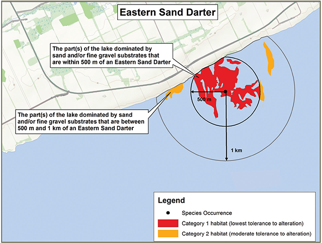
For lake populations (including areas in Lake Erie, Lake St. Clair, and West Lake) and the Detroit River, the habitat regulation protects the area of the lake or river within 1 kilometre of where an Eastern Sand Darter has been found, up to the high water mark, that has substrate dominated by sand (0.06mm – 2mm) and/or fine gravels (>2mm – 8mm). Unoccupied tributaries on lakes or the Detroit River are not included in the regulation.
The regulation does not apply to areas of the Sydenham River downstream of the bridge on County Road 21 in the town of Dresden.
Habitat categorization
The following text indicates how the species’ habitat would be categorized, as per the policy Categorizing and Protecting Habitat under the Endangered Species Act.
Category 1 (Red)
- The part(s) of the lake or watercourse segment that are within 500 metres of where an Eastern Sand Darter has been found and are dominated by sand (0.06mm – 2mm) and/or fine gravel (>2mm – 8mm) substrates
Category 2 (Orange)
- The part(s) of the lake or watercourse segment that are further than 500 metres from the species and are dominated by sand (0.06mm – 2mm) and/or fine gravel (>2mm – 8mm) substrates. For lakes and the Detroit River, this applies to a maximum of 1 kilometre from an Eastern Sand Darter
Category 3 (Yellow)
- All other areas within a watercourse segment (with the exception of the Detroit River) in which Eastern Sand Darter is found
- Areas of natural or semi-natural vegetation within 30 metres of the occupied watercourse segment
Sample application of the habitat regulation

Enlarge Sample application of the habitat regulation
Sample application of the habitat regulation in lakes or the Detroit River
Enlarge sample application of the habitat regulation in lakes or the Detroit River
This content is summary only. For accurate reference of the regulation, please view Ontario Regulation 242/08 on e-laws.
This protection applies to areas that were used by the species anytime in the past four years. If the species was last observed more than four years ago, the MNRF considers the species to still be present at the site unless one of the following occurs:
- four consecutive years of MNRF-approved surveys have been conducted and indicate that the species no longer exists at the site, or
- the species has been formally designated as extirpated at the specific site.
The regulation applies where the species is found in the counties of Brant, Chatham-Kent, Essex, Elgin, Haldimand, Middlesex, Norfolk, and Prince Edward, the parts of Lambton County composed of the lower-tier municipalities of Brooke-Alvinston and Dawn-Euphemia, and the Detroit River, Lake Erie and Lake St. Clair.
Supporting rationale
- The Eastern Sand Darter has been demonstrated to be strongly associated with sandy substrates and fine gravel.
- If a population has been found in one part of a watercourse segment, it is likely to be found in suitable habitat in other areas of the same segment.
- Small-bodied fish are suggested to have limited movements, generally less than 500 metres however, populations may disperse throughout a river when a preferred habitat is lost.
- Declining water quality is one of the primary threats to riverine populations of Eastern Sand Darter. Protecting vegetated areas within 30 metres of the high water mark will reduce contamination of the aquatic habitat.
- The four-year period allows for sufficient time to determine that the site is no longer being used, based on the species’ life span and detectability.
Activities in Eastern Sand Darter habitat
Activities in regulated habitat can continue as long as the function of these areas for the species is maintained and individuals of the species are not killed, harmed, or harassed. Activities are evaluated on a case-by-case basis for compatibility with regulated habitat.
Generally compatible
- Recreational use of the water such as swimming and boating
- Recreational fishing
- Continuing to farm cropland already in production
Generally not compatiblefootnote *
- Significant alteration of aquatic habitat (e.g., vegetation, streambed), water temperature and water chemistry
- Dredging, installation of bridges, culverts or pipeline crossings or the construction of dams
- Land-based activities that negatively affect water quality (e.g., that result in the input of excess nutrients, sediment or toxic substances)
Please note that any activity that occurs outside of regulated habitat but that has a reasonable potential to negatively impact regulated habitat could require authorization under the ESA.
Landowners with species at risk habitat on their property may be eligible for funding programs that support stewardship activities to help protect and recover species at risk, such as the Species at Risk Stewardship Fund or the Species at Risk Farm Incentive Program. Visit Species at risk or contact your local MNRF office for more information.
Key terms
- Watercourse segment: A distinct section of a river or stream characterized by relatively similar hydrography and surficial geology and which is not separated by in-stream barriers that prevent fish movement. The Protocol for Applications Used in the Aquatic Landscape Inventory Software Application for Delineating, Characterizing and Classifying Valley Segments within the Great Lakes Basin (Stanfield and Kuyvenhoven, 2002) describes in more detail how the boundaries of segments are delineated. This protocol and files which show the mapped watercourse segments are available through Land Information Ontario.
Footnotes
- footnote[*] Back to paragraph If you are considering an activity that may not be compatible with regulated habitat, please contact your local MNRF office for more information.