Henwood Township Forest and Wetland Conservation Reserve Management Statement
This document provides policy direction for the protection, development and management of the Henwood Township Forest and Wetland Conservation Reserve and its resources.
C1623
Henwood Township Forest and Wetland Conservation Reserve Statement of Conservation Interest (SCI)
May 2002
Kirkland Lake District
Ministry of Natural Resources
Approval statement
I am pleased to approve this Statement of Conservation Interest (SCI) for the Henwood Township Forest and Wetland Conservation Reserve.
Direction for establishing, planning and managing conservation reserves is defined under the Public Lands Act and current policy.
Ontario’s network of natural heritage areas has been established to protect and conserve areas representative of the diversity of the natural regions of the province, including species, habitats, features and ecological systems which comprise that natural diversity. (Policy 3.03.05, MNR 1997).
This SCI will provide guidance for the management of the conservation reserve and the basis for the ongoing monitoring of activities. More detailed direction at this time is not anticipated. Should significant facility development be considered or complex issues arise requiring additional studies, more defined management direction, or special protection measures, a more detailed Conservation Reserve Management Plan will be prepared with full public consultation.
The public was consulted on this site prior to its regulation during the planning for Ontario’s Living Legacy (MNR, 1999). Furthermore, the public was notified during a 30 day period in December, 2001 concerning a draft of this SCI. Comments from the notification period have been considered in the development of this document.
The conservation reserve will be managed under the jurisdiction of the Kirkland Lake/Claybelt Area Supervisor of the Ministry of Natural Resources, Kirkland Lake District.
Plan Author:
William Foy
Ontario’s Living Legacy Resource Manager
Kirkland Lake District
Approved by:
Craig Greenwood,
District Manager
Kirkland Lake
Approved by:
Rob Galloway,
Regional Director
Northeast Region
1.0 Introduction
Ontario’s network of natural heritage areas has been established to protect and conserve areas representative of the diversity of the natural regions of the province, including species, habitats, features and ecological systems which comprise that natural diversity. Protected natural heritage areas are a key component in sustainable management of natural resources. They ensure that representative sites within the larger sustainable managed landscape are permanently retained in their natural state.
These areas are considered to be sensitive, requiring protection from incompatible activities if their values are to endure over time. The Ministry of Natural Resources has established conservation reserves as a new tool to offer protection for natural heritage areas on public lands, while permitting many traditional public lands uses to continue. Such uses include the traditional activities of Aboriginal peoples.
Ontario’s Living Legacy Land Use Strategy (OLL LUS MNR 1999) will set the direction for the administration and management of parks and protected areas on Crown lands within three planning regions including; the Boreal West, Boreal East and Great Lakes- St. Lawrence areas. This strategy’s natural heritage objectives include protection of natural and cultural heritage values and the provision of opportunities for outdoor recreation, heritage appreciation and tourism (MNR 1999).
Protected areas designated within the (OLL LUS MNR 1999) have been selected based on their representation of the spectrum of the province’s ecosystems and natural features including both biological and geological features, while minimizing impacts on other land uses. Representation was described using landform and vegetation combinations based on Hills (1959) site district concept.
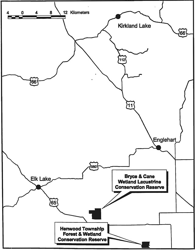
The Henwood Township Forest and Wetland Conservation Reserve is a 322 ha parcel of Crown land that is situated just west of Highway 562 and approximately 15 km southwest of the town of Earlton, Ontario. The conservation reserve is located within Henwood township. This township is situated in the Kirkland Lake District within the MNR's Northeast Region. The conservation reserve will be managed under a Statement of Conservation Interest.
Statement of Conservation Interest (SCI) documents are the minimum level of management direction established for any conservation reserve and generally are brief management plans. This SCI will govern the lands and waters within the regulated boundary of the conservation reserve. However, to ensure MNR protection objectives are being fully met within the conservation reserve, the surrounding landscape and related activities must consider the site’s objectives and heritage values. In addition, it is the intent of this SCI to create a public awareness that will promote responsible stewardship of protected areas and surrounding lands. With management partners such as Ontario Parks, industry, local governments, etc., MNR District Offices will be able to pursue and advance sound environmental, economic and social strategies and policies related to the protection of conservation reserves and provincial parks. The conservation reserve will be managed under a statement of Conservation Interest (SCI).
The purpose of this SCI is to identify and describe the values of the Henwood Township Forest and Wetland Conservation Reserve and outline the Ministry’s management intent for the conservation reserve. The management direction will protect the site’s natural heritage values and demonstrate its compatibility within the larger sustainable landscape. This direction will comply with land use intent as stated by the OLL Land Use Strategy (MNR 1999).
2.0 Goals and objectives
2.1 Goals of statement of conservation interest
The goals of this SCI will be to describe and protect natural heritage values on public lands while permitting compatible land use strategies.
2.2 Objectives of SCI
2.2.1 Short term objectives
To identify the State of the Resource with respect to natural heritage values and current land use activities for the conservation reserve. A priority will be placed on the protection of the site’s natural values via specific guidelines, strategies and prescriptions detailed in this plan. Finally, legislated planning requirements will be met (e.g. SCI development within three years of regulation).
2.2.2 Long term objectives
The long-term objectives will be to establish representative targets (e.g. future forest conditions) and validate the site as a potential scientific benchmark. To ensure protection of natural and cultural heritage features and values, this SCI will establish an evaluation process to address future new uses and commercial activities associated with them (e.g. Test of Compatibility Procedural Guideline B in Conservation Reserve policy PL 3.03.05). Finally, this SCI will identify research/client services and marketing strategies.
3.0 Management planning
3.1 Planning area
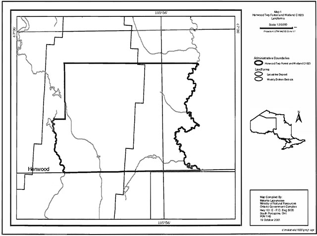
The planning area for this site will consist of the regulated boundary for the Henwood Township Forest and Wetland Conservation Reserve (See Land Use Map, Appendix 7). This landbase will form the area directly influenced by this Statement of Conservation Interest. The plan will recognize the protection of values within the planning area; however, to fully protect values within the conservation reserve additional consideration within larger land use or resource management plans may be required. Nevertheless, any strategies noted within this plan related to the site’s boundary or beyond will need to be presented for consideration within a larger planning context.
3.2 Management planning context
The Henwood Township Forest and Wetland Conservation Reserve was designated as a candidate conservation reserve by MNR in the OLL Proposed Land Use Strategy (MNR March 1999) and eventually as a conservation reserve in the final OLL Land Use Strategy (MNR 1999). The site was regulated under an amendment of Ontario regulation 805/94 made under the Public Lands Act on April 6, 2001. Management and planning direction for this site will be via the OLL LUS (MNR 1999) and this management statement. The area encompassed by this site has also been removed from the Sustainable Forest License (SFL) landbase.
By regulation this conservation reserve cannot be used for commercial forest harvest and hydroelectric power development. Existing permitted uses within this reserve will continue to be permitted, therefore such activities as fishing, hunting and trapping will be permitted to continue. This SCI and future management will continue to try and resolve conflicts regarding incompatibility between uses and to ensure that identified values are adequately protected.
This Statement of Conservation Interest will only address known issues or current proposals with respect to permitted uses or potential economic opportunities brought forward to the District Manager during this planning stage. However, in terms of approving future permitted uses and/or development(s), there are established mechanisms in place to address such proposals. Any future proposals will be reviewed using the Procedural Guideline B - Land Uses - Test of Compatibility Public Lands Act Policy PL 3.03.05 (MNR 1997) or other standard MNR environmental screening processes. There are no identified development or current structures located within the boundaries of the site.
Consideration for proposals pertaining to cultural resources may be screened through Conserving a Future for our Past: Archaeology, Land Use Planning & Development in Ontario, Section 3 (MCzCR, 1997) and MNR's history in establishing AOC descriptions and prescriptions for cultural heritage resources within forest management plans (FMPs).
These planning tools will help refine the review process once the proposal satisfies the direction and intent of the Public Lands Act, associated policies and this planning document.
3.3 Planning process
Once a Conservation Reserve is passed into regulation, it must be determined what level of management planning is required to fulfill the protection targets. There are two policy documents involved. A Statement of Conservation Interest (SCI) is the minimal requirement for providing planning direction, and a Resource Management Plan (RMP) that deals with more complex issues where several conflicting demands are placed on the resources. The guidelines for the preparation of these documents is outlined in Procedural Guideline A - Resource Management Planning (Conservation Reserves Procedure PL 3.03.05 Public Lands Act). The appropriate plan must be completed within three years of the regulation date.
For current planning purposes, the Henwood Township Forest and Wetland Conservation Reserve will be managed under the auspices of a Statement of Conservation Interest. Interested parties from both the private and public sectors were consulted during the OLL planning process from candidate conservation reserve to regulation. The intent of this SCI is to fulfil the commitments made within the OLL LUS (MNR 1999). In addition, a public notification of a draft of this SCI document occurred for a period of 30 days during January 2002. During this period, the MNR received no new permitted use or development proposals for this conservation reserve. Therefore, no new decisions have been identified by the MNR since the implementation of the OLL strategy.
The revised SCI was reviewed by the Kirkland Lake District Manager (DM). Upon approval by the DM the SCI was presented to the Regional Director (RD) for final approval.
Following RD approval, interested public, user groups and industry were notified that the Statement of Conservation Interest for the Henwood Township Forest and Wetland Conservation Reserve was approved.
Public consultation will be solicited during a review of any future land use proposals that would require new decisions to be made. In addition, any future proposal and/or any new, significant management direction considered will be published on the Environmental Bill of Rights Registry (EBR).
The SCI is a policy document that will provide background information, identify values to be protected and establish management guidelines for use in the administration of the reserve.
The implementation of the policy will be the mandate of the MNR at the district level, however associations with various partners may be sought to assist :in the delivery. This SCI is a working document; therefore it may be necessary to make revisions to it from time to time.
4.0 Background information
4.1 Location and site description
4.1.1 Location
The following table describes the location and provides administrative details of the site:
Name: Henwood Township Forest and Wetland Conservation Reserve
Site - Site District (Hills): 4E Lake - 4E-5 New Liskard
Site Region - Site District (Crins and Uhlig): 4E-5
MNR Administrative Region/District Area: Northeast Region / Kirkland Lake District in the Area
UTM co-ordinates: E 579500 N 5271000
Nearest town/municipality: East of Elk Lake / South of Kenabeek
Township(s): Henwood
OBM Numbers: 17 5700 52700 - 17 5800 52700; 17 5700 52600 - 17 5800 52600
Topographical Map Name/Number: New Liskeard 31 M/12
Wildlife Management Unit: 28
Forest Unit: Timiskaming Forest Table 1: Location Data
4.1.2 Site description
4.1.2.1 Physical description
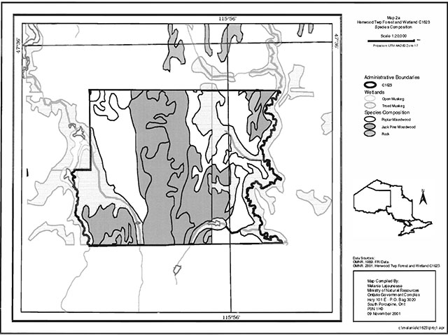
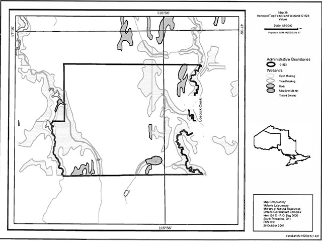
Henwood Township Forest and Wetland Conservation Reserve is a 322 ha parcel of Crown land that is situated just west of Highway 562 and approximately 15 km southwest of the town of Earlton, Ontario. The conservation reserve is located along the township boundary line between Henwood and Lundy townships. It is located on the edge of Hills (1959) Site District 4E-5, an undulating clay plain (i.e. The Little Clay Belt) enclosed by Precambrian ridges with shallow mantels and deep pockets of sand, silt and localized clay areas (MNR 1992). This description matches Rowe (1972) description of the Haileybury Clay Forest Section. Forests are transitional between the Great Lakes St. Lawrence and the Eastern Boreal Forest Regions. Black spruce is characteristic on lacustrine deposits and in association with balsam fir, white birch and trembling aspen. Major disturbance is by fire or by agricultural clearing (Rowe 1972). This site consists of weakly broken bedrock with brush and alder, open wetland, spruce, larch, and treed wetland. Also present is lacustrine deposit with old balsam poplar, jack pine, and open muskeg, and rock.
The key values within the conservation reserve include the following;
- jack pine mixed woods and jack pine- black spruce on bedrock (i.e. greater than 50% exposed bedrock) and bedrock drift complex
- poplar mixed woods on glaciolacustrine deposits
- assorted wetlands including alder shrubs that form thicket swamps to shoreline fen areas to meadow marshes which are associated with glaciolacustrine or organic deposits
The site is drained through its wetland complexes that are mostly associated with Leacock Creek or an intermitted tributary of Wabi Creek along the western border of the site.
4.2 Administrative description
The legal boundaries of the Henwood Township Forest and Wetland Conservation Reserve were filed on January 12, 2001 in the Office of the Surveyor General, Ministry of Natural Resources in Peterborough, Ontario. The site was regulated on April 6, 2001. Presently the conservation reserve is located within the Sustainable Forest License of the Timiskaming Forest Alliance Inc. (TFAI).
Natural heritage inventories of such components as earth science, life science and recreation were conducted for this site during June to August of 2001. Silvicultural assessment of the clear cut areas in northern portion if the site is required. As well additional life science inventory to define values is required.
4.3 History of site
This site contains one Bear Management Area, one baitfish area and one trapline. The central portion of the site was harvested in 1997. There is a secondary forest access road that runs through the middle of the site.
4.4 Inventories
The following table indicates the current status of natural heritage inventory that has occurred or is required in the near future:
| Survey Level | Earth Science | Life Science | Cultural | Recreational | Other |
|---|---|---|---|---|---|
| Reconnaissance | August 2001 | August 2001 | Not required at this time. | June/July 2001 | |
| Detailed Requirement | Silvicultural assessment of the clear cut area in the site. Additional life science inventory to define values is required. |
5.0 State of the resource
Representation:
Henwood Township Forest and Wetland Conservation Reserve is located within the low hummocky terrain of the Cobalt plain which contains flat lying sedimentary Precambrian bedrock (Bostock 1970). Many of the local conservation reserves had life science gap
The glaciolacustrine deposits within the northwestern portions of the conservation reserve support poplar dominated mixed woods, a small portion of a jack pine coniferous community, alder shrubs, and a pure poplar stand. Glaciolacustrine deposits are more associated with wetlands related to Leacock Creek that forms the eastern boundary of the site. Here alder shrub and tall shrub shoreline fen
Organic deposits are restricted to the large wetland complex associated with the western boundary of the site and the intermittent tributary of Wabi Creek. Here meadow marshes
Quality of representation:
The quality of the representation or the current characteristics of the natural features found within the conservation reserve are as important as the overall representative features that are being protected. A number of factors are considered in evaluating a site and they include the following criteria; diversity, condition, ecological factors, special features and current land use activities.
- Diversity:
Diversity is evaluated in terms of the number and range (i.e. amount of richness and evenness) of vegetative communities currently present within the conservation reserve Natural landscapes and known generalized vegetative communities will be the scale used for this Statement of Conservation Interest. Future aerial or ground reconnaissance surveys will enhance the MNR's knowledge of these features and possibly allow verification at a lower scale (e.g. species assemblages).
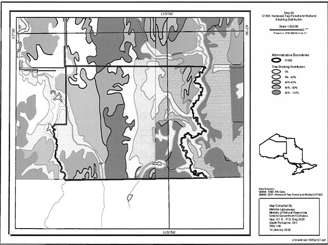
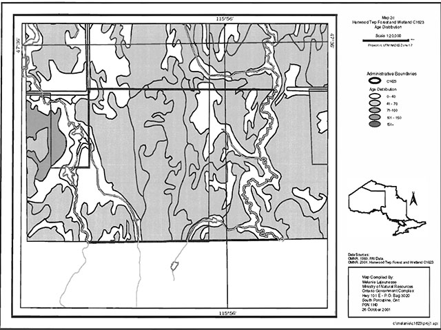
Based on the reconnaissance survey completed in August 2001, this site’s diversity is relatively poor due to its small size, past disturbance, few landform and vegetative communities combinations present and the dominance of a. couple of communities. Its evenness is heavily skewed towards even aged (approximately 62 year old
footnote 4 ) jack pine mixed woods or jack pine coniferous stands on predominately bedrock or bedrock. drift complexes. (See appendix 7) - Condition:
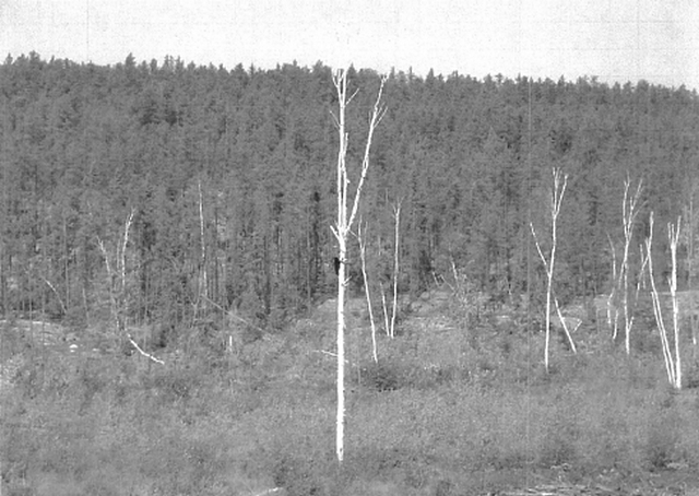
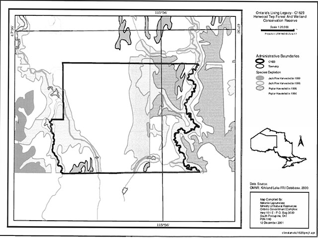
Condition is the degree of past human and natural disturbances observed or recorded for the site. Approximately 17 percent of the site was harvested in 1998. Jack pine on bedrock and bedrock drift landforms and poplar mixed woods on glaciolacustrine and bedrock were harvested for a total of 56 hectares. Access trails and old roads occur within these harvested areas; however, their degree of development is very poor. Little to no regeneration of the jack pine was noticed during the aerial survey; however, some poplar regeneration was occurring in the northeast corner of the conservation reserve.
During the August 2001 aerial reconnaissance survey the poplar communities in the northwestern corner of the site showed evidence of insect mortality due to forest tent caterpillar infestations. The remaining forest communities were very even aged between 62 years for all jack pine communities listed and 72 years for poplar stands suggesting a stand replacing disturbance, probably fire occurring approximately 60 to 70 years ago. Regardless of past disturbance, the remaining forests and wetlands remain intact.
- Ecological Factors:
Ecological factors refer to the current design of the conservation reserve as noted by its size, shape, buffering capacity to adjacent land use activities. In addition the site’s current age to undisturbed landscapes also contribute to the conservation reserve’s ecological integrity. Additional limited amount of Crown lands surround most of the site; however the conservation reserve is nested within a patent lands matrix for the most part. Currently, patent lands are directly adjacent to the northwest and southeast corners. The site’s design is weakened by the small size of the site resulting in a lack of protection of core values, vectored boundaries that form its northern, southern and northwestern boundaries and the amount of recent human disturbance that has occurred within the site as previously mentioned. Most of the core values for the site are not entirely enclosed within the boundaries of the site with most forest communities and landforms extending beyond the conservation reserve’s boundaries. Such design limitations and current disturbances will make managing this site problematic over the long term. The use of Leacock Creek along the conservation reserve’s eastern boundary and the biological boundary established along the southwestern boundary should help the site resist effects of adjacent land use. activities. Opportunities for ecological restoration are currently available for the recently harvested areas of the site.
- Special Features:
Due to the site’s small size and extensive disturbances the number of special features present is limited to the life science representation previously discussed. No special terrestrial or aquatic floral or faunal features have been documented for the site to date. Finally, those forest and wetland communities that exist within the conservation reserve are still highly valued, since most of the vegetative communities present within Site District 4E5 have been extensively effected by agricultural or other human developments.
- Current Land Use Activities
Only a small number of uses are known to be associated with this site. Activities include berry picking, hunting, trapping, ATV use, snowmobiling, and hiking.
Summary
Henwood Township Forest and Wetland Conservation Reserve contribution to the parks and protected areas system has not been assessed at the Site District level to date; therefore its role as a provincially significant area must be determined and compared to all existing and new OLL protected areas. Furthermore the site’s small size and poor design suggest that future management will need to consider its protection in larger landscape planning exercises. It relatively low diversity and significant disturbed areas as a result of past harvests and recent insect damage may result in future managers considering monitoring successional changes or possible developing a restoration ecology strategy for the site. Regardless of the earth or life science values currently present, the site does contribute some undisturbed forest stands and wetlands which are valued within the heavily disturbed Site District 4E-5.
Natural heritage representative features
This site consists of weakly broken bedrock with brush and alder, open wetland, spruce, larch and treed wetland. Also present are lacustrine deposit with old balsam poplar, jack pine and open muskeg and rock. The following is a list of the landform type and the associated vegetation type. (for more information see section 5.2 Natural Heritage Stewardship)
Landform – Vegetation (LV) Type
| Landform | Vegetation |
|---|---|
| Weakly Broken Bedrock | Brush and Alder |
| Weakly Broken Bedrock | Open Muskeg |
| Weakly Broken Bedrock | Spruces (young) |
| Weakly Broken Bedrock | Tamarack (Middle) |
| Weakly Broken Bedrock | Treed Muskeg |
| Lacustrine Deposit | Balsam (Old) |
| Lacustrine Deposit | Jack Pine (Old) |
| Lacustrine Deposit | Open Muskeg |
| Lacustrine Deposit | Rock |
Forest Resource Inventory (FRI) Data
- Dominant species, wetlands and depleted areas
- See Forest Stand Composition Map, Appendix 7
Values
- Cold water fish species streams
5.1 Social/economic interest in area
- Linkage to Local Communities
The Henwood Township Forest and Wetland Conservation Reserve is a 322 ha parcel of Crown land that is situated just west of Highway 562 and approximately 15 km southwest of the town of Earlton, Ontario. The conservation reserve is located within Henwood township. It is located on the edge of Hills (1959) Site District 4E-5, an undulating clay plain (i.e. The Little Clay Belt) enclosed by Precambrian ridges with shallow mantels and deep pockets of sand, silt and localized clay areas (MNR 1992). This description matches Rowe (1972) description of the Haileybury Clay Forest Section.
Current uses are restricted to consumption of fish and wildlife resources and snowmobiling. Potential recreational activities could include ATV riding and possibly non-consumptive uses such as bird watching or nature study. The present condition of the wetlands would make access into some of these areas difficult due to water levels and thickness of growth. In its present condition, the social and economic interest in the area is not likely to be expanded beyond the current uses.
- Heritage Estate Contributions
The Henwood Township Forest and Wetland Conservation Reserve Conservation Reserve contributes to the province’s parks and protected areas system through its regulation, representation and the long-term management of its natural heritage values.
By allocating these lands to the parks and protected areas system through regulation, the province has ensured a certain level of permanence by distinguishing the site and its values from the larger general use or more extensively managed landscape. In addition, its natural features are, and will be available for present and future generations to enjoy and explore.
Long term management must consider public access to the site, the conservation reserve protection objectives, and commitments made in the OLL strategy (MNR 1999). Future managers will have to consider if restoration ecological actions are required within the disturbed zones or whether natural vegetative succession and long term monitoring of these disturbed areas is more appropriate.
- Aboriginal Groups
The aboriginal groups in the area have not currently identified any traditional use areas or areas of interest within the site.
- Mining Interests
There are no known current mining interests related to the conservation reserve. Mining and surface rights have been withdrawn from staking within the conservation reserve’s boundaries under the Mining Act (RSO 1990 Chapter M.14).
- Forest and Fire Management History:
The site has been affected by recent forest management activities. In 1998, approximately 22 ha of the poplar mixed woods were harvested leaving a disturbed area of old roads and trails, open grassy areas and pole sized trembling aspen regeneration occurring on the site. Also 34 ha of jack pine were harvested in the same year. The site has no recent burned areas within its boundary.
5.2 Natural heritage stewardship
Preliminary analysis of the life science targets based on landform/vegetation combinations showed the site contained 9 such combinations. A recent aerial reconnaissance survey showed significant pre-OLL harvest areas located throughout the northern portion of the site. A total of four earth science landform features exist within the site including organic deposits, glaciolacustrine deposits, bedrock terrain, and bedrock-drift complex. No outwash deposits occur within the site.
The number of landform/vegetation combinations, which includes known forest stands and wetlands, exceeds expectations. However, a number of vegetative communities gained were also severely impacted due to recent harvesting.
No permanent MNR sampling plots are associated with the site.
5.3 Fisheries and wildlife
The Fish and Wildlife Values identified are cold-water fish species streams. Fishing opportunities are limited due to the lack of watercourses and lakes. Wabi Creek, which flows through the site, was stocked with brook trout during the 1950's. Angler records indicate that the creek produced a viable brook trout fishery during the late 1950's.
The dominant forest stands within this site are comprised of jack pine and poplar. The site also contains wetlands dominated by alders. All of these habitats, as well as the sections that have been harvested, provide year round habitat for moose as well as other species.
5.4 Cultural heritage stewardship
To date, a detailed assessment of cultural resources has not been carried out.
5.5 Land use/existing development
The reserve rests on Crown land and is unencumbered by any land use permits, leases or mining claims. Mining and surface rights have been withdrawn from the reserve (MNDM G-Plan M-0282 December 12, 2001). There are no existing facilities in the conservation reserve. A number of non-maintained forest extraction roads exist in the site.
5.6 Commercial use
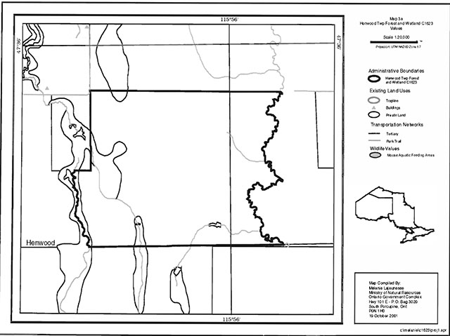
Present commercial use activities include one resident trapline, one bear management area (BMA KL-28-49) and one baitfish operation (baitfish block KL-11). (See Land Use Map, Appendix 7)
5.7 Tourism recreation use/opportunities
Some of the recreational features within this site include wetland vegetation, coniferous and deciduous forest stands, large land mammals and exposed bedrock. Existing recreational uses in this site and the immediate area surrounding the site include trapping, large game hunting and fishing. There is also potential for activities such as ATV use, snowmobiling, hiking, small game hunting and berry picking.
For a more detailed report and summary of the recreational use and potential refer to the Recreational Inventory Check-sheet.
5.8 Client services
Currently visitor services are limited to responding to inquiries about access, natural heritage features and boundaries.
Other client services include providing clients with maps, fact sheets and other information gathered on the area, such as the Earth Life and Recreational inventory work.
6.0 Management guidelines
6.1 Management planning strategies
The land use intent outlined in the LUS provides context and direction to land use, resource management, and operational planning activities on Crown land. Commitments identified in the above strategy and current legislation (Policy 3.03.05 PIA) will form the basis for land use within Henwood Township Forest and Wetland Conservation Reserve. Management strategies for these uses must consider the short and long-term objectives for the reserve. For up to date information on permitted uses refer to the Crown Land Use Atlas.
Proposed uses and development will be reviewed on a case-by-case basis. A Test of Compatibility, (Procedural Guideline B Land Uses (PL 3.03.05) must be passed before they are deemed acceptable. The emphasis will be on ensuring that the natural values of the conservation reserve are not negatively affected by current and future activities. Therefore any application for new specific uses will be carefully studied and reviewed.
6.2 State of the Resource
management strategies
The development of this SCI and the long term management and protection of Henwood Township forest and Wetland Conservation Reserve. Will be under the direction of the MNR's Kirkland Lake District, Kirkland Lake/Claybelt Area Supervisor. The following management strategies have been created to achieve the goal and objectives stated earlier in this management document.
Natural heritage stewardship
The management intent for the Henwood Township Forest and Wetland Conservation Reserve is to allow for natural ecosystems, processes and features to operate undisturbed with minimal human interference while providing educational, research and recreational
activities. Forest ecosystem renewal will only be entertained via a separate vegetative management plan. As part of any future vegetative management plan the site and its Site District will be re-evaluated with respect to their known landform vegetative features to determine if the past harvested areas could contribute additional landform/vegetative values to the Site District. In addition the vegetative management plan will need to determine but not be limited to;
- the restoration ecology objectives (e.g. representation) for the area in context with the Site District;
- consider current provincial strategies (e.g. white pine);
- consider larger long-term conservation reserve (e.g. recreational objectives) and possibly landscape objectives (e.g. contributions to landscape wildlife objectives).
Forest fire protection will be carried out as on surrounding public lands, under the direction of the provincial fire strategy. All wildfire occurrences will be considered a high priority and will actively be suppressed. Prescribed burning will be conducted only under the direction of the provincial tire strategy and authorized for the conservation reserve under a separate vegetative management plan. Prescribed burning may be utilized if deemed necessary to emulate natural disturbances and renew forest communities, prepare seed beds for research and/or education purposes or to meet additional objectives determined within a separate vegetative management plan.
Defining compatible uses, enforcing regulations and monitoring and mitigating issues will protect all earth and life science features. Industrial activities such as; commercial timber harvest and new hydro generation will not be permitted within the conservation reserve. Permits for fuel-wood will not be issued. Energy transmission, communication and transportation corridors or construction of facilities are not permitted within the boundaries of the conservation reserve. Such structures negatively impact on the quality of the representative features that require protection. Alternatives should be reviewed via larger landscape planning processes. New roads for resource extraction will not be permitted. Other activities that do not pass a Test of Compatibility will be prohibited (MNR Policy 3.03.05, 1997).
The introduction of exotic and/or invasive species will not be permitted. Programs may be developed to control forest insects and diseases where there is a concern that significant values may be compromised. Remedies must focus on the outbreak or infestation. Biological or non-intrusive solutions should be applied whenever possible.
The collection/removal of vegetation and parts thereof will not be permitted; however, subject to a Test of Compatibility, the Area Supervisor may authorize such activities for purposes of rehabilitating degraded sites within the reserve, collecting seeds for maintaining genetic stock and/or for inventory or research purposes.
Silvicultural assessment of the previous clear-cut areas in the northern portion of the site should be conducted to support any future vegetative management plan. The evaluated should consider but not be limited to the following objectives:
- describing the current forest condition;
- determining soil type and depth;
- defining potential restoration prescriptions. Such prescriptions must consider current silvicultural science and guidelines and additional objectives established by the MNR.
MNR will provide leadership and direction for maintaining the integrity of this site as a heritage estate. To ensure MNR protection objectives are fully met within the conservation reserve, activities on the surrounding landscape must consider the site’s objectives and heritage values. Research, education and interpretation will be encouraged to provide a better understanding of the management and protection of the natural heritage values and will be fostered through local and regional natural heritage programs, initiatives and partnerships.
The conservation reserve will be managed by allowing natural ecosystems, processes, and features to operate normally, with minimal human interference.
Programs may be developed to control forest insects and diseases in the conservation reserve where these threaten significant heritage, aesthetic, or economic values. Where control is desirable, it will be directed as narrowly as possible to the specific insect or disease. Biological control will be used wherever possible.
Fisheries and wildlife
Fishery and wildlife resources will continue to be managed in accordance with specific policies and regulations defined by the Ontario Ministry of Natural Resources under the Fish and Wildlife Conservation Act and the Kirkland Lake District, Claybelt Area Supervisor.
Fishing and hunting will continue at a low level of intensity. A planned trail and viewing area development may enhance wildlife viewing activities. Any future trail development will require a test of compatibility and an amendment to the Statement of Conservation Interest.
Cultural heritage
When possible, the Ministry of Natural Resources will continue to work with the Ontario Ministry of Culture, Tourism and Recreation in identifying archaeological sites to be protected. To more fully manage and protect sites, the development of field surveys will be required. However at this time additional field surveys are not recommended.
Development, research and education proposals may be considered in accordance with the Test of Compatibility; Conserving a Future for our Past: Archaeology, Land Use Planning & Development in Ontario, Section 3 (MCzCR, 1997).
Social/economic
Forest fire protection will be carried out as on surrounding public lands, until alternative direction for the control of fife, or the use of fife for management purposes, is approved through a more detailed local natural resource plan or management plan.
Land use and development
The sale of lands within the conservation reserve is not permitted as per the OLL LUS (MNR 1999). Existing authorized trails can continue unless there are significant demonstrated conflicts. New trails will only be allowed if a Test of Compatibility is Passed. Any new trail development will require an amendment to the SCI. The cutting of trees for non-commercial purposes (e.g. fuelwood) is not permitted unless as a result of permitted development activity (e.g. trail, viewing site).
New roads for resource extraction will not be permitted. Abandoned forest extraction roads will not be actively maintained.
Commercial use
All existing commercial bait fishing and commercial bear hunting (within BMAs) operations are permitted to continue. Commercial bear hunting operations, for non-residents, is permitted and the transfer of existing licenses is allowed as per existing fish and wildlife directives.
Existing commercial fur harvesting operations are permitted to continue. New operations may be considered subject to a Test of Compatibility. No new trap cabins will be permitted.
Aboriginal interests
Aboriginal and treaty rights will continue to be respected.
Tourism/recreation
The earth and life science features and their protection, shall be the overall theme for tourism. Small-scale infrastructures for enhancing tourism and recreation (i.e. warm-up shelter) may be considered, providing they pass a Test of Compatibility and other MNR requirements.
Most recreational activities that have traditionally been enjoyed in an area can continue provided they pose little or no threat to the natural ecosystems and features protected by the Conservation Reserve. These permitted activities include walking, hiking, wildlife viewing, fishing, hunting, snow shoeing, and cross-country skiing.
Snowmobiles and All-Terrain Vehicles are permitted on existing trails and forest access roads within the Conservation Reserve. Under the existing LUS, all mechanized travel is restricted to existing trails. Off trail vehicle use is permitted for the retrieval of game only.
Existing trails for hiking, snowmobiling, ATV use, cycling, horse riding and cross-country skiing can continue pending they do not impact or degrade the values within the site. To ensure the quality of representation is maintained all trails and old forest access roads within the sire should be identified via new technologies (i.e. GPS) to ensure a record of the features exist. New trails can be considered through a Test of Compatibility. If new trails are approved then an amendment to the SCI will occur.
Finally, conflict resolution between recreational uses will be a priority. This will be achieved by adhering to- the objectives of this SCI with input from relevant user groups. The level of safety and compatibility between activities will determine permitted uses (i.e., Test of Compatibility).
Client services
Clients indicating their interest in the management, planning and future use in the conservation reserve will be put on a mailing list and notified of any future planning in the site.
Present client services such as supplying maps, fact sheets and other information will also continue. Information may be delivered from different sources, however, MNR will be the lead agency for responding to inquiries regarding access permitted and restricted activities, values and recreation opportunities. A management agreement may be pursued with an appropriate partner to share responsibilities for information services and the delivery of other aspects of this SCI in the future.
6.3 Specific feature/area/zone management strategies
There are no specific management strategies for the maintenance/protection/enhancement of selected resources within the conservation reserve. Development of such strategies will require an amendment to the SCI.
6.4 Promote inventory, monitoring and assessment reporting (IMAR), and research
Scientific research by qualified individuals, w1hich contributes to the knowledge of natural and cultural history and to environmental and recreational management, will be encouraged, Additional earth and life science research is required at this time to refine values and features. Additional assessment and monitoring of the disturbed areas, including trail and old road locations, within the site should occur prior to any additional management direction developed via a vegetative management plan for the area.
Research related to the study of natural processes will be encouraged provided it does not harm the values of the reserve. The Claybelt Area Supervisor may approve the removal of any natural or cultural specimen by qualified researchers. All such materials removed remain the property of the Ministry of Natural Resources. All research programs will require the approval of the Ministry of Natural Resources and will be subject to Ministry policy and other legislation.
New research developments such as campsites, privies, trails or developed access points or activities will not be considered until a Test of Compatibility is conducted and proposal is approved by the Claybelt Area Supervisor. The Test of Compatibility or environmental screening process could include a review of the demand for structures or activities and may require more detailed life or earth science or cultural information and possibly more detailed management plan.
Approved research activities and facilities will be compatible with the protection objective. Permanent plots or observation stations may be established to which researchers can return over time. Any site that is disturbed will be rehabilitated as closely as possible to its original state.
6.5 Implementation, and plan review strategies
The Henwood Township Forest and Wetland Conservation Reserve Statement of Conservation Interest will be reviewed on an ongoing basis and as required. Implementation of the SCI and management of the reserve are the responsibility of the Area Supervisor. Partnerships may be pursued to address management needs.
If changes in management direction are needed at any time, the significance of the changes will be evaluated. Minor changes that do not alter the overall protection objectives may be considered and approved by the District Manager without further public consultation and the plan will be amended accordingly. In assessing major changes, the need for a more detailed Conservation Reserve Management Plan will first be considered. Where a management plan is not considered necessary or feasible, a major amendment may be considered with public consultation. The Regional Director will approve major amendments.
6.6 Marketing strategies
The Henwood Township Forest and Wetland Conservation Reserve will be marketed as a representative natural area having earth and life science values, as well as certain recreational values. Marketing efforts to increase use are not a priority and will be kept to a minimum.
6.7 Boundary identification
There is no stated policy requirement to mark the boundaries of a Conservation Reserve.
Local management discretion can be used to determine where boundary marking may be appropriate. In order for restrictions to be enforceable, signs must be placed in accordance with the Trespass to Property Act or subsection 28 (1) of the Public Lands Act to advise of any restricted recreational activities.
7.0 References
_. 1983. Ontario Ministry of Natural Resources. Kirkland Lake District Land Use Guidelines.
_. 1990. Trespass to Property Act. Government of Ontario. Queen’s Printer. Toronto.
_. 1992. Mining Act. Government of Ontario. Queen’s Printer. Toronto.
_. 1993. Public Lands Act. Government of Ontario. Queen’s Printer. Toronto.
_. 1997. Fish and Wildlife Conservation Act. Government of Ontario. Queen’s Printer. Toronto.
_. 1997. Conservation Reserve Policy and Procedure PL 3.03.05. Ontario Ministry of Natural Resources. 30pp.
Ontario Ministry of Natural Resources, Ontario Living Legacy Land Use Strategy, July 1999.
_. Saturday, 21st April, 2001. The Ontario Gazette, Volume 134-16. Queen’s Printer. Toronto.
Bostock, H. S. Physiographic Subdivisions of Canada. Geology and Economic Minerals of Canada.
Harris, A. G., et al. Field Guide to the Wetland Ecosystem Classification for Northwestern Ontario. Natural Resources Canada. May 1996.
Rowe, J. S. Forest Regions of Canada. Department of Fisheries and the Environment Canadian Forestry Service. 1972.
Appendix #1 - Public consultation summary
| Date received | Client | Comment | Action taken | Date responded |
|---|---|---|---|---|
| 18-Jan-02 | #1 | Wanted to know if there were any changes from previous correspondence on OLL sites (Bear Management Areas). Was also interested in updated maps for comparison. | Advised client that there is a website regarding OLL. Forwarded copy of permitted uses for OLL sites. | 18-Jan-02 |
| 18-Jan-02 | #2 | Requested better maps showing boundaries of OLL sites. | Sent e-mail with website address for OLL. | 18-Jan-02 |
| 24-Jan-02 | #3 | Was concerned if hunting a fishing was still permitted within OLL sites. Also wanted to know if creating access to the site was permitted. | Explained that hunting a fishing could continue as it had in the past but that no new trails were allowed. Mechanized travel was permitted on existing trails. Off trail travel was only permitted for retrieval of game. | 24-Jan-02 |
| 27-Jan-02 | #4 | Had questions regarding forest reserves within conservation reserves. There were also questions on mining activities. | Explained that no information specifically on forest reserves was in the report. Forwarded sections on natural heritage stewardships to help answer any questions. Also sent information on mining interests. | 28-Jan-02 |
| 01-Feb-02 | #5 | Requested a copy of the SCI for review. | Told client that a copy of the SCI was in the office. Spoke regarding various topics. | 01-Feb-02 |
| 04-Feb-02 | #6 | Requested a copy of the SCI for review. Also had questions regarding permitted uses. | Told client that a copy of the SCI was available in the office. Faxed copy of permitted uses to the client. | 06-Feb-02 |
Appendix #2 - SCI Consultation ad
Review of Draft Statements of Conservation Interest
Henwood Township Forest and Wetland Conservation Reserve and Bryce and Cane Wetland Lacustrine Conservation Reserve
The Ministry of Natural Resources (MNR) invites you to review the draft statement of conservation interest (SCI) for the Henwood Township Forest and Wetland Conservation Reserve and the Bryce and Cane Wetland Lacustrine Conservation Reserve.
The Henwood Township Forest and Wetland Conservation Reserve is situated 62 kilometers southwest of the town of Kirkland Lake. This conservation reserve is located within the townships of Henwood and Lundy and is 322 hectares in size. The Bryce and Cane Wetland Lacustrine Conservation Reserve is situated 54 kilometers southwest of the town of Kirkland Lake. This conservation reserve is located within the townships of Bryce and Cane and is 655 hectares in size. Both of these conservation reserves were regulated on April 4, 2001 as part of the implementation of Ontario’s Living Legacy.
The statements of conservation interest will identify area values and provide direction on resource management activity and appropriate land use. As conservation reserves, industrial activities such as commercial forest harvesting and hydroelectric power development arc prohibited and will not be considered in the statements of conservation interest. Mining is also prohibited but special provisions are in development for exploration.
All respondents will be placed on the mailing list and will receive direct notice of:
Final Inspection of Approved Statements of Conservation Interest (April 2002)
The Ministry of Natural Resources (MNR) is collecting comments and information regarding the draft statements of conservation interest under the authority of the Environmental Assessment Act to assist in making decisions and determining future public consultation needs. Comments and opinions win be kept on file for use during the plan’s operating period and may be included in the study documentation, which is made available for public review.
Under the Freedom of Information and Protection of Privacy Act (1987) personal information will remain confidential unless prior consent is obtained. However, this information may be used by the Ministry of Natural Resources to seek public input on the other resource management surveys and projects. For further information on this Act, please contact Eleanor Moro at (705) 568-3144. [Invalid phone number)
If you would like additional information or would like to supply background information or viewpoints to be considered by the planning team, please contact:
Eleanor Moro
Information Management Supervisor
Ministry of Natural Resources
Kirkland Lake District
P.O. Box 910,10 Government Road East
Kirkland Lake, ON, P2K 3K4
Tel.: (705) 568-3144 [Invalid phone number]
Fax: (705) 568-3200 [Invalid fax number]
Comments will be accepted until February 15, 2002.
Renseignement en francais:
Appendix #3 - Recreational inventory check-sheet
Henwood Township Forest and Wetland Conservation Reserve (C1623)
Recreational Inventory Checklist
August 19, 2001
Craig Fuller and John E. Thompson
Recreation inventory checklist
Name: C1623 - Henwood Township Forest and 'Wetland Conservation Reserve
Map name: New Liskeard
NTS Number: 31 M/12
UTM reference: 579529E – 52709
OBM Number: 5700 52700 - 5800 52700
Latitude: 47 35'
Longitude: 79 56'
Area (ha) : 322.37
Ownership: Crown
MNR region: Northeast
MNR district: Kirkland Lake
Park zone: Northeast
Count:
Township: Henwood
Recreation features
- E02 - Regenerating Stand
- E03 - Coniferous
- E04 - Deciduous
- T00 - Trails or Routes, general
- W04 - Land Mammals, Large
- J06 - Bedrock, exposed
- E08 - Wetland Vegetation
- M06., River, Small
Recreation activities
- g02 - Berry Picking
- h00 - Hunting/Trapping, general
- T01 - ATV
- d10 - Snowmobiling
- t08 - Hiking
| Recreation factors | Features | Rating |
|---|---|---|
| Most Scarce Feature: | 7 | |
| Feature Scarcity: | Moderate | |
| Most Unique Feature: | 6 | |
| Activity Attraction Capability: | High | |
| Scenic Attractiveness: | Moderate | |
| Geographic Significance: | Low | |
| Feature Significance: | Moderate | |
| Most Sensitive Feature To Recreation Use: | 1 | |
| Feature Sensitivity To Recreation Use: | High | |
| Most Sensitive Feature To Resource Development: | 7 | |
| Feature Sensitivity To Resource Development | High | |
| Cultural/Historic and Archaeological Features: | N/A |
Comments: Recreational Inventory Checklist
C1623 - Henwood Township Forest and Wetland Conservation Reserve
Date compiled: Sundayy, August 19, 2001
Compiler: Craig Fuller
Source: Recreation Resource Inventory Standards and Procedures Draft Report. Government of British Columbia. Ministry of Forests Range. Recreation and Forests Practices Branch, March 1995.
Ontario Ministry of Natural Resources, Ontario Parks
300 Water Street, Peterborough, Ontario K9J 8N1
Recreational checklist
C1623 - Henwood Township Forest and Wetland Conservation Reserve
Comments:
Conservation Reserve C 1623 is located southeast of the small town of Kenebeek in the township of Henwood. The southern border of this site follows the southern boundary of the Kirkland Lake MNR Administrative District. Leacock Creek (M06) makes up the eastern border of the site and the western boundary follows a rather ill-defined section of Wabi Creek and a concession line. Access to the site can be gained by using existing roads or trails (TOO) at the northeastern and ll10rthwestern corners of the site or via an old logging road that enters the site from the north into the large disturbed area (E02) in the eastern portion of the site. This site consists of weakly broken bedrock with brush and alder, open wetland, spruce, larch, and treed wetland. Also present is lacustrine deposit with old balsam, poplar, jack pine and open muskeg, and rock. The conservation reserve is located in the Lake Temagami site district 4E-5, which is characterized by an undulating clay plain (The Little Clay Belt) enclosed by rolling Precambrian ridges with shallow mantles and deep pockets of silt, sand and locally clay (Hills, 1959).
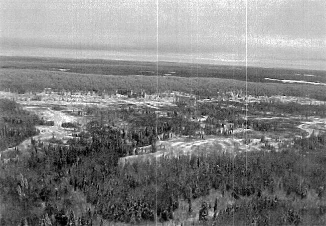
The most unique feature within the site is an exposed bedrock ridge (106) running north to south and is dominated by jack pine stands (E03) and rock outcrops (106). There is also a regenerating stand (E02) running north south through the site between the jack pine ridge and Leacock Creek. This past harvest block also has a few islands of jack pine and black spruce that were left during operations and a number of trails and roads (T00). Harvesting activities occurred within the site in 1986, 1998 and 1999 (see map). A harvested jack pine stand bisects the site, as well, most of the northeastern section of the site was harvested in 1998.
The site’s small size, its location within a developed rural setting and the extensive disturbance present in most of the eastern section of the site severely limits the site’s ability to provide quality recreational experiences. However, some of the potential recreational activities that could be associated with the site include berry picking (g02), hunting (h00), ATV use (t01), snowmobiling (d10) and hiking (t08).
Some of the sensitive features within the site could be affected by recreational use and resource development. These features would include the regenerating stands (E02), the wetland ecosystems (E08) of alder, willow and meadow marshlands associated with Leacock Creek and western boundary that follows Wabi Creek as well as the jack pine stands «E03) located on the rock ridge outcrop (106). All these features and the potential for rehabilitation should be given consideration during future planning.
End
Ontario’s Living Legacy C1623 - Henwood Township Forest and Wetland Lacustrine
Enlarge Henwood Township Forest and Wetland Lacustrine map
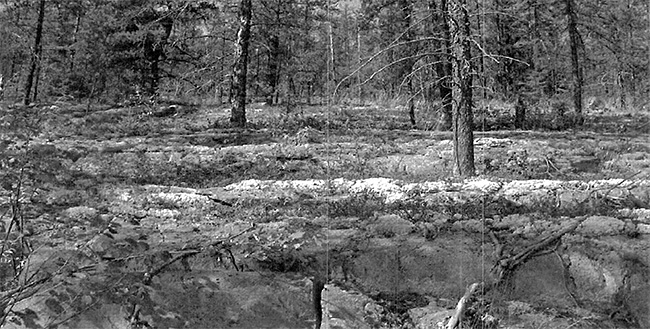
Exposed bedrock ridge located in central portion of the site. Photo taken by William Foy, 2001.
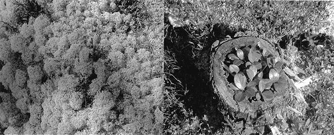
Left photo: Coral Lichen (Cladina stellaris) growing along the rock ridge. Photo taken by William Foy, 2001.
Right photo: Wintergreen (Gaultheria procumbens) growing along the rock ridge. Photo taken by William Foy, 2001.
Bear cub seen in birch tree during ground visit. Photo taken by William Foy, 2001.
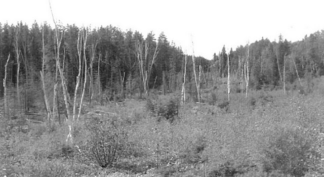
Area where timber harvesting has occurred. Regeneration can be seen between the White Birch trees. Photo taken by William Foy, 2001.
Appendix #4 - Procedural guideline B - Land Uses - Test of Compatibility (PL Procedure 3.03.05)
Procedural Guideline B - Land Uses - Test of Procedure
The Conservation Reserve policy provides broad direction with regard to the permitted uses. The policy provides an indication of the variety of uses that will be considered acceptable in Conservation Reserves. The only caution is that "any new uses, and commercial activities associated with them, will be considered on a case by case basis, and, they must pass a test of to be acceptable."
What does a "test of compatibility" mean? An examination of this must start from the premise of why an area is set aside - specifically, its representative natural heritage values. Criteria are then identified to guide compatibility considerations. These criteria apply to the long-term acceptability of both existing uses and new uses.
-
Conformity to SCI/RMP: SCI describe values for which an area has been set aside and the range of appropriate uses that will be permitted in the area. SCI may also speak to the acceptability of other 'new' uses currently not occurring in the area.
The first 'test' is:
do proposed new land uses and/or commercial activities conform to the direction of the SCI/RMP for the conservation reserve? Would the new use(s) depart from the spirit of appropriate indicator land uses in the SCI/RMP?
- Impact Assessment: If the proposed use(s) pass test 1 it is important to determine their impact on the area before they are approved. This should include the following:
- Impact on natural heritage values:
will the new use(s) impact any natural values in the area? If so how and to what degree? Is it tolerable?
- Impact on cultural values:
will the new use(s) impact an historical or archaeological values in the area?
- Impact on research activities:
will the new use(s) affect research activities in the area?
- Impact on current uses:
will the new use(s) have any negative impact on the array of current uses?
- Impact on area administration:
will the new use(s) increase administrative costs and/or complexity?
(For example, the cost of area monitoring, security and enforcement). - Impact on accommodating the use outside the conservation reserve:
Could the use(s) be accommodated as well or better outside the conservation reserve?
- Impact on socio-economics of the area:
will the new use(s) affect the community(ies) surrounding the area in a positive or negative way?
(For example, will the new use make an area less remote thereby affecting a local tourism industry that is dependent on the area’s remoteness for its appeal?) - Impact on area accessibility:
does the new use(s) give someone exclusive rights to the area or a portion of the area to the exclusion of other existing uses?
- Impact on natural heritage values:
Appendix #5 - Procedural guideline C
Research activities in conservation reserves
Purpose
To encourage contributions to the goal of conservation reserves by:
- Providing direction for research activities associated with conservation reserves: and
- Establishing a process for the review and approval of proposals by researchers, which could have an impact on the values protected by the conservation reserve.
Definition
Research means any investigation or study of the natural, cultural, social, economic, management or other features of characteristics of conservation reserves.
Guidelines
Research will be encouraged to provide a better understanding of the natural values protected by a conservation reserve and to advance their protection, planning and management. The Statement of Conservation Interest will define, for each conservation reserve, the key research issues, set out the parameters within which research may occur and identify research needs.
Applications and approvals
Researchers must apply in writing to the Area Supervisor for permission to conduct research. The request letter must contain a statement explaining why the proposed research should be undertaken in the particular conservation reserve in preference to another location.
Proposals will be reviewed and approved by the Area Supervisor, guided by the Statement of Conservation Interest prepared for each reserve (see Guideline A Resource Management Planning) and using Guideline B Land Uses - Test of Compatibility. Permission must be granted in writing, including any conditions to be met in conducting the research, prior to the undertaking of any research project.
Terms and conditions
Permission to conduct research under this policy will be valid for a period of 12 consecutive months from date of issue. Permission to continue a research project for additional periods of 12 months or less may be granted upon submission of a written request and progress report. The Ministry may require the posting of collateral to assure that the terms and conditions of granting pem1ission are met.
The Area Supervisor may suspend or revoke permission at any time for failure on the part of the researcher to meet:
- The intent or conditions of this policy.
- The requirements under the Public Lands Act, including all amendments, where applicable.
- The requirements under any other Act or Regulations or Ontario or Canada, including those governing the taking, handling, storing, confining, trapping, excavating and marketing any specimen, artifact, information or action (for example, scientific collector’s permit).
- The conditions and agreements specified in granting permission.
Final report
The researcher will submit copies of reports, publications and theses following from the results of the project to the Area Supervisor.
Appendix #6 - Indicator uses for conservation reserves
Industrial activities
| Activity | Generic OLL policy - existing | Generic OLL Policy - new | Specific application - existing | Specific application - new |
|---|---|---|---|---|
| Commercial timber | No | No | No | No |
| Cutting of trees by leaseholders and adjacent property owners for fuelwood and small-scale uses | Maybe | Maybe | No | No |
| Timber salvage/sunken | Maybe | Maybe | No | No |
| Mineral exploration | Maybe | Maybe | No | No |
| Mining | No | No | No | No |
| Extraction of peat, soil, aggregate, other materials | No | No | No | No |
| Forest renewal | Maybe2 | Maybe2 | Maybe2 | Maybe2 |
| Hydro power generation | No | No | No | No |
| Communication corridors | Yes | No3 | N/A | No |
| Energy transmission corridors | Yes | No3 | N/A | No |
| Transportation corridors | Yes | No3 | N/A | No |
| Resource access roads | Maybe3 | Maybe3 | Yes | No |
| Private access roads | Yes | No3 | Yes | No |
Recreation activities
| Activity | Generic OLL policy - existing | Generic OLL Policy - new | Specific application - existing | Specific application - new |
|---|---|---|---|---|
| Sport fishing | Yes | Yes | Yes | Yes |
| Sport hunting | Yes | Yes | Yes | Yes |
| Facility development | Maybe | Maybe | N/A | Maybe6 |
| Non-trail snowmobiling | Maybe5 | Maybe5 | No55 | No55 |
| Non-trail ATV use | Maybe5 | Maybe5 | No55 | No55 |
| Motorized boating | Yes | Yes | Yes | Yes |
| Camping | Maybe | Maybe | Yes | Yes |
| Trails: hiking, snowmobiling, cycling, horse riding and cross-country skiing | Yes | Maybe | Yes | Maybe6 |
| Private recreation camps | Yes6 | No | N/A | No |
Commercial activities
| Activity | Generic OLL policy - existing | Generic OLL Policy - new | Specific application - existing | Specific application - new |
|---|---|---|---|---|
| Fishing | Yes7 | Maybe | N/A | No |
| Bait-fish harvesting | Yes7 | Maybe | Yes | Yes |
| Commercial fur trapping | Yes7 | Maybe | Yes | Yes |
| Trapping cabin | Yes | No | Yes | No |
| Out-post camps/tourism facilities | Maybe9 | Maybe9 | N/A | No |
| Commercial bear hunting (tourist operators) | Yes | No | Yes | No |
| Wild rice harvesting | Yes8 | Maybe | N/A | No |
| Food harvesting | Maybe | Maybe | N/A | No |
Resource management activities
| Activity | Generic OLL policy - existing | Generic OLL Policy - new | Specific application - existing | Specific application - new |
|---|---|---|---|---|
| Resource inventorying | Yes | Yes | Yes | Yes |
| Resource monitoring | Yes | Yes | Yes | Yes |
| Fire protection | Yes | Yes | Yes | Yes |
| Insect and disease | Maybe | Maybe | Maybe | Maybe |
| Featured species management | Maybe | Maybe | Maybe | Maybe |
Other activities
| Activity | Generic OLL policy - existing | Generic OLL Policy - new | Specific application - existing | Specific application - new |
|---|---|---|---|---|
| Research | Yes | Yes | Yes | Yes |
| Collecting | Maybe10 | Maybe10 | Maybe10 | Maybe10 |
| Food gathering | Yes | Yes | Yes | Yes |
| Land disposition | Yes11 | Maybe11 | N/A | No |
| Habitat management for wildlife | Maybe12 | Maybe12 | Maybe | Maybe12 |
Notes:
2In the recently harvested area renewal can be conducted where it will be of net benefit to the protected area and to, the greatest extent possible, it should be designed to replicate natural conditions.
3The intent is to actively discourage these uses, but it is recognized that in some circumstances these will be no alternative: this will be determined through planning.
4New private access roads, including additions to existing roads, will not be permitted except where there are previous commitments that were made prior to March 29, 1999. Such commitments will be subject to the completion of a public planning process.
5Use permitted for the direct retrieval of game only.
6Only permitted after test of compatibility and amendment to SCI.
7Existing private recreation camps are eligible for enhanced tenure but not for the purchase of lands. A decision to grant enhanced tenure, or to transfer recreational camps will be addressed through a screening process.
8Existing use permitted to continue, unless there are significant demonstrated conflicts. New operations can be considered, subject to the "test of compatibility" without an amendment to SCI.
9Existing authorized tourism facilities can continue unless there are demonstrated conflicts. The operators of tourism facilities can apply to upgrade tenure from land use permit (LUP) to lease. New tourism facilities can be considered during planning for a conservation reserve.
10Must be part of an authorized research project.
11Sale of lands is not permitted with the exception of some minor types of dispositions where it does not detrimentally affect the values an area is intended to protect. Renewals of existing leases or LUPs are permitted. Requests for transfer of tenure will be considered in the context of the SCI. New leases or land use permits will be allowed for approved activities.
12A specific policy was not identified in the LUS, although specific management prescriptions will be identified in the context of an SCI.
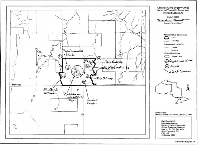
Appendix #7 - Maps
Kirkland Lake Henwood Township Forest & Wetland Conservation Reserve Bryce & Cane Wetland Lacustrine Conservation Reserve
Footnotes
- footnote[1] Back to paragraph Gap analysis, in conservation biology terms, is an approach or method for setting and filling natural heritage targets. The process helps identify features that are under-represented within the natural heritage areas system. A number of different approaches can be taken; however, they all try and assess features that may require conservation.
- footnote[2] Back to paragraph Tall Shrub Shoreline Fen: Fen areas are peatlands with water table at or above the surface with very slow water movement through communities via seepage that results in a more mineral, nutrient and oxygenrich environment than bogs. Tall shrub shoreline fens; water regimes are saturated or seasonally flooded and contain shrubs typically 1.5 to 3 m tall with hummocks with Sphagnum and ericaceous shrubs (i.e. shrubs from the family Ericaceae). Indicator plants include; speckled alder (Alnus incana), dwarf birch and willows species (Harris et al. 1996).
- footnote[3] Back to paragraph Meadow marshes are generally permanently or seasonally flooded wetlands with emergent vegetation cover greater than 25%. Often associated with beaver activity.
- footnote[4] Back to paragraph All working group ages give are corrected to 2002.