John E. Pearce Provincial Park Management Plan
This document provides policy direction for the protection, development and management of John E. Pearce Provincial Park and its resources.
Approval statement
I am pleased to approve the John E. Pearce Provincial Nature Reserve Management Plan as official policy for the management and development of this park.
This management plan reflects this Ministry’s intent to protect the natural features of John E. Pearce Provincial Nature Reserve and to maintain and' develop high quality opportunities for heritage and nature appreciation for residents of Ontario and visitors to the province.
Signed,
D. J. Johnstone
Regional Director
Southern Region
1.0 Introduction
John E. Pearce Provincial Park exists today as a reminder of Elgin County’s heritage. It represents a most generous gift to the people of Ontario by the gentleman after whom it is named. Mr. Pearce was anxious to have the assurance that the woodlot, which has been managed by many generations since the earliest colonial days, be preserved to benefit future generations of Canadians.
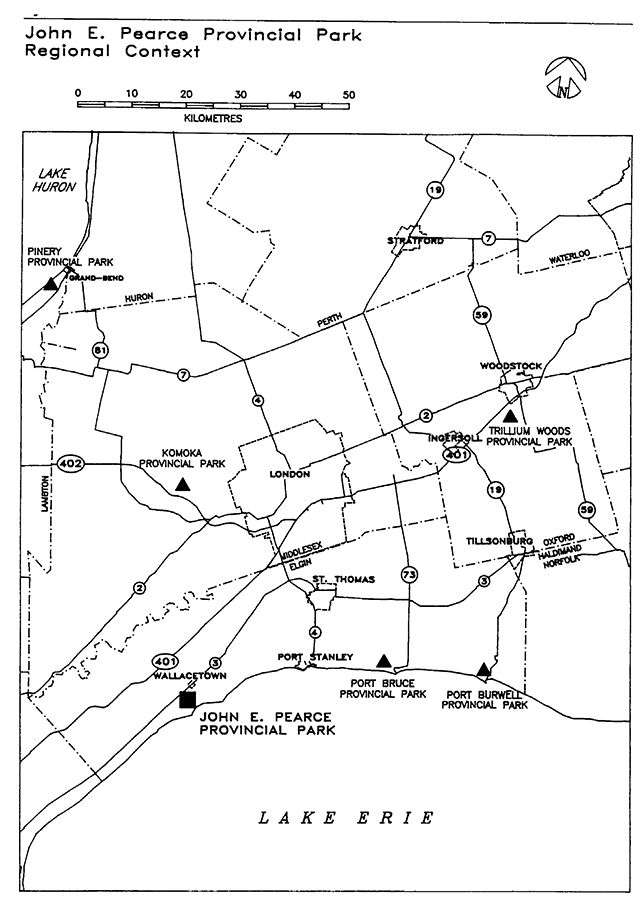
John E. Pearce Provincial Park is located on the shores of Lake Erie approximately 2 kilometres south of Wallacetown off Highway No. 3 in the Township of Dunwich, County of Elgin (Figure 1).
Development of the park began in 1956 when Mr. John E. Pearce donated 11.7 hectares (28.88 acres) of land to the Province of Ontario. This property had been held by his family since it was first settled in 1809. To commemorate this gift an inscribed stone monument was erected in the park.
This original area was established as John E. Pearce Provincial Park by Ontario Regulation 144/57 dated June 20, 1957. With the subsequent acquisition of adjacent land, the area of the park was expanded to 67.9 hectares (167.71 acres).
John E. Pearce Provincial Park offers a day use picnicking area with a scenic view of Lake Erie. The park’s beach area is narrow and inaccessible because the bluffs along the lakeshore rise to approximately 30 metres in height. Most of the park supports a relatively undisturbed climax hardwood forest while one third of the park area is presently leased and under active cultivation.
The purpose of this management plan is to establish detailed policy guidelines for the park’s long term protection, development and management. The plan will be reviewed in 10 years or sooner if required.
It will define the role and significance of the park in the ministry’s provincial park system and provide statements of policy for the planning, management, operation and development of the park’s resources. These policies must be responsive to public interest and compatible with protection of the environment.
2.0 Summary of issues
With the approval of this management plan, the John E. Pearce Provincial Park has been reclassified from a natural environment class park to a nature reserve to more appropriately recogniz.e the heritage aspects and earth and life science characteristics found there (Section 3.1).
The farm property, which includes a midnineteenth century Georgian style house, was originally acquired to permit development of a recreational camping area. As demonstrated through the Aylmer District land use planning process, there are ample camping facilities with better access to the Lake Erie shoreline provided by other agencies and the private sector.
The 22.3 hectares of agricultural land is currently farmed under a lease agreement. Intensive agriculture practices are not permitted in nature reserves.
It was recommended in the preliminary plan that the dwelling and farm property be removed from the regulated area of the park and that the park boundary be amended accordingly. Methods of protecting the house by heritage easement will be investigated prior to any disposal of the dwelling property. As a result of the public input, the agricultural land will be retained. This will allow re-establishment of a woodlot on the north side of the road. This will be accomplished on a progressive basis as funding permits. Vegetation management plans will be produced as required.
The constant erosion at the base of the bluff by wave action causes the bank to fall away and makes the top of the bluff unstable. The fence along the bluff and the warning signs will be maintained for public safety (Section 4.3 and 6.0).
The possibility of creating a new parking area parallel to the Lake Road east of the present entrance has been considered. This would allow maintenance of existing lanes as pedestrian paths, simplify maintenance and reduce vandalism. Nature viewing and recreation would be enhanced.
The disadvantages would be a 300 metre walk for visitors and the restriction of staff access to the park. A questionnaire revealed that two thirds of visitors were in favour of closing the access road However, it is felt that the benefits would not outweigh the disadvantages to visitors so it is proposed that the parking and road access remain as it is at present.
3.0 Park policies
3.1 Classification
John E. Pearce Park was classified as a natural environment park within the classification system for provincial parks. Natural environment parks incorporate outstanding recreational landscapes with representative natural features and historical resources to provide high quality recreational and educational experiences.
With the approval of this plan the John E. Pearce Provincial Park is reclassified from a natural environment park to a nature reserve park (Section 2). Nature reserves are areas selected to represent the distinctive natural habitats and landforms of the Province, and are protected for educational purposes and as gene pools for research to benefit present and future generations.
This park incorporates a sample of the eroding Lake Erie bluffs in association with deciduous forest. Representation of these features on Lake Erie does not occur elsewhere within the provincial park system. The park also provides a link with the history of the local area (Section 3.3.2) and permits limited day-use recreational opportunities.
This reclassification reflects a refocussing of priorities in the management of the park. The change in emphasis of park management would be from maintenance of a day use recreational feature having a pleasant natural environment to long term stewardship and protection of a significant representative natural area. The current limited amount of recreation associated with nature and heritage appreciation will continue to occur.
3.2 Goal
To protect a representative sample of the Lake Erie shoreline hardwood forest. To provide limited day-use recreation opportunities and to maintain an environment in relation to the local history of the surrounding area/
The lakeshore and the hardwood forest environment is characteristic of Site Region 7-2, the Deciduous Forest Region and the Carolinian Zone of Canada. It will receive protection by re-designating John E. Pearce Provincial Park as a nature reserve.
Public access to view the Lake Erie shoreline and the bluffs is limited because most land along the shore is privately owned. The nature reserve provides the public with these viewing opportunities.
The features of local historical interest are St. Peter’s Anglican Church, Tyrconnell, which is east of the park, and the Talbot Trail. The Talbot Trail is a tourist route extending from Windsor to Fort Erie through the incorporation of existing provincial highways and county roads. The park area was part of the original Talbot Settlement and was acquired from Colonel Talbot by a direct relative of the Pearce family in 1809.
Prior to the white man’s arrival this area was also used as an Iroquoian Indian encampment. Numerous middens were discovered and there was evidence of several longhouses. Ceramics and artifacts were also unearthed. These date back to approximately 1400 AD.
3.3 Objectives
John E. Pearce Provincial Park will contribute to the objectives of the Ontario Provincial Park system in the following manner:
3.3.1 Protection
To protect provincially significant elements of the natural and cultural landscape of Ontario.
The Lake Erie shoreline between Port Talbot and Tyrconnell includes one of North America’s most impressive sequences of glacial sediments. The John E. Pearce Provincial Park is a natural observation area for the interpretation of this feature.
The park is an excellent example of bluff erosion caused by repeated desiccation and wetting. This is characteristic of this portion of the Lake Erie shoreline.
Six vegetation types, including 15 community complexes were identified in the park. Upland and lowland deciduous forests provide excellent examples of Carolinian (Deciduous Forest) vegetation. Despite the small size of the park, plant diversity was found to be high due to the variety of habitats and the fact that there tend to be more species present in Southern Ontario compared to areas of similar size in more northern localities.
Of the 405 species of plants found in the park, 15 are considered to be rare in Ontario. Most rare species are Carolinian in origin, with the exception of the sedge Carex radiata, which has an Appalachian distribution.
3.3.2 Heritage appreciation
To provide opportunities for exploration and appreciation of the outdoor natural and cultural heritage of Ontario.
The park’s most striking feature in summer is its greenery. The driveway and walkways meander through one of the finest mixed hardwood forests in Southwestern Ontario. Some of the trees are over 200 years old. Within the confines of the woodlot the most predominant tree is the sugar maple. Walnut, ash, hickory, ironwood and beech trees are also dispersed throughout the park. Covering the forest floor is a lush mat of plants and wild flowers. As one wanders along the trails, trilliums, hepaticas, touchme-nots, violets, jack-in-the-pulpits and blood roots can be seen blooming in their respective seasons.
With the advent of the autumn season visitors have the opportunity to witness the annual hawk migration. The birds of prey travel south each year following the Lake Erie shoreline to the United States. From vantage points along the bluff in the park, bird watchers can observe the raptors perform aerial acrobatics on warm air currents.
The Port Stanley till is exposed in the 21 to 30 metre bluffs and gullies at the park. It is a silty clay till, but the Port Stanley drift is often interbedded with varved lacustrine silt and clay and some waterlaid till, all originating during the Port Bruce stadia!, the last major thrust of the Erie lobe in this part of Ontario.
The example of bluff erosion in John E. Pearce Provincial Park is a regionally significant earth science feature caused by repeated desiccation and wetting of the Lake Erie shoreline.
The surrounding area is associated with the historically significant Talbot settlement. Colonel Thomas Talbot began the formal settlement in the Township of Dunwich in 1803. The original log residence occupied by Colonel Thomas Talbot was located only a few miles from the park.
St. Peter’s Anglican Church, which adjoins the park boundary, was built in 1827 by local settlers attracted to the area by Talbot’s settlement initiatives. The church has been used for services continuously since that time and the church cemetery is the burial place of Colonel Talbot.
The Lake Road which divides the park leads to the Talbot Trail, Lake Erie’s historic highway.
This area has produced evidence of a Iroquoian Indian encampment. Ceramics and artifacts dating back to 1400 AD were also unearthed.
3.3.3 Recreation and tourism
To provide provincial park day-use recreation opportunities and to provide residents and out-of-province visitors with opportunities to discover and experience the distinctive environment of the park and surrounding area.
The recreational opportunities at John E. Pearce Provincial Park are limited to day-use activities such as picnicking, walking and bird-watching.
Land along the Lake Erie shoreline is mostly privately owned thereby limiting public access. The park provides access to the bluffs overlooking Lake Erie. Visitors enjoy viewing the lake, the shoreline bluffs and the evidence of erosion. The park is one of the few areas between Port Stanley and Port Glasgow providing public access to the shoreline.
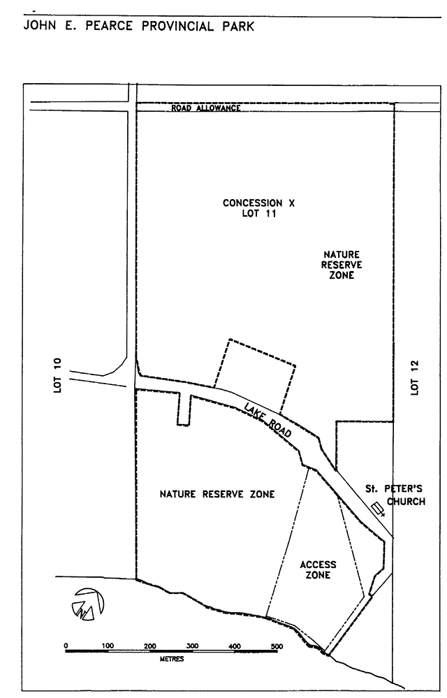
3.4 Park boundary
The park presently extends over 67.9 hectares (Figure 2). Currently 22.3 hectares of this area is used for agricultural purposes under a lease agreement. The County of Elgin purchased .4 hectares (1 acre) along County Road #8.
Originally it was thought that the agricultural lands might serve as a future site for recreational facility development. However, as demonstrated through the Aylmer District land use planning process there is an ample supply of camping facilities provided by other agencies and the private sector along the Lake Erie shoreline. Generally those areas provide better access to the lake for water based recreation.
John E. Pearce Provincial Park has been reclassified from a natural environment class park to a nature reserve to more appropriately recognize the heritage aspects and earth and life science characteristics found there (Section 3.1).
Intensive agriculture practices are not permitted in nature reserves. The park boundary will be amended to exclude the farm house. The agricultural land will be retained and planted as funding permits (Figure 2, Section 2).
The building has local historical significance but does not contribute to the goals and objectives of the provincial park system. The ministry will investigate the various methods that are available to protect and restore the house.
3.5 Park zoning
Three zones have been designated for managing the nature reserve park: two nature reserve zones and one access zone (Figure 2).
3.5.1 Nature Reserve Zone
The nature reserve zones have been established to protect the forested areas of the park and the shorecliffs as well as the agricultural land that will be progressively planted. These zones contain a diversity of forest habitat communities. Four hundred and five plant species have been identified in the park, three of which have not been previously recorded elsewhere within Elgin County. A total of 15 provincially rare plants have also been recorded.
The forests are representative of the Deciduous Forest Region. Undisturbed climax forests, such as those found south of the Lake Road in John E. Pearce Provincial Nature Reserve, are no longer common in southern Ontario.
The two nature reserve zones, one each on either side of the Lake Road will be managed to retain, restore and replace the undisturbed climax condition of these forests.
3.5.2 Access zone
The access zone contains 5 hectares of land and provides access to the park. The road into the park is located in this zone and leads to the day-use area, the John E. Pearce monument and the lakeshore bluffs viewing area.
4.0 Resource management
The park will be managed in accordance with the general planning and management policies for nature reserve class Provincial Parks as outlined in the Ontario Provincial Parks Planning and Management Policies. Additional policies, where needed to meet requirements specific to John E. Pearce Provincial Park are provided in the following sections.
Planning and management of the park will recognize that these policies are interrelated and that an integrated approach will be required in order to achieve the objectives for this park.
4.1 Vegetation
For the most part, climax forests require very little management since they are self-sustaining if left undisturbed. For this reason, no active management is proposed for the nature reserve zone on the south side of the road. Successional vegetation management will be practiced. A vegetation management strategy will be prepared if active management is proposed for the area on the south side of the road.
The agricultural land on the north side of the road will be progressively planted in trees and natural meadows as funding permits. Vegetation management plans will be produced as required to guide this restoration initiative.
No change in mowing of lawns or general park maintenance is recommended. The lawn at the southern end of the park is used by picnickers and might otherwise cause needless trampling of vegetation in wooded areas if the lawn were removed (see Section 4.3, Shoreline Bluffs).
Care will be taken to avoid future development on areas where rare plants occur.
It is unfortunate that the introduced species black locust (Robinia pseudo-acacia) was planted in the gully. To remove these trees would probably cause further erosion of the gully and this would be more damaging than allowing them to remain.
If future erosion problems persist in the gully, native species should be used to reduce substrate erosion. Native species on site, such as the shrub soapberry (Shepherdia canadensis), stiff gentia (Gentiana quinquefolia) and Canada bluegrass (fua compressa) should be used for erosion control on exposed slopes.
All fires will be suppressed using standard methods and techniques where values in the park or on adjacent private lands are at risk.
Insect populations and diseases may be controlled, if feasible, where park features or those on adjacent lands are threatened. Where control measures are desirable they will be directed as narrowly as possible to the specific insect or disease so as to have minimal effects on other components of the environment of the park.
Adjacent to the park road, along walking trails and in the day use area hazardous tree limbs shall be pruned and if necessary, trees removed for the safety of park visitors.
If it becomes obvious that visitor pressure within the nature reserve zones is causing trampling of areas containing rare species then walking trails and sign systems may be established to mitigate such damage. Location of the trails will be guided by the report The Flora, Vegetation and Fauna of John E. Pearce Provincial Park prepared by Jocelyn M Webber.
4.2 Wildlife
Protection of the Carolinian vegetation will ensure continuation of wildlife species that inhabit the park.
4.3 Shoreline bluffs
The erosion of the bluffs will be left unchecked. However, for public safety, warning signs regarding the hazards associated with the bluffs have been placed in the day use area and along the walking trail.
In addition, the fencing will be maintained to mark how close visitors can safely approach the edge of the bluff. The fencing and the signs should discourage them from venturing too near. As erosion continues the fence will be moved inland with appropriate grasses areas provided for picnicking.
4.4 Archeology
During a preliminary archaeological survey of the park, locations were identified that contained early Iroquoian artifacts. These sites will be protected by not identifying their locations in the park and by ensuring that no disturbance of the sites occur.
4.5 Hunting and trapping
Sport hunting and commercial trapping are not permitted in the park.
4.6 Fishing
There are no fishing opportunities in the park.
4.7 Motorized Vehicles
Snowmobiles and all terrain vehicles are prohibited.
5.0 Client services
5.1 Visitor services
The self use visitor services program will provide an appreciation for the park as a nature reserve and an awareness of the park for its local cultural value.
A self-use information and interpretive sign system will be put in place to orient the park visitor to the facilities available and to inform the visitor about the natural and cultural values found in the nature reserve and surrounding area.
5.1.1 Information
Information will be provided by a park brochure, signs and exhibits. A park leaflet has been produced for general distribution through other parks, tourist information centres and other locations.
5.1.2 Interpretation
The office of the Superintendent of Port Burwell Provincial Park, upon request from groups, will provide assistance in the interpretation of the natural and cultural values of the nature reserve.
5.1.3 Outdoor recreation
The park road and walking trails will be upgraded and maintained. Walking, picnicking and nature appreciation will be encouraged. There are excellent opportunities for viewing migratory and breeding birds.
Walking trails on the north side of the Lake Road may be developed in the future, at which time parking, access and visitor safety will be addressed.
5.2 Research
Scientific research by qualified individuals, which contributes to knowledge of natural and cultural values and to the management of the natural landscape will be encouraged. All research programs will require the prior approval of the Ministry of Natural Resources and must also meet any requirements under applicable provincial and federal legislation.
5.3 Marketing
Use of the park will be promoted through publications, personal contact and presentations to client groups. Promotional activities will occur by making the park leaflet available for use in other provincial parks, private campgrounds and tourist information offices as well as producing suitable articles for tourism publications in Elgin County.
6.0 Development
The existing fence along the bluff will be maintained for public safety. The constant erosion at the base of the bluff by wave action causes the bank to fall away and makes the top of the bluff unstable. The fence encourages visitors to stay back from the edge of the bluff. Warning signs will also be maintained.
The walking trails in the park will be upgraded to allow visitors self-guided interpretive opportunities in the nature reserve. Walking trails on the north side of the Lake Road may be developed in the future, as funding permits. If this occurs, parking, access and visitor safety will be addressed at that time.
The road, parking area, and facilities such as the vault privies in the day use area of the park will be maintained for the convenience of park visitors. As funds become available the park boundary will be fenced along roadways.
7.0 Public consultation
The public in the local area have been notified that a management plan has been prepared for John E. Pearce Provincial Nature Reserve. Additional copies of this plan are available at that office and at the Township of Dunwich office located in the town of Dutton.
Copies of the draft plan along with the invitation to comment on the plan was sent to the local municipalities, conservation authorities, adjacent landowners, interested organizations, groups and individuals.
A public open house was held on April 7, 1993. Approximately 50 people attended the session and over 20 written comments were submitted.
Many did not support the proposal in the preliminary plan to adjust the park boundary to exclude the house and farm land. The Ministry of Natural Resources has recognized that the farm land has the potential to contribute significantly to the value of the nature reserve. This land will be retained and progressively replanted. Vegetation Management Plans will be prepared as required.
The Ministry is believes that removing the dwelling from the park by adjusting the park boundary is consistent with achieve park goals and objectives. A heritage easement will be arranged in order to afford the house the protection that it deserves.
8.0 Selected references
Harvey, E. T. 1977. John E. Pearce/Earth Science Inventory Checklist. Ontario Ministry of Natural Resources, Southwestern Region. 4p.
Ontario Ministry of Natural Resources. 1978. Ontario Provincial Parks Planning and Management Policies.
Ontario Ministry of Natural Resources, Southwestern Region. 1979. Day Use and Camping Attendance Characteristics at Provincial Parks in the Southwestern Region.
Ontario Ministry of Natural Resources, Southwestern Region. 1991. Southwestern Region Visitor Services Strategy.
Ontario Ministry of Natural Resources, Parks and Recreational Areas Branch. 1980. 1979 Day Visitor Summary Statistical Report.
Ontario Ministry of Natural Resources, Parks and Recreational Areas Branch. 1983. 1983 Provincial Park Day-User Survey Summary Statistical Report.
Ontario Ministry of Natural Resources. 1985. Provincial Operating Standards Manual for Ontario Provincial Parks.
Ontario Provincial Parks Act. Revised Statutes of Ontario 1980. Chapter 822.
Webber, Jocelyn M 1982. The Flora, Vegetation and Fauna of John E. Pearce Provincial Park. Ontario Ministry of Natural Resources, Southwestern Region
3915-1
(0.25 k P.K., 94 09 28)
ISBN 0-7778-2953-3