Magpie River Terraces Conservation Reserve Management Statement
This document provides policy direction for the protection, development and management of the Magpie River Terraces Conservation Reserve and its resources.
December 2004
Prepared by Tom Kenerknecht, R.P.F.
Approval statement
I am pleased to approve this Statement of Conservation Interest (SCI) for the Magpie River Terraces Conservation Reserve (C1520).
Direction for establishing, planning and managing Conservation Reserves is provided by the Public Lands Act and current policy. “Ontario’s network of natural heritage areas has been established to protect and conserve areas representative of the diversity of the natural regions of the province, including species, habitats, features and ecological systems which comprise that natural diversity” (OMNR, 1997). This SCI will provide guidance for the management of the Conservation Reserveand the basis for the ongoing monitoring of activities. More detailed direction at this time is not anticipated. Should significant facility development be considered or complex issues arise requiring more defined management direction, a more detailed Resource Management Plan will be prepared with full public consultation. This document was prepared with input from Wawa District staff, other ministries, and the public. A draft plan was provided to the MNR Northeast Region planning unit for review.
The public was consulted on potential boundary refinement prior to the CR being regulated. During plan preparation the general public has an opportunity to review and comment on proposals in the draft plan before plan approval. Technical and scientific advice and expertise was obtained as required throughout the planning process. The Conservation Reserve will be managed under the jurisdiction of the Wawa Area Supervisor of the Ministry of Natural Resources, Wawa District.
Original signed by Terry Taylor
District Manager
Recommendation for approval
Date: February 25, 2005
Approved by
Original signed by Rob Galloway
Regional Director, Northeast Region
Date: April 10, 2005
1.0 Introduction
As reflected in its Statement of Environmental Values, key objectives of the Ministry of Natural Resources include ensuring the long term health of ecosystems, protecting natural heritage and biological features of provincial significance, and leaving future generations a legacy of the natural wealth that we still enjoy today. A key strategy in achieving these objectives is the establishment and management of a network of protected areas that reflect the spectrum of the province’s natural diversity.
The purpose of this Statement of Conservation Interest (SCI) is to manage the Magpie River Terraces Conservation Reserve in accordance with these objectives. Specifically, the SCI describes the site and its main natural and cultural features, and outlines future management to protect and/or restore its resources. Potential uses and activities of the Reserve are discussed and restrictions on human activity are prescribed if and when appropriate. This SCI is prepared in accordance with Procedure PL 3.03.05. Since there are no major land use decisions to be made or contentious issues to be resolved, this will be a basic SCI. As this is a custodial document, a Registry Proposal File does not need to be posted on the Environmental Registry.
The planning area for this SCI is the regulated boundary of the Conservation Reserve (CR) as shown on map 1. However, in a larger context, the Reserve cannot be managed in isolation. For example, it will influence and be influenced by the surrounding lands and waters. Similarly, as part of the larger parks and protected areas system, it will contribute to the achievement of provincial, national and international targets, while at the same time being influenced by provincial legislation and the site is known locally as an area largely deforested by industrial pollution exacerbated by wildfire, and commonly called the ‘fume kill area’. This characteristic may make the site invaluable as a study area, as described more fully in section 6.4. Another very significant feature is the geology of the area, and the presence of spectacular terraces described more fully in section 4.1.2. The exposure of these terraces and other geological features by deforestation and erosion facilitates geological study and interpretation, and indeed the site is a popular destination for natural heritage appreciation. The Magpie River Terraces CR is located in the Wawa District of the Ministry of Natural Resources’ Northeast Region. It is within the boundaries of the Corporation of the Township of Michipicoten, and approximately 6 kilometres north east of the Michipicoten First Nation.
2.0 Goals and objectives
2.1 Goals of conservation reserves
The goal of Conservation Reserves is to protect natural heritage and cultural values on public lands while permitting compatible land use activities.
2.2 Objectives of Statement of Conservation Interest
2.2.1 Short term objectives
The short term objectives are:
- To identify the state of the resource with respect to natural heritage values and current land use activities for the Conservation Reserve
- To manage the Conservation Reserve to protect the integrity of its natural values via specific guidelines, strategies and prescriptions detailed in this plan
2.2.2 Long term objectives
The long term objectives are:
- To establish representation targets (e.g. future forest conditions) and validate the site as a potential scientific benchmark
- To identify research/client services, and marketing strategies
- To give direction to evaluate future new uses or economic ventures
3.0 Management planning
3.1 Planning context
3.1.1 Planning area
The planning area is defined as the regulated boundary of the Conservation Reserve as illustrated on map 1. There are no Forest Reserves in the site.
For purposes of management planning for other land uses, particularly for Forest Management Planning, the boundary of the Conservation Reserve itself will not be treated as a ‘value’. However, specific values or features near or along the boundary may need to be addressed in other planning documents to ensure their protection or enhancement.
3.1.2 Management planing context
The Magpie River Terraces CR was recommended as a Conservation Reserve in the 1999 Ontario’s Living Legacy Land Use Strategy, and was identified as Land Use Area C1520. The site was regulated as a conservation reserve on December 7, 2002. Upon regulation under Ontario Regulation 805/94, mining, commercial forest harvest, hydroelectric power development (see next paragraph for qualification), the extraction of aggregate and peat, and other industrial activities were legally prohibited.
The site’s status as a Living Legacy Conservation Reserve subjects the site to certain policies for new Conservation Res erves as outlined in Table 3 of the Ontario’s Living Legacy (OLL) Land Use Strategy. The Land Use Intent for the CR, as outlined in Appendix A of the strategy treats the existing hydro operations as a non-conforming use which will be permitted to continue. Provincial policies for Conservation Reserves also apply to the Magpie River Terraces CR. Management Direction, including permitted uses, from the above and other sources, is summarized in the Ministry of Natural Resources Crown Land Use Atlas. Consistent with policy, new and future uses of the Conservation Reserve must be considered via a Test of Compatibility (Appendix 1). Certain uses or activities may also be subject to Environmental Assessment Requirements.
Because of the area’s deforested condition, and high sulphur content of the soil, the Magpie River Terraces has annually been designated as a Restricted Fire Zone under the Forest Fire Prevention Act.
3.2 Planning process
Because of the area’s geological values, the Magpie Terraces were considered for ANSI (Areas of Natural and Scientific Interest) designation, and in 1983 an area generally corresponding to the CR’s regulated boundary was recommended as a candidate ANSI. The site was not formally designated as an ANSI, but during the preparation of Lands for Life and Ontario’s Living Legacy strategies, the site was proposed as a protected area in Options 4 and 5 of the Preliminary Land Use Options in March 1998. In July 1998, in the Draft Land Use Planning Recommendations for the Boreal East Planning Area, the Boreal East Roundtable recommended a Forest Preserve to protect the Magpie River Terraces. In March, 1999, the Ontario’s Living Legacy Proposed Land Use Strategy identified the Magpie Terraces area as a proposed protected area, C1520, intended for regulation as a Conservation Reserve. The site was again recommended as a Conservation Reserve in the approved Ontario’s Living Legacy Land Use Strategy. In late 1999 and early 2000, a public consultation process invited First Nations, industry and the general public to recommend refinements of the proposed boundary. No comments on the boundary were received and the site was regulated in December 2002. This Statement of Conservation Interest for the Magpie River Terraces is a Basic Statement of Conservation Interest. Because no contentious issues are expected to be addressed in the document, an Enhanced SCI or Resource Management Plan was not considered to be warranted. The public will be provided with an opportunity to comment on the recommendations in the draft SCI before plan approval.
The SCI does not propose new policy, and is therefore considered a custodial document. Consequently, an Environmental Bill of Rights Registry Proposal File will not be posted on the Environmental Registry.
The plan will be a working document, and amended if and when appropriate. Major decisions will be made with full public involvement opportunities.
4.0 Background information
4.1 Location and site description
4.1.1 Location
The Magpie River Terraces CR is within the Corporation of the Township of Michipicoten, and is approximately 6 kilometres northeast of the Michipicoten First Nation. It is in Chabanel and Bailloquet Townships in the Territorial District of Algoma. The Reserve is within the Wawa Area of the Ministry of Natural Resources’ Wawa District in the Northeast Region.
Map 1 shows the boundaries of the CR, and its regional setting.
4.1.2 Physical description
The Magpie Terraces CR, 2138 hectares in size, is accessible from the Steephill Falls Road and connecting roads which run from Highway 17 to Highway 101. The 10 distinct terraces resulted from dropping lake levels in the Superior Basin during the retreat of glaciation, and are the best developed and most dramatic terraces along the Canadian shore of Lake Superior. The Magpie River is located in 2BD tertiary watershed of the Lake Superior major basin. Hydroelectric power development occurs on the river, including a dam at Steephill. The Reserve straddles two forest sections and two forest regions. The northern section is in the Missinaibi-Cabonga section of the Boreal Forest, and the southern portion is in the Algoma section of the Great Lakes Forest Region. However, the area is not particularly typical of either section, and barren areas, low shrubs, and young white birch dominate much of the Reserve. Since the closure of Algoma Ore’s sinter plant in 1998, the area of total deforestation has decreased in size, and most of the site is beginning to revegetate. The CR is in Site District 3E5 (Foleyet) of Site Region 3E (Lake Abitibi). The forest climate type is mid-humid mid boreal. The influence of Lake Superior moderates climate compared to inland areas, and the prevailing westerly winds cause heavy snow cover. Four landform types are in the site: moderately broken ground moraine in the north portion of the north half; moderately broken outwash deposits in most of the south half and in pockets in the north half; strongly broken ground moraine in three pockets; and strongly broken outwash deposits in the south portion of the north half and in the east portion of the south half.
4.2 Administrative description
The Magpie River Terraces Conservation Reserve was regulated under the Public Lands Act on December 7, 2002. The regulated boundary is shown on Map 1.
The CR is under the administration of the Ministry of Natural Resources Wawa District in the Northeast Region.
The Reserve was in the Algoma Forest, held by Clergue Forest Management Inc. under Sustainable Forest Licence 542257, but was removed from the licence area prior to regulation. The site is within the Robinson Superior Treaty Area, signed in 1850 by Michipicoten Ojibway Chief Totomenai and the crown’s negotiator William Robinson.
4.3 History of the site
The details of Native occupation in the area remains uncertain, but some information is available. Between 8000 B.C. and 7000 BC, the retreat of the Laurentide Ice Sheet exposed the lands in the area. It is not known precisely when humans first occupied the newly exposed lands in what is now the Magpie River Terraces area, but by approximately 5500 B.C. Shield Archaic people lived in the general region (Harris 1987). By as early as 1165 B.C., there were four settlement areas on the Lake Superior coast just southeast of the terraces: one at Michipicoten Harbour, and three separate sites at the confluence of the Magpie and Michipicoten Rivers (Michipicoten Heritage Committee, 1992). These sites existed until 1894 A.D. when the Michipicoten people, and the original Indian Reserve at Michipicoten Harbour were displaced to the present Gros Cap Indian Reserve. Given the easy access to the Magpie Terraces area via the Magpie River, it is safe to speculate that the Magpie Terraces Area was used by the Michipicoten First Nation people. Being located at the confluence of two major travel routes (the Michipicoten/Missanabie route to James Bay, and the Great Lakes route), the Michipicoten people had widespread contact and trade. The expansion of the fur trade industry had a major influence on the local area and its native inhabitants. From at least 1725 until 1904, trading posts were operated at Michipicoten. (Macleod et al., 1972). The posts, at the confluence of two major trade routes, were important in the war between rivalling fur companies. By 1821, the Hudson’s Bay Company had achieved control of the fur trade in the Michipicoten area.
A major impact on the area was the emergence of the mining industry in the late 1800’s. In 1897, a brief gold rush began with the discovery of gold in the Wawa area. The gold boom waned by the early 20th century, but a more lasting impact came from the discovery of a major iron ore body in 1898, and the development of the Helen Mine. The mine, and associated development such as waterpower on the Magpie River and the construction of the Algoma Central Railway resulted in Wawa, and not the Michipicoten River Village becoming the economic hub of the area during the early 20th century. The mining industry saw several boom and bust cycles in the early 1900’s but in 1939, partly because of the impact of World War II and the need for arms, the Helen mine reopened. With the re-opening of the mine, a sintering plant was built just south of the present location of the Conservation Reserve. The sintering plant, which partially processed siderite ore for further processing at Algoma Steel in Sault Ste. Marie, emitted sulphur dioxide, and resulted in the “fume kill” area that includes the Conservation Reserve area. Repeated forest fires in the area exacerbated the situation, and the MNR has been designating the treeless area as a Restricted Fire Zone since 1972. The sintering plant ceased operations in 1998, and the treeless area has been noticeably “greening up”. The Magpie River Terraces is in an area of high mineral potential and numerous mining claims and patents surround the CR. Currently, the Terraces are a very popular and productive blueberry picking area, and provide a popular recreational pursuit in late summer.
The Steephill Falls (see map 2) was first developed for hydroelectric power generation in the early 20th century, and the original powerhouse operated from 1915 to 1926 (Great Lakes Power Limited, 2000). The old powerhouse still exists, and can be seen on the west side of the new Steephill Falls Generating Station, which began operation in 1990. The flooding of the Steephill Falls Reservoir resulted in excellent angling opportunities in the new waterbody. Part of the Algoma Central Railway was located in the CR, and have been removed, the railway bed still exists and provides an vehicular traffic. The railway bed remains under private ownership.
4.4 Inventories
The following table summarizes inventories, surveys, and reports completed for the Conservation Reserve. In addition, research is being conducted by agencies other than the MNR.
| Survey level | Earth Science | Life Science | Cultural | Recreational |
|---|---|---|---|---|
| Reconnaissance | Kor and Kristjansson, 2002 – Earth Science Summary – C1520 | Burkhardt, B. 2002. Life Science Checksheet, C1540 | Algoma Forest Cultural Heritage Sites (updated to 2005) and Algoma Forest Native Values Maps (2005) | Anderson, 2004 Recreation Resource Inventory Report |
| Detailed Requirement | None | None | N/A | None |
5.0 State of the resource (2005)
The Magpie River Conservation Reserve protects part of the Magpie Terraces, which represent the most dramatic and best developed terraces along the Canadian shore of Lake Superior. There are 10 distinct and expansive terraces representing dropping levels in the Superior Basin, from the Minong 9500 years ago to more recent post-glacial levels. As durable as these features are, human activity has impacted the Terraces. The mining of siderite ore to the south of the CR, including the Helen Mine near Moran Lake, left obvious visual evidence. The direct and indirect effects of sulphur dioxide emissions, and frequent fires have removed vegetation, which in turn has promoted severe erosion and exposed much of the area’s rock. The terraces are provincially significant, and the area is a popular and important area for geological study. The deforestation of most of the site has left the terraces sensitive to erosion from natural or human causes. For example, the scarp crest and scarp face of the terrace forms, especially when composed of sand, would be particularly sensitive to motorized traffic. Within the forested area, white birch dominates. Along the Magpie River, in moist and wet areas in the western section of the CR, black spruce and cedar are found. Jack pine and white spruce exist in more upland areas in the southwest portion of the Reserve. Despite being in the transitional zone between the Great Lakes and Boreal Forest Regions, the forested section includes few species typical of the Great Lakes Forest Region. Much of the Reserve has been deforested, and even the areas that are recovering after the closure of the sintering plant are predominantly barren and scattered young white birch and various shrub species. Consequently, the CR has not been interpreted for landform/vegetation combinations. However, the Reserve is known to be low in diversity, considering the size of the site. Evenness (the number of equally represented communities that control the vegetative nature of the site) is strongly skewed towards white birch.
The bedrock geology of the Reserve consists of: mafic to intermediate, metavolcanic rocks; felsic to intermediate metavolcanic rocks; and metasedimentary rocks of the Michipicoten greenstone belt, Wawa Subprovince, Superior Province. In the section west of the Magpie River, the CR is immediately underlain by areas of Bedrock Outcrop (Unit 1), Bedrock-Drift Complex (Unit 2ac), Ice-Contact Stratified Drift Deposits (Unit 4), Glaciofluvial Outwash Deposits (Unit 5), Alluvial Deposits (Unit 8g), and Organic Deposits (Unit 9). The section of the CR to the east of the river is immediately underlain by areas of Bedrock Outcrop (Unit 1), Bedrock-Drift Complex (Units 2a and 2bc), Glaciofluvial Outwash Deposits (Unit 5), Glaciolacustrine Deposits (Units 6f and 6a), Alluvial Deposits (Units 8a, 8b, and The Magpie Terraces CR was originally defined on the basis of the spectacular sequence of terraces, including at least 6 sets of paired terraces with a total relief exceeding 60 metres within the CR (Frey, 1987). The highest of the terraces occurs at an elevation of approximately 315 metres above sea level (Farrand and Drexler, 1985, Figure 4) roughly the present elevation of the isostatically uplifted shoreline of glacial Lake Minong in the area of the Conservation Reserve. The terraces are best developed between their occurrence at Josephine Creek in the upper portion of the CR, and their occurrence at Catfish Creek and Black Trout Creek in the lower portion of the Magpie River Valley. The horizontal continuity of the terraces is remarkable, especially in the lower portions of the Magpie River Valley below Steephill Falls.
The terraces provide spectacular scenery. The combination of rare geology and deforested condition make the site unique, and road access through the Reserve provides the public with outstanding viewing opportunities. The sensitivity of much of the site, especially to erosion and disturbance of shallow soil, require restrictions on trail and road building, and off-trail vehicle use (see section 5.7). The forested areas of the CR contain some overmature forest, as is fairly common in the area. The forest cover outside the deforested area appears typical of surrounding forest, and is not considered noteworthy. However the treeless area comprises 75% of the Reserve, and combined with hydro development of the river, and the bed of a former railway, the Conservation Reserve has been highly impacted by man. Despite the lack of tree cover, some large mammals including moose (in early winter) and bear are common. The most notable bird species in the Reserve is Sandhill cranes which nest in the area.
Soils in the area tend to be acidic, and the low levels of free carbonates provide little buffering capacity to acidic precipitation.
The boundaries of the Conservation Reserve include vectored boundaries. Many of the vectored boundaries, especially on the southern side, are necessary because of adjacent mining tenure. Mineral development activities near or adjacent to the CR could have significant impacts especially if a new mine is developed, adding to the Reserve’s already heavily impacted condition. Vectored boundaries in the northeast section are not adjacent to mining tenure. However, this section of the Conservation Reserve boundary is within the fume kill area, and thus forest operations will not occur in adjacent areas in the foreseeable future. Mineral exploration and development and exploration may occur in the future adjacent to any part of the CR. The treeless portion of the Magpie River Conservation Reserve has been in a Restricted Fire Zone (RFZ) since 1972. Despite this designation, numerous fires, the majority of which were caused by recreationists, have occurred. Successful suppression has minimized the impact of these fires, and the last major fire occurred in 1963, before the RFZ was in place. Fire has been and will be a major impact on the Reserve, particularly in exacerbating erosion. No known vulnerable, threatened or endangered species are known to exist on the site.
In summary, the Magpie River Terraces has experienced a great deal of impact from human activities. It has been impacted by airborne pollution and fires resulting in approximately 75% of the CR’s area being deforested. Past and current hydro development has impacted the river and shoreline, and created the Magpie Reservoir. The bed of the former Algoma Central Railway line still exists, and is still under private ownership. Off road vehicle use, owing to the Reserve’s open condition and proximity to the town of Wawa, presents a threat to sensitive soils and vegetation.
Despite the above impacts, the terraces remain a provincially ignificant feature. The removal of vegetation and the overburden has actually had some positive effects in exposing geological features, and in creating a unique and visually striking landscape.
5.1 Social/economic interest in area
The Magpie River has been developed for hydroelectric power, and since 1990, the Steephill Falls site has been generating electricity. The creation of the associated Magpie Reservoir has provided a popular angling and recreation area for tourists and local residents. The Magpie River is also a popular sport fishery and food source, containing brook trout, pike and walleye. The terraces are a popular destination for geological interpretation and study. As well, the unique scenery offers viewing opportunities accessible by road.
The Reserve is in a mineral development area, and several mines have been located south of the CR. Prospecting and advanced exploration continue outside the Conservation Reserve, and given the numerous mining claims and patents near or adjacent to the site, new mines could be developed.
Much of the site is covered by blueberries and during good crop years, the area is well used by both recreational and small-scale commercial pickers.
The Magpie River is a canoe route, although the Magpie Hydro development has impacted the river.
The Conservation Reserve is wholly within the Corporation of the Township of Michipicoten. In the Official Plan and Zoning Bylaws, the Terraces are in a Resource Utilization Zone. Although the CR is not available for industrial activities, the adjacent and surrounding lands could see industrial or commercial development consistent with the Official Plan. The Michipicoten First Nation is located about 6 kilometres southwest of the Conservation Reserve. Aboriginal and Treaty Rights cannot be infringed upon by the regulation or the management of the Conservation Reserve. Values and sensitive sites have been identified by the Michipicoten First Nation. These values are on file at the Wawa District Office, and will be respected in management of the site. These values will not be made public without the consent of the First Nation, and thus do not appear in this document. The Restricted Fire Zone, and in particular the ban on open fires has some implications for recreational use. However, the treeless condition of the RFZ area would discourage overnight camping in any case, (except during blueberry season) and nearby forested areas, especially along the river or reservoir, provide more conventional camping areas. Commercial forest management is prohibited in the Magpie River Terraces Conservation Reserve. Since most of the area has been deforested anyway, the loss of available land base to Clergue Forest Management Inc. is not as significant as losing productive area. The Reserve is within two Bear Management Areas, and two traplines. These activities will be permitted to continue.
Research is currently being conducted in the CR by the University of Guelph, and the research plots will be protected from development or incompatible use.
5.2 Natural heritage stewardship
The Magpie Terraces Conservation Reserve has been drastically impacted by human activity. Airborne pollution from a former sintering plant and numerous fires (most recent fires, including the large 1963 fire are from human starts) have deforested about 75% of the area. In the forested section, early leaf fall and reduced growth had been observed in previous decades.
The terraces, the main representation feature, are far less affected, but erosion from devegetation is prominent.
Since the closure of the sintering plant in 1998, the area has been revegetating. In particular, trees species, primarily white birch, are establishing themselves in areas once covered in lichen, acid resistant moss, and small shrubs. Actually, increasingly strict controls on emissions in the last decades of the plant’s operation began reducing the areas of total and partial kill. Mapping by the MNR in 1973 showed the areas of impact had receded from their peaks in the 1960’s. The revegetation of the fume kill area is currently being studied by Dr. Newmaster of Guelph University. Studies of the fume kill had been performed by Dr. Dreisinger, an expert in airborne contaminants. Dr. Dreisinger documented among other things, the causes and effects of devegetation, including an estimate of lost revenues. Although the closure of the sintering plant removed the source of sulphur dioxide gases, and although the area is revegetating, indirect effects of sulphur contamination may have a long-lasting effect. Decreases in soil pH affect soil bacteria, nutrient uptake by plants, and uptake of toxins, and further study may indicate how this has affected and will affect productivity and growth, and species composition. Water quality in the Magpie River is good, and excellent fish habitat exists in the river. However, in the Magpie Reservoir, pike and walleye have elevated levels of mercury. The River downstream of the Magpie Terraces is not used as a source of drinking water. Because the Magpie River Conservation Reserve was established primarily to protect an earth science feature, an inventory of landform and vegetation combinations was not conducted. However, the deforestation of most of the site has vastly reduced species richness.
5.3 Fisheries and wildlife
Despite the absence of tree cover, fish and wildlife occurrence in the Magpie River Terraces Conservation Reserve is fairly typical of the region.
The river contains walleye, northern pike, sucker, and brook trout. Below the Steephill Falls dam, brook trout, a cold water species, coexists with walleye and pike, which are warm water species. Sandhill cranes are also known to nest in the CR. There is no known habitat of vulnerable, threatened or endangered species in the area.
More detailed studies of the fume kill area may identify rare or notable biota.
5.4 Cultural heritage stewardship
The Magpie Terraces were used by local aboriginal people for millennia, and part of their oral history has been handed down to present generations. The Michipicoten First Nation has provided the MNR with some native values to be protected in management plans, but these values will not be identified in this Statement of Conservation Interest. The Wawa area became an important mining area in the early 1900’s but the operating mines were not within the boundaries of the CR.
Hydroelectric power development occurred at Steephill Falls, in the northern section of the Reserve. The generating plant operated from 1915 to 1926, and the original powerhouse still exists on the west side of the current Steephill Falls Logging occurred in the Magpie Terraces area in the 1930’s and a logging camp was located at Steephill Falls.
No archaeological remains have been identified in the site.
The bed of the Algoma Central Railway line still exists on the site, after rails were salvaged and ties burned in recent years. This railbed may become a point of interest as time passes.
5.5 Land use - Current and past development
As described in previous sections, Wawa has been the hub of mining activity since the turn of the 20th century. Mines have not been located in the CR, but mineral exploration in the area is ongoing. Numerous mining claims and patents are near or adjacent to the boundary, and much of the southern boundary of the Reserve borders on areas of mining tenure.
Part of the Algoma Central Railway ran through the Reserve, and although the ties and rails have been removed, the bed is quite prominent and is used by vehicular traffic. The railway right-of- way is still under private ownership.
The Magpie River has been developed for waterpower. The original powerhouse at Steephill Falls generated electricity from 1915 to 1926. In the late 1980s, the Magpie River was again developed, and the current Steephill Falls generating station began production in 1990.
No aggregate pits exist in the CR, or adjacent to its boundaries.
The Steephill Falls Road provides public access from Highway 17 to the Steephill Falls dam and powerhouse. Older roads, still useable by highway vehicles, provide access in and through the site, and connect to Highway 101 to the south. The old railway bed also provides access through much of the site. Lands in the Conservation Reserve are not eligible for purchase.
5.6 Commercial use
The Magpie Terraces Conservation Reserve is located within two trapline areas, WA-64 and WA-75. Since annual returns are for the entire trapline, it is not possible to say how active the portions within the CR are. Existing use will be permitted to continue unless there are significant demonstrated conflicts, and new operations can be considered subject to the test of compatibility. The impact of new trails will be considered and trail locations must avoid sensitive areas such as unstable soils or sensitive geological values. The CR also overlaps two Bear Management Areas. The amount of huning in the Reserve is not documented. The existing operations will be allowed to continue, but new operations will not be permitted.
There is no commercial fishing or commercial wild rice harvesting in the Reserve, and no new operations will be permitted.
The commercial harvesting of Canada Yew (Taxus canadensis) and other vegetation will not be permitted. The exception to this prohibition however, will be hand-picked blueberries. The area is a productive and popular blueberry picking area and some pickers, including children, will sell to third parties. Since it would be extremely difficult to enforce a restriction, and since hand picking is not destructive to the plants, hand picking for commercial sale will be permitted. However, mechanized blueberry picking will not be permitted because it would have a bigger impact on the site, may deplete the supply available to hand-pickers, and because there are numerous blueberry patches outside protected areas.
5.7 Tourism and recreation - Use and potential
The Magpie Terraces Conservation Reserve is a popular angling area. The creation of the Steephill Falls Reservoir in the late 1980’s and the resulting nutrient surge provided excellent fishing opportunities. At the present time (2004/2005) the Ontario Government’s Guide to Eating Ontario Sport Fish contains w arnings about consumption of fish from the Magpie Reservoir.
The terraces themselves represent an excellent value for viewing and geological interpretation. The area has not yet been marketed as a scenic attraction, although it does offer some relatively unique vistas.
There is informal ATV use in the Reserve, but unfortunately the treeless condition of most of the Reserve facilitates off trail use. This off trail use can damage sensitive areas including sensitive geological features. Off trail ATV use will not be permitted except for the retrieval of game or the retrieval of bait by licenced baitfishers. The Reserve is a popular area for snowmobiling, owing to the existing roads, trails and abandoned railway line. A Trans Ontario Provincial System (TOPS) trail runs through the CR. This activity has less of an impact than ATV use due to the snow buffer, and the much stronger tendency for users to stay on trails. Off trail snowmobile use will not be permitted except for the retrieval of game, or the retrieval of bait by licenced baitfish. New recreational trail proposals are not encouraged, and will be subject to the test of compatibility (Appendix 1) and the Environmental Assessment Act.
Steephill Falls, even after development, is a viewing attraction. The road and gravelled areas at the top of the dam also provide an excellent vista downstream. The old powerhouse, closed in 1927, is still standing and may be of historic interest. The Magpie River is a Category B canoe route (as per Wawa District, not provincial, classification). The reservoir above the dam also provides opportunities for motorized boating, with a parking area located just upstream of the dam and boat launches both just upstream and just downstream of the dam. The abundance of blueberry plants makes the CR a popular blueberry picking area, and during good crop years, the area is very heavily used. The prohibition of mechanized blueberry harvesting (section 5.6) will help to protect crops for recreational pickers. The Reserve is used extensively for camping, and there is potential for more designated camp sites to be developed. During blueberry season, camping in the fume kill area often occurs, and anglers often camp near the Magpie Reservoir. The Restricted Fire Zone may be a deterrent to campers because of the restriction on open fires. New recreation camps will not be permitted.
5.8 Client services
It is not anticipated that any client services will be provided on- site. However, nearby park visitor centres, stores, and tourism information centres could provide information on the CR’s features.
The private sector could elect to provide client services, but recreational use is fairly informal and straightforward (e.g. fishing, boating, viewing) and does not lend itself to provision of services.
6.0 Management guidelines
6.1 Management planning strategies
The management of the Magpie River Terraces Conservation Reserve is under direction provided by the Public Lands Act, Regulation 805/94. The CR was designated under this legislation, with the purpose of “protecting natural heritage areas and features on public land and preserving traditional land uses including wildlife viewing, hunting, fishing, walking, snowshoeing, crosscountry skiing, and boating”. Strategic direction for the management of Conservation Reserves was provided by the Ontario’s Living Legacy Land Use Strategy and this strategic direction has been consolidated in the Crown Land Use Policy Atlas.
MNR policy PL 3.03.05 and procedure PL 3.03.05 provide direction for the management of Conservation Reserves. The procedure also requires, and provides direction for, the preparation of either Resource Management Plans or Statements of Conservation Interest for CRs. The test of compatiblility (Appendix 1) is contained in the procedure. The test of compatibility will ensure that proposed discretionary activities and uses in the CR are reviewed on a case by case basis with the emphasis on ensuring that the values in the Reserve are protected. As of January 10, 2005, the Class Environmental Assessment for Provincial Paks and Conservation Reserves, will apply to various undertakings in Conservation Reserves (in some cases other EA processes will apply). The EA provides a decision making process that will ensure that undertakings and projects have minimal effect on the physical and social environment.
6.2 State of the resource management strategies
The management of Conservation Reserves emphasizes the protection, maintenance, and enhancement of natural heritage values and compatible uses and activities.
A key physical feature of the site is the geology of the area. Human activity has had a significant impact on the CR, particularly in regard to erosion. The impact of devegetation has left the treeless area susceptible to erosion. It is notable and pertinent that the source of the air pollution was outside the Conservation Reserve boundaries, illustrating that human activity outside protected areas can have profound effects on values within protected areas. On the other hand, the damage from sulphur fumes has been exacerbated by activity within the treeless area; particularly repeated forest fires caused primarily by recreationists. The Restricted Fire Zone (RFZ) designation and the prohibition of off trail ATV and snowmobile use will help prevent further erosion of susceptible geological features.
Vegetation in the site, although not the ‘raison d’être’ for its designation as a Conservation Reserve, is an important value. Approximately 75% of the Reserve was deforested, and in many areas soil and vegetation have been removed exposing bedrock. With the closure of the sinter plant, revegetation is ooccuring but soil removal and changes in soil chemistry will leave long-lasting impacts on the landscape. The Boreal Forest is a fire-based ecosystem, and most stands in the Boreal Forest are of fire origin. Without forest fire its productivity and natural diversity is greatly altered. In the forested section of the Reserve, it would be beneficial to either allow a “let burn” fire management approach, or duplicate wildfire with prescribed burning. However, because of the proximity to a high-hazard Restricted Fire Zone, and consistent with policy, fire suppression will be carried out as on surrounding lands. On the other hand, whenever feasible, prescribed burning will be considered. Again, the proximity to a high-hazard Restricted Fire Zone will complicate prescribed burning in the near future. Generally, fire suppression in protected areas uses a ‘light on the land approach’ in which the felling of large trees and the use of heavy equipment is avoided unless necessary. In the fume kill area, there are no large trees, and bulldozed fire breaks are not relevant. However, in the forested quarter of the site, the ‘light on the land’ techniques will be used when possible. Fish and wildlife management in the CR will be carried out as elsewhere on Wildlife Management Unit 32. Stocking of native fish species in the Magpie River system, both within or out sid e the Reserve, will be for the maintenance or re-establishment of a self sustaining population only. “Put and take” stocking will not be considered in the Reserve. Apart from the hydro development, there is no existing development on the Reserve, and none is planned or anticipated. Client services are provided by sources outside the CR, and, especially given the site’s easy access and proximity to communities, on-site services are not particularly required. Existing commercial uses of the site include 2 Bear Management Area, and 2 traplines. These operations will be permitted to continue, and new operations can be considered subject to the test of compatibility. There is no commercial fishing in the CR, and although new operations are permitted subject to the test of compatibility, they are unlikely. There are currently no baitfish licences in the Reserve, but new operations can be considered subject to the test of compatibility.
The commercial collection of plants, including Canada Yew, will not be permitted. The exception is that blueberries, raspberries and other fruit may be hand-picked in the Reserve. Fuelwood may not be collected from the CR.
The collection of vegetation for research purposes may be authorized by the Wawa Area Supervisor if such collection is necessary (i.e. the research cannot be carried out outside the CR) and passes the test of compatibility.
Despite the treeless area’s unnatural condition, artificial reforestation or revegetation is not appropriate. A foreseeable exception would be the planting or seeding of native species for soil stability in sensitive areas. Except that fires will normally be suppressed in and near the Reserve, this badly degraded protected area will be allowed to recover without interference from humankind (apart from the unavoidable global effects of acid precipitation, carbon dioxide enrichment etc. The suppression of native insects or disease will not be permitted. Invasive non-native species may require control however, and this control will generally be through the most ecologically benign methods, and will be subject to the test of compatibility and other planning requirements.
The previous paragraphs, and other relevant sections of the SCI, illustrate a passive approach to management. Development is generally not permitted, and this protects sensitive features. Some low impact commercial and recreational activities are permitted, but these will be monitored, and when necessary, modified or prohibited. Despite the CR’s great value in protecting geological values of provincial significance, the highly unnatural condition of the CR puts obvious limitations on its value as an ecological benchmark. On the other hand, it does provide an excellent opportunity for the study of recovery of a badly degraded ecosystem. The area is readily accessible by road, and since the closure of the sinter plant, it is relatively well distanced from major pollution sources. The proximity of the Magpie River Terraces Conservation Reserve and other protected areas to the town of Wawa and the Michipicoten First Nation may complement tourism marketing by these local communities. It will provide another feature or destination for attracting tourists, but no development such as campgrounds or interpretive centres are foreseen given its proximity to communities, and other campgrounds. If development is considered, an environmental assessment process will be applied, and the development site will be screened under a Memorandum of Understanding with the Ministry of Culture.
6.3 Specific feature/area/zone management strategies
The Magpie River Terraces Conservation Reserve has not been stratified into separate areas or zones.
The main feature of the site, the terraces themselves, has been dramatically impacted by human activity. In particular, the combination of sulphur inundation and repeated fires, most of which were caused by human activity (recreationists, and railway), has caused severe erosion and exposure of bedrock. The devegetation of the site, as devastating and costly as it was, has left some benefits. The removal of the overburden has facilitated geological study. The treeless condition provides a unique landscape for viewing and recreation. As well, the abundant shrub cover that took the place of forests includes numerous and productive blueberry patches which provides a popular picking area. The deforestation of the site has important implications for its value as an ecological benchmark, and this is elaborated on in he next section.
6.4 Inventory, monitoring, and research
The Wawa fume kill area, which includes about 75% of the Magpie River Terraces Conservation Reserve, was studied by Dr. B.R. Dreisinger, an expert in air pollution. Dr. Dreisinger documented the magnitude and effects of sulphur dioxide inundation, and his papers, available in most large libraries, provide a valuable insight into the devegetation of the site. Research on sulphur contamination, especially in the Sudbury area, shows that indirect effects of sulphur dioxide, particularly on soil chemistry and soil biology, are a significant cause of the past reduction in vegetation.
The Ministry of Natural Resources mapped the extent of total and partial kill of forests. These maps show that deforestation peaked sometime during the 1960’s and declined since the 1970’s.
The closure of the sintering plant in Wawa, and the continuing designation of a Restricted Fire Zone in the treeless area, has allowed the Terraces to begin to revegetate. However, research on sulphur dioxide emissions, much of it done in the Sudbury area, shows that indirect effects on soil will leave residual effects. Reduced soil pH for example affects the uptake of nutrients and toxic metals, soil bacteria, and seed germination. Thus, the revegetation of the treeless area is not likely to occur in a ‘natural’ manner, and the study of succession following a massive disturbance will probably be pertinent to only a very few similar areas.
The MNR will encourage non destructive study, and will offer appropriate assistance to researchers.
There is no desired future forest condition (long term objective in section 2.2.1) for this protected area. The site has been highly impacted, and the hands-off approach to its recovery does not involve setting targets.
6.5 Implementation and plan review strategies
There is no formal timeline for the review of this Statement of Conservation Interest. If and when required, the SCI will be reviewed and amended. Amendments that could significantly impact CR values and uses, or that could generate considerable public interest, will require the involvement of the public.
The area is easily accessed, well used, and very close to the Wawa District office and thus informal monitoring will be adequate. Priorities for informal monitoring include the protection of research and study areas, and the identification of previously unknown values.
Compliance monitoring and enforcement in the CR will continue and help to ensure that prohibited activities do not take place.
6.6 Marketing strategies
The sensitivity of many of the Magpie River Terraces Conservation Reserve’s features is a deterrent to aggressive marketing of the site by the MNR. However, within academic and professional circles, the site is well known and will remain an important and available study area.
Informal marketing by local businesses, especially with regard to angling at the Steephill Falls Reservoir, will continue. The site can also be promoted at tourist information centres and provincial park visitor centres, where visitors can be informed or reminded of special rules such as not straying from roadways, or collecting rocks or vegetation.
7.0 References
Farrand, W.R., and Drexler, C.W., 1985; Late Wisconsinian and Holocene History of the Lake Superior Basin; in Quarternary Evolution of the Great Lakes, Edited by P.F. Karrow and P.E. Calkin, Geological Association of Canada, Special Paper 30, p 17- 32.
Frey, E.D. 1987; Day 2, Wawa Area, Stop 2-10 and 2-11; in Quarternary Features and Scenery Along the North Shore of Lake Superior, XIIth INQUA Congress Field Excursion C-12, July 31 to August 9, 1987: p. 18-19
Harris, R.C., 1987; Historical Atlas of Canada, Volume 1. University of Toronto Press. 1987, Plates 6, 7, and 8
MacLeod, D, 1972; Michipicoten: Its Historical Importance. Ontario Parks (internal document) p. 1
Michipicoten Heritage Committee, 1992; Michipicoten Memories OMNR, 1997; Lands and Natural Heritage Policy PL 3.03.05, Conservation Reserves
8.0 Maps
C1520 Magpie River Terraces Conservation Reserve - Figure 1 - Recreation inventory
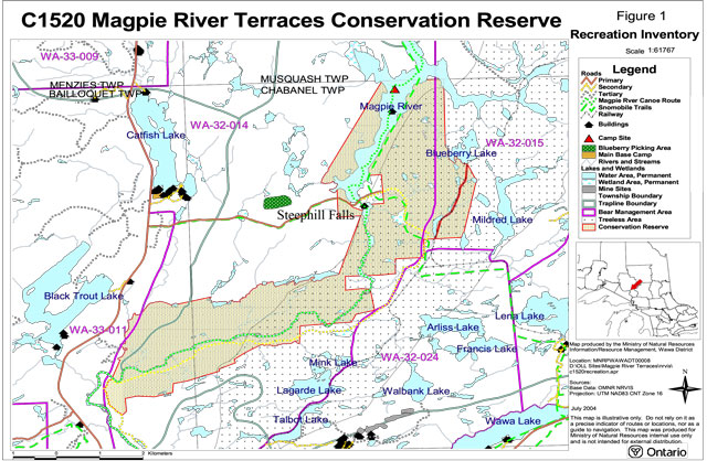
Map 1. Magpie River Terraces Conservation Reserve
Enlarge Figure 1 - Recreation inventory map of Magpie River Terraces Conservation Reserve
9.0 Appendix 1 - Test of compatibility
The Conservation Reserve policy provides broad direction with regard to the permitted uses. The policy provides only an indication of the variety of uses that will be considered acceptable in conservation reserves. The only caution is that “any new uses, and commercial activities associated with them, will be considered on a case by case basis, and, they must pass a test of compatibility to be acceptable.”
What does a ‘test of compatibility’ mean?
An examination of this must start from the premise of why an area is set aside – specifically, its representative natural heritage values. Criteria are then identified to guide compatibility considerations. These criteria apply to the long-term acceptability of both existing uses and new uses.
- Conformity to SCI/RMP: SCI describe values for which an area has been set aside and the range of appropriate uses that will be permitted in the area. SCI may also speak to the acceptability of other ‘new’ uses currently not occurring in the area.
The first ‘test’ is: “do proposed new land uses and/or commercial activities conform to the direction of the SCI/RMP for the conservation reserve? Would the new use(s) depart from the spirit of appropriate indicator land uses in the SCI/RMP?”
- Impact Assessment: If the proposed use(s) pass test 1 it is important to determine their impact on the area before they are approved. This should include the following:
- Impact on natural heritage values: “will the new use(s) impact historical or archaeological values in the area?”
- Impact on research activities: “will the new use(s) affect research activities in the area?”
- Impact on current uses: “will the new use(s) have any negative impact on the array of current uses?”
- Impact on area administration: “will the new use(s) increase administrative costs and/or complexity?” (For example, the cost of area monitoring, security and enforcement.)
- Impact on accommodating the use outside the conservation reserve: “could the use(s) be accommodated as well or better outside the conservation reserve?”
- Impact on socio-economics of the area: “will the new use(s) affect the community(ies) surrounding the area in a positive or negative way?” (For example, will the new use make an area less remote thereby affecting a local tourism industry that is dependent on the area’s remoteness for its appeal?)
- Impact on area accessibility: “does the new use(s) give someone exclusive rights to the area or a portion of the area to the exclusion of other existing uses?”