Minnitaki Kames Provincial Park Management Statement
This document provides policy direction for the protection, development and management of Minnitaki Kames Provincial Park and its resources.
Introduction
The purpose of this Interim Management Statement is to identify:
- park values which are to be protected;
- resource management prescriptions necessary to protect these values; and
- restrictions on use of natural resources within the park.
This Interim Management Statement is not intended to replace a Park Management Plan. Rather it is intended to guide the use of natural resources and related activities within the park until such a time as a Park Management Plan is prepared.
Background information
Name: Minnitaki Kames
Proposed class: Nature Reserve
MNR district: Sioux Lookout
MNR region: Northwestern
Total area(ha): 4, 422
Land:
Water:
Site region: 43-Lake Wabigoon
Site district: 4S-3
Date in regulation:
Regional setting map for Minnitaki Kames Provincial Park
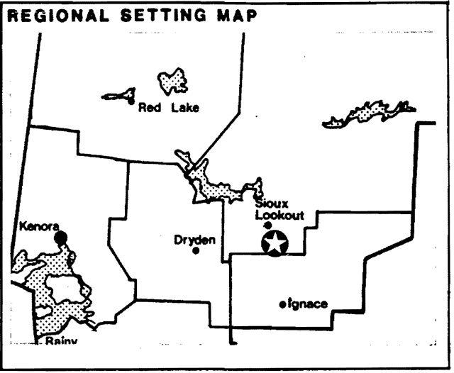
Enlarge this map for Minnitaki Kames Provincial Park
Targets
1. Life science representation
Site type/Landscape: L.U. 27 - Minnitaki Drift Complex
Species/Communities: Southern Boreal Forest Region and associated vegetative patterns.
2. Earth science representation
Geological. Theme: Wisconsinin/Timiskaming Interstadial
Feature: Lac Seul Moraine
- modified kame deposit
- wave cut terraces
- Lake Aaassiz strandlines
3. Cultural resource representation
Theme: N/A
Theme segment: N/A
4. Recreation opportunities
Day Use: N/A
Car Camping: N/A
Wilderness/Back country: N/A
Inventories
| Earth Science | Life Science | Cultural | Recreational | Other | |
|---|---|---|---|---|---|
| Reconnaissance Completion Date | Nov 1979 | Dec 1979 | |||
| Detailed Completion Date | |||||
| Required? | Yes | Yes |
Management guidelines
I. Land tenure
There are presently no alienated forms of land tenure within the park area and none will be considered pending the completion of the park management plan.
II. Land acquisition/disposition
There is presently no patented land within the park area and no disposition will occur pending the completion of the park management plan.
III. Existing/proposed development
There is no existing development within the park and none will be considered pending the completion of the park management plan.
IV. Recreation/activities
Sport hunting, fishing and a limited amount of camping occur along the shoreline of Minnitaki Lake within the vicinity of the park.
Guideline
Sport hunting will not be permitted within the Minnitaki Kames Provincial Nature Reserve. Enforcement will be accomplished through communication within park literature and signage along the shoreline of the park.
Camping along the shoreline of Minnitaki Lake within the park area will be permitted to continue for Ontario residents. Non-residents of Canada are subject to the conditions of the Crown Land Camping Program which presently prohibits Crown land camping within 500 metres of Minnitaki Lake. The Minnitaki Lake Provincial Nature Reserve is considered to be a non-operating park and normal park fees will not apply.
V. Commercial activities
Portions of two traplines (TR98-18, TR980-20) and one trappers’ cabin are presently located within the park.
The park lies within the Great Lakes Forest Products Ltd. English River Forest Management Agreement area.
Guideline
Trapping will be permitted to continue as a non-conforming use and will be phased out over time. The phase out will occur over a 21 year period (effective January 1, 1989) or when the trapper retires or dies, whichever comes sooner. In the event of a request for a transfer of either of the above two licences, the area contained within the park will be excluded from the reissued licence. The trapline cabin will be removed or dismantled when no longer required and the site rehabilitated to its natural condition.
Timber harvesting is not permitted in the park area. The park has been excluded from the English River FMA. This situation will be reflected in all management and operating plans that cover the park area.
No other commercial activities will be permitted pending the completion of the park management plan.
VI. Natural resources
A number of earth and life science values have been documented for the park area and detailed in the attached check sheets. Interim management efforts will be directed towards the protection of these resource values.
Due to the proximity of the park to forest harvesting areas and the susceptibility of the park values to fire, all fires within the park will be subject to initial attack and fire suppression efforts. Fire suppression techniques used will have as minimal effect as possible on the park environment. Such means of suppression as bulldozing, helipad locations, firecamps, and waterbombing with chemical additives will not be permitted except in critical conditions.
VII. Research
A more complete and detailed life science inventory will be necessary prior to the preparation of the park management plan.
Research activities that will enhance our scientific and resource knowledge of the park will be encouraged.
VIII. Native interests
The park lies within the Treaty #3 area. Status Indians enjoying treaty rights to carry on traditional natural resources harvesting activities will be permitted to carry on those activities in accordance with the terms of their treaty within the Minnitaki Kames Provincial Nature Reserve. Accordingly such Status Indians will be permitted to carry on those activities in certain circumstances. The details of those circumstances will be the subject of further discussion and review.
IX. Cultural resources
There are no known cultural resources within the park area.
Sources/references
Gray, Stephen L. 1980. Life Science Systems Planning Report West Patricia Land Use Plan
Harvey, E.T. 1980. Earth Science Systems Planning in the West Patricia Planning Area, Final Report.
Harvey, T., S. L. Gray, B. Thacker 1980. Landscape Units of the West Patricia Land Use Planning Area.
Ontario Ministry of Natural Resources, Backgrounder – District Land Use Guidelines, June 1983
Table IV: Recommended nature reserve candidates
Source: Backgrounder
District Land Use Guidelines
OMNR, 1983
| Name | MNR Region | Size (ha) | Mineral Exploration/Development1 | Hunting1 | Trapping1 | Commercial Tourism1 | Commercial Fishing1 | Bait Fishing1 | Other1 |
|---|---|---|---|---|---|---|---|---|---|
| 1. Trout Lake* | NW | 7,850 | Phase out | ||||||
| 2. Windigo Point* | NW | 380 | Phase out | ||||||
| 3. Lola Lake | NW | 6,350 | Yes | Yes | Yes | Yes | |||
| 4.Butler Lake | NW | 3,290 | Yes | Yes | Yes | ||||
| 5. Bonheur | NW | 720 | |||||||
| 6. Minitaki Kames* | NW | 4,340 | Phase out | ||||||
| 7. Sable Island | NW | 1,800 | Yes | Yes | Yes | ||||
| 8. Gameland | NW | 2,200 | Yes | Yes | Yes | Yes | |||
| 9. Nelles Township | NW | 800 | Yes | Yes | Yes | ||||
| 10. Blue Township | NW | 1,600 | Yes | Yes | yes | Yes | |||
| 11. West Bay | NC | 1,140 | Yes | ||||||
| 12. Windigo Bay | NC | 8,300 | Yes | Yes | |||||
| 13. Sedgeman Lake | NC | 5,800 | Yes | Yes | Wild Rice | ||||
| 14. Edward Island | NC | 530 | Yes | ||||||
| 15. Kiashk/Gull River | NC | 230 | |||||||
| 16. White Fish Lake (W) | NC | 1,150 | |||||||
| 17. White Fish lake (E) | NC | 190 | Yes | ||||||
| 18. Thomspon Island | NC | 170 | Yes | ||||||
| 19. Craig’s Pit | NC | 480 | Yes | Yes | Yes | Yes | |||
| 20. Matawin River | NC | 2,650 | Yes | Yes | |||||
| 21. Patagruel Creek | NC | 2,200 | Yes | ||||||
| 22. Kab River | NC | 1,970 | Yes | Yes | |||||
| 23. Fraleigh Lake | NC | 870 | Yes | Yes | |||||
| 24. Devon Road Mesa | NC | 90 | |||||||
| 25. Pigeon River Clay Plain | NC | 2,870 | Yes | Yes | |||||
| 26. Prarie River Mouth | NC | 290 | Yes | Yes | Yes | Yes | |||
| 27. Gravel River | NC | 790 | Yes | Yes | Yes | Yes | |||
| 28. Arrowhead Peninsula | NC | 490 | |||||||
| 29. Pie Island Mesa | NC | 50 |
1Uses recommended to continue prior to and after regulation
Map of Minnitaki Kames Provincial Park
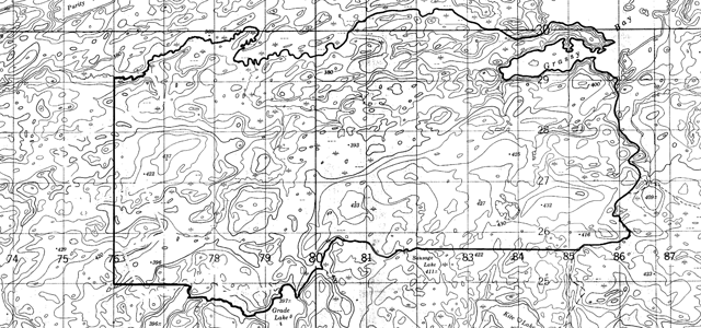
Enlarge this map Minnitaki Kames Provincial Park
Ontario nature reserves program life science inventory check-sheet
Name: Minnitaki Lake - Kames - Pine Stands
Map name: Yonde
Map number: 52G/13
UTM reference: 830270
County, district or regional municipality: District of Kenora
Latitude: 49° 54'N
Longitude: 91° 50'W
Altitude Minimum: 358 m
Altitude Maximum: 437 m
Map showing area boundaries of Minnitaki Kames Provincial Park
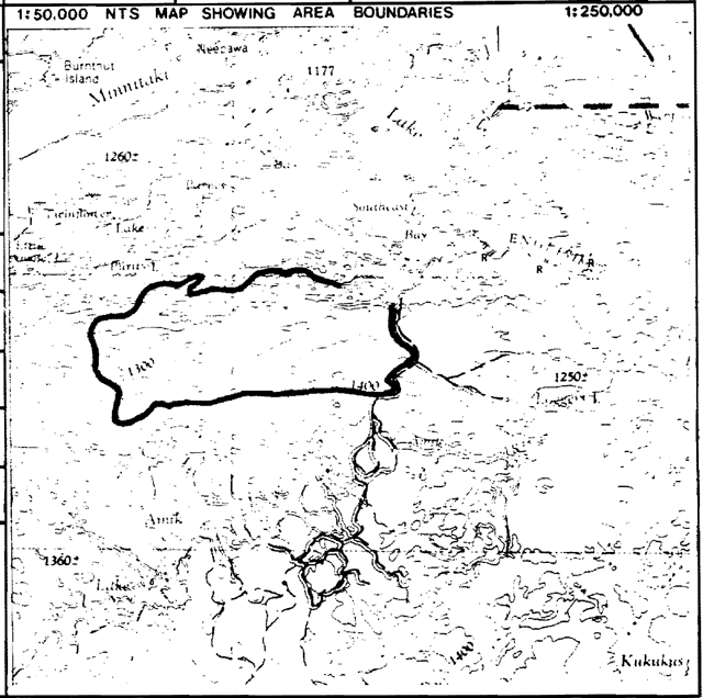
Enlarge this map of area boundaries of Minnitaki Kames Provincial Park
Locality: Sioux Lookout
Township lots concessions
Area: 11,500 acres 4,608 ha
Ownership: Crown
Administration: Ministry of Natural Resources
Forest region and district: B.11-U English R
Site region and district: 4S-3 (Sunstrum)
MNR Region and district: NW-Sioux Lookout
Conservation Authority:
Aerial photographs:
Base map: 498914
Year Roll flight line numbers: A 13561, 90-92
Physical and biological features:
Located south of Minnitaki Lake is a group of five large kame features (Zoltai, 1965). They occur here as the dominant landform feature on a moderately broken plain of shallow bedrock controlled drift with intervening lacustrine clay deposits in low areas. These features represent the largest kame deposits in northwestern Ontario and have added significance for the numerous raised shoreline features located on their slopes. These features are related to glacial Lake Agassiz. For a more detailed description of the morphology of these kames, see the earth science check sheet (same UTM number) by P. Kor.
These kames have both biophysiographic and plant community significance in that they stand out as distinct units above the surrounding landscape. This distinction is accented by the fact that each of the kames is completely covered by an extensive jack pine dominated closed coniferous forest. These features exhibit excellent integrity and have scientific, educational and interpretive value regarding landform vegetation relationships. All five of these kames are not necessary for representation. Two kames located at UTM 820270 and 775275 are of major earth science significance and their resultant protection would ensure adequate life science representation. The area between these two kames and immediately surrounding them may have potential for representing moderately broken sandy till terrain with lacustrine clay in the low lying areas. The river environment used as the northern boundary may support a wild rice marsh community.
Major information sources: Zoltai, 1965.
Evaluation and priorties: This area has excellent potential for representing landform-vegetation features which are not widespread in this site region.
Date compiled: December 3, 1979
Compiler: T. Noble.
Temperature table:
| Temperature regime | Substrate | Arid | Very Dry | Dry | Dry Mesic | Mesic | Wet Mesic | Wet | Very Wet | Saturated | Open Water |
|---|---|---|---|---|---|---|---|---|---|---|---|
| Colder | Rock | ||||||||||
| Colder | Sand | ||||||||||
| Colder | Loam | ||||||||||
| Colder | Clay | ||||||||||
| Colder | Organic | ||||||||||
| Normal | Rock | ||||||||||
| Normal | Sand | A | A | A | |||||||
| Normal | Loam | C | |||||||||
| Normal | Clay | B | B | ||||||||
| Normal | Organic | ||||||||||
| Warmer | Rock | ||||||||||
| Warmer | Sand | A | A | ||||||||
| Warmer | Loam | ||||||||||
| Warmer | Clay | D | |||||||||
| Warmer | Organic |
Earth science inventory checklist
Name: Minnitaki Lake Kames
Map name: Yonde
Map number: 52G/13
UTM Reference: 830270
County
Lat: 49°54'N
Long: 91°50'W
Alt min: 358 m
Alt Max: 437 m
A map of Minnitaki Kames Provincial Park
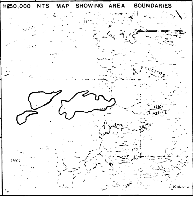
Enlarge this map of Minnitaki Kames Provincial Park
County:
Township:
Lot concession: About 22 km south of Sioux Lookout, south and west of Southeast Bay, Minnitaki Lake, inaccessible by road.
Area:
Ownership:
Administration:
MNR region & district: NWR-Sioux Lookout
Conservation auth:
Aerial photographs- basemaps
Year flight line numbers
Federal series A 13561, 90-92.
Earth science features:
- three major east-west trending kames which form the dominant features in an otherwise gently rolling bedrock-controlled upland. The kames may actually represent interlobate or ice-recessional features. They were deposited during the Timiskaming Interstadial about 9500-10,000 B.P.
Sensitivity:
- sensitive to denudation of vegetation cover, which may initiate destructive erosion
Significance:
- major raised shoreline features related to glacial Lake Agassiz
- largest kame deposits in northwestern Ontario by preliminary survey
Major references:
Zoltai, S.C., 1965
Hurst, M.E., 1933
Date compiled: November, 29 1979
Compiler: P. Kor
Physical features:
The features described in this checksheet were initially reported by Zoltai (1965, p.2 6). Air photo reconnaissance and two fixed-wing aircraft flights over the features constituted all the work attempted by the field crew. Landings were not possible, and the area is no longer accessible by road. Despite the size and significance of these landmarks, they have not been well documented in the literature.
Zoltai (1965, p.256) describes a remarkable group of five large kames south of Minnitaki Lake. The largest (centre UTM 830270, 52G/13) is over 12 sq. km in size, rising up to 30 m above the surrounding terrain. The somewhat elongated hills are oriented roughly east-west to southwest-northeast, forming distinct landforms in otherwise gently-rolling to abrupt granitic terrain (Hurst, 1933, Map 41j). The irregular hills are distinctly wave-washed, often with a flat topped character. All the kames have at least four well-developed wave-cut terraces, while the largest kame is reported to have an additional three strand lines (Zoltai, 1965, p.256). These strandlines are particularly well-developed on the smaller kame due north of Razor Lake (UTM 775275, 52G/13), where the higher strandlines completely circle the kame knoll. The material of which the kames are made was not observed and has not been documented, but probably consists of sand and gravel, unsorted to water-stratified (Embleton and King, 1975, p.485). The shorelines were formed in glacial Lake Agassiz.
Kames may be formed in many different ways, but most are associated with heavily laden meltwater streams which flow into small ponds on or within a stagnant ice mass. This forms an isolated mound when the surrounding ice melts away (Embleton and King, 1975, p.487). Kames generally occur in those areas where the ice sheets stagnated, melting away slowly and in such a way that much fairly coarse material was available. Much meltwater must also have been present to redistribute the debris and deposit it in and around the margins of the static and decaying ice masses (Embleton and King, 1975, p.490}. They may be associated with esker ridges where they are formed in poorly-aligned rows of isolated mounds.
The kames described in this checksheet bear a striking morphological resemblance to recessional or interlobate moraines observed elsewhere in northern Ontario. In the complex events of deglaciation which occurred during the Timiskaming Interstadial, it is conceivable that interlobate material was deposited perpendicular to the ice front in the stagnating ice sheet south of Minnitaki Lake. These observations require a great deal of research, but they are presented here for future consideration.
Significance:
The kames south of Minnitaki Lake are doubly significant from an earth science point of view. They represent the largest such features observed to date in northern Ontario. The kames also represent strandline development related to glacial Lake Agassiz in Ontario. The kame south of Grassy Bay (centre at UTM 820270} is the largest kame of the group, measuring roughly 6 km long and 2 km wide, and contains at least 7 levels of raised strandlines. The wave-cut terraces are best-developed on the smaller kame to the West (UTM 775275), where the upper levels completely circle the knoll. The features contribute to the representation of feaures related to the major deglaciation of the Timiskaming Interstadial.
Recommendations:
It is strongly recommended that at least the two kames mentioned above (at UTM's 820270 and 775275) be incorporated within a protective zone of the parks system. Economic pressures seem to be low, with only logging appearing to be the major threat in the near future. For the purposes of scientific evaluation and in order to retain interpretive and educational values, it is necessary to retain the integrity of the kames.
References:
Embleton, C. and King, C.A.M., 1975. Glacial Geomorphology. Edward Arnold (Publishers)Ltd., Great Britain.
Hurst, M.E., 1933. Geology of the Sioux Lookout Area. Ont. Dept. Mines, Vol. XLI, Pt.VI, 1932, p.1-33.
Zoltai, S.C., 1965. Glacial Features of the Quetico-Nipigon Area, Ontario. Can. J. Earth Sci., V.2, p.247-269.