Mono Cliffs Provincial Park Management Plan
This document provides policy direction for the protection, development and management of Mono Cliffs Provincial Park and its resources.
Park Management Plan
Note: This document has been scanned and formatted, and therefore is slightly different from the original version. March 2002
© 1998, Queen’s Printer for Ontario
Additional copies of this publication are obtainable from:
Earl Rowe Provincial Park
P.O. Box 872
Alliston, Ontario
L9R 1W1
Telephone: 705-435-4331
4747-3
(0.6k P.R., 98 04 17)
ISBN 0-7778-5487-2
Approval statement
I am pleased to approve the Mono Cliffs Provincial Park Management Plan, as the official policy for the management and development of this park. The plan reflects this Ministry’s intent to protect the natural features of Mono Cliffs Provincial Park and maintain high quality opportunities for outdoor recreation and heritage appreciation for both residents of Ontario and visitors to the Province.
The park management plan will be reviewed periodically throughout its 20 year life span to address arising issues or changing conditions.
This park management plan is deemed to be in conformity with the general intent and purpose of the Niagara Escarpment Plan pursuant to Section 13(1) of the Niagara Escarpment Planning and Development Act.
Signed by:
Norm Richards
Managing Director
Ontario Parks
Date: April 3, 1998
The Ministry of Natural Resources' Statement of Environmental Values (SEV) under the Environmental Bill of Rights (EBR) is a document which describes how the purposes of the EBR are to be considered whenever decisions that might significantly affect the environment are made in the Ministry. In the development of this management plan for Mono Cliffs Provincial Park, the Ministry’s SEV has been considered. The plan is intended to reflect the direction set out in the SEV, and to further the objectives of managing Ontario’s resources on an environmentally sustainable basis.
1.0 Introduction
The Niagara Escarpment straddles the centre of the rolling landscape of glacial moraines and spillways that makes up Mono Cliffs Provincial Park. To the north and south of the park the Escarpment lies buried beneath tonnes of glacial deposits. But at Mono Cliffs the Escarpment makes its most dramatic appearance in Dufferin County, looming 30 metres above visitors' heads. Tucked into the recesses of the Escarpment lies one of the largest concentrations of fern species in Ontario. Some, such as the Hart’s tongue fern, occur only in scattered locations in North America.
Above and below the Niagara Escarpment the park’s glacial legacy dominates. Once caught between three lobes of the ancient glaciers, glacial landforms now remain as testimony to the long-melted giants. The undulating "kame and kettle" topography of the Orangeville Moraine lies above the rock face. The Violet Hills meltwater channel, that carried south the water, ice and debris jettisoned from the glaciers' edge, has flattened the lands below the Escarpment. A patchwork of field and forest blankets these lands both above and below the Escarpment. The wetlands, springs and seepage areas of the park form some of the headwaters of the Sheldon Creek, a tributary of the Nottawasaga River which drains into Georgian Bay.
Mono Cliffs Provincial Park lies within the Township of Mono in Dufferin County, 15 kilometres northeast of Orangeville, and immediately north of the hamlet of Mono Centre (see Figure 1). This scenic countryside of dramatic cliffs, rolling hills and forests offers both local residents and tourists recreational opportunities including hiking, cross-country skiing, nature appreciation, horseback riding, bicycling and fishing.
As part of the efforts to protect the natural features of the Niagara Escarpment and provide public recreation associated with it, the provincial government began acquiring land in the Mono Cliffs area in the early 1970's for a provincial park. A Mono Cliffs Provincial Park Master Plan was prepared in 1974. Acquired provincial lands were first regulated under the Provincial Parks Act in 1985 (Ontario Regulation 45/85). The park boundary was amended to its present area of 732 hectares in 1994 (Ontario Regulation 179/94).
Ontario’s Niagara Escarpment was named as a World Biosphere Reserve by the United Nations Educational, Scientific and Cultural Organization (UNESCO) in 1990. The designation recognizes the natural features and ecological importance of the Escarpment, of which Mono Cliffs Provincial Park is an integral element.
Mono Cliffs is part of the Niagara Escarpment Parks and Open Space System (NEPOSS) which protects the significant natural and cultural features along the Escarpment, and provides for recreation and appreciation of the features. The NEPOSS presently consists of over 115 parks and open spaces owned and managed by a variety of agencies. The Bruce Trail is an essential component of the NEPOSS linking parks, open space areas and natural features.
Furthermore, Mono Cliffs is among a select handful of parks designated in the Niagara Escarpment Plan as nodal parks in the NEPOSS. Nodal parks are intended to serve as key staging areas, interpretative centres for each section of the Escarpment, and major starting places for exploring other nearby parks and open spaces. Within a 30 kilometre radius, this nodal park is flanked by Forks of the Credit Provincial Park, Ken Williams Resource Management Area, Glen Haffy Conservation Area, Mono Mills Lowlands, Humber Valley, Hockley Valley Provincial Nature Reserve, Boyne Valley Provincial Park, Mulmur Hills, Pine River Fishing Area, and Noisy River Provincial Nature Reserve.
Mono Cliffs lies near the confluence of the jurisdiction of four conservation authorities: Credit Valley, Nottawasaga Valley, Grand River and Metropolitan Toronto and Region. Each authority operates a number of conservation areas offering recreational opportunities.
In the absence of controlled access, park visitation can only be estimated. Approximately 30,000 day visitors use the park annually.
Extensive use of Mono Cliffs for outdoor education and recreation occurs through the Mono Cliffs Outdoor Education Centre, Sheldon Centre for Outdoor Education, and Boyne River Natural Science School.
Adjacent land uses presently include outdoor education, agriculture, rural and hamlet residential, reforestation, forest management, waste management and aggregate extraction.
2.0 Summary of significant issues
Numerous issues were raised during the park management plan review process. Following the release of the Mono Cliffs Provincial Park Preliminary Management Plan in 1996, public comment was sought on a range of issues regarding the park. Public comments on the preliminary document helped set the course for changes reflected in this park management plan.
2.1 Development and access
A single access point off the Mono Township 3rd Line, East of Hurontario Street (E.H.S.), will concentrate both parking and use below the Niagara Escarpment where the landscape is more tolerant of human activity. Associated development may include an entry control and fee station, washrooms, a modest picnic area, and visitor information displays. A new trailhead would be located adjacent to this area. These changes would contribute towards an enriched experience for park patrons and better protection of the park’s natural features.
All park development will be contingent upon the availability of funding. Partnerships and/or sponsorships will be encouraged where feasible and appropriate. Implementation plans and site plans will be prepared in advance of any development.
2.2 Appropriate activities
A variety of activities are permitted within Mono Cliffs Provincial Park. These include hiking, cross-country skiing, horseback riding and bicycling. It is recognized that these activities may have an impact on the park’s natural features and on other park users. Where necessary, appropriate controls will be implemented.
Rock scrambling or climbing and caving will not be permitted except under special circumstances, for example, special agreements or approved scientific research. Snowmobiling and motorized off-road vehicles will not be permitted in the park. Camping and associated facilities will be limited to an overnight rest area for Bruce Trail hikers only.
2.3 Trails
Mono Cliffs is a trail oriented park and thus improvements or changes to the trail system are a major issue. A complete rationalization of the park’s trail system was undertaken during the park management plan review process. The park’s trail system was assessed as to both need and environmental impacts. The future focus will be on a walking experience and the park will continue to serve as a link for the Bruce Trail.
Bicyclists and horseback riders will be confined to designated trails only. Mountain bikers will be encouraged to use alternative established trail centres outside the park.
All "unofficial" and environmentally non-sustainable trails will be closed. Where required, trails will be redesigned or relocated to minimize environmental impacts and user conflicts, or to channel use away from sensitive natural or cultural features. A single new multi-use trail will be developed to centrally connect the park’s trail system to the new trailhead adjacent to the 3rd Line, E.H.S.
Partners will be encouraged to participate in trail planning and management. A park trail implementation strategy may be prepared.
Figure 1: Regional Context
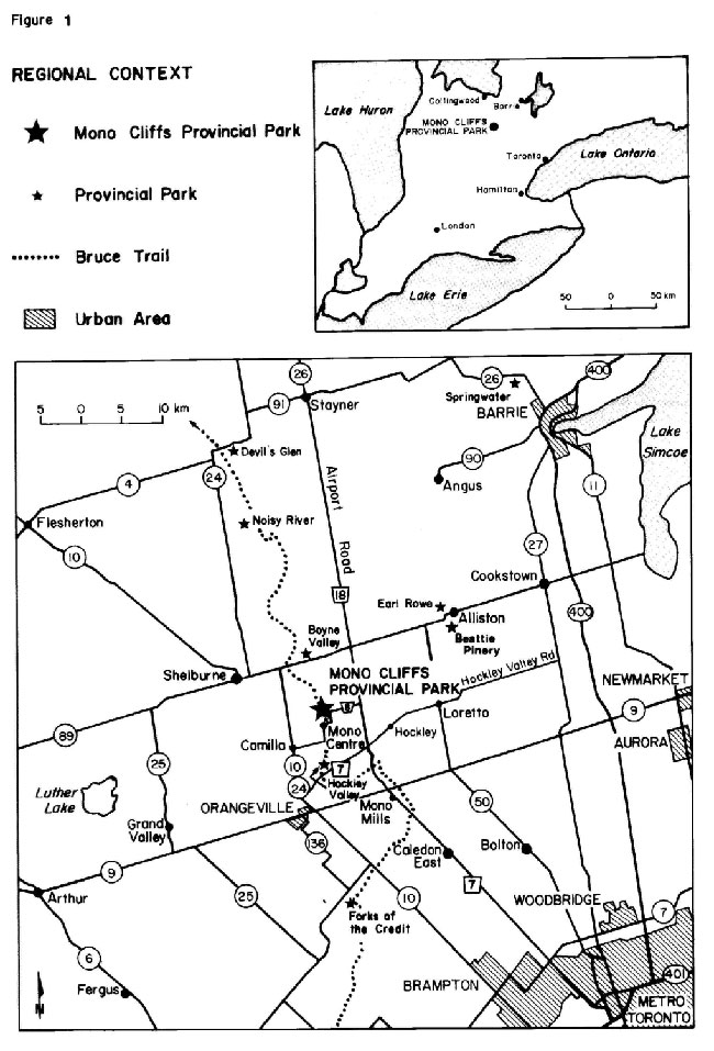
Enlarge Figure 1: Regional Context
3.0 Classification
Under both Ontario Parks' policy and the Niagara Escarpment Plan, Mono Cliffs Provincial Park is classified as a Natural Environment park because it incorporates outstanding recreational landscapes with representative natural features and historical resources to provide high quality recreational and educational experiences. The park also makes a significant contribution to all four provincial parks program objectives: protection, recreation, heritage appreciation and tourism.
Natural Environment parks protect significant resources in accessible locations, which substantial numbers of people are able to enjoy. These parks provide excellent opportunities for interpretation, outdoor activities and recreation.
4.0 Goal
The goal of Mono Cliffs Provincial Park is to protect the provincially significant geological and biological resources of the park and to provide opportunities for a wide variety of high quality recreational and educational experiences.
The Ontario Provincial Parks Planning and Management Policies govern all provincial parks, including Mono Cliffs. These policies were approved in 1978 and reaffirmed in 1988.
5.0 Objectives
This management plan for Mono Cliffs Provincial Park will incorporate the objectives of the Niagara Escarpment Parks and Open Space System as outlined in the Niagara Escarpment Plan.
There are four established objectives for the Ontario Provincial Parks System: protection, recreation, heritage appreciation and tourism. As a natural environment class park, Mono Cliffs contributes to each of these objectives.
5.1 Protection objective
To protect provincially significant natural environments incorporating natural, cultural, and recreational features.
The protection objective will be accomplished through appropriate park zoning, land use controls, research, monitoring and a greater park ecosystem approach to park planning and management. The greater park ecosystem can be defined as the area of influence surrounding Mono Cliffs from an ecological, social and economic point of view. It is also the area where most of the impacts affecting the park occur.
5.1.1 Life science
The life science features represented at Mono Cliffs Provincial Park are provincially significant. The site is highly diverse with 40 vegetation community types represented. Also of note is a 25 metre deep fissure cave complex, and bat hibernaculum, in which the skeletal remains of highly significant vertebrate species such as pika and marten, and 14 other mammal species have been discovered. The park sustains 472 species of vascular plants, including the nationally and provincially rare Hart’s-tongue Fern, Rugulose Grape Fern and American Ginseng. An exceptional total of 34 species of ferns and fern allies occur at Mono Cliffs. Eastern White Cedar old growth forest community has been identified.
Successional communities, in various stages of natural succession, are developing in old fields and along forest edges, creating excellent wildlife habitat. Fifty-three breeding bird species have been reported in the park, including the nationally and provincially rare Eastern Bluebird. Twenty-two species of mammals as well as 19 species of reptiles and amphibians have also been found.
This plan will ensure that recreational activities do not damage the park’s highly sensitive Escarpment bedrock and wetland communities and associated wildlife habitats.
5.1.2 Earth science
The earth science values of Mono Cliffs Provincial Park can be summarized as: the provincially significant representation of bedrock outliers; crevice caves; significant development of a gap in the pervasive sediment over the Niagara Escarpment through its central portion; representation of the Violet Hill meltwater channel and the Orangeville Moraine; the organic sediments at the bottom of McCarston’s Lake; and the combination of pristine forested uplands and formerly cultivated lowland areas which provide high scenic and aesthetic values to the park area, in addition to facilitating interpretation of the physical setting.
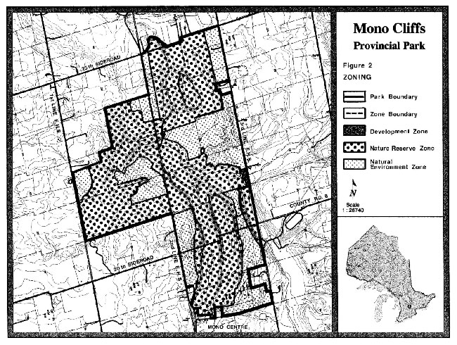
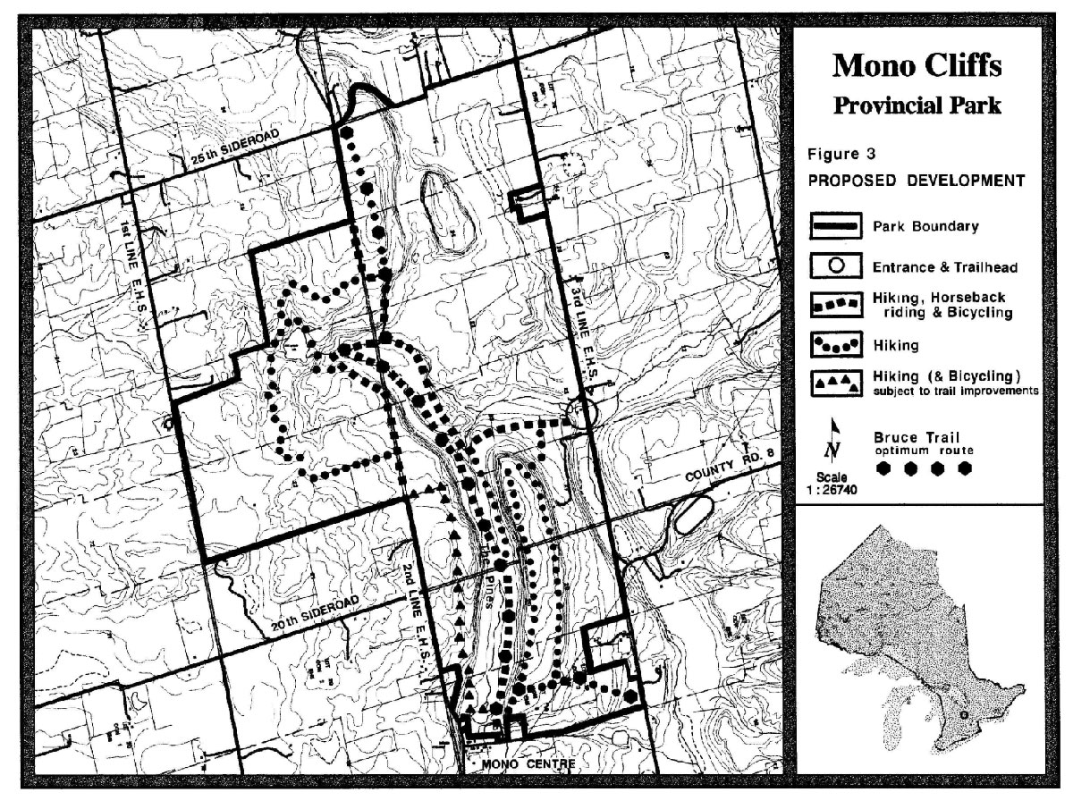
Projected levels of development and use do not pose a threat to the integrity of the geological features of the park. Future development of park facilities is intended to be located on the relatively level ground of the Violet Hill meltwater channel in the east-central portion of the park (see Figure 3).
5.2 Recreation objective
To provide primarily day-use opportunities in areas of outstanding recreational potential associated with natural environments.
Mono Cliffs will emphasise natural environment based experiences which provide individuals, families, and small groups with a low intensity of contact with fellow recreationists.
To a great extent the recreation objective will be accomplished through a complete rationalization and "as required" redesign of the Mono Cliffs trail system. This trail oriented park will support trails for hiking, bicycling, cross-country skiing and horseback riding. The Bruce Trail corridor is permanently established in the park in conjunction with public access and an overnight rest area.
Picnicking opportunities will be supported by the provision of an adequate number of picnic tables. The former target of 11,800 walk-in camping opportunities (50 campsites) called for in the 1983 Huronia District Land Use Guidelines (DLUG) has been eliminated in this plan. The DLUG will be amended to reflect this change.
5.3 Heritage appreciation objective
To provide opportunities for unstructured exploration and appreciation of the natural environment heritage of Ontario and to provide opportunities for exploration and appreciation of natural and cultural environments through interpretation and education based upon the character and significance of Mono Cliffs Provincial Park.
Individual and group exploration and appreciation will be encouraged in Mono Cliffs to the greatest extent compatible with, and complementary to protection of natural environments, earth and life science features, and cultural resources. Within context of available support and partnerships, the park may provide a range of interpretative and educational programmes which reflect the diversity of features and resources in the park and which are directed to a wide variety of user groups.
5.4 Tourism objective
To provide Ontario residents and out-of-province visitors with opportunities to discover and experience distinctive regions of the Province.
An estimated 30,000 day visitors use the park annually. Mono Cliffs will provide day use opportunities for passing as well as destination travelers, including those attracted from considerable distances. The benefit of attracting day use visitors to this site will be the contribution to the regional economy through park expenditures and tourist spending.
Mono Cliffs may partner with local interests to promote eco-tourism in the area. This nodal park will also disseminate information concerning park and open space activities, points of interest, and attractions in surrounding Niagara Escarpment areas and communities.
6.0 Boundary
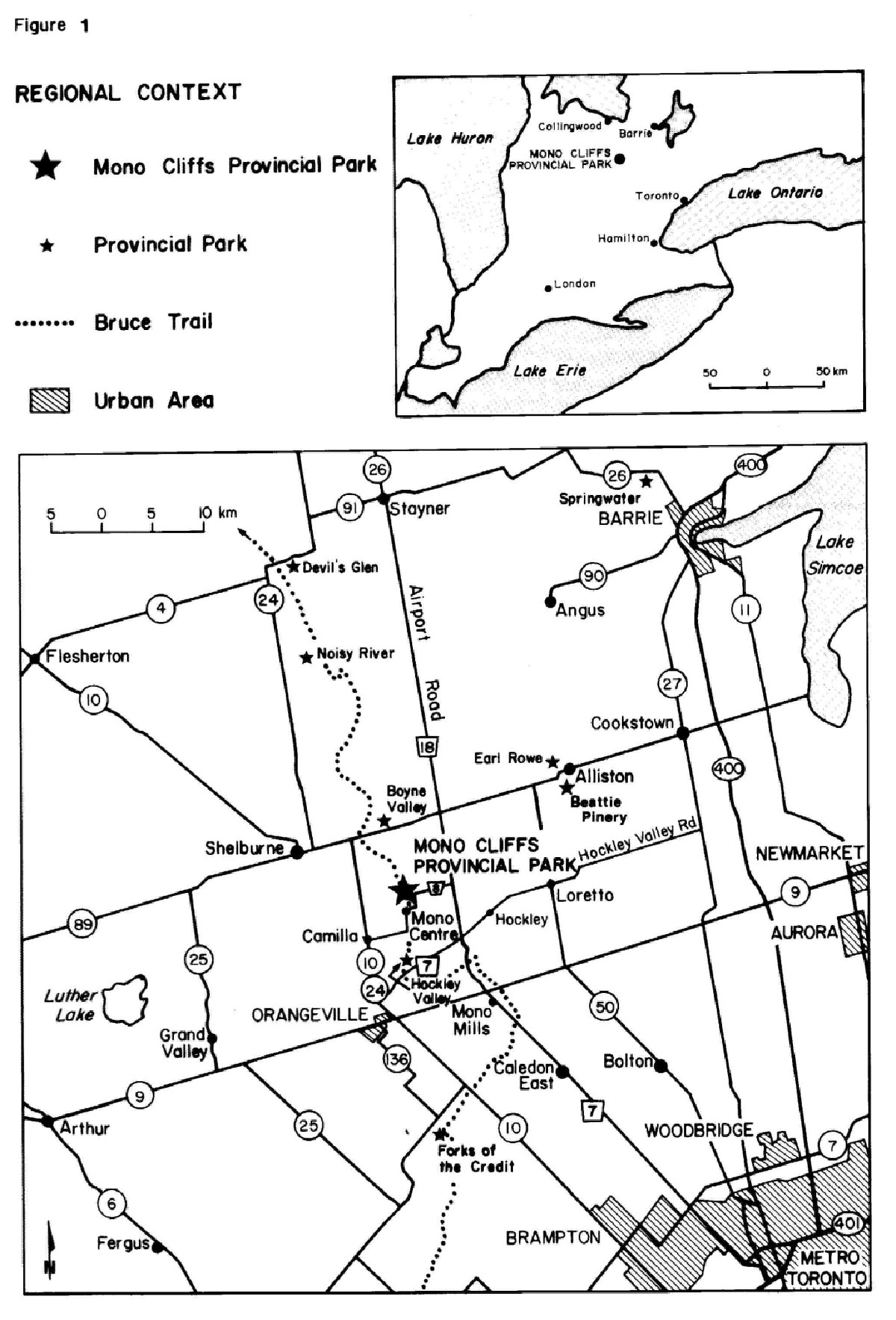
The park boundary is shown in Figures 2 and 3. Mono Cliffs is largely bounded by municipal roads and several private holdings. The park boundary is posted but may require additional signs, fencing and gating at some locations to control unauthorized vehicular or pedestrian access.
Land acquisition is substantially complete. Part of the 2nd Line, E.H.S., between the 25 Sideroad and the park may be acquired to facilitate the eventual closure of the 2nd Line parking area. If confirmed by a legal survey, a minor encroachment of the 25 Sideroad into the park may be deregulated and title transferred to the Township of Mono.
Ontario Hydro has an easement for a hydro transmission corridor crossing the southeast corner of the park (refer to Figure 2) and minor power line occupations south of the 25 Sideroad. No new utility rights-of-way or easements will be permitted in the park except as required to service park facilities.
Camp McGovern, a facility operated by the Big Brothers of Kitchener-Waterloo, is located on 40 hectares of park land, situated between the South Outlier and the 3rd Line, W.H.S., under authority of a land use permit. The camp was purchased by the province in 1973 with an agreement for 30 years of continued use, due to end in 2003. The organization may vacate the property prior to that date if it is successful in securing a new camp location.
7.0 Zoning
Lands contained within the park are zoned in accordance with their environmental qualities and required protection. The three zoning categories designated for Mono Cliffs Provincial Park (nature reserve, natural environment and development) are based on the Ontario Provincial Parks Planning and Management Policies. The zones differentiate the permissible degree of development, recreational uses and management practices (see Figure 2). These park zones are in basic conformity with Niagara Escarpment Parks and Open Space System zoning policies contained in the Niagara Escarpment Plan.
7.1 Nature Reserve zone
Mono Cliffs Provincial Park has 497 ± hectares zoned as nature reserve, representing nearly 70 percent of the park. These are the areas of greatest environmental sensitivity and thus warranting a much higher degree of protection. Natural features included within this zone are McCarston’s Lake, wetlands, deciduous forests and Niagara Escarpment features and associated habitats such as the North and South Outliers, Violet Hill meltwater channel, cliff edge and cliff face, and crevice caves.
7.1.1 General Nature Reserve zone policies
These zones will protect the significant natural features of the park for their intrinsic value and to sustain ecological diversity and for limited public use and appropriate research.
Permissible uses will include hiking, cross-country skiing, natural heritage appreciation, and opportunities for approved scientific research. Development will be restricted to trails, necessary signs, stairways and viewing platforms at the Carriage Trail and Jacob’s Ladder, limited interpretative facilities, and temporary facilities for research and management.
Bicycling and horseback riding will be permitted only on designated trails within limited portions of the nature reserve zone. Both uses will be considered existing non-conforming uses within this zone.
7.2 Natural Environment zone
The various natural environment zones constitute about 233 ± hectares, or about 30 percent of the park. These zones primarily include old field habitats, some upland forested areas, and scattered wetlands, streams, springs and seepage zones. Sensitive areas within the zones include the woodlands and regenerating old fields south of McCarston’s Lake and the wetlands and forested slopes west of the 3rd Line, E.H.S.
7.2.1 General Natural Environment zone policies
These zones will provide access and support for low intensity recreational activities. Development is limited to trails, necessary signs, interpretative and support facilities, and temporary facilities for research and management.
Uses within the natural environment zones will include hiking, horseback riding, sport fishing, cross-country skiing, bicycling, heritage appreciation and approved scientific research. Horseback riding and bicycling are limited to designated trails.
Removal of non-native plant species such as Scot’s Pine may occur in this zone. Natural forest succession will be encouraged in old fields and pastures.
Figure 2: Zoning
During its tenure in the park, Camp McGovern will be considered an existing, non-conforming use within the natural environment zone. Upon vacant possession of the property, the associated structures may be removed or used for compatible park uses. The site will be rehabilitated and restored as required.
Future consideration may be given to rezoning natural environment areas with advanced natural regeneration to nature reserve zoning.
7.3 Development zone
The two hectare development zone is situated adjacent to the 3rd Line. The zone occupies only one percent of the park in an area of old field situated on the relatively level ground of the Violet Hill meltwater channel in the east-central portion of the park, between the North and South Outliers.
7.3.1 General Development zone policies
This zone will provide access to the park and limited facilities to support a range of day use activities. Implementation planning and site planning will precede all park development.
An entry control and fee station and day use parking for around 100 vehicles will be provided, with capacity for horse trailers and school buses. A small number of picnic tables will be provided.
Existing farm buildings may be retrofitted to house displays and facilities for natural heritage education, research and park administration. Washroom facilities will also be incorporated. A park residence and garage adjacent to the new park entrance will be retained.
A roadside, landscaped earthen berm will be installed to serve as a visual buffer between the 3rd Line, E.H.S., and the parking area. Adjacent streams, ponds and wetlands will be adequately buffered from new development.
The three existing satellite parking areas will be closed simultaneously with the opening of the new entrance off the 3rd Line, E.H.S.
8.0 Resource management policies
8.1 Land and water management
No new utility easements or rights-of-way will be permitted except for those required to service the park. The existing easement for a hydro transmission corridor traversing the southeast corner of the park creates a marked visual impairment and also contributes to ecological fragmentation. Vegetation management prescriptions compatible with park objectives may be negotiated with Ontario Hydro.
Wetlands, seepage areas and streams, by their very nature, preclude major development. The organic soils underlying wetlands make facility development impractical. Seepage of ground-water occurs on may of the park’s slopes. Where it is not feasible to route trails around wetlands, boardwalks and bridging may be used.
McCarston’s Lake has been the subject of palaeoecological research (the study of ecology of past eras). Recreational use of both the lake and the artificial ponds will be limited to angling.
Streams are important ecological resources and are sensitive to siltation. Protection of the headwaters of streams like the Sheldon Creek is an important objective for park management. Necessary measures may be taken to maintain and enhance coldwater fish habitats (such as, development setbacks, bottom draw on artificial ponds and fringe plantings).
At some locations proper fencing around the perimeter of the park is required to prevent unauthorised access by vehicles. Closure of the three existing satellite parking areas will require suitable signing, gating and/or barrier placement.
Land use permits will not be issued for agricultural purposes.
8.2 Vegetation management
All of the recommendations below will be addressed in a vegetation implementation plan.
An agreement with Ontario Hydro may be sought to limit vegetation management in the hydro transmission corridor to non-mechanized removal of trees and shrubs. Use of herbicides will be discouraged. Planting of native tree species and shrubs in adjacent open areas may be undertaken to hasten the vegetation recovery, with a suitable setback for safety purposes.
Selective cutting of hazardous trees adjacent to trails or development areas may be undertaken. Commercial timber harvesting will not be permitted.
Rare and significant plant species occurring in the park will be protected to ensure their continued presence. The status of rare plants will be monitored. Specific protection, enhancement, recovery or reintroduction programs may be undertaken as necessary.
Alien or non-native plant species will not be intentionally introduced into the park. Where introduced species such as Scot’s Pine (plantations and self-seeded), Norway Maple and Purple Loosestrife are already established and threaten natural or cultural values, particularly in nature reserve zones, an eradication program may be undertaken.
Restoration of open fields and areas cleared of Scot’s Pine will normally be accomplished through the natural ecological process of vegetation succession. The practice of maintaining the open character of the landscape through mowing and pasturing has been discontinued. Prescribed burning will not be employed as a vegetation management tool.
The control of forest insects and diseases, alien species and noxious weeds may occur where there is a threat to the park’s natural features or adjoining private lands. The use of chemical herbicides or pesticides will be considered only when other means of control are not feasible.
8.3 Fisheries management
A variety of fish species frequent the various streams and branches of the Sheldon Creek. Brook trout can be found in the park’s creeks and ponds. Largemouth bass, yellow perch and brown bullhead also occur in McCarston’s Lake and may have been stocked. Other fish likely occur as field investigations have been limited.
Angling in the various ponds and in McCarston’s Lake will be encouraged within the limits of sustainable use of the fish community. Introduction of undesirable, non-native species will be avoided.
Measures may be taken to maintain and enhance coldwater stream habitats by converting artificial ponds to bottom-draw, ensuring development setbacks and planting appropriate tree and shrub species beside streams and ponds.
A fisheries resource implementation plan may be prepared for the park.
8.4 Wildlife management
Non-native or alien wildlife species will not be intentionally introduced. Where alien species are already established and threaten natural or cultural values, a program of control may be undertaken. Missing native species may be reintroduced were ecologically feasible and acceptable. The wild turkey has been reintroduced into the area and has been sighted in the park. A healthy park population could eventually serve as a source for restocking surrounding areas.
The status of rare species will be monitored to ensure their continued presence in the park. Specific protection or recovery programs may be undertaken as necessary.
Sport hunting and commercial trapping will not be permitted. However, control of particular species may be required for public safety, protection of property, and perpetuation of natural values.
A fissure cave containing a bat hibernaculum in one of the park’s nature reserve zones is closed to public access, with the exception of approved scientific research activities.
A wildlife resource implementation plan may be prepared for the park.
8.5 Cultural resources management
Many old roads and carriage trails form part of the park’s trail system and serve to illustrate how early settlers had to adapt to the landscape’s contours. The remains of stone walls and foundations of former homes, accessory buildings, barns and lime kilns are located throughout the park. These features are of primarily local historical interest, nevertheless, they help to illustrate the human relationship with the land and the evolution of the landscape following abandonment.
No specific preservation management of the cultural resources of the park will be undertaken. A cultural resource implementation plan will not be required, however, relevant research and interpretation will be encouraged.
8.6 Scenic resources management
A Landscape Evaluation Study completed in 1976 ranked the Mono Cliffs escarpment as "very attractive". The scenic views in the park are recognized and will be protected.
Mowing and grazing of former fields and pastures will not be used as a means of maintaining the views. Less intensive methods of vegetation management to preserve localized views may be employed, but for the most part the process of natural regeneration will occur unhindered. A process of rationalization and redesign of the trail system will place emphasis on access to scenic viewpoints and their protection. The existing viewing platform located along the Cliff Top Trail will be maintained for viewing purposes.
9.0 Operations policies
A Park Operations Plan will be prepared to provide park staff or partners with the necessary direction required to operate the park on a day-to-day basis. In addition to addressing the operations policies which follow, the plan will include such topics as budget, staffing, maintenance schedules, enforcement and emergency services. Wherever possible, the provisions of the plan will be consistent with the approved Ontario Provincial Parks Minimum Operating Standards, and will be reviewed annually and updated as required.
9.1 Natural heritage education
Services for park visitors, including school groups, will be primarily oriented towards self-use. The three components of the natural heritage education program are information, interpretation and outdoor recreation.
9.1.1 Information
Objectives for the information component of the natural heritage education program include:
- inform visitors about the park, its features, facilities and management
- promote recreation and interpretative opportunities in the local area, particularly in the context of the Niagara Escarpment Parks and Open Space System
- stimulate an understanding of the Niagara Escarpment and its many natural and cultural values (e.g. World Biosphere Reserve)
- orient visitors to where they are in relation to other parks, open space areas, trails, natural features and points of interest
- instil in visitors a sense of respect for the park environment
- describe the role of Ontario Parks and the Ministry of Natural Resources; and
- provide a means for the visitor to communicate with Ontario Parks regarding park management
The preceding objectives may be achieved through any combination of publications (specifically a park brochure and trail guide), signs, information display panels, media, informal meetings with users groups and personal contacts with park visitors. Literature promoting the Escarpment, the Niagara Escarpment Plan, and the Niagara Escarpment Parks and Open Space System will be made available at this nodal park once suitable facilities are in place.
9.1.2 Interpretation
Mono Cliffs Provincial Park contains a variety of significant and interesting natural features (earth science and life science) as well as confined historical themes worthy of interpretation.
Interpretation of the following will be essentially by self-use trails in conjunction with publications and on-site facilities such as, plaques, signs and display panels.
The old barn adjacent to the proposed new entrance and trailhead off the 3rd Line, E.H.S. may be used as a visitor centre. The centre would house displays and facilitate educational programs.
Earth science
Features include the provincially significant earth science representation of the outliers associated with the Niagara Escarpment, fissure caves, portions of the Orangeville Moraine and the Violet Hill meltwater channel, and the water-filled kettle known as McCarston’s Lake.
Life science
Features include a wide range of Escarpment habitats and distinctive vegetation communities supporting 26 significant plant species (three nationally and provincially rare), specialized niches rich in ferns and fern allies, old growth Eastern White Cedar forest community, and significant fauna (one nationally and provincially rare bird species).
Historical
The park has two basic historical themes associated with agricultural settlement and lime production.
A Mono Cliffs Provincial Park Teacher’s Guide was developed in 1991 by an advisory group composed of staff from the Ministry of Natural Resources and representatives from nearby outdoor education centres.
9.1.3 Recreation
Mono Cliffs provides opportunities for low-key, trail-oriented activities like hiking, horseback riding, cross-country skiing, fishing and bicycling. Park programs and publications will indicate the recreation opportunities available to park visitors.
9.2 Research
Scientific research and monitoring by authorized groups and individuals will be encouraged. Researchers must comply with Ontario Parks' policy on research activities in provincial parks and will require prior written permission.
Examples of projects undertaken to date include paleoecological research in McCarston’s Lake and a survey of Cryptoendolithic algae of the escarpment, and the extent of old growth cliff edge forest community.
Research priorities are:
- vegetation restoration techniques, specifically indigenous hardwood establishment and understorey development
- cliff ecology and the Eastern White Cedar old growth forest community
- impacts of trail use on natural values; and
- recreational activities and uses of the park, visitor profiles and marketing assessments
9.3 Recreation
Year round day use activities will be based on interaction with the natural environment and appreciation of the natural and cultural values of the park. Recreational activities will be low intensity in the nature reserve, natural environment and development zones.
Recreational activities such as hiking, fishing, cross-country skiing, bicycling, horseback riding, picnicking and nature appreciation will be allowed. Mountain bikers will be encouraged to use suitable facilities outside the park. Rock climbing and caving are not permitted (with the exception of approved scientific research and special agreements) as these activities present a major public safety concern and may have had a negative impact on the natural environment. Rock scrambling at Jacob’s Ladder has been negotiated with a limited number of school boards for supervised school group use only.
Snowmobiles and motorized off-road vehicles will not be allowed on park trails. Because of the sensitive nature of much of the landscape, and the heavy pedestrian use which is anticipated, bicycling and horseback riding will only be permitted on designated trails (see Figure 3).
The primary access for park visitors will be from the east through the proposed main park entrance off the 3rd Line, E.H.S. Remote trail access at authorized locations will be permitted, primarily to serve local residents, the North York Board of Education Outdoor Education Centre and Bruce Trail hikers.
A walk-in overnight rest area for small groups of Bruce Trail campers (one to six persons) is presently located at "The Pines". The overnight rest area may eventually be relocated to a northern park site near the 2nd Line, E.H.S. Washrooms, a fireplace and picnic tables may be provided in conjunction with the overnight rest area. A carry-in, carry-out garbage policy will be promoted.
9.4 Marketing
A park marketing strategy may be prepared focusing on eco-tourism, attracting visitors during low use periods and taking advantage of opportunities for cooperative marketing through partnerships. The marketing strategy will incorporate the role of Mono Cliffs as a nodal park within the Niagara Escarpment Parks and Open Space System and as an element of the Niagara Escarpment World Biosphere Reserve.
10.0 Development policies
Proposed development (see Figure 3) has been planned according to natural environment provincial park standards. All development will be carried out in accordance with approved implementation plans and site plans. Specific site designs will be responsive to environmental sensitivity, accessibility and landscape aesthetics.
10.1 Access
The intent is to develop a single public vehicle access and entry control and fee station off the 3rd Line, E.H.S. The entrance road will provide access to a picnic area, washrooms, trailhead and visitor centre in the development zone. Parking for approximately 100 vehicles will be provided, including spaces for buses and horse trailers.
As development proceeds, the existing satellite parking areas at the north and south limits of the 2nd Line, E.H.S., and at Mono Centre will be closed. These sites will be rehabilitated and serve as access points for park maintenance, emergencies services and trail use.
10.2 Day use area
A modest picnic area is planned in the development zone off the 3rd Line in conjunction with the proposed trailhead and visitor centre. Picnic tables and washrooms will be provided.
10.3 Trails
Mono Cliffs is a trail oriented park with the emphasis on walking and hiking opportunities. Trail proliferation and duplication along with the cumulative impacts of heavy trail usage on soils, plant communities and wildlife habitat are significant issues for park management. Details of trail closures, relocation, redesign, rehabilitation, renaming and so on, will be addressed in a park trail implementation strategy.
Park trails intended for pedestrian use only will be posted accordingly and may have stiles or other suitable barriers installed to prevent unauthorized access. Bicycling (including mountain biking) and horseback riding will be confined to designated trails only. No trails will be permitted in the vicinity of the North Outlier.
Future trail access and privileges will be conditional upon the cooperation of all trail user groups. Ontario Parks staff may exercise their authority to temporarily or permanently close specific routes to any or all types of trail uses.
Figure 3: Proposed Development
Enlarge Figure 3: Proposed Development
Closures may be required to facilitate trail rehabilitation, or in reaction to repeated user non-compliance (e.g., straying off marked trails, improper use of designated trails, etc.). The impacts of trail use will be monitored and used as a basis for management decisions. These policies are in keeping with the protection objective for Mono Cliffs Provincial Park.
Park staff will work in partnership with groups like the North York Outdoor Education Centre, the Dufferin Hi-land Bruce Trail Club and the Mono Hills Saddle Club to maintain, plan and manage park trails. Trail custodian agreements may be put in place.
10.3.1 Bruce trail
Approximately five kilometres of the Bruce Trail corridor lie within the park and are co-managed with the Dufferin Hi-land Bruce Trail Club. Three of the park’s trails, the Cliff Top Trail, South Outlier Trail, and McCarston’s Lake Trail, are designated as Bruce Trail side trails. At the north end of the park the optimum route for the Bruce Trail will parallel the 2nd Line, E.H.S., but will be sited well back from the Escarpment bluff in order to buffer and protect sensitive natural features. This new trail will replace the present route which travels along the 1st Line, E.H.S.
10.3.2 Cliff top trail
This three kilometre trail runs from Mono Centre to join the McCarston’s Lake Trail and Spillway Trail near Jacob’s Ladder. It is very wet in the vicinity of the ponds near Mono Centre and development of a boardwalk in this section will be necessary. Above the Escarpment, development of parallel trails has led to unnecessary duplication, soil compaction and loss of vegetation. The section north of the Carriage Trail will be closed and rehabilitated.
Subject to necessary trail improvements, bicycling may be reintroduced onto the section of the Cliff Top Trail from the 2nd Line, E.H.S., to the hamlet of Mono Centre.
10.3.3 South outlier trail
This walking trail snakes for four kilometres around the outlier at the south end of the park. Trail closure and rehabilitation has reduced trail proliferation at the southern ascent onto the outlier. The South Outlier Trail will be linked to the proposed multi-use access trail at the north end of the outlier.
10.3.4 Spillway trail
The Spillway Trail partly follows an old road bed along the Violet Hill meltwater channel. Informal side trails at the north end of the South Outlier lead up the cliff, causing destruction of vegetation. Trail closures and rehabilitation will occur at these locations.
10.3.5 McCarston’s Lake trail
The area associated with the McCarston’s Lake Trail is prone to problems with erosion and trail proliferation. Remedial work on a number of wet areas along this trail will continue. Surplus trails will be closed and rehabilitated. Trail improvements will be made to accommodate walking and hiking only.
10.3.6 Carriage trail
This short walking trail spans the cliffs and joins the Bruce Trail in the spillway below, between the main Escarpment and the South Outlier.
10.4 Interpretative facilities
A series of interpretative panels may be situated at points of access and other key trail locations throughout the park. Interpretative panels or displays may also be installed in, or adjacent to the barn at the new 3rd Line, E.H.S., entrance.
10.5 Research facilities
Existing park facilities may be used to support approved research activities both in Mono Cliffs Provincial Park and the adjacent portions of the Niagara Escarpment. No new permanent research facilities will be developed.
10.6 Operational/maintenance facilities
An existing barn off the 3rd Line, E.H.S., near the proposed entrance to the park will be used as a park operations and administration facility. An entry control and fee collection station will be installed in conjunction with the new park entrance. Once Camp McGovern has been vacated, on site facilities may be removed or used in support of park operations.
11.0 Implementation priorities
In the implementation of the park management plan, Ontario Parks will actively pursue opportunities for partnerships involving other agencies and groups. Park development and preparation of implementation plans will be contingent upon the availability of funding and unforeseeable changes in priorities or park policy. Implementation of the park management plan and operation of the park will meet the requirements of the Environmental Assessment Act.
Of high priority will be the development of a new park entrance, entry control and fee station, complete with parking, washrooms, interpretative panels and displays, picnic facilities and access to the trail system. Measures to improve the trail system will also be a top priority.
12.0 Summary of public consultation
Public consultation was a very important part of the park management planning process. The four phases of the 1974 Mono Cliffs Provincial Park Master Plan review consisted of:
- Phase 1 - Terms of Reference
- Phase 2 - Background Information, Issues and Options
- Phase 3 - Preliminary Management Plan
- Phase 4 - Approved Park Management Plan
Phase 1 consisted of the preparation of the Terms of Reference in 1990 for the management plan review. During the spring and summer of 1991 a survey was conducted on park use and visitors' perceptions of the park. Questionnaires were distributed at the park and also mailed to nearby landowners. A total of 72 responses were analyzed.
Phase 2 included the publication of the Mono Cliffs Provincial Park Background Information, Issues and Options in 1991. The report’s appendix presented a summary of the visitor questionnaire. A public open house was advertised and subsequently held in Mono Centre on November 27 and 28, 1991. A total of 199 submissions were received from individuals, groups, municipalities and government agencies. The comments and ideas were used in formulating the preliminary park management plan. The major issues raised during this stage of the public consultation process were:
- location of existing and proposed parking areas
- location of access points
- location and types of trails; and
- protection of natural features
Phase 3 also contained a significant public consultation component. This stage of the planning process coincided with the hosting of the International Countryside Stewardship Exchange 1996 by the Township of Mono. The preliminary management plan, complete with a summary of public comment on issues and options, was distributed for public review. Open houses were advertised and later conducted in Mono Centre on August 14 and 17, 1996, with a combined total attendance of 180 persons. In response to the preliminary plan 125 written submissions were received.
As part of Phase 4, all public comments were fully considered in the preparation of the recommended park management plan. Changes to the final document included:
- reduction of proposed parking spaces from 250 to 100
- relocation of the proposed entrance further south along the 3rd Line
- elimination of some proposed facilities (for example, a picnic shelter)
- refinement of trail policies
- greater emphasis on partnering and working with local interest groups and volunteers; and
- heightened focus on the protection objective
A plan review update was mailed out in September, 1997 to provide a "snapshot" of the final recommendations that would go forward for approval in the final management plan. The bulletin focused on the major management, development or operational issues raised during the plan review process. Two written responses were received as a result of this mailing.
The final park management plan was approved, published and distributed in the spring of 1998. All those persons who directly contributed to the planning process were mailed a copy of the approved document. A local news release was issued to announce the release of the management plan.
Policy proposal and decision notices were posted on the Environmental Bill of Rights electronic registry at the appropriate stages of the planning process.
Reference copies of the terms of reference, background information - issues and options report, preliminary management plan and approved management plan are available through Earl Rowe Provincial Park near Alliston.
13.0 References
Baran, Michael. Ecological Assessment of the Proposed Bruce Trail Optimum Route Within Mono Cliffs Provincial Park. Bruce Trail Association, Bruce Trail Project, Georgetown, 1996.
Bishop, F. Interpretative Directional Planning for Mono Cliffs Park Reserve. Ontario Ministry of Natural Resources, Midhurst, 1973.
Bruce Trail Association. Bruce Trail Comprehensive Plan. Burlington, 1991.
Bruce Trail Association. Bruce Trail Reference. 19th ed. Hamilton, 1994.
Carruthers, P. An Archaeological Transect Through Ontario. Heritage Planning Recommendations for the Niagara Escarpment Development Area. Ministry of Culture and Recreation, Historical Planning and Research, Toronto, 1976.
Conservation Authorities Branch. Nottawasaga Valley Conservation Report. Department of Energy and Resources Management, Toronto, 1964.
Cowell, D.W., and Woerns, N.M. Earth Science Candidate Nature Reserves in the Niagara Escarpment Planning Area. Ontario Ministry of Natural Resources, Parks Planning Branch, Toronto, 1975.
Cuddy, D. Ecological Assessment of Mono Cliffs Provincial Park, Dufferin County, Ontario. Ontario Ministry of Natural Resources, Central Region, Richmond Hill, 1973.
Cuddy, D.; Lindsay, K.; and Macdonald, I. Significant Natural Areas Along the Niagara Escarpment. Ontario Ministry of Natural Resources, Toronto, 1976.
Dearden, P., and Sadler, B. "Landscape Evaluation: Approaches and Applications", Western Geographical Series. Volume 25, 1989, University of Victoria, Victoria, B.C.
Edwards, K. A Geographical Study of Mono Township. McMaster University, Hamilton, 1964.
Frost, N. Mono Cliffs Provincial Park Teacher’s Guide. Boyne River Natural Science School, Shelburne, 1991.
Greenland, G. Brief History of the Mono Rocks Park Reserve Area, Mono Township, Dufferin County, Ontario. Ontario Ministry of Natural Resources, Toronto, 1973.
Gwyn, Q.H.J. Quaternary Geology of the Dundalk Area, Southern Ontario. Open file Report 5132. Ontario Division of Mines, Geological Branch, Toronto, 1975.
Hamalainen, P., and Pelshea, V. The Niagara Escarpment Archaeological Survey, Progress Report Number 2: Mono Rocks and Earl Rowe Provincial Parks. Ontario Ministry of Natural Resources, Parks Planning Branch, Toronto, 1973.
Harris, R.; De Freitas, C.; and Roulston, P. "The Settlement of Mono Township", Canadian Geographer. Volume 19, 1975, pp. 1-17.
Hoffman, D.; Mathews, B.; and Wicklund, R. Soil Survey of Dufferin County, Ontario. Ontario Agricultural College and Agriculture Canada, Guelph, 1964.
Jalava, J.V.; Varga, S.; and Riley, J.L. Ecological Survey of the Niagara Escarpment Biosphere Reserve (draft). Ontario Heritage Foundation and Ontario Ministry of Natural Resources, 1995.
Kor, P. An Earth Science Inventory and Evaluation of Mono Cliffs Provincial Park. Ontario Ministry of Natural Resources, Aurora, 1991.
Kovacevic, D. Historical Architecture Study, Proposed Provincial Park at Mono Centre. Ontario Ministry of Natural Resources, Midhurst, 1973.
Larson, D.; Matthes-Sears, U.; and Spring, S. "Organisation of the Niagara Escarpment Cliff Community", Canadian Journal of Botany. 67, 1989, pp. 2731-2742.
Larson, D.W. The Extent of Ancient Cliff-Edge Forests of the Niagara Escarpment. Department of Botany, University of Guelph, Guelph, 1989.
Leitch, A. Into the High Country: The Story of Dufferin the Last 12,000 Years to 1974. County of Dufferin, 1975.
Lindsay, K. A Biological Inventory and Evaluation of Mono Cliffs Provincial Park. Ontario Ministry of Natural Resources, Aurora, 1991.
Lindsay, K. A Study of the Flora of the Mono Rocks Area, Dufferin County, Ontario. Undergraduate Thesis, University of Toronto, Toronto, 1973.
Lindsay, K. Trails Plan for Mono Cliffs Provincial Park. Ontario Ministry of Natural Resources, Midhurst, 1988.
Marshall, J. Half Century of Farming in Dufferin.
Marshall, J., and Anderson, J. The Green Hills of Mono. Township of Mono, 1974.
Mono Township. Future Growth Scenarios, Township of Mono. 1991.
Mono Township. Official Plan of the Mono Planning Area (office consolidation). 1986.
Niagara Escarpment Commission. The Niagara Escarpment Plan. Ontario Ministry of Environment and Energy, 1994.
Niagara Escarpment Commission. The Niagara Escarpment Plan. Ontario Ministry of Municipal Affairs, Toronto, 1985.
Niagara Escarpment Commission. The Niagara Escarpment Plan Review: Proposed Revisions to the Niagara Escarpment Plan. Ontario Ministry of Municipal Affairs, Georgetown, 1991.
Ontario Ministry of Municipal Affairs. Niagara Escarpment Plan Implementation Proposals. 1986.
Ontario Ministry of Natural Resources. Earth Science Candidate Nature Reserves in the Niagara Escarpment Planning Area. Park Planning Branch, Toronto, 1976.
Ontario Ministry of Natural Resources. Environmental Assessment in Ontario Provincial Parks: An Interim Field Reference for Staff, Revised Edition. Corporate Policy and Planning Secretariat, Huntsville, 1994.
Ontario Ministry of Natural Resources. Environmental Bill of Rights Procedures Manual (Working Draft). Corporate Policy and Planning Secretariat, 1995.
Ontario Ministry of Natural Resources. Huronia District Land Use Guidelines. Midhurst, 1983.
Ontario Ministry of Natural Resources. Huronia District Fisheries Management Plan, 1989-2000. Midhurst, 1989.
Ontario Ministry of Natural Resources. Mono Cliffs Provincial Park Management Plan Review: Background Information, Issues and Options. Aurora, 1991.
Ontario Ministry of Natural Resources. Mono Cliffs Provincial Park Master Plan. Toronto, 1974.
Ontario Ministry of Natural Resources. MNR Direction '90s. Toronto, 1992.
Ontario Ministry of Natural Resources. MNR: Direction '90s … Moving Ahead 1995. Toronto, 1994.
Ontario Ministry of Natural Resources. Ontario Provincial Park Management Planning Manual. Provincial Operations Branch, Provincial Parks Operations Section, Peterborough, 1994.
Ontario Ministry of Natural Resources. Ontario Provincial Parks Marketing Plan, 1991-1994. Provincial Parks and Natural Heritage Policy Branch, Toronto, 1990.
Ontario Ministry of Natural Resources. Ontario Provincial Parks Planning and Management Polices. Parks and Recreational Areas Branch, Toronto, 1978.
Ontario Ministry of Natural Resources. Ontario Provincial Parks Planning and Management Policies, 1992 Update. Natural Heritage Policy Branch, Toronto, 1992.
Ontario Ministry of Treasury and Economics. Population Projections for Regional Municipalities, Counties and Districts of Ontario to 2011. Office of Economic Policy, Toronto, 1989.
Reschke, P. "The Gnarled Forest", Canadian Geographic, 1990.
Storck, P.L. Niagara Escarpment Survey. Ministry of Citizenship and Culture, 1971.
Thompson, R. Elder and the Pioneers. Orangeville.
Tovell, W.M. The Niagara Escarpment. Royal Ontario Museum, Toronto, 1978.
Tovell, W.M. Guide to the Geology of the Niagara Escarpment. Niagara Escarpment Commission and Ontario Heritage Foundation, Concord, 1992.
Turnbull, J. Still Burns Their Flame: The 150 Year History of Burns Church, Mono Centre. Mono Centre, 1988.
"Village of Mono Centre Has Fascinating Past", Orangeville Banner, February 6, 1964.
Warren, W. Geology and Geomorphology of the Mono Cliffs Reserve Area. Ontario Ministry of Natural Resources, Park Planning Branch, Toronto, 1973.