Narrows Island Conservation Reserve Management Statement
This document provides policy direction for the protection, development and management of the Narrows Island Conservation Reserve and its resources.
Statement of Conservation Interest
January 2002
Ministry of Natural Resources
North Bay District
Approval statement
I am pleased to approve this Statement of Conservation Interest for the Narrows Island Conservation Reserve (CR 40a).
This Statement of Conservation Interest (SCI) will provide guidance for the management of the conservation reserve and the basis for the ongoing monitoring of activities.
Direction for establishing, planning and managing conservation reserves is defined under the Public Lands Act and current policy. “Ontario’s network of natural heritage areas has been established to protect and conserve areas representative of the diversity of the natural regions of the province, including species, habitats, features and ecological systems which comprise that natural diversity.” (Policy 3.03.05, MNR 1997). The Narrows Island Conservation Reserve offers an ecologically diverse landscape representative of the Southern Boreal Site Region. Furthermore, it contributes a richness of cultural and social values.
The management and administration of the Narrows Island Conservation Reserve will be guided by this SCI. Should significant facility development be considered or complex issues arise requiring additional studies, further management direction or special protection measures, this SCI will be amended or a more detailed Resource Management Plan (RMP) will be prepared with full public consultation.
The direction contained in this SCI is consistent with the Ministry of Natural Resources’ (MNR) 1997 Temagami Land Use Plan (TLUP). The public was consulted about this site prior to its regulation during land use planning for the Temagami Comprehensive Planning area. Comments from that planning exercise were considered during the development of this document. The TLUP provides detailed direction on future uses and resource management targets for this area. No new decisions have been made with regards to the conservation reserve since the approval of the TLUP.
The Narrows Island Conservation Reserve will be managed under the direction of the Temagami Area Supervisor, North Bay District Ministry of Natural Resources.
Original signed and recommended for Approval by:
D. A. Payne
District Manager
Dated: January 8/02
Rob Galloway
Regional Director
Dated: January 15/02
1.0 Introduction
Ontario boasts a varied and diverse landscape. Many demands are placed on its resources for both social and economic benefit. The current planning process is committed to the protection of natural and cultural heritage values represented throughout the province. The MNR has developed strategies that will maintain the integrity and sustainability of these areas.
The Temagami Land Use Plan provides direction for the administration and management of parks and protected areas within the Temagami Comprehensive Planning area. Included in the plan is a natural heritage objective to maintain the full spectrum of the area’s ecological and geographical diversity. Specifically the TLUP protects representative “old growth” red and white pine stands, some watersheds related to Lady Evelyn-Smoothwater Provincial Park, significant wetlands and provincially significant ecological, geological and recreational features.
The Narrows Island Conservation Reserve has been selected as a site representing old growth red pine with scattered white pine specimens. Further studies are required to identify other possible associations and their significance. In addition, it fulfills many social requirements both locally and provincially.
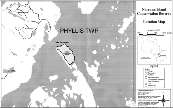
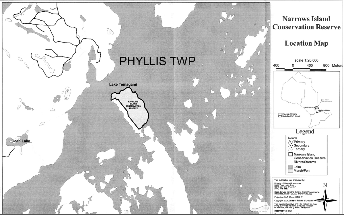
This 41 hectare parcel of Crown land is situated on Narrows Island which is located at the entrance to the southwest arm of Lake Temagami in the geographic township of Phyllis (see Location Map).
The purposes of this SCI are to:
- Provide background information and identify and describe the values of the Narrows Island Conservation Reserve
- Provide guidelines for the management of current and future activities while protecting natural, social, and cultural heritage values
This document has been prepared following the format of an SCI, also called a stewardship document. The SCI format was selected since after extensive consultation, no new issues emerged. New uses may be considered provided they meet the requirements of a Test of Compatibility (Appendix A).
This SCI governs the lands within the regulated boundary of the Narrows Island Conservation Reserve; however, to ensure MNR protection objectives are being fully met within this protected area, activities on the surrounding landscape must consider the conservation reserve’s objectives and heritage values. In addition, it is the intent of this SCI to create a public awareness that will promote responsible stewardship of protected areas and their surrounding lands in Ontario. With management partners such as Ontario Parks, industry, local governments, etc., MNR district offices will be able to pursue and advance sound environmental, Statement of Conservation Interest economic and social strategies and policies related to the protection of conservation reserves and provincial parks.
2.0 Goal and objectives
2.1. Goal of the SCI
The goal of the Narrows Island Conservation Reserves is to describe and to protect natural and cultural heritage values on public lands while permitting compatible land use activities.
2.2. Objectives of the SCI
2.2.1. Short term
- To identify the State of the Resource with respect to natural heritage values and current land use activities for the conservation reserve
- To manage the conservation reserve to protect the integrity of its natural values via specific guidelines, strategies and prescriptions detailed in this SCI
- To meet planning requirements by designing this SCI document to address the immediate planning and management needs of the conservation reserve
2.2.2. Long term
- To establish representative targets (e.g., future forest conditions) and validate the conservation reserve as a potential scientific benchmark
- To identify research/client services and marketing strategies.
- To give direction to evaluate future or new economic ventures (i.e., through use of a Test of Compatibility evaluation)
3.0 Management planning
3.1. Planning context
3.1.1. Planning area
The planning area for this SCI is the regulatory boundary of the Narrows Island Conservation Reserve. As noted earlier, planning for other activities on the surrounding landscape must consider the protection objectives and values of the conservation reserve. Any strategies noted within this plan related to the conservation reserve’s boundary or beyond, will be presented for consideration within a larger planning context such as a forest management plan (FMP).
3.1.2. Management planning context
The Comprehensive Planning Council (CPC) (a citizens advisory group, which was directed to submit land use recommendations for the Temagami Comprehensive Planning Area) recommended that Narrows Island be designated as a conservation reserve. This recommendation, along with others, was submitted in April 1996 and accepted in principle by the government of Ontario in June 1996. The decisions on the recommendations were ultimately reflected in the Temagami Land Use Plan.
Narrows Island was regulated as a conservation reserve on July 19 1997 by Ontario Regulation 259/97.
The Narrows Island Conservation Reserve is designated as Management Area 40(a), page 113 in the TLUP. By regulation under the Public Lands Act, lands within conservation reserves cannot be used for mining, commercial forest harvest, hydroelectric power development, the extraction of aggregate and peat or other industrial uses.
Traditional uses within the conservation reserve as noted in the permitted uses table of the TLUP will continue; however, the goal will be to resolve conflicts, between uses and to ensure that identified values are protected.
When considering future permitted uses and/or development(s), there are established mechanisms in place to evaluate these proposals. These include, but may not be limited to; Procedural Guideline B - Land Uses - Test Of Compatibility Policy PL 3.03.05 (OMNR 1997). Class Environmental Assessment for MNR Resource Stewardship and Facility Development Projects (OMNR 2001), with accompanying Environmental Checklist or Exemption Order MNR 26/7 for future dispositions. Other protocols may be developed that address site specific sensitivities to identified features.
Consideration for proposals pertaining to cultural resources may be screened through Conserving a Future for our Past: Archaeology, Land Use Planning & Development in Ontario, Section 3 (MCzCR, 1997) and MNR’s AOC Descriptions and Prescriptions (Cultural Heritage Resources) for the 1999-2019 Temagami FMP or its successor.
These planning tools will refine the review process once the proposal satisfies the direction and intent of the Temagami Land Use Plan.
3.2.Planning process
Once a conservation reserve is regulated, there is a need to determine the level of management planning required to fulfil the protection targets. There are two policy documents to select from; a Statement of Conservation Interest (SCI) or a Statement of Conservation Interest Resource Management Plan. An SCI is a stewardship document which generally applies to conservation reserves having no new issue(s), conflict(s) and or proposal(s) beyond what has been previously addressed during land use planning (i.e., TLUP) and, therefore, additional consultation is not needed. A Resource Management Plan (RMP) deals with more complex issues and conflicting demands placed upon a protected resource and involves full public consultation.
The guidelines for the preparation of these documents are outlined in Procedural Guideline A-Resource Management Planning (PL 3.03.05, Public Land Act). The appropriate plan is to be completed within three years of the regulation date.
For current planning purposes, the Narrows Island Conservation Reserve will be managed under the directive of a SCI. The intent of this SCI is to fulfil the commitments made under the Public Lands Act, the TLUP and other associated policies.
In July 1989, in response to growing public concern with respect to the use and management of resources within the Temagami area, MNR announced the Temagami Area Comprehensive Planning program (CPP). The resulting TLUP was based on advice of the Comprehensive Planning Council (CPC). Through this process, extensive public consultation occurred. Based on past public participation and the fact that the land use direction presented within this SCI does not differ significantly from the TLUP, additional consultation at this time is not needed.
Public consultation will be solicited during the review of any future land use proposals that would require new decisions to be made beyond the intent of the TLUP. Such amendments to the TLUP and this document or its successor will also be posted on the Environmental Bill of Rights registry (EBR).
This SCI is a policy document that will provide background information, identify values to be protected and establish management guidelines for use in the administration of the conservation reserve.
The implementation of the policy will be the mandate of the MNR at the district level, however associations with various partners may be sought to assist in the delivery. It must be noted that this SCI is a working document and it will be necessary to make revisions to it from time to time. If changes are required, they will occur through a standard process of minor or major amendments (see Section 6.5).
4.0 Background information
4.1.Location and site description
4.1.1. Location
The following table describes the location and provides administrative details of the site:
Table reformatted into a list
- Name: Narrows Island Conservation Reserve
- Site Region-Site District (Hills 1959): 4E Lake Temagami - 4E-4 Temagami
- OMNR Administrative Region/District/Area: Northeast/North Bay/Temagami
- Total Area: 41 ha
- Regulation Date: July 19, 1997 (O. Reg. 259/97)
- First Nations: Temagami First Nation. Teme-Augama Anishnabai
- OBM map sheets: 2017 5600 51900
- UTM Coordinates: 568300 5198000
- WMU: 41
- Townships: Phyllis
- Municipality: Corporation of the Municipality of Temagami
- Status: 100% Crown land
4.1.2. Site description
4.1.2.1. Physical description
The Narrows Island Conservation Reserve is a 41 hectare island parcel of Crown land that is situated in Northeastern Ontario, southwest of the town of Temagami on Lake Temagami (Phyllis Township). This conservation reserve features dominant stands of “old growth” red and white pine surrounded by an aquatic environment. The area is located within Site District 4E-4 (G.A. Hills. 1959 and Crins and Uhlig 2000), and is characterized by low-relief ground moraine typical of this region (OMNR 1992). Numerous small cliffs (up to 20 m high) and distinguishable bare rock knobs are found throughout this landscape.
The conservation reserve is bound by shoreline, with the exception of private cottage lots on the southern and western sides. It is located within the French River watershed.
The old growth red and white pine found within this conservation reserve have been aged at up to 175 years old with 50 percent stocking. The remaining forest composition includes varying mixes of white birch, poplar and white spruce. Overall, the conservation reserve exhibits just 2 landform/vegetation combinations dominated by dense coniferous forest (Thompson et al, 2001).
4.2. Administrative description
The legal boundaries of the Narrows Island Conservation Reserve were certified by the Surveyor General of Ontario in the Ministry of Natural Resources at Peterborough on the 21st of February 1997. It was passed into regulation on July 19, 1997 (O. Reg. 259/97).
4.3. History of the site
Historically, there has been little human disturbance within the boundaries of the conservation reserve. Several cottage lots adjacent to the southern and western boundaries are generally used during the summer months. These seasonal residents use the conservation reserve for hiking and nature appreciation.
Temagami First Nation (TFN) and Teme-Augama Anishnabai (TAA) members have had a long-term relationship with the Narrows Island for a variety of social and economic reasons.
In recent years, an interest by the visiting public and the scientific community has evolved for the natural and social aspects of the conservation reserve. Typically, conservation reserves are used for outdoor recreational activities, commercial use (i.e., fur and baitfish harvesting), nature appreciation, scientific and educational pursuits.
4.4. Inventories
The following table indicates what survey work has been done in the conservation reserve and what is required:
| Survey Level | Reconnaissance | Detailed | Requirement |
|---|---|---|---|
| Life Science | Noble, T.N. 1983. Life Science Report for Site Region 4E. Detailed ecological survey OMNR, 1999. Forest Resource Inventory (FRI) Mapping: Narrows Island Thompson, J.E., N Avoledo, M. Lajeunesse and J. Joyce. 2001. Life Science Checksheet: Narrows Island Conservation Reserve |
N/A | Detailed ecological survey |
| Earth Science | Aerial photography. (1988). Kor, P.S.G. 2001. Earth Science Checksheet Narrows Island Conservation Reserve. |
N/A | Not required |
| Cultural | Preliminary Review of Heritage Resources, C.P.P 1991. MNR Archaeological Prediction Modeling, 1998 (Ternaqami FMU) |
N/A | May be required |
| Recreational | Various studies on Lake Temagami. Mutch, J., 2000. Aerial Recreational Reconnaissance Survey. Hewitson, S., 2001. Recreational Checksheet: Narrows Island Conservation Reserve. |
Various studies on Lake Temagami. |
|
| Other | N/A | N/A |
|
5.0 State of the resource
5.1. Representation
The Narrows Island Conservation Reserve is comprised of low-relief bedrock overlain by a thin veneer of stony till. Bedrock consists of a diabase in the form of a large dike, an offshoot of the more widespread Nipissing diabase sills in the region. Minor occurrences of the Gowganda Formation greywacke are found on the west shore of the island. The overall geology of this conservation reserve is typical of the region and is well represented in other protected areas. This representation is therefore considered locally significant (Kor, 2001).
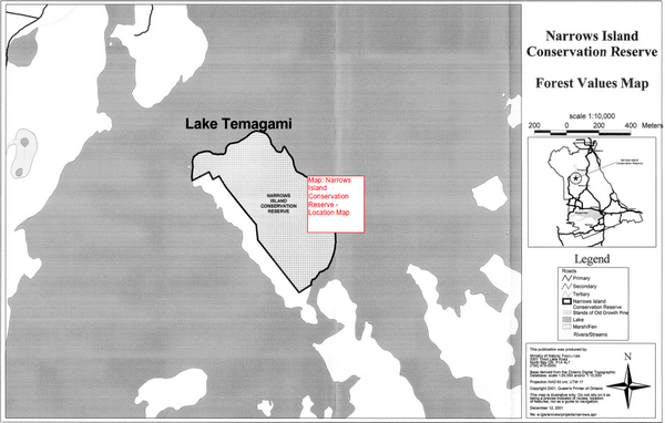
Significant stands of old growth red and white pine are found throughout the conservation reserve. Other forest stands present include varying mixes of white birch, poplar and white spruce (see Forest Values Map).
Finally, the Narrows Island Conservation Reserve is surrounded by Lake Temagami, which contains several warm and cold water species of fish and their associated habitats.
5.1.1. Quality of the representation
The quality of the representation or the current characteristics of the natural features found within a conservation reserve are as important as the overall representative features that are being protected. A number of factors are considered in evaluating the quality of a conservation reserve’s representative uniqueness. They include diversity, condition, ecological factors, special features and current land use activities.
a) Diversity:
The presence of the large, dominating pine cover, and the lack of wetland communities, limits the level of diversity found in this conservation reserve. As mentioned, only 2 landform/vegetation combinations have been identified in this conservation reserve. Future investigative studies may discover additional plant communities associated with such habitats as rock outcrops, valleys, ridges, and a small black spruce stand found on the western side of the island (Thompson et al, 2001).
b) Condition:
This conservation reserve is located among very healthy red and white pine stands. There is no evidence of significant human or natural disturbances within or adjacent to the conservation reserve. Some small, low impact trails traverse the conservation reserve and most of these run directly to private cottages on the western side of the island. Narrows Island Conservation Reserve is located in close proximity to popular Lake Temagami canoe and snowmobile routes.
c) Ecological factors:
Approximately 60 percent of the conservation reserve’s boundary follows the shoreline of Narrows Island. This natural boundary will help buffer the conservation reserve from adjacent land uses over time. The western boundary is vectored and bisects the old growth values that require protection. Future planning will have to consider these values to ensure protection (Thompson et al, 2001).
d) Special features:
This conservation reserve contains a number of notable features, which possess varying degrees of significance. These features include:
- Old growth stands of red and white pine up to 175 years old
- Coldwater lake fishery (Lake Temagami)
- A significant spawning site for lake trout
e) Current land use activities:
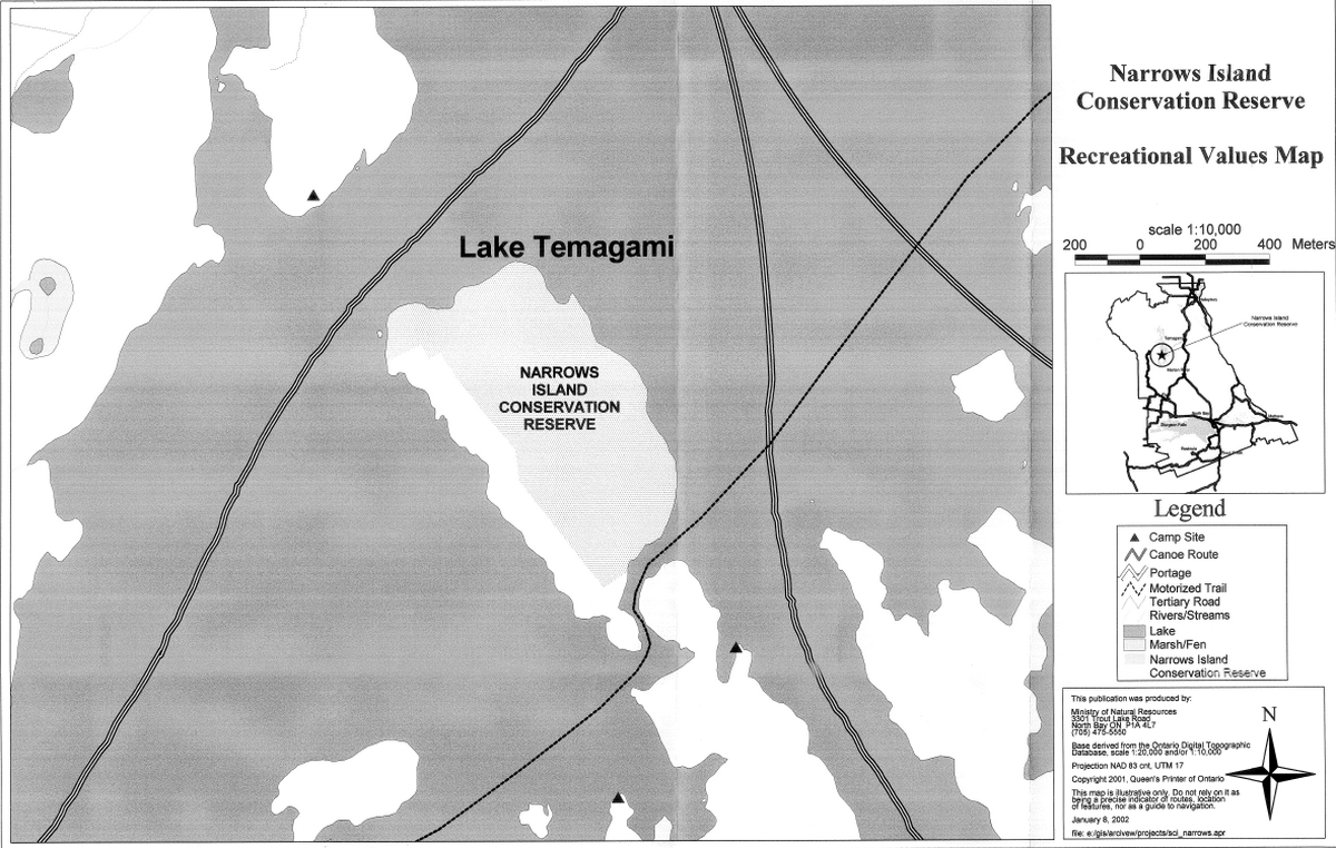
The conservation reserve is limited to water access with the majority of shoreline easily accessible to watercraft. Several of Temagami’s established canoe routes run through this section of the lake but no campsites are located on Narrows Island.
Other recreation activities associated with the conservation reserve are nature appreciation, interpretation, hiking, wildlife viewing, hunting and fishing. Low intensity outdoor nature appreciation and education will be encouraged, and is expected to involve self-guided tours by various interest groups. The entire conservation reserve has high cultural heritage value for the TFN and TAA. There is a known heritage cave and rock knob formations located on the eastern side of the island.
There have been no significant human or natural disturbances within the conservation reserve, however there are cottage lots immediately adjacent, along the western shore and southern point of Narrows Island. The few non-motorized trails present in this conservation reserve are underdeveloped and have probably been created by Narrows Island cottage owners. In the winter cross-country skiing and snowshoeing would be excellent ways to explore the conservation reserve. Regular maintained snowmobile trails exists on the lake to the north and south of Narrows Island.
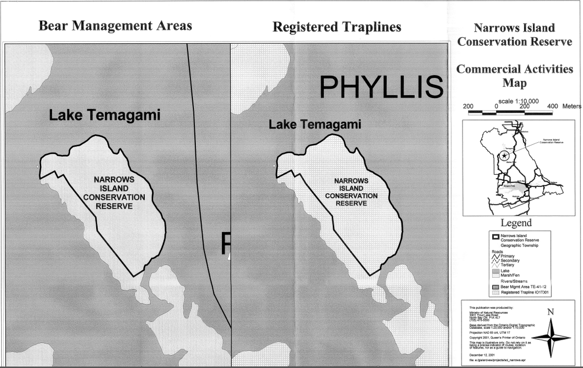
There is one First Nation Cooperative fur trapline and one Bear Management Area (BMA) that overlap the conservation reserve. These commercial activities are not intense and do not conflict with other interests. Some limited upland game hunting by local residents also occurs within the conservation reserve.
Summary:
The Narrows Island Conservation Reserve contains provincially significant old growth red and white pine communities. The conservation reserve’s overall diversity, physical condition, design, current and potential recreational and interpretive values are considered significant. Finally, natural linkages connect the site to the surrounding aquatic landscapes found within the Temagami Region. This illustrates the Narrows Island Conservation Reserve’s importance to the provincial parks and protected areas system.
5.2. Social/economic interest in the area
a) Linkage to local communities:
The Narrows Island Conservation Reserve consists entirely of Crown land and is easily accessible to the public by water. Located on Lake Temagarni this area is a popular destination for travelers and seasonal residents. As a result of the closure of the Sherman Mine and the Wm. Milne Sawmill in the early 1990s, tourism has become a major economic driver in the Temagami area with scenic landscapes and the natural environment as major attractions.
The Narrows Island Conservation Reserve is well suited for outdoor recreation, nature appreciation and educational opportunities. In a regional context, the conservation reserve offers natural features that generate interest in ecotourism, recreational and tourism markets.
Currently the conservation reserve is available for hunting, fur harvesting, hiking, camping, nature appreciation (i.e., viewing of old growth forests, wildlife observation, and photography), cross-country skiing and snowshoeing.
There are several local outdoor recreational outfitting companies and tourist lodges that may decide to use or expand their current use of the Narrows Island Conservation Reserve.
Outdoor education and scientific research potential in the conservation reserve is significant. Future development of the trail system may include an interpretive trail and guide. The red and white pine old growth stands are excellent examples of a pristine forest, which provides opportunities for viewing old trees, wildlife snags, sucessional communities, etc.
b) Heritage estate contributions:
The Narrows Island Conservation Reserve contributes to the province’s parks and protected areas system through its regulation, representation and the longterm management of its natural heritage values.
By allocating these lands to the parks and protected areas system through regulation, the province has ensured a certain level of permanence by distinguishing the conservation reserve and its values from the larger general use or more extensively managed landscape. In addition, its natural features are, and will be available for present and future generations to enjoy and explore.
The representation of the Narrows Island Conservation Reserve’s values make a number of contributions to the province’s natural heritage estate. Firstly, its old growth red and white pine communities contribute significantly to the provincial parks and protected areas system. Secondly, the conservation reserve’s location, design and features make a distinctive contribution to quality recreational experiences that include hiking trails. Although rather small in size, its shape and natural boundaries (e.g., shorelines) buffer adjacent land use activities and allow for a certain level of remote back-country opportunities and experiences. Lastly, its connection to Lake Temagami considerably adds to the over-all value of this conservation reserve.
Long-term management must consider public access to the conservation reserve its protection objectives, and commitments made in the TLUP. Future managers will have to balance between maintaining the quality of the current natural features and the needs of recreational and other users.
c) Aboriginal groups
The Narrows Island Conservation Reserve is located within the ancestral homeland, known as Daki Menan, of the TFN and TFA. Approximately 150 First Nation members reside on the Bear Island Reserve, located on Lake Temagami. A number of pre-historic and historic archeological sites have been documented in the area. These and other cultural heritage resources found within Daki Menan are of great importance to these two groups.
In 1999, Ontario agreed to enter into formal negotiations with the TFN and the TAA on the basis of outstanding treaty obligations consistent with the Supreme Court of Canada’s 1991 Bear Island decision. These negotiations are scheduled to conclude in December 2002.
d) Mining industry:
Through an Order-in-Council dated December 19, 1911, islands in Lake Temagami were withdrawn from staking under the Mining Act, this withdrawal included Narrows Island.
All mining rights within the protected area of Narrows Island were later withdrawn based on the boundaries established in the TLUP prior to the lifting of the land caution. In 1997 minor boundary refinements were required primarily to define the conservation reserve on the ground for regulation purposes. The mining rights were re-withdrawn in January 2001 to be consistent with the regulated boundaries.
e) Forest management
No commercial timber harvesting is permitted in conservation reserves. Forest activities on the adjacent landscape are guided by the Forest Management Plan (FMP). Based on the current plan (1999-2004), the following provisions apply:
Harvesting, renewal and maintenance are permitted up to the conservation reserve boundary. Where the integrity of the boundary may be affected by blowdown (e.g., based on slope, aspect relative to prevailing winds, soils, species, size and type of adjacent cuts, etc.) the need for additional protection is to be determined during the development and planning of the Annual Work Schedule.
No roads or landings are permitted within 100 m of the boundaries of nonwaterway conservation reserves, except where it can be demonstrated no alternative alignments are available and with MNR approval. Roads will be planned to minimize potential access to conservation reserves (e.g., perpendicular to conservation reserve boundaries).
Presently there is no Sustainable Forestry License (SFL) within or adjacent to the conservation reserve. The Crown currently manages the Temagami Forest Management Unit. The North Bay District office (Temagami Area) administers Forest Resource Licensing (FRL) in this unit.
f) Utilities
There are no commercial utilities located within the regulatory boundaries of the conservation reserve.
5.3. Natural Heritage Stewardship
Preliminary analysis of the life science targets based on landform/vegetation combinations has shown that the conservation reserve contains a minimum of two landform vegetation combinations dominated by dense coniferous forest over ground moraine (OFRI, 1994). The most significant features include old growth stands of red and white pine aged at up to 175 years old, the coldwater fishery associated with Lake Temagami and a significant spawning site for lake trout.
A recent aerial reconnaissance survey showed no significant site disturbance due to timber harvesting, fire, insect, wind throw, wildlife damage, ice storms or other natural disturbances.
Water levels on Lake Temagami are controlled by Ontario Hydro and fluctuate throughout the year.
5.4. Fisheries and wildlife
There have been no detailed wildlife studies undertaken within the conservation reserve, with the exception of some values monitoring. The importance of the conservation reserve to wildlife species has yet to be determined, particularly for those species, and habitats thereof, that may be vulnerable, threatened or endangered. Numerous aquatic habitat inventories have taken place on Lake Temagami over the years.
Should any vulnerable, threatened or endangered (VTE) wildlife and/or plant species be identified within or adjacent to the conservation reserve; their value will be protected. Although the species may be identified as residing within the conservation reserve, their location will remain undisclosed.
5.5. Cultural Heritage Stewardship
There is one documented and registered site (MCzCR) linked to historical travel routes and habitation in the Narrows Island Conservation Reserve. Areas of high potential cultural heritage have been mapped through a predictive modeling process. These areas are linked to shorelines and known historic travel routes (see Cultural Heritage Values Map).
5.6. Use/existing development
The Highway 11 corridor is the major access artery to the Lake Temagami area. Crown land recreation is very prevalent in this region. Lake Temagami supports numerous summer homes and a wide range of recreational opportunities and is a focal point for other backcountry destinations and experiences.
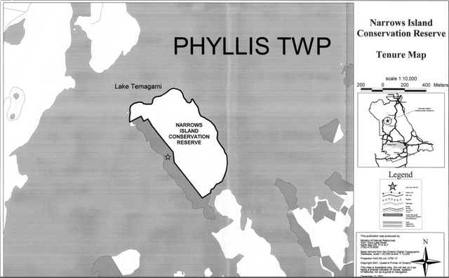
The conservation reserve’s boundaries exclude 22 private lots: the majority of which are directly located adjacent to conservation reserve’s western boundary and abutting Lake Temagami (see Tenure Map).
There is no other form of tenure in the conservation reserve other than legal agreements with the registered native fur trappers and the bear management area operator.
Traditional uses within the conservation reserve will continue to be permitted; however, the goal will be to resolve conflicts regarding incompatibility between uses and to ensure that identified values are adequately protected. Existing uses are as defined in Section 5.1.1(e).
Underdeveloped trails are located within the conservation reserve, these trails are generally found in areas of old growth forest.
5.7. Commercial use
Presently, the only commercial activities that may be conducted within this conservation reserve are fur harvesting and bear guiding. It is unlikely that these uses are occurring at the present time.
5.8. Tourism/recreation use/opportunities
Current uses of this conservation reserve have been described in Section 5.1.1(e). Presently, there is no known infrastructure supporting any recreational or commercial activities within the conservation reserve’s boundaries.
During the planning phase for the conservation reserve, no new recreational, ecotourism or tourism initiatives were brought forward for consideration.
5.9. Client services
Presently, client services include district responses to public inquiries. No formal information or interpretive facilities currently exist within the conservation reserve.
6.0 Management guidelines
6.1. Management planning strategies
Commitments identified in previous planning documents TLUP and current legislation (Policy 3.03.05 PLA) will form the basis for land use decisions within the conservation reserve. Management strategies for these uses must consider the short and long-term objectives for the conservation reserve. For current information on permitted uses refer to the Crown Land Use Atlas.
Proposed uses and development will be reviewed on a case-by-case basis. A Test of Compatibility, (Procedural Guideline B - Land Uses (PL 3.03.05)) must be passed before they are deemed acceptable. The emphasis will be on ensuring that the natural values of the conservation reserve are not negatively affected by current and future activities. Therefore any application for new specific uses will be carefully studied and reviewed. The Ministry, partner organizations and/or proponents may undertake such studies.
6.2 State of the resource management strategies
The development of this SCI and the long term management and protection of Narrows Island Conservation Reserve will be under the direction of the MNR’s North Bay District, Temagami Area Supervisor. The following management strategies have been created to achieve the goal and objectives stated earlier in this management document:
Social/economic
- Management direction will aim to maintain and develop social and economic benefits to the local community where practical
- Local partnerships may be solicited to participate in the delivery of certain objectives identified in this SCI
- Educational opportunities will be developed and encouraged in order to create an awareness of natural systems in the area
Natural Heritage Stewardship
- With the exceptions of fire suppression and selective forest insect and disease control, the management intent for the Narrows Island Conservation Reserve is to allow for natural ecosystems, processes and features to operate undisturbed with minimal human interference while providing educational, research and recreational activities
- Forest ecosystem renewal and maintenance as stated for this conservation reserve under the TLUP will only be entertained via a separate vegetative management plan
- Prescribed burning will be conducted only under the direction of the provincial fire strategy and authorized for the conservation reserve under a separate vegetative management plan. Prescribed burning may be utilized if deemed necessary to emulate natural disturbances and renew forest communities, prepare seed beds for research and/or education purposes or to meet additional objectives determined within a separate vegetative management plan
- Defining compatible uses, enforcing regulations and monitoring and mitigating issues will protect all earth and life science features
- New energy transmission, communication and transportation corridors or resource roads or construction of facilities are discouraged within the boundaries of the conservation reserve
- Industrial activities such as; commercial timber harvest, prospecting and mining and new hydro generation will not be permitted within the boundaries of the conservation reserve
- The introduction of exotic and or invasive species will not be permitted
- The collection/removal of vegetation and parts thereof will not be permitted; however, subject to a Test of Compatibility, the Area Supervisor may authorize the collection of plants and/or parts for purposes of rehabilitating degraded sites within the conservation reserve, or the collection of seeds for maintaining genetic stock and/or research
- The rehabilitation of damaged ecosystems will occur whenever possible to maintain bio-diversity
- Permits for fuel-wood will not be issued
- All wildfire occurrences will be considered a high priority and will actively be suppressed until such time as policy directions change
- MNR will provide leadership and direction for maintaining the integrity of this conservation reserve as heritage estate
- Programs may be developed to control forest insects and diseases where there is a concern that significant values may be compromised. Remedies must focus on the outbreak or infestation. Biological solutions should be applied whenever possible. Vegetation maintenance of the existing utility corridor should be encouraged to follow this process where and when feasible
- Detailed ecological surveys concerning ground vegetation and additional plant values assessment-especially concerning species at risk is warranted. Additional plant science inventory should be linked to future recreational needs and possibly regional gap analysis approaches. Assessments should follow future direction and methods established through MNR’s Inventory, Monitoring and Assessment Reporting (IMAR) program (see section 6.4)
- Research, education and interpretation will be encouraged to provide a better understanding of the management and protection of the natural heritage values and will be fostered through local and regional natural heritage programs initiatives and partnerships
- Other activities that do not pass a Test of Compatibility will be prohibited (MNR Policy 3.03.05, 1997)
Fisheries and wildlife
- Fish and wildlife resources will continue to be managed in accordance with policies and regulations prevailing in the area and under the direction of the Temagami Area Supervisor. Provincial legislation and policy will dictate management and enforcement objectives for this area
- Management direction will aim to verify species present, ecological function and habitat requirements
- Additional fish and wildlife population and habitat assessments, especially for species at risk, are warranted
- Any fish and wildlife inventory may require a regional gap analysis approach
- Inventories, assessments or monitoring programs should follow direction and methods established through MNR’s IMAR program and be linked to district sustainability objectives and initiatives or future recreational needs. (see section 6.4)
- Hunting and angling will be permitted within this conservation reserve
- Area of Concern (AOC) prescriptions for the protection of fish and wildlife values, developed for forest management purposes, will be used as a guide when considering proposed activities/developments in the conservation reserve
Cultural heritage
- Protection of these values will be maintained
- Documented sites will be checked periodically for signs of degradation. Additional sites will be documented as encountered
- Development, research and education proposals may be considered in accordance with the Test of Compatibility; Conserving a Future for our Past: Archaeology, Land Use Planning & Development in Ontario, Section 3 (MCzCR, 1997) and MNR’s AOC Descriptions and Prescriptions (Cultural Heritage Resources) for the 1999-2019 Temagami FMP or its successor
- Research/education to provide a better understanding of the management and protection of cultural heritage values will be encouraged
Land use/existing development
- Existing land uses and development within the conservation reserve that conflict with the protection objectives a (Test of Compatibility) will be identified and discontinued if impacts can’t be mitigated. Similarly, uses in adjacent lands will be reviewed. If they are found to impact on the conservation reserve, mitigation measures will be explored
- There will be no new motorized trail development; however, non-motorized trail development may be permitted only if the activity passes a Test of Compatibility
Commercial use
- Existing commercial uses such as fur harvesting and the operation of the bear management area will be permitted. Such activities will continue to be monitored in order to ensure they do not unduly deplete natural resources and that they impose a minimal impact on the features identified for protection
- Trapline cabins will not be permitted
- Commercial enterprises offering ecotourism experiences will be encouraged, providing these activities are low in intensity and are compatible with other uses
Aboriginal interests
- Aboriginal and treaty rights will continue to be respected throughout the management of this SCI. Any future proposal(s) and or decision(s) that have potential impact(s) on individual aboriginal values and or communities will involve additional consultation with the affected aboriginal groups
Tourism/recreation
- The earth and life science features and their protection, shall be the overall theme for tourism
- The conservation reserve should also be portrayed as providing backcountry experiences
- Small-scale infrastructures for enhancing tourism and recreation (i.e., warmup shelter) may be considered, providing they pass a Test of Compatibility and other review requirements
- Main base tourism development (lodges) will not be permitted
- Conflict resolution between recreational uses will be a priority. This will be achieved by adhering to the objectives of this SCI with input from relevant user groups
- The level of safety and compatibility between activities will determine permitted uses (i.e., Test of Compatibility)
- Low-impact camping may be permitted along the shoreline
- Degradation of cultural heritage sites will not be permitted and current and future use will be monitored and if deemed necessary, camping may be prohibited at certain sites in order to protect these values
Client services
- Information regarding the Narrows Island Conservation Reserve may be delivered from different sources, however MNR will be the lead agency for responding to inquiries regarding access, land use, values and recreation opportunities
- A management agreement may be pursued with an appropriate partner to share responsibilities for information services and the delivery of other aspects of this SCI
6.3 Specific feature/area/zone management strategies
Presently there are no specific management strategies in place for subcompartments within the conservation reserve.
With the exception of fire suppression, the old growth pine ecosystem will be allowed to develop in a natural, undisturbed manner.
If, during the course of conservation reserve monitoring it is deemed necessary to regulate access or uses in certain areas, management zones may be developed. These zones will facilitate permitted/restricted activities for the protection of certain features or to resolve conflicts between uses. Zone management will endeavor to compliment linkages to areas and uses outside the conservation reserve. The creation of management zones will require additional planning beyond this SCI, public consultation and an eventual plan amendment if accepted.
6.4. Promote Inventory, Monitoring and Assessment Reporting (IMAR), and research
There are many opportunities to study and explore the natural systems in the conservation reserve. Since there has been little interference from “outside influences”, some features may be observed in a relatively undisturbed state.
New developments such as campsites, privies, trails or developed access points will not be considered until a Test of Compatibility is conducted. The Test of Compatibility or environmental screening process could include a review of the demand for structures or may require more detailed life or earth science or cultural information and possibly a more detailed management plan.
Non-destructive research will be promoted as an asset for procuring an understanding of the natural features and processes of Narrows Island Conservation Reserve.
6.5. Implementation, and plan review strategies
This Statement of Conservation Interest will be reviewed on an ongoing basis. Implementation of the SCI will include monitoring activities to ensure adherence to management guidelines. A full review will coincide with the review of the Temagami Land Use Plan (next review- 2006) and will be done every ten years thereafter.
Implementation of the SCI and management of this conservation reserve are the responsibility of the Temagami Area Supervisor. Partnerships may be pursued to address management needs. If changes in management direction are needed at any time, the significance of the changes will be evaluated. Minor changes, which do not alter the overall intent of this SCI, may be considered and approved by the District Manager without further public consultation and the SCI will be amended accordingly.
In assessing major changes, the need for a more detailed resource management plan (RMP) will first be considered. Where a RMP is not considered necessary or feasible, a major amendment may be considered with public consultation. Such amendments will also be posted on the Environmental Bill of Rights (EBR) registry. The Regional Director has approval authority for any major amendments for this SCI.
6.6. Marketing strategies
Messages should focus on the area’s accessibility, natural heritage representation, recreation opportunities and the “Temagami Experience” in general. Research and education is a theme that should be incorporated in all promotional strategies.
Partnerships may be fostered to aid in the delivery of this component.
References
Crins, W.J. and P.W.C. Uhlig. 2000. Ecoregions of Ontario: Modifications to Angus Hills’ Site Region and Districts- Revisions and Rationale.
Hills, G.A. 1959. A Ready Reference to the Description of the Land of Ontario and its Productivity. Ontario Department of Lands and Forests, Division of Research, Maple, Ontario. 140 pp.
Kor, P.S.G. 2001. Earth Science Checksheet: Narrows Island Conservation Reserve.
Noble, T.N. 1983. Life Science Report for Site Region 4E. Ontario Ministry of Natural Resources, Sudbury, 90 p. Appendices. 4E Biophysical Map Sheets (1:250,000).
Ontario Ministry of Citizenship, Culture and Recreation. 1997. Conserving a Future for Our Past: Archaeology, Land Use Planning and Development in Ontario. 42 pp.
Ontario Ministry of Natural Resources. 2001. A Draft Class Environmental Assessment For MNR Resource Stewardship and Facility Development Projects. 76 pp.
Ontario Ministry of Natural Resources. 1999. Forest Resource Inventory (FRI) Mapping: Narrows Island Conservation Reserve. Ontario Ministry of Natural Resources, North Bay.
Ontario Ministry of Natural Resources. 1997. Public Lands Directive Manual: Natural Heritage- PL 3.03.05.
Ontario Ministry of Natural Resources. 1997. Temagami Land Use Plan for the Temagami Comprehensive Planning Area.
Ontario Ministry of Natural Resources. 1991. Temagami Comprehensive Planning Program (Heritage Component)- Preliminary Review of Heritage Resources. Ontario Ministry of Natural Resources. 1988. OMNR: Aerial Photos (1:20,000).
Ontario Ministry of Natural Resources. 1987. Assessment of Representative and Special Earth Science Resource Features of the Temagami Planning Area. Volume 2.
Hewitson, S. 2001. Recreational Inventory Checksheet: Narrows Island Conservation Reserve.
Thompson, J.E. 2000. Aerial Reconnaissance Survey: Narrows Island Conservation Reserve.
Thompson, J.E., M. Lajeunesse, J. Joyce and N. Avoledo. 2001. Life Science Checksheet: Narrows Island Conservation Reserve.
Appendix A – Procedural Guideline B - Land uses Test of Compatibility
Public Lands Act Policy PL 3.03.05 (procedure 3.03.05)
The Conservation Reserve policy provides broad direction with regard to the permitted uses. The policy provides only an indication of the variety of uses that will be considered acceptable in Conservation Reserves. The only caution is that “any new uses, and commercial activities associated with them will be considered on a case by case basis, they must pass a test of compatibility to be acceptable”. What does a “test of compatibility” mean?
An examination of this must start from the premise of why an area is set aside - specifically, its representative natural heritage values. Criteria are then identified to guide compatibility considerations. These criteria apply to the long-term acceptability of both existing uses and new uses.
-
Conformity to SCI: SCI describe values for which an area has been set aside and the range of appropriate uses that will be permitted in the area. SCI may also speak to the acceptability of other “new” uses currently not occurring in the area.
The first “test” is: “do proposed new land uses and/or commercial activities conform to the direction of the SCI for the Conservation Reserve? Would the new use(s) depart from the spirit of appropriate indicator land uses in the SCI?"
- Impact Assessment: If the proposed use(s) pass test one it is important to determine their impact on the area before they are approved. This should include the following:
- Impact on natural heritage values: “will the new use(s) impact any natural values in the area? If so, how and to what degree? Is it tolerable?”
- Impact on cultural values: “will the new use(s) impact any historical or archaeological values in the area?”
- Impact on research activities: “will the new use(s) affect any research activities in the area?”
- Impact on current uses: “will the new use(s) have any negative impact on the array of current uses?”
- Impact on area administration: “will the new use(s) increase administrative costs and/or complexity?” (For example, the cost of area monitoring, security and enforcement)
- Impact of accommodating the use outside the Conservation Reserve: “Could the use(s) be accommodated as well or better outside the Conservation Reserve?”
- Impact on socio-economics of the area: “will the use(s) affect the community(ies) surrounding the area in a positive or negative way?” (for example, will the new use make the area less remote thereby affecting a local tourism industry that is dependent on the area’s remoteness for its appeal)?
- Impact on area accessibility: “does the new use(s) give someone exclusive rights to the area or a portion of the area to the exclusion of other existing uses?”
Appendix B – Glossary of terms
- Annual Work Schedule
- one-year schedule of forestry operations (i.e. harvest, renewal, tending, road planning etc.)
- Ecotourism
- responsible tourism that considers the natural heritage values within the conservation reserve and their sustainability as well as taking into account the interests of local communities.
- IMAR
- integrated, ministry-wide framework for Inventory, Monitoring, Assessment, and Reporting that supports the management of our natural resources in an ecologically sustainable way.
- Land Caution
- registered on 110 townships in the Temagami area in August of 1973, which prevented first registration of tenure documents by the Crown. The documents included patents, leases, and easements. A court ruling in 1996 ended the caution.
- Vector
- series of distinct points, which makes up a line that defines a portion of a conservation reserve’s boundary, this artificial boundary is created with the use of Geographic Information System (GIS) computer software.
Narrows Island Conservation Reserve - Location Map
Enlarge Narrows Island Conservation Reserve - Location Map
Narrows Island Conservation Reserve - Forest Values Map
Enlarge Narrows Island Conservation Reserve - Forest Values Map
Narrows Island Conservation Reserve - Recreational Values Map

Enlarge Narrows Island Conservation Reserve - Recreational Values Map
Narrows Island Conservation Reserve - Fish & Wildlife Values Map
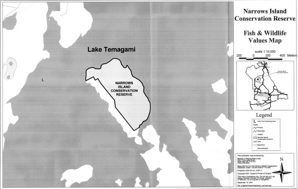
Enlarge Narrows Island Conservation Reserve - Fish & Wildlife Values Map
Narrows Island Conservation Reserve - Cultural Heritage Values
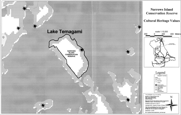
Enlarge Narrows Island Conservation Reserve - Cultural Heritage Values
Narrows Island Conservation Reserve - Commerical Activities Map

Enlarge Narrows Island Conservation Reserve - Commercial Activities Map
Narrows Island Conservation Reserve - Tenure Map