North Channel Inshore Provincial Park Management Statement
This document provides policy direction for the protection, development and management of North Channel Inshore Provincial Park and its resources.
Approval statement
I am pleased to approve this Interim Management Statement for North Channel Inshore Provincial Park. Ontario’s Living Legacy Land Use Strategy (1999) identified this area as a waterway class provincial park. North Channel Inshore Provincial Park was regulated November 20, 2002 (O. Reg. 311/02) under the Provincial Parks Act.
This Interim Management Statement provides direction for the protection and custodial management of North Channel Inshore Provincial Park.
Paul Bewick
Zone Manager
Northeast Zone
Ontario Parks
Date: December 12, 2006
1.0 Introduction
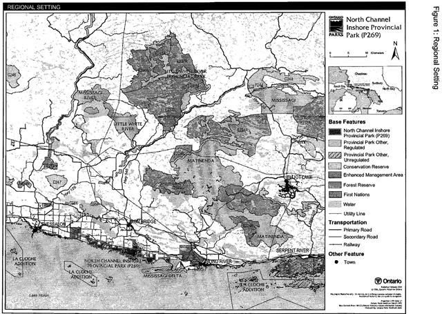
North Channel Inshore Provincial Park is located along the shoreline of the North Channel of Lake Huron (Figure 1). The park is comprised of five parcels of Crown land separated by private lands. The park is within Bright Additional, Bright, and Thompson townships, in the Municipality of Huron Shores as well as, Striker Township in the Town of Blind River, and Long Township in the municipal Township of the North Shore.
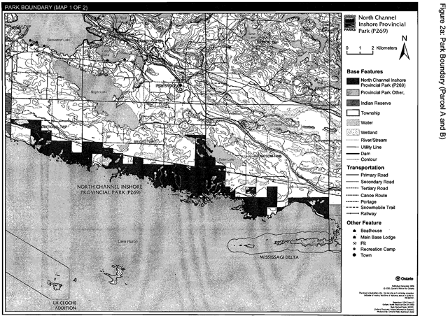
The largest of the parcels, located in Bright Additional, Bright, and Thompson townships, includes approximately 3,344 hectares (Figure 2a, Parcel A). This parcel includes Parts 1-13 of the Regulation Plan for this park. The most western boundary of this section of park is located at the township line between Bright Additional and Thessalon Indian Reserve No. 12. The boundary of this parcel is highly influenced by adjacent private land. The Canadian Pacific Railway corridor crosses through this area as well. This portion of the park also includes the following natural heritage areas: Dayton Beach Ridge and Swale and Foul BightRidge and Swale. As per Ontario’s Living Legacy Land Use Strategy (1999), these particular areas are to be protected as natures reserve zones within the park.
Another small portion of park is located just east of the largest section of park (Figure 2a, Parcel B). This portion includes approximately 251 hectares in Parts 14 and 15 of the Regulation Plan for the park. The eastern boundary of this parcel lies at the Thompson and Cobden township line.
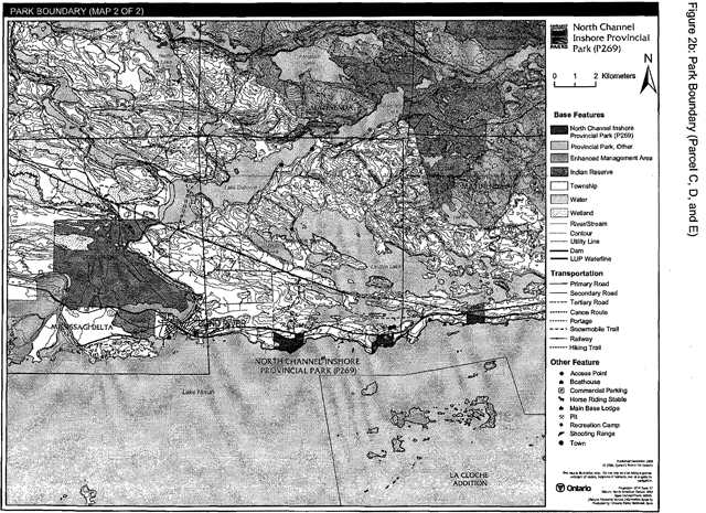
The third parcel of park is located in Striker Township (Figure 2b, Parcel C). This parcel includes approximately 94 hectares and is located in Lots 6 and 7 of Concession 1 in Parts 16-19 of the Regulation Plan for this park. The Canadian Pacific Railway (CPR) travels along the northern boundary and bisects the eastern area of this portion of the park.
Another small parcel of park, also located in Striker Township, includes approximately 49 hectares of park (Figure 2b, Parcel D). This parcel is located in Lots 1 and 2 of Concession 1 in Parts 20-23 of the Regulation Plan for this park. This parcel of park is bisected by the Canadian Pacific Railway. Highway 17 travels along the northern boundary of this part of the park.
The smallest parcel of park is approximately 28 hectares and is located in Lot 8 of Concession 2 of Long Township (Figure 2b, Parcel E). This parcel of park in Parts 24 and 25 of the Regulation Plan is bisected by Highway 538 in its northwest corner.
This park was regulated as a waterway class park under the Provincial Parks Act (O. Reg. 311/02) in November of 2002. The regulated boundary of this provincial park encompasses a total of 3,762 hectares. Waterway parks are based on outstanding recreational water routes and are meant to provide high quality recreational and educational experiences.
1.1 Objectives
North Channel Inshore Provincial Park will be managed according to provincial park objectives:
Protection: To protect provincially significant elements of the natural and cultural landscapes of Ontario.
Recreation: To provide provincial park outdoor recreation opportunities ranging from highintensity day-use to low-intensity wilderness experiences.
Heritage Appreciation: To provide opportunities for exploration and appreciation of the outdoor natural and cultural heritage of Ontario.
Tourism: To provide Ontario’s residents and out-of-province visitors with opportunities to discover and experience the distinctive regions of the Province.
Figure 1: Regional setting
Enlarge 1: Regional setting (PDF)
Figure 2a: Park boundary (Parcel A and B)
Enlarge figure 2a: Park boundary (Parcel A and B) (PDF)
Figure 2b: Park boundary (Parcel C, D, and E)
Enlarge figure 2b: Park boundary (Parcel C, D, and E) (PDF)
2.0 Management context
The purpose of this Interim Management Statement (IMS) is to provide direction to ensure the custodial management of park resources. Future park planning may be undertaken as required to provide direction on significant decisions regarding resource stewardship, development, operations and permitted uses.
Park management will follow direction from:
- Provincial Parks Act (1990) and regulations
- Ontario Provincial Parks Planning and Management Policies (OMNR 1992)
- Ontario’s Living Legacy Land Use Strategy and policy clarification amendments (OMNR 2000) and related direction
- Crown Land Use Policy Atlas (OMNR 2004a)
In addressing custodial management obligations to protect park values and ensure public health and safety, Ontario Parks will ensure that policy and Environmental Assessment Act (1990) requirements are implemented.
2.1 Environmental assessment
As a part of the Ontario Ministry of Natural Resources (MNR), Ontario Parks is a public sector agency which is subject to the Environmental Assessment Act. Park management will be carried out in accordance with legislation, policies and guidelines that are required under A Class Environmental Assessment for Provincial Parks and Conservation Reserves (OMNR 2005).
3.0 Park features and values
North Channel Inshore Provincial Park is made up of an east to west series of related shoreline habitats on the southern Shield and within Ecodistrict SE-1.
3.1 Geological features
THe majority of North Channel Inshore Provincial Park is located within the western Abitibi Subprovince in the Archean Superior Province of the Precambrian Shield. The remainder of the park is underlined by the western part of the Paleoproterozoic Huronian Supergroup of the Southern Province (Frey and Duba 2003).
The surficial deposits in the park are thin, sandy ground moraine till and larger areas of glaciolacustrine sand, till and clay. The till is found in bedrock pockets, deposited by the southsouth-westward advancing Superior Lobe of the Late Wisconsinan continental ice sheet (Frey and Duba 2003).
The prolonged glacial lake activity (Lake Algonquin, Lake Stanley, and Lake Stanley-Nipissing) exposed extensive bedrock areas adjacent to the Lake Huron shoreline and the tops of interior outcrops. It also resulted in several areas of numerous raised beach ridges (Frey and Duba 2003). The most notable of these stranded beach ridges occur at Dayton Beach, Bright Point, and Foul Bight (Morris 2003).
The representation of the numerous pre-Lake Huron shoreline beach ridges within North Channel Inshore Provincial Park is provincially significant within the context of the Ontario Provincial Parks system (Frey and Duba 2003).
3.2 Biological features
This provincial park protects the largest remaining undeveloped section of the North Channel of Lake Huron shoreline in Ecodistrict 5E-1. North Channel Inshore Provincial Park supports interior forest habitat, which is developed elsewhere on the North Channel coast in Ecodistrict 5E-1. These forests provide excellent migratory and breeding habitat for bird species and some small mammal species (Morris 2003).
North Channel Inshore Provincial Park encompasses several areas that were identified as candidate life science Areas of Natural and Scientific Interest (ANSI). These areas were identified as being either provincially or regionally significant and are now important features within this park.
Dayton Beach Ridge and Swale is located at the western end of the park, along the shoreline of the North Channel east of Thessalon between Thessalon Indian Reserve and Dayton Station. A series of raised beaches and wet swales extend inland to the Nipissing Bluff. The ridges reflect minor stops as the lake water levels adjusted to the present shoreline. The immediate shoreline area includes small bedrock headlands and sand beaches that are barren of vegetation. Backing the barrens is the most recently sand ridge that is covered by shrub thickets, meadows and upland forest. Beach Pea and Bear-Berry, which are regionally significant, and American Beach Grass, which is a provincially significant Great Lakes coastal ’meadow’ species, are located on the most recent ridges (Bergsma 1998a).
Foul Bight Ridge and Swale is located along the North Channel shoreline west of Mississagi Bay and to the east of the Siccorde Point Islet Marsh site. The focal point here is a series of low gradient, closely spaced raised beach ridges and intervening swales which back the small bay known as Foul Bight and extend inland to the Nipissing bluff. The raised beach ridge and swale pattern is subtle and even superficial for a short distance inland from the shoreline. They are superficial in that the beach lines, or strands, are buried by a shallow peat mantle but whose subsurface existence is reflected by surface vegetation which is mainly eastern white cedar and black spruce swamp. Further inland, where the gradient increases, the beach ridges erupt from the peat with their more typical curvilinear sand and gravel character. The swale wetland communities in the section are very narrow and form an intricate complex with the ridges. On steeper gradients the ridges abut one another and the swales disappear, while where the gradients flatten out again on the upslope the ridge and swale pattern becomes more evident and the swales wetter. Beyond that is a large area of relatively flat forested swamp which extends back to and abuts the Nipissing Bluff (Bergsma 1998b).
Bright Point Wetlands is located along the shoreline of the North Channel east of Dayton Station. It is one of several large and undisturbed wetland areas along this stretch of the shoreline. Bright Point is at the end of a long projection into the lake which has created a rather large protected bay on the leeward side, opening to the west. This orientation results in large driftwood and flotsam accumulations along the emergent shore of this bay. The orientation of this point has also resulted in the formation of wide bands of marshes that clearly show a sequence of zonation from meadow marsh, to a narrow band of emergent shoreline meadow, to deep marsh to open water. The ridge behind the emergent shoreline marsh is a raised bayhead bar, or rocky headland, which separates the emergent shore from a large meadow marsh wetland. This area was recommended as a provincially significant ANSI (Bergsma 1998c).
Siccorde Point Islet Marsh is located in the vicinity of Siccorde Point and the Burton Islands. This natural heritage area includes a large marsh. This site was recommended as a provincially significant ANSI (Bergsma 1998d).
Mississagi Bay Shoreline Marsh and Backshore includes an extensive wet meadow and emergent marsh wetland, which lies north and west of the Mississagi Delta Provincial Nature Reserve. Three-Square and Soft-stem Bulrushes appear in relatively shallow water or permanently saturated soils. A meadow marsh of Tickle Grass covers wet cobble and wet sand beaches. Above these coastal wetlands is a system of raised sand beach ridges and swales. The site was recommended as a provincially significant ANSI (Bergsma 1998c).
The following natural heritage areas (NHA) were identified by Morris (2003):
Huron Shores Forest NHA includes tolerant hardwood forests dominated by sugar maple, yellow birch and eastern hemlock, and red oak, as well as nutrient rich coniferous forests. The site also includes wetlands near the coast, as well as a swale in the interior.
Little Lake Bog and Forest NHA is actually a marsh complex. The marsh is a feeding area for Great Blue Heron and ducks. The surrounding forests contain tolerant hardwoods such as red maple, red oak, and sugar maple.
North Channel Orthoquartzite Bedrock Ridge NHA is in the eastern-most section of the park. A prominent orthoquartzite rock ridge occurs on the coast.
3.3 Cultural setting
No detailed survey or analysis of cultural history and features in the park has been completed to date.
Any future planning will be within the context of a provincial framework, A Topical Organization of Ontario History (OMNR 1974). In addition, updates and discussions with First Nations, other agencies and stakeholders may be carried out to identify cultural heritage values and features within the park and their significance. This information may be used to develop management guidelines to conserve and protect representative archaeological and historical values and features, or to provide direction for further research.
3.4 Recreation
Waterway class provincial parks are based on outstanding natural heritage features and recreational water routes and provide high quality recreational and educational experiences.
Much of the recreation activity that occurs within North Channel Inshore Provincial Park relates to the waters of the North Channel of Lake Huron.
The waters of the North Channel are relatively sheltered from the south due to the location of various offshore islands, the largest being Manitoulin Island. Popular water-based recreational activities that occur in the North Channel include sailing, yachting, sea kayaking, boating, and canoeing. The waters of the North Channel are part of a much larger waterbody and as such are susceptible to large waves and can be challenging to navigation.
Other recreational activities that occur in the park include hiking, camping, swimming, hunting, boating, nature appreciation, and photography.
4.0 Aboriginal uses
North Channel Inshore Provincial Park lies within the Robinson Huron Treaty (1850) area and is located near both the Mississagi and Thessalon Indian reserves. In 2002, information regarding the regulation of North Channel Inshore Provincial Park was provided to the Batchewana, Garden River, Mississauga, Serpent River and Thessalon first nations, as well as the North Shore Tribal Council (OMNR 2002).
First Nations have expressed interest in and have shared knowledge of the park and surrounding area. Aboriginal communities have used the area for hunting, trapping, fishing, gathering and traveL These uses may continue, subject to public safety, conservation and other considerations.
Any communications and cooperation between Aboriginal communities and the MNR for planning and operations purposes will be done without prejudice to any future discussions or negotiations between the government of Ontario and Aboriginal communities.
5.0 Stewardship policies
The removal, damaging or defacing of Crown property, natural objects, relics and artifacts is not permitted in provincial parks (Provincial Parks Act).
Non-native species will not be deliberately introduced into the park. Where non-native species are already established and threaten park values (i.e. has become invasive), a strategy to control the species may be developed (OMNR 1992).
5.1 Terrestrial ecosystems
5.1.1 Vegetation
Harvesting
Commercial forest operations are not permitted within the park (OMNR 2004a).
The harvest of non-timber forest products such as club moss, Canada yew etc. will not be permitted within the park (OMNR 1992).
There are no fuelwood cutting permits currently issued for the park. New permits will not be issued (OMNR 2000).
Insects and disease
Insects and diseases may be managed where the aesthetic, cultural or natural values of the park are threatened. Control measures will follow guidelines established by the Ontario Ministry of the Environment (MOE) and MNR. Whenever possible, biological controls will be given preference over the use of chemicals (OMNR 1992).
Fire
North Channel Inshore Provincial Park is located within the Great Lakes-St. Lawrence Fire Management Zone. In accordance with existing provincial park policy and the Forest Fire Management Strategy for Ontario, forest fire protection will be carried out in the park as on surrounding lands (OMNR 2004b).
Whenever feasible, MNR’s Forest Fire Management program will use techniques which minimize damage to the landscape, such as limiting the use of heavy equipment or limiting the number of trees felled during response efforts (OMNR 2004b).
5.1.2 Wildlife management
North Channel Inshore Provincial Park is located within Wildlife Management Unit 37. The removal or harassment of non-game animals is not permitted (Provincial Parks Act).
Hunting
Sport hunting is permitted to continue within the park with the exception of the Dayton Beach
Ridge and Swale and Foul Bight Ridge and Swale natural heritage areas Which will be identified as nature reserve zones in future planning as per the direction of Ontario’s Living Legacy Land Use Strategy.
The Fish and Wildlife Conservation Act (1997) and the Migratory Birds Convention Act (1994) govern hunting within the park. The Ontario Hunting Regulations Summary contains regulations specific to this area. The harvest of bullfrogs or snapping turtles is illegal in provincial parks.
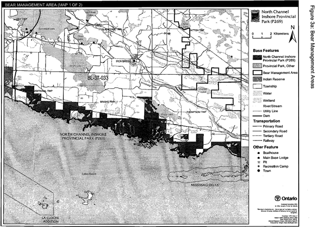
Bear management areas
The park includes portions of two licensed Bear Management Areas (BMAs): BL 37-33 and BL 37-36 (Figure 3a and 3b).
Existing commercial bear hunting operations are permitted to continue. This activity may be subject to conditions identified during future management planning (e.g. the designation of nature reserve zones).
New BMA licences will not be permitted (OMNR 2000; 2003a).
Trapping
There is a portion of an existing active trap line (BL 086) within the park (Figure 4a and 4b). The majority of the park is not included under active harvesting licenses.
Existing commercial fur harvesting operations may continue where the activity has been licensed or permitted since January 1, 1992. New operations, including trap cabins and trails, will not be permitted (OMNR 2000; 2003a).
Transfers of active trap line licenses are permitted, subject to a review of potential impacts and the normal transfer or renewal conditions that apply.
5.1.3 Industrial resources
Aggregate extraction is not permitted in provincial parks unless it is allowed by regulation (OMNR 1992; 2004a; Provincial Parks Act).
The boundary of North Channel Inshore Provincial Park includes two abandoned aggregate pits (OMNR 1992). These pits in Striker Township are no longer licensed and have been closed and left to rehabilitate naturally. The Town of Blind River municipal water line crosses through a portion of one of these abandoned pits.
There are no existing mining claims within the park. The mining and surface rights on all lands within the park have been withdrawn from staking under the Mining Act (1990). Mineral exploration and mining are not permitted in the park.
5.1.4 Access and crossings
North Channel Inshore Provincial Park is accessed by road, non-motorized trails and water.
Access
Highway 17 passes to the north of the park. Many portions of the park are accessible via municipal and secondary roads that branch from. Highway 17 and travel toward Lake Huron. Many of these roads provide access to patent property along the shoreline. A non-motorized trail occurs through a portion of the middle of the park. The waters of Lake Huron allow for access to the shoreline areas of North Channel Inshore Provincial Park.
Figure 3a: Bear Management Areas
Enlarge figure 3a: Bear Management Areas (PDF)
Figure 3b: Bear Management Areas
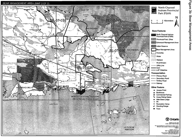
Enlarge 3b: Bear Management Areas (PDF)
Figure 4a: Trap line areas
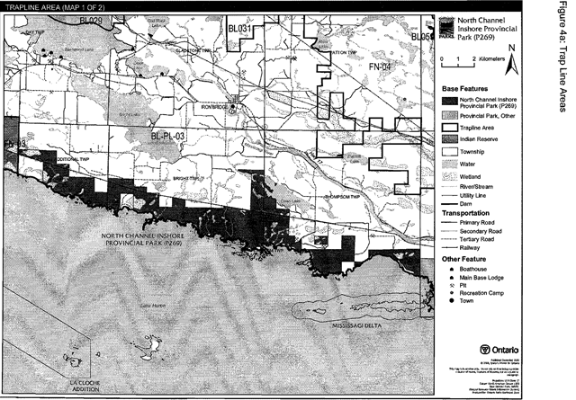
Enlarge figure 4a: Trap line areas (PDF)
Figure 4b: Trap line areas
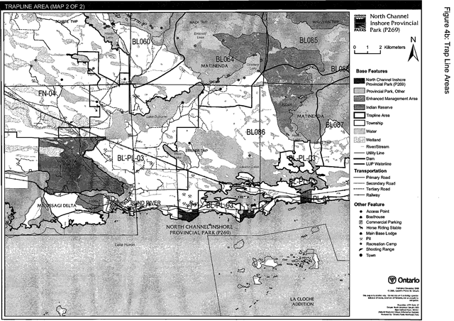
Enlarge figure 4b: Trap line areas (PDF)
Roads
The following lists authorized roads, by township:
Long Township:
Highway 538 travels through the most eastern block of the park, south of the railway corridor (Lot 8, Concession 2). The Highway 538 corridor is excluded from the regulated boundary of this park. This road is maintained by the Ministry of Transportation.
Striker Township:
Little Bog Lake Road travels from Highway 17 toward Lake Huron to private land along the shore. The corridor of this road is included in the regulated park boundary. Ontario Parks is not responsible for the maintenance of this road.
Thompson Township (east to west):
Mississagi Bay Road travels south toward private land located on the shore of Lake Huron. The corridor of this road is excluded from the regulated park boundary. This road is maintained by the Municipality of Huron Shores.
Dean Lake Road travels south to private land on the shore of Lake Huron.This road corridor is excluded from the regulated park boundary. This road is maintained by the Municipality of Huron Shores.
Jerome Road is an old colonization road. The corridor of this road is included in the park. This road travels from Mississagi Bay Road south to an aggregate permit located just outside the park. The Municipality of Huron Shores maintains this road up to the point of entry into the pit. The remainder of this road is not maintained.
Bright Township (east to west):
Eley Road travels between Lots 4 and 5, Concession 3, to private land on Lake Huron. The corridor of this road is excluded from the park. This road is maintained by the Municipality of Huron Shores.
Lake Huron Road (Lots 10, 11, and 12, Concession 4) provides access to private lands on the shoreline. It is not assumed nor is it maintained by the Municipality of Huron Shores. This road is within the park. Ontario Parks is not responsible for the maintenance of this road.
Dayton Station Road is an old colonization road. This road is included in the park. The road is not maintained by the Municipality of hluron Shores. Ontario Parks is not responsible for the maintenance of this road.
Trans Canada Highway 17 runs north of the park and outside the park in Long and Striker townships.
Where existing forest access roads are essential for continued access beyond the park for forest management, recreation or in-holdings (i.e. land use permits, patent land; etc.) and alternative road access does not exist, or road relocation is not feasible, existing roads will continue to be available for access. Continued use will include maintenance and may include upgrading (OMNR 2004a). Ontario Parks is not responsible for maintenance or upgrading of any existing roads within the park boundary.
Any proposed development or maintenance/upgrading of existing roads must meet all Environmental Assessment Act requirements. An external source of aggregate is required for road improvements and maintenance.
Railway
The Canadian Pacific Railway travels through portions of the park in Striker, Thompson, Bright, and Bright Additional townships. The railway corridor (30 metres wide) is excluded from the park boundary.
Utility corridors
There is one utility corridor crossing the park. The Town of Blind River municipal waterline connects Huron Estates and Forrest Glen subdivisions within Striker Township. This utility. corridor will be managed through a LUP issued to the Town of Blind River.
All public utilities (e.g. gas pipelines, transmission lines, communications towers, etc.) must avoid park lands wherever possible, however new utility corridor crossings may be necessary to maintain essential public services (OMNR 2004a).
Any future utility corridors proposed through the park, where park lands are unavoidable, will be reviewed on a case-by-case basis. Protection of park features and values will be a priority and all requirements of the Environmental Assessment Act will be met.
Recreational trails
Snowmobile: The Ontario Federation of Snowmobile Clubs Trans Ontario Provincial System (TOPS) trail “D” travels along utility line corridors, the railway corridor, and along secondary/tertiary roads north of the park. This trail does not cross the park boundary, but is adjacent to the park and follows the northern boundary in Bright Additional, Bright, and Striker townships (Figures 5a and 5b).
All-Terrain Vehicle: There are no authorized all-terrain vehicle (ATV) trails in North Channel Inshore Provincial Park. However, ATV travel which occurs on existing forest management roads will be authorized by the park superintendent.
Hiking: There are two existing authorized trails located within the park.
The Little Lake Bog walking trail, approximately one kilometre in length, is a two way trail that begins in a parking area near Highway 17 and goes to Little Bog Lake in Striker Township. The Town of North Shore has a Memorandum of Understanding to maintain and upgrade this trail.
A multi-use, non-motorized trail (i.e. hiking, walking, and bicycling) links the Forrest Glen and Huron Estates subdivisions in Striker Township. This two kilometres long trail is part of a larger system developed by the Town of Blind River. Trail maintenance will be part of the LUP for the water line that was constructed under a portion of this trail.
New trails (e.g. hiking) may be developed if the need arises. Any proposed development within the park is subject to Environmental Assessment Act requirements.
5.1.5 Adjacent land management
North Channel Inshore Provincial Park occurs across six townships, Bright Additional, Bright, Thompson, Cobden, Striker and Long townships on Lake Huron’s North Channel (Figures 5a and 5b).
New land disposition for the private use of individuals or corporations will not be permitted (OMNR 1992; 2000).
Provincial parks
Mississagi Delta Provincial Park, classified as a nature reserve park, includes 2,395 hectares. This nature reserve complements the North Channel Inshore Provincial Park by contributing to the ecological integrity of the park.
Adjacent tourism developments
Four marinas and dock operations are located on private land adjacent to the North Channel Inshore Provincial Park.
Forestry
The lands adjacent to North Channel Inshore Provincial Park are within the North Shore Forest Management Unit (#680).
General use area
The Crown Land Use Policy Atlas consolidates local land use policies for Crown lands within Ontario’s Living Legacy planning area. Crown lands adjacent to North Channel Inshore Provincial Park are designated as General Use areas that are important for agriculture (G1892), winter deer habitat (G1893), commercial forestry (G1890), commercial/private recreation (G1897), and commercial fishing (G1896/G1987).
5.1.6 Land disposition
Existing LUPs including the two areas that are being processed to address existing infrastructure on Crown land will continue.
New land disposition for the private use of individuals or corporations will not be permitted (OMNR 1992; 2000).
Land use permits, licenses of occupation, unauthorized occupations
There will be four land use permits (LUP) within the park (Figures 2a and 2b).
One LUP is located on Little Bog Lake for a private garage/ workshop in Striker Township.
The Municipality of Huron Shores and Mississagi First Nation manage one LUP for the purpose of a parking lot and access point. This LUP is located on land adjacent to the park boundary in Thompson Township (Part 15 of Regulation Plan).
Two areas of existing infrastructure in Striker Township, a commercial boat dock
Existing authorized LUPs may be eligible for enhanced tenure but not the purchase of land. Recreational camp LUPs cannot be changed to commercial LUPs unless this is supported during a review as part of park management planning.
Enhanced tenure, is defined as a possible extension of the term of the LUP for recreation camps up to 10 years or upgrade in tenure (i.e. LUP to lease) (OMNR 2000a).
Enhanced tenure for an LUP is not guaranteed. Requests for enhanced tenure, or transfers, will be reviewed based upon the following criteria:
- Continued compliance with the conditions of the LUP
- Current land disposition policies for LUPs
- Consistency with park objectives to sustain values- no effects on heritage values and/or conflict with other uses
- Consistency with Aboriginal land claim negotiations or protocol agreements provided all rents, taxes, fees, rates or charges are paid and in good standing.
An extension in the term of tenure for an existing LUP does not convey a commitment to provide for a change in the type or the standard of existing access.
There is a license of occupation (#CL2419) for Beharriel Municipal Park located near the end of Dean Lake Road in Thompson Township (Part 9 of Regulation Plan).
There are two documented unauthorized occupations located within the boundary of the park. These unauthorized occupations are in Bright Township along the shoreline of the North Channel. These unauthorized occupations are cabins which may be reviewed for removal.
Patent land
The waterway park boundary follows and in some cases surrounds adjacent private land.
Private land is not included within the park boundary and as such park policy does not apply to private land.
Waste disposal site
There are no authorized waste disposal sites in North Channel Inshore Provincial Park or on the adjacent lands. No new waste disposal sites will be established.
Boat caches
There are no authorized boat caches located within the boundaries of North Channel Inshore Provincial Park.
Boats are not permitted to be left unattended in the park without written permission from the park superintendent under the authority of the Provincial Parks Act.
5.2 Aquatic ecosystems
Sustaining quality water resources is integral to the protection of park and adjacent lands values. The MOE enforces applicable legislation and regulations for water quality.
5.2.1 Water management
There are no water control structures, hydro electric development or diversion structures within the park.
New commercial hydroelectric developments will not be permitted in North Channel Inshore Provincial Park (OMNR 2000).
5.2.2 Fisheries management
Fisheries management will complement the maintenance and enhancement of native, selfsustaining fish populations.
Sport fishing
Sport fishing is permitted within the park. This activity is governed by legislation and regulations in the Fish and Wildlife Conservation Act and the Fisheries Act (1985). The Recreational Fishing Regulations Summary contains details on the regulations that are applicable to this area.
Commercial fishing
There are no existing commercial fishing operations on waters within the boundary of North Channel Inshore Provincial Park. New operations will not be permitted (OMNR 2004a). Commercial fishing occurs on the waters of Lake Huron, adjacent to this park.
Commercial Baitfish Harvesting. There are portions of six baitfish harvesting license areas within the park: Long (SM0225), Bright Additional (SM0221), Bright (SM0223), and Striker (SM0227) townships. Baitfish licences in Thompson Township (SM0235, SM0242) are not allocated for this use at present (Figure Sa and 5b).
Existing commercial baitfish harvesting may continue where the activity has been licensed or permitted since January 1, 1992.
This activity may be subject to conditions identified through future park management planning or fisheries management plans. New :baitfish licenses will not be permitted (OMNR 2000; 2003).
Fish stocking
The stocking of native fish species may be considered through park management planning, with full public and Aboriginal consultation.
6.0 Operations policies
6.1 Recreation management
Future planning, with full public and Aboriginal consultation, will review direction on recreation uses in the park.
6.1.1 Motorized recreation
There are no waters wholly contained within the park boundary that would support recreational motor boat use or aircraft landings.
Snowmobiles
The Ontario Federation of Snowmobile Clubs (OFSC) Trans Ontario Provincial Series (TOPS) trail “D” travels to the north of the park. A small section of this authorized snowmobile trail is adjacent to the park and follows the northern park boundary in Bright Township.
Snowmobile use on existing routes for access to private land in-holdings, LUPs, and recreational ice fishing may continue unless park values are threatened.
Proposals for new trails may only be considered through future planning with public and Aboriginal consultation (OMNR 2000). Development of trails must meet all Environmental Assessment Act requirements.
All-Terrain vehicles
There are no authorized public all-terrain vehicle (ATV) trails within the park.
The use of ATVs on existing routes for access to private land in-holdings and LUPs is permitted to continue unless park values are threatened. Proposals for new trails may only be considered through future planning with public and Aboriginal consultation (OMNR 2000).
Off-road/off-trail use of all terrain vehicles will not be permitted within park boundaries unless authorized by the superintendent under the authority of the Provincial Parks Act.
Figure 5a: Commercial baitfish areas
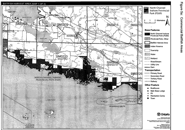
Enlarge figure 5a: Commercial baitfish areas (PDF)
Figure 5b: Commercial baitfish areas
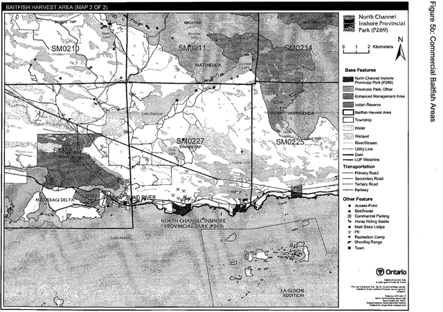
Enlarge figure 5b: Commercial baitfish areas (PDF)
6.1.2 Non-motorized recreation
Camping
There are currently no developed campsites within North Channel Inshore Provincial Park. There are unmanaged dispersed backcountry campsites located within the park boundary which are associated with persons boating on Lake Huron. Existing dispersed backcountry camping use may continue, unless park values are threatened (OMNR 2004a).
Ontario Parks may assess the condition of existing campsites and will maintain, rehabilitate, or close sites as required. If there is an identifiedneed, new campsites may be considered (OMNR 2004a). Infrastructure will be permitted in order to protect park features and values in response to use, environmental deterioration and environmental protection requirements. Any proposed development in the park must fulfill the requirements of the Environmental Assessment Act.
Hiking
There are two authorized existing trails located within the regulated boundary of this park. These trails offer short distance walks and are not part of a larger trail system within the park boundary.
Existing unauthorized hiking trails and other non-mechanized trails are permitted to continue. The park superintendent may discontinue existing unauthorized trails if it is determined that such trails threaten park features and values, create user conflicts or raise safety issues.
If there is an identified need, the development of new hiking trails may be considered. Trail infrastructure to protect park values and features will be permitted. Any proposed development within the park is subject to Environmental Assessment Act requirements.
Canoeing/Kayaking
Existing uses may continue, unless park values are threatened (OMNR 2004a). Infrastructure to protect park features and values may be permitted and developed in response to use, environmental deterioration and environmental protection requirements.
6.1.3 Emerging recreational uses
There are emerging recreational uses for which there is limited or no policy to deal with their management (e.g. adventure racing, geocaching). The park superintendent will use legislation, policy and guidelines that are in place to manage emerging uses.
6.2 Development
The two authorized hiking trails are the only development within the park.
Infrastructure to protect park features and values may be permitted and developed in response to use, environmental deterioration, and environmental protection requirements. Any proposed development within the park is subject to the Environmental Assessment Act.
6.3 Commercial tourism
Commercial tourism development exists on adjacent private land but is not within the park. New commercial tourism facilities may be considered where they would be consistent with park policy (OMNR 2004a). Any development must meet the requirements of the Environmental Assessment Act.
7.0 Cultural resources
An assessment of the cultural resources specific to North Channel Inshore Provincial Park has not been conducted. The management of cultural values within the park will be directed toward protection and heritage appreciation (OMNR 1992).
8.0 Heritage education
Literature and other supporting information may be developed to describe the park in the context of Ontario’s provincial park system. Boundary limits, significant heritage features and permitted uses of the waterway park may be included in park literature.
Prospective park visitors may be informed about the sensitivity and significance of park values through park literature.
9.0 Research
Scientific research by qualified individuals which contributes to the knowledge of natural or cultural history, or to environmental or recreational management, may be encouraged in the park. Ontario Parks will encourage institutions, such as universities, to undertake research projects.
All research programs will require the approval of Ontario Parks and are subject to park policy and other applicable legislation. Any materials removed from the park will remain the property of Ontario Parks.
Approved research activities and facilities will be compatible with the park’s protection objective. Any site which is affected by research will be rehabilitated as closely as possible to its original state. Environmental Assessment Act requirements will apply.
10.0 References
Bergsma, B. 1998a. Area of Natural and Scientific Interest Life Science Checksheet- Dayton Beach Ridge and Swale.
Bergsma, B. 1998b. Area of Natural and Scientific Interest Life Science Checksheet- Foul Bight Ridge and Swale.
Bergsma, B. 1998c. Area of Natural and Scientific Interest Life Science Checksheet- Bright Point Wetlands.
Bergsma, B. 1998d. Area of Natural and Scientific Interest Life Science Checksheet- Siccorde Point Islet Marsh.
Bergsma, B. 1998e. Area of Natural and Scientific Interest Life Science Checksheet- Mississagi Bay Shoreline Marsh.
Environmental Assessment Act, 1990.
Fish and Wildlife Conservation Act, 1997.
Fisheries Act, 1985.
Frey, E. and D. Duba., 2003. P269 North Channel Inshore Waterway Provincial Park. (Draft Earth Science Checksheet)
Kutas, B., 2005. North Channel Inshore Waterway Provincial Park (P269) Recreation Inventory Report- Version 1.1.
Migratory Birds Conservation Act, 1994.
Mining Act, 1990.
Morris, E.R., 2003. Natural Heritage Area Life Science Checksheet- North Channel Inshore Provincial Park.
Ontario Ministry of Natural Resources, 1974. A Topical Organization of Ontario History. Historic Sites Branch Division of Parks.
Ontario Ministry of Natural Resources, 1992. Ontario Provincial Parks Planning and Management Policies.
Ontario Ministry of Natural Resources, 1999. Ontario’s Living Legacy Land Use Strategy.
Ontario Ministry of Natural Resources. 2000.Ontario’s Living Legacy Land Use Strategy (Policy Clarification) September 26, 2000.
Ontario Ministry of Natural Resources, 2002. Public and Aboriginal Consultation Documentation Form Ontario’s Living Legacy Protected Area Boundary Refinement Review.
Ontario Ministry of Natural Resources, 2003. Directions for Commercial Resource Use Activities in Provincial Parks and Conservation Reserves. 5 pp.
Ontario Ministry of Natural Resources, 2004a. Crown Land Use Policy Atlas.
Ontario Ministry of Natural Resources, 2004b. Forest Fire Management Strategy for Ontario. Aviation and Fire Management Branch.
Ontario Ministry of Natural Resources. 2005a. A Class Environmental Assessment for Provincial Parks and Conservation Reserves.
Ontario Ministry of Natural Resources. 2005b. List of Forest Management Units and Forest Management Plan Renewal Schedule 2005. Provincial Parks Act, 1990.
Appendix A: Background information
- Name: North Channel Inshore Provincial Park (P269)
- Classification: Waterway
- Ecoregion/Ecodistrict: 5E-1 (Thessalon)
- OMNR Administrative Region/District: Northeast-Sault Ste. Marie
- Regulation date and Number: November 22, 2002 (O. Reg. 311/02)
Representation
Earth science: The western Abitibi Subprovince, in the Archean Superior Province of the Precambrian shield underlies the majority of North Channel Inshore Provincial Park. Four small areas are within the western part of the Paleoproterozoic 2.4 to 2.2 billion years old Huronian Supergroup of the Southern Province.
The surficial deposits of the park are thin sandy ground moraine till and larger areas of glaciolacustrine sand, silt, and clay. The till remains in bedrock pockets, deposited approximately 15,000 years ago by the south-south-westward advancing Superior Lobe of the Late Wisconsinan continental ice sheet. Glacial lake action exposed extensive bedrock areas adjacent to the Lake Huron shoreline and the tops of interior outcrops. This also resulted in several areas of numerous stranded beach ridges.
Within the Ontario Provincial Parks system the bedrock geology of this park is locally significant. The surficial geology of North Channel Inshore Provincial Park is regionally significant in its representation of numerous pre-Lake Huron shoreline beach ridges.
Life science: This provincial park encompasses the largest undeveloped section of the North Channel of Lake Huron shoreline in Ecodistrict SE-1 (Morris 2003).
Through a gap analysis of Ecodistrict SE-1 using, Forest Resource Inventory (FRI) data and Northern Ontario Engineering Geology Terrain Study data, Morris (2003) determined that there are twelve forest and four non-forest ecosite types within this provincial park. North Channel Inshore Provincial Park is considered to have life science features of provincial significance.
North Channel Inshore Provincial Park encompasses several areas that were identified as candidate life science Areas of Natural and Scientific Interest (ANSI).
North Channel Inshore Provincial Park supports interior forest habitat, which is now uncommon on the North Channel coast in Ecodistrict SE-1 (Morris 2003). This habitat provides excellent breeding habitat for edge sensitive or area-sensitive migratory bird species and some small mammal species (Morris 2003). This area is an important waterfowl staging and nursery area (Morris 2003).
Cultural resources: There has been no examination of the cultural resources of the North Channel Inshore Provincial Park.
Recreation and tourism: The North Shore of Lake Huron is an area of exceptional recreation opportunities. Hunting, angling, birding, canoeing, camping, boating, sailing, sea kayaking, and nature appreciation are among the variety of recreational activities that are common in this area.
Large game animals such as deer, moose, and black bear are common animals that draw hunters to this area. Small game and birds, such as rabbits, waterfowl, and grouse, also draw hunters to this area. The waters of Lake Huron and the numerous smaller lakes offer some of the best sport fishing opportunities in Northern Ontario.
The North Channel of Lake Huron is world renowned for its boating opportunities. Sailing and power boating are common recreational activities of the North Channel. Canoeing and sea kayaking are also becoming popular in this area. The waters of the North Channel are relatively sheltered from winds from the south due to the numerous islands located to its south, the largest being Manitoulin Island.
Inventories
- Survey level: Reconnaissance
- Earth science: Frey and Duba, 2003
- Life science: Morrise, 2003
- Cultural: Kutas 2005
- Recreational: N/A
Footnotes
- footnote[1] Back to paragraph The locations of these naturally significant areas are included in the Natural Heritage Area Life Science Checksheet completed by Morris (2003)
- footnote[2] Back to paragraph Transfers include situations where a license is surrendered with a request that it be immediately reissued to another individual or organization that is assuming an existing operation. Trap cabins are considered part of a trapline and would be transferred with the trapline for the purposes of trapping. If a trapline license is revoked or surrendered, all portions of the registered line within the park will be rescinded from the legal description of the trap line (OMNR 2003).
- footnote[3] Back to paragraph A commercial fish cleaning station associated with commercial fishing license BL8403 is within the park in Striker Township; (Federal Fisheries Act) for operations on Lake Huron. This use is documented, and will be delineated in a permit and will be given approval by the park superintendent.