Rideau River Provincial Park Management Plan
This document provides policy direction for the protection, development and management of Rideau River Provincial Park and its resources.
Approval statement
1985/03
We are pleased to approve the Rideau River Provincial Park Management Plan as official policy for the management and development of this park. The plan reflects the ministry’s intent to protect the natural features of Rideau River and maintain high quality opportunities for outdoor recreation in an attractive setting for residents of Ontario and visitors to the province.
J.R. Oatway
Regional Director
Eastern Region
Norm R. Richards
Director,
Parks and Recreational Areas Branch
1.0 Introduction
In 1957 it was announced that a swimming beach and camping facilities would be developed along the Rideau River on forest station land north of Kemptville. Rideau River Provincial Park was opened in 1959 by the Honourable J. W. Spooner, then Ontario Minister of Lands and Forests. Order in Council designation as a Provincial Campground came in 1963. It was a very well developed park and high use levels reflected its popularity.
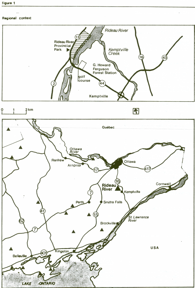
As more recreational facilities became available use patterns shifted and Rideau River became less popular. Recent trends indicate a rediscovery of the values which made this park popular originally. Valued for its convenient location, 40 km from its major market of visitors and residents in Ottawa, its opportunity for quiet relaxation in. an attractive environment as well as its setting on the Rideau Canal close to historic towns and features, the park bas had a moderate increase in use between 1981 and 1983. See Figure 1.
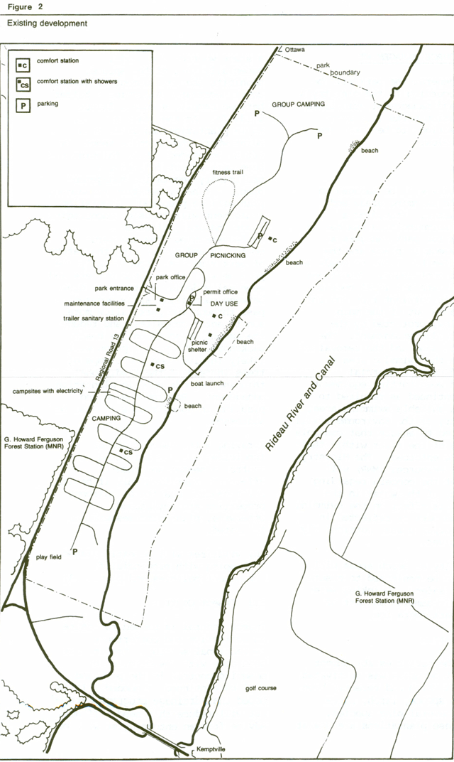
The park is 98 ha in area including part of the Rideau River. Coniferous plantations started in the 1940’s form the dominant vegetation, with some contrasting wetland vegetation harbouring waterfowl and other wildlife along the two small creeks and undeveloped parts of the river shoreline. It offers 184 campsites as well as 4 group campsites each capable of supporting 75 to 125 people.
Showers and 31 electrical sites are among the campground amenities. There are four sand beaches: one at the campground; another at the group camps; and one serving each of the two separate day use areas. See Figure 2. Since 1984 the daily operation and maintenance of Rideau River Provincial Park has been done through a contract agreement with a private operator.
The park has little natural or historical significance beyond its recent recreational use. Vegetation patterns are the only cultural features remaining.
1.1 Issues
The issues affecting Rideau River Provincial Park are resource related, such as management of coniferous plantations to provide a stable, aesthetically pleasing recreation site; and dealing with aquatic weed and algae growth. These are addressed in the resource management section. Several issues related to traffic circulation and the effects of the proximity of Regional Road 13 are discussed in the development section.
2.0 Park policies
2.1 Classification
“Recreation Parks are areas which support a wide variety of outdoor recreation opportunities for large numbers of people in attractive surroundings.”[12] Rideau River Provincial Park is classified as a recreation park emphasizing its value as a convenient campground, picnic spot and water access point along the Rideau Canal.
2.2 Goal
- To provide opportunities for camping, swimming and day use activities and to serve as a base for exploring the historic Rideau canal and visiting the National Capital.
Rideau River Provincial Park contributes mainly to the achievement of the recreation and tourism objectives.
2.3 Objectives[11]
2.3.1 Recreation
- To provide provincial park day use and facility-based camping opportunities in an attractive setting.
Rideau River Provincial Park annually provides recreational opportunities as follows [4] (Shown in brackets is % of Carleton Place District supply).
- Swimming: 24,454 (37%)
- Picnicking: 89,827 (52%)
- Camping: 47,138 (23%)
2.3.2 Tourism
- To provide Ontario residents and visitors from outside the province opportunities to discover and experience the distinctive regions of the province.
Many of the visitors drawn to Canada’s capital and boaters using the Rideau canal need camping facilities during their stay. Only 40 km from Ottawa, Rideau River Provincial Park is located near Provincial Highway 16, one of the major access routes to the city. The park is also situated along the Rideau Canal near canal structures, Parks Canada and Conservation Authority interpretive sites, and the historic towns of Burritts Rapids, Kemptville, Merrickville and Manotick.
2.4 Zoning
Sandy soil and flat terrain combine to make the park site capable of supporting intensive use. Most of the park’s vegetation is coniferous forest plantation established in 1947. Existing campgrounds, picnic areas and beaches occupy most of the park area. This is reflected in the designation of the entire park as development zone.
Within the park are small wetlands and an area in the northeast part of the park with natural vegetation succession. Management of these swimming picnicking camping areas will aim to foster these natural qualities and this principle will be extended to the whole park wherever possible. For example, the plantations will be managed to allow natural regeneration to occur. The park will continue to be managed according to provincial park policies for development zones in recreation class parks[11] and to maintain a high level of aesthetic appeal.
In 1983 over 43,000 people visited the park, an increase from the 35,000 visitors in 1981. There has been a similar increase in July/August occupancy from 35% in 1981 to 47% in 1983. [13] This figure is still below park capacity and no additional camping facilities are planned.
3.0 Resource management
While in general the park will be managed according to the ministry’s planning and management guidelines for recreation parks [11] some specific actions to be taken are outlined below.
3.1 water
Water quality will be managed to ensure safe swimming areas and drinking water. Providing a weed-free swimming area has been a major task for park managers at Rideau. Weeds in place are the major problem but floating weeds and algae also contribute. Conditions for weed growth are ideal because the water is nutrient rich and the beach area is out of the main channel flow, protected by the upstream bridge embankment. The addition of sand and the removal of weeds from the swimming area by raking and using commercial mechanized weed cutting equipment will be continued as required to maintain a suitable swimming area.
The Ministry of the Environment will be contacted to ensure that controls on the use of the river within their mandate are enforced. The Ministry of Natural Resources (MNR) will ensure that the concern regarding the quality of the water in the river and its effect on the swimming area at the park is reflected in local municipal plans, particularly those up river.
Water quality at beach areas will continue to be monitored to ensure health and safety. Drinking water is regularly sampled as part of standard park operation.
3.2 Vegetation
Prior to the park’s establishment the land it occupies was cultivated farm fields which had recently been planted to spruce, larch, silver maple and several pine species.Some of these plantations are now at a stage whereby the shade, especially that of the spruce, prohibits the development of ground cover necessary to provide a buffer between campsites and to favour wildlife. At the beach a silver maple plantation has grown to a point where the beach backshore is often too shaded. Some thinning has been carried out following a preliminary vegetation management plan. A final vegetation management plan will be prepared. Vegetation management will focus on encouraging a more natural, mixed and self-sustaining tree and shrub community and on ensuring the safety of park visitors. Specifically the program will allow shrub buffers and eventually deciduous trees to grow between campsites; allow breezes to pass through the park; allow more sun to enter campsites; and reduce the amount of shade on the beach backshore. The prescription will likely involve removing clumps of trees instead of the traditional thinning methods used in plantation management. Routine mowing and planting in open areas will also be addressed.
Spraying with insecticides or fungicides will be initiated to control diseases and insects affecting vegetation only if health, environmental quality or adjacent properties are threatened. Otherwise, plant diseases will be tolerated.
Any wildfires will be extinguished in keeping with provincial fire management policies and plans. [3]
3.3 Insect control
Insect control is needed to ensure an attractive and comfortable recreational setting. Fogging has been done with insecticide for mosquito control in the park and will be continued as needed. It is hoped that drainage programs carried out will reduce this need. If not, advice from an entomologist will be sought and further control plans devised. In consideration of retaining possible natural values associated with wetlands further ditching would only be carried out if there is no suitable alternative.
3.4 Fish
Fish management will aim to provide opportunities for fishing recreation consistent with a healthy Rideau River fish community. Sport fishing on the Rideau River will be encouraged. Access to fishing will be improved at the park through the provision of docks and other facilities and services as demand warrants.
3.5 Wildlife
Wildlife management will be directed to retain beaver, muskrat and other shoreline species habitat and to enhance viewing opportunities in keeping with the recreational environment of the park. Hunting and trapping are not permitted in the park. Control of nuisance species will be allowed when necessary following a wildlife management plan to be prepared and approved by the Regional Director. Activities such as bank tunneling and tree cutting by beaver and muskrat in particular will be tolerated where they do not pose a safety hazard or conflict with users' enjoyment of the park. These species probably represent the best wildlife viewing opportunity during the summer season, though deer are occasionally seen in the fall and winter.
4.0 Client services
4.1 Visitor services
Visitor services will focus on providing information and facilities for park visitors. Communications will inform park visitors about the provincial park system and Rideau’s role in it. It will orient visitors to park facilities and services and inform them about facilities and attractions in the area around the park, including the nature trails at the G. Howard Ferguson Forest Station across the river. Special emphasis will be given to promoting the cultural history of both the surrounding area and the Rideau Canal. Visitors will be encouraged to comment on park facilities and services. Park staff, park and other agency publications, and display information will help achieve these visitor services objectives.
There are limited opportunities for interpreting park resources. Minor themes, such as forest regeneration and management, wetland ecology and water quality control will be interpreted through self-use facilities prepared by district staff. Where possible, special events organized at the park will focus on these themes as well.
The park will continue to welcome input by Parks Canada staff in interpreting the historic Rideau Canal and will assist in this effort by orienting park visitors to Parks Canada interpretive facilities. Co-operative arrangements will be investigated with Parks Canada to enhance visitor services programming at the park.
Self-use recreation facilities already provided include a fitness trail, swimming facilities and an informal playfield. Creative playgrounds will be provided to supplement existing equipment. A shoreline walking trail will also be developed. Programs sponsored by other agencies which help visitors gain knowledge and skills in recreational pursuits at the park will also be welcomed. The park facilities will be available to school and other organized groups for camping and day use.
Visitor services plans have been prepared for the park and the eastern region, providing further direction to visitor service efforts consistent with this management plan.[5]
4.2 Marketing
A marketing plan[6] has been developed primarily to increase park use. The park will be pranoted in the Ottawa region as a nearby location for camping and exploring the historic Rideau Canal and to visitors from further away as a suitable base from which to visit the National Capital. Emphasis will also be given to the fact that there is usually camping or picnic space available at Rideau River Provincial Park when other parks are full. Group camping and picnicking will also be promoted.
4.3 Concessions
Camping supplies, canoe rentals and fast-food outlets are available near the park so there is no need to provide these services within the park. However, concessions selling firewood, renting paddleboats and providing other services may be established at the park.
4.4 Emergency services
A park emergency plan will be prepared to provide park staff with instructions for emergency situations, such as fire and injury. This plan will be reviewed yearly and updated as required.
Hospital services are available in Kemptville.
5.0 Proposed development
In keeping with the goal to provide opportunities for camping, swimming and day use activities and to serve as a base for exploring the Rideau Canal and the National Capital, the following developments are proposed.
Development will proceed in accordance with Figure 3 and the following guidelines. In all instances appropriate site plans will be completed and approved in advance of new development or the upgrading of existing facilities.
5.1 Camping
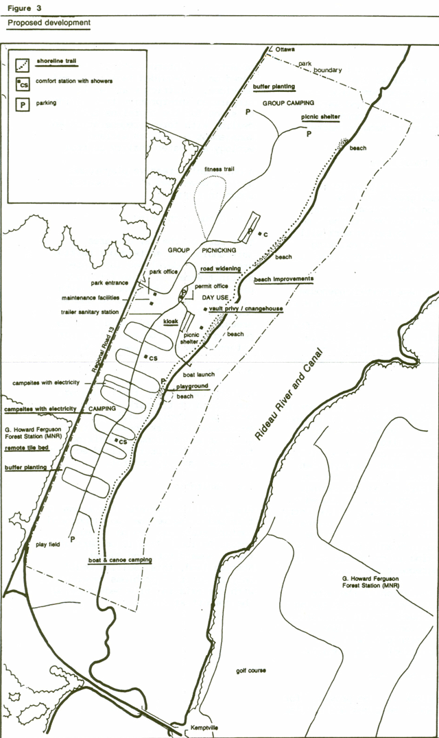
More shrubs, vines and trees will be planted along the park boundary to further buffer campsites from Regional Road 13.
Campsites with electricity are among the most popular in the park.
Electrical service will be provided to an additional 30 sites near the road. These sites suit trailer campers as they are less affected by traffic noise.
Improvements will be made to the boat-in camping area at the west end of the park to provide campsites for canoeists and boaters using the canal. Levelling and the provision of picnic tables is the first step. Docks and other facilities may be developed as demand warrants.
5.2 Group camping
Four group camp areas will continue to be provided at the east end of the park. The campsite nearest the river may be moved slightly eastward into a presently wooded area behind a stand of large willows and promoted as a group canoe campsite.
Another group camp improvement will be the development of the backshore area behind the group camp beach as an open field for groups from all sites to use. Cooking shelters will be provided to further facilitate group use. Planting will be undertaken to buffer the northernmost campground from the highway. Facilities and services in this area will be improved as required to suit changing market demands.
5.3 Beach facilities
At the main beach a plastic base to control weed growth will be installed on the bottom and sand added, especially beyond the 1 m water depth. Upgrading work will be continued to repair an existing retaining wall and improve turf in the dry beach area.
The existing washroom\changehouse serving the main day use beach will be monitored yearly for structural damage caused by foundation shifts. A building to house vault privies and change houses is planned to replace this 25 year old structure.
5.4 Traffic
The park office near the entrance is no longer used for permit sales and its presence is to some extent, confusing to visitors.
Self-registration camping permits are dispensed nearby on days when the entry control located further within the park is not operating. Appropriate signs will be placed to guide visitors directly to the entry control. If signs do not eliminate the confusion to visitors at the park office, new solutions will be found, working in co-operation with contract agreement operator.
Traffic circulation at the entry control also requires modification to reduce congestion and to improve safety conditions at peak use periods. A site plan will be prepared to direct these changes.
5.5 Visitor services
A display kiosk will be provided for park management messages and tourism promotion. Interpretation will be based on self-guided facilities and services. District staff will prepare an interpretive trail guide or signs for the shoreline trail dealing with forest regeneration and management as well as wetland ecology and water quality control.
A children’s creative playground will be developed at the location shown in Figure 3.
5.6 Group picnicking
That part of the day use area surrounding the easternmost parking area will be developed into three distinct areas suitable for group picnics. Additional shelters with fireplaces will be provided and will serve as focal points for these areas. An open play field near the parking lot will be maintained for informal use by day use groups.
5.7 Trails
A shoreline walking trail running the length of the park will be developed. Cycling will be encouraged on park roads. A trail guide or signs along the walking trail will interpret wetland ecology and water quality control.
5.8 Sanitation
Plans will be completed for a remote tile bed to serve the two campground comfort stations. To be located across Regional Road 13 on part of the G. Howard Ferguson Forest Station land, this facility would only be built if problems develop with the existing tile beds serving the comfort stations.
6.0 Implementation strategy
The following projects will be undertaken with approval of this management plan. They will depend on Ministry of Natural Resources' priorities for capital funding. The management plan will be reviewed as the need arises over its 20 year term.
Phase I
Low cost projects to be undertaken as soon as possible:
- improve wet and dry beaches
- vegetation management plan
- wildlife management plan
- develop creative playground
- develop shoreline trail
- level open area at park’s west end for camping by canoeists and boaters
Phase II
Higher cost projects with potential for generating more park use
- construct vault privy/changehouse to replace main day use area comfort station
- provide docks for sport fishing
- complete canoe group camping area
- electrify 30 more campsites
- interpret forest management and wetland ecology
- improve boat-in campsite area at park’s west end adding docks and other facilities as needed.
Phase III
Projects without revenue benefits
- construct display kiosk
- construct picnic shelters in group camping and picnic areas
- construct remote tile bed, if required
7.0 Public consultation
Comment on the park’s future management was invited during the management planning process. News releases were sent to local radio stations and newspapers inviting the public to review and comment on the 1984 preliminary management plan. A display was set up at the park to solicit comment from park visitors. Local governments were sent copies of the plan for their review.
There was minimal response to the preliminary plan and no major concerns were raised. Incorporating some minor changes and updating this approved management plan confirms the park policies set out in the 1984 preliminary management plan. It will guide the management of Rideau River Provincial Park for the next 20 years.
Bibliography
- Cuddy, D.G. Life Science Inventory Check-sheet, Rideau River Provincial Park. Unpublished draft. Kemptville: Ontario Ministry of Natural Resources, 1979.
- Fraser, James A. Rideau River Provincial Park: A Centre for Discovery. Unpublished report. Kemptville: Ontario Ministry of Natural Resources, 1983.
- Ontario Ministry of Natural Resources. Aviation and Fire Management Policy #AF.03.01.01. Sault Ste. Marie: Aviation and Fire Management Centre. 1983.
- Ontario Ministry of Natural Resources. Carleton Place District Land Use Guidelines. Carleton Place, 1983.
- Ontario Ministry of Natural Resources. Eastern Region Provincial Parks Visitor Services Plan, draft. Unpaged, unpublished report. Kemptville: Parks Branch. 1984.
- Ontario Ministry of Natural Resources. Marketing Strategy for Rideau River Provincial Park. Unpublished report. Carleton Place District, 1984.
- Ontario Ministry of Natural Resources.1983 Provincial Park camper Survey Summary Statistical Report. Toronto: Parks and Recreational Areas Branch, 1983.
- Ontario Ministry of Natural Resources. 1983 Provincial Park Day User Survey Summary Statistical Report. Toronto: Parks and Recreational Areas Branch, 1983.
- Ontario Ministry of Natural Resources. 1977 Provincial Park Camper Survey Summary Statistical Report. Toronto: Provincial Parks Branch, 1978.
- Ontario Ministry of Natural Resources. 1977 Provincial Park Day User Survey Summary Statistical Report. Toronto: Provincial Parks Branch, 1978.
- Ontario Ministry of Natural Resources. Ontario Provincial Parks Planning and Management Policies. Toronto: Park Planning Section, 1978.
- Ontario Ministry of Natural Resources. Ontario Provincial Parks Policy. Publication Number 5739. Toronto: Provincial Parks Branch, 1978.
- Ontario Ministry of Natural Resources. Ontario Provincial Parks Statistics 1983. Toronto: Parks and Recreational Areas Branch, 1984.
- Ontario Ministry of Treasury, Economics and Intergovernmental Affairs. Ontario Population Projections to 2001. Toronto, 1974.
- Pratt, Bill. Habitat and Wildlife Survey of Rideau River Provincial Park, 1979. Unpublished report. Kemptville: Ontario Ministry of Natural Resources, 1979.
- Regional Municipality of Ottawa-Carleton, Regional Planning Department. Official Plan Schedule “A”, Rural Policy Plan. Ottawa, 1980.
- Tourism and Outdoor Recreation Planning Study Committee. Tourism and Recreational Behaviour of Ontario Residents, Volumes 1 to 8. Toronto: Queen’s Park, 1977.
- Woerns, Norbert. Earth Science Inventory Checklist, Rideau River Provincial Park. Toronto: Ontario Ministry of Natural Resources, 1977.