Seahorse Lake Conservation Reserve Management Statement
This document provides policy direction for the protection, development and management of the Seahorse Lake Conservation Reserve and its resources.
Approval page
Statement of Conservation Interest for Seahorse Lake Conservation Reserve C2232
Nipigon District
Northwest Region
The purpose of this Statement of Conservation Interest is to identify natural heritage values of the Conservation Reserve and the activities which occur at this location. This Statement outlines the activities which will be permitted and those which will be prohibited. From this outline, the management direction for the location can be determined.
Approved:
Ian Hagman, District Manager, Nipigon
Date: March 27, 2001
Charlie Lauer, Regional Director, Northwest
Date: April 4, 2001
1. Examination and adjustment history of management direction
| Approval Date | Examination or Type of Adjustment | Examination Outcome | List of Supporting Documents |
|---|---|---|---|
| NA |
|
|
e.g., amendment form, administrative update form, secondary plan, examination report, examination confirmation statement |
| March 2, 2012 | Examination | Administrative Update |
|
| June 21, 2018 | Examination | Administrative Update |
|
2. Introduction
On July 16, 1999, the Ontario Government released the Ontario’s Living Legacy Land Use Strategy to guide the planning and management of Crown Lands within a large part of northern and central Ontario. A major component of this Land Use Strategy was the statement of intent to establish 378 new protected areas in this part of Ontario. This commitment is to the largest expansion of Provincial Parks and other protected areas in the history of Ontario.
The Seahorse Lake Conservation Reserve (C2232) is one site within this expansion of Ontario’s protected areas.
Conservation Reserves are areas of Crown land set aside by regulation under the Public Lands Act to complement provincial parks in protecting representative natural areas specific landscape features. Most recreational activities (e.g. hiking, skiing, tourism related uses, nature appreciation) and non-industrial commercial activities (e.g. fur harvesting, bait fishing and commercial fishing) bat have traditionally been enjoyed in the area will continue provided that these use do not impact upon the natural features requiring protection. Recreational hunting and fishing are permitted uses.
Commercial timber harvesting, mining, aggregate extraction and hydroelectric development are prohibited in conservation reserves.
The Seahorse Lake Conservation Reserve contains representative landform and vegetation types including conifer and conifer mixed forests and treed wetlands on moderately broken ground moraine. More detail is available in the Earth Science Report (GEC 2000) and Life Science Report (GEC 2001).
Seahorse Lake Conservation Reserve is not readily accessed. Access can be gained to the relative vicinity of the site by way of logging roads.
The purpose of this Statement of Conservation Interest is to identify the natural heritage values of Seahorse Lake Conservation Reserve and the activities which occur at this location. Through a set of management guidelines this statement will outline the activities which will be permitted and those which will be prohibited. From this outline, the management direction for the area can be determined.
Statement of Conservation Interests will be kept updated through periodic examination to determine whether direction is adequate or subject to any necessary changes, for the management of a protected area (OMNR, 2014a). Examinations should address the following:
- whether the existing management direction document is relevant, effective, current, and reflects the reality on the ground, and,
- whether changes are required to the document to enable the management of the protected area until the next scheduled examination
3. Background information
The Seahorse Lake Conservation Reserve is located 30 kilometres northeast of the Town of Nipigon. Seahorse Lake is within the conservation reserve and forms the eastern boundary, and Cull Lake (possibly known as Looie Lake) is the western boundary. The eastern portion of the Conservation Reserve is drained by the Jackpine River watershed and the western portion is drained by the Jackfish River watershed.
Name
Seahorse Lake Conservation Reserve
Ecoregion/Ecodistrict
Nipigon/Schreiber 3W-5
OMNRF Administrative Region/District
Northwest/Nipigon
Total Area (ha)
658 ha
Regulation date
June 23 , 2000
First Nations
Robinson Superior (1850) Treaty Area.
UTM
16 4300 54400
Lat./Long.
49 11′ 00″ / 87 55′ 00″
Basemap
492874 (c. 1975)
Access
The conservation reserve is reatively isolated. Modes of access include: foot, air, or by water from Cosgrove Lake into Cull Lake. Recently, an All-Terrain vehicle trail has been created to Seahorse Lake from decomissioned logging roads.
4. Representation targets
This section provides a summary of the earth and life science system and values and cultural resources represented; and recreational opportunities available or possible.
Life science representation
Regionally significant mature mixedwood and coniferous forest on weakly to moderately broken bedrock overlain by thin and often discontinuous morainal materials. It is representative of upland areas within Ecodistrict 3W-5. Twelve landcover/vegetation associations are present, of which five are critical to ecodistrict representation.
Earth science representation
Representative of weak to moderately broken bedrock with thin and often discontinuous till veneers typical of the Quetico Subprovince of the Superior Structural Province. In addition two easily observable fault lines bisect the area in a north-south direction. The contrasting till material may provide evidence of glacial re-advances across the area. Numerous organics have developed in remnant lake beds.
Cultural resource representation
No documented cultural resources.
Recreational opportunities
Opportunities exist for wildlife viewing and for fishing
5. Survey information
This section provides an overview of the inventories completed. Their level of detail and any further inventories needed.
| Level/type | Earth science | Life science | Cultural | Recreational |
|---|---|---|---|---|
| Reconnaissance completion date | Yes, 2000 | Yes, 2000 | Yes | Yes, 2001 |
| Detailed completion date | No | No | No | No |
| Required? | No further requirement | No further requirement | No further requirement | No further requirement |
| Other | NA | NA | NA | NA |
6. Values to be protected
This section provides a description of the key natural heritage values on the site and their condition relative to past resource use and management activities. It also addresses the sensitivity of these values to future land use and management activities.
The intent of this Statement is to protect those values identified on site by establishing guidelines for existing and potential uses in this area, given the level of past disturbances and the nature of existing features.
Wildlife values –The conservation reserve protects a number of aquatic feeding areas for moose and part of a moose thermal (late winter or summer) cover habitat.
Mature coniferous forest may be of connectivity value to transient forest-dwelling woodland caribou.
Vegetation values – The entire conservation area is protected (including the Old Growth component) from human disturbance. The forest cover on this site is representative of the surrounding area and is predominantly fire origin mature stands.
Landcover / vegetation types critically important to Ecodistrict 3W-5 present within Seahorse Lake Conservation Reserve include: open Marsh/Fen/Bog, black spruce dominated forest, tamarack dominated forest and intolerant hardwood –other conifer mixed forest on organic deposits (19-2, 19-38, 19-39, and 19-47, respectively), and tamarack dominated forest on Precambrian intermediate to acidic bedrock (4-39) (Gap Tool 2014b).
Recreation and tourism values -The site offers few opportunities for recreational use due to the lack of road or water access into the Conservation Reserve. Modes of access to the conservation reserve include: by foot, air, or by water from Cosgrave Lake into Cull Lake.
There are no known tourism uses or facilities.
Cultural Values - No cultural values have been identified.
Traditional outdoor heritage values – There is limited potential due to limited access.
7. Management guidelines
The intent of this Statement of Conservation Interest is to protect the following values by identifying site-specific management policies intended to maintain, or where possible, restore the ecological integrity of the area, while giving consideration to recreational opportunities.
7.1 Land tenure
Seahorse Lake Conservation Reserve consists entirely of Crown Land. The Conservation Reserve has been permanently withdrawn from staking. Disposition, by sale, Crown Lease or Land Use Permit, or land tenures of any type, will not be considered within the conservation reserve boundaries.
7.2 Existing and proposed development
There are no existing facilities within the Conservation Reserve. New development that would disturb the forest or the forest understory vegetation will not be permitted. The area will be managed primarily for public nature appreciation, educational experiences and scientific study. Tourism will not be promoted for this area due to the potential for site degradation.
7.3 Recreational activities
Low intensity, non-structural activities that do not impact the health of the forest ecosystem (e.g. viewing, hiking, hunting, etc.) are permitted. An All-Terrain vehicle trail has been created to Seahorse Lake from the decommissioned logging roads. ATV access and snowmobile usage will be closely monitored for possible damage to the trees and site regeneration component. If site degradation occurs, these activities may have to be excluded from the area. Access by non-mechanized means is the preferred method. Currently, there are no recreational activities that take place on the conservation reserve.
7.4 Commercial activities
The following activities are prohibited in Seahorse Lake Conservation Reserve:
- Commercial timber harvest.
- Generation of electricity
- Prospecting, staking mining claims, developing mineral interests or working mines;
- Extracting aggregate, topsoil or peat;
- Other industrial uses.
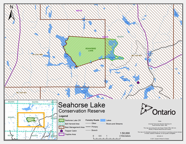
Seahorse Lake Conservation Reserve is located within one trapline (NG-110) and one Bait Fish Harvest Licence Area (NI2505). A small portion of the Conservation Reserve is located within a portion of one Bear Management Area (BMA NG-21A-012). Existing uses are permitted to continue with the condition that no new trails or other development are allowed without specific authorization.
New non-resident guided bear hunting operations are not permitted. New bait fishing and fur harvesting operations will be considered subject to the ‘protected area compatibility test’ . New trap cabins are not permitted.
No new developments will be permitted (i.e. road development, utility corridors and tourism facilities).
7.5 Aboriginal interests
Seahorse Lake Conservation Reserve falls within the area of the Robinson-Superior Treaty of 1850. The conservation reserve is located in the traditional territory of Indigenous people dating back countless generations. The conservation reserve will be managed in a manner consistent with the Constitutional protection afforded existing and future Aboriginal and treaty rights.
7.6 Seahorse Lake Conservation Reserve
Seahorse Lake Conservation Reserve falls within the area of the Robinson-Superior Treaty of 1850. The conservation reserve is located in the traditional territory of Indigenous people dating back countless generations. The conservation reserve will be managed in a manner consistent with the Constitutional protection afforded existing and future Aboriginal and treaty rights. Natural Resources Stewardship.
7.6.1 Vegetation management
The area will be managed in accordance with relevant existing policies. Natural ecosystem processes and features will, for the most part, be allowed to occur with minimal human interference. Forest fire management will be carried out consistent with the Wildland Fire Management Strategy (OMNRF 2014c). According to this strategy, all wildland fires are assessed and receive the most appropriate response aimed at limiting losses from fire damage, maximizing resource and ecological benefits, and lowering costs. Appropriate response considers safety as the highest priority, availability of firefighting resources and managing risk by taking uncertain factors into account (e.g., state of the fire, weather, fire behaviour).
Much of the time, wildland fires will be suppressed because of the potential threat to values (e.g., commercial timber, infrastructure) within and outside the conservation reserve. Some wildland fires will receive a less aggressive response or will be monitored based on a combination of factors including low risk to values, high potential benefits of wildland fire, high anticipated suppression costs and/or hazardous work conditions. Wildland fires being monitored under low risk conditions in conservation reserves provide an opportunity to maintain or enhance ecological integrity.
When a fire is suppressed, “light on the land” techniques will be used whenever feasible (OMNR 2011). These minimal impact suppression techniques do not unduly disturb natural or cultural values. Examples may include limiting the use of heavy equipment or the felling of trees during fire response.
7.6.2 Fish and wildlife management
Fishery and wildlife will continue to be managed in accordance with existing policies and regulations.
Seahorse Lake Conservation Reserve is located within the Discontinuous Distribution for forest-dwelling woodland caribou (OMNR 2009). Ontario will look for opportunities to improve future connectivity between local and isolated caribou populations through land use planning within the discontinuous distribution (OMNR 2009).
Species at risk and their habitat will be protected in a manner consistent with the Endangered Species Act, 2007 and associated regulations. Recovery actions will be implemented as appropriate.
7.6.3 Landforms
Species at risk and their habitat will be protected in a manner consistent with the Endangered Species Act, 2007 and associated regulations. Recovery actions will be implemented as appropriate.
No management requirements except continued protection
7.7 Cultural resources stewardship
No requirements at this time based on existing information. In the event of a discovery of an archaeological site, the Ministry of Natural Resources and Forestry will work with the Ministry of Tourism, culture and Sport to identify and assess the significance of the site. To date there has been no field survey to assess cultural resources and the potential for archaeological finds is unknown.
7.8 Client services
Nipigon District’s Resource Operations Team will be the primary contact for responding to inquiries about the basic level of information such as access, nature appreciation, scientific study requests, wildlife viewing opportunities, hunting, permitted uses and boundaries. Information about Seahorse Lake Conservation Reserve should be made available. Ensure that all resource users especially forestry, mining and tourist companies, are aware of its location and permitted use.
7.9 Research
Non-destructive scientific research by qualified/recognized Canadian institutions or organizations that will contribute to the Ministry of Natural Resources and Forestry natural heritage information base will be encouraged. All research programs will require the approval of the Ministry of Natural Resources and Forestry and will be subject to ministry policy and other relevant legislation.
7.10 Marketing
No requirements at this time
8. Implementation
Implementation of this Statement of Conservation Interest will primarily involve monitoring activities to ensure adherence to management guidelines. The conservation reserve will be managed under the supervision of the Resource Operations Team and Resource Management Team supervisors. Any affected clients will be immediately notified of any amendments to this Statement of Conservation Interest.
Seahorse Lake Conservation Reserve will be managed in accordance with the Provincial Parks and Conservation Reserves Act, 2006.
9. Review and revisions
This Statement of Conservation Interest will be examined in accordance with the provisions of the Provincial Parks and Conservation Reserves Act (PPCRA), 2006 to determine whether the management direction is still relevant, effective and current, or if an adjustment is required.
Where an adjustment is needed, changes will be evaluated for their significance. Changes, which do not alter the overall protection objectives, may be considered and approved by the District Manager through an administrative update without further public consultation. Amendments to the management direction will require full public consultation and the approval of the Regional Director. The need for a more detailed planning process and associated consultation will be considered where a major amendment is needed.
10. Public consultation
Consultation about the establishment and regulation of Seahorse Lake Conservation Reserve occurred from 1997 to 2000. In the event that a more comprehensive planning process takes place to renew or alter the management direction for this conservation reserve, there will be further opportunities for consultation.
11. Sources of Information
Barker, D. 2001. OLL Recreational Inventory for Seahorse Lake Conservation Reserve. 6 pp.
[GEC] Geowest Environmental Consultants. 2001. Earth Science Inventory Checklist for Seahorse Lake (C2232). 8 pp.
[GEC] Geowest Environmental Consultants. 2000. Natural Heritage Area – Life Science Checksheet for Seahorse Lake Conservation Reserve (C2232). 11 pp.
[OMNR] Ontario Ministry of Natural Resources, Ontario’s Living Legacy Land Use Strategy, Queen’s Printer for Ontario, Ontario, Canada, 1999
[OMNR] Ontario Ministry of Natural Resources. 2014. Forest Fire Management Strategy for Ontario. Queen’s Printer for Ontario, Toronto.
[OMNR] Ontario Ministry of Natural Resources. 2009. Ontario’s Woodland Caribou Conservation Plan. Queen’s Printer for Ontario. Toronto, Ontario, Canada. 24 pp.
[OMNR] Ontario Ministry of Natural Resources. 2014a. Ontario Protected Areas Planning Manual. Peterborough. Queen’s Printer for Ontario.
[OMNR] Ontario Ministry of Natural Resources. 2014b. Gap Tool LVFRI results for C2232.
[OMNRF] Ontario Ministry of Natural Resources and Forestry. P00464 2014c. Wildland Fire Management Strategy. Toronto: Queen’s Printer for Ontario.
[OMNR] Ontario Ministry of Natural Resources. 2011. Fireline Construction and Rehabilitation. Environmental Assessment Act (1975) Exemption Order MNR-1, AFFES:FM:3:23. 3 pp.
Appendix 1 - Site location reference map of seahorse lake conservation reserve
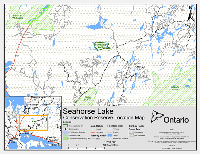
Enlarge this map of Seahorse lake conservation reserve location
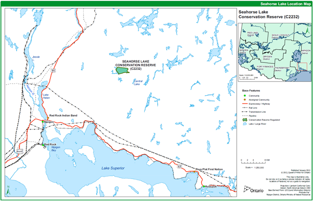
Enlarge this location map of Seahorse Lake conservation reserve.
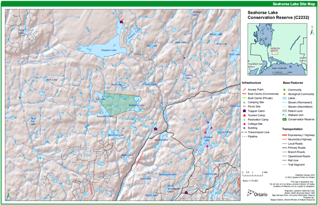
Appendix 2 - Site and values map of seahorse lake conservation reserve
Enlarge this site map of Seahorse Lake conservation reserve
Appendix 3 - Seahorse Lake Conservation Reserve - permitted uses
| Activity / Value | Permitted |
|---|---|
| Sport Hunting | Yes |
| Commercial Trapping | Yes |
| Boating / Canoeing / Kayaking | Yes |
| Baitfishing | Yes |
| Commercial Wild Rice Harvest | (N/A) |
| Mineral Exploration & Extraction | No |
| Land Disposition for Private Purposes | No |
| All-Terrain Vehicle | Modified |
| Snowmobile | Modified |
| Land Claims | District Manager approval required |
| Traditional Use | Yes |
| Native Hunt Camps | District Manager approval required |
| Commercial Tourism Based Hunting | Yes |
| Native Hunting | Yes |
| Commercial Native Trapping | Yes |
| Wildlife Management | Yes |
| Commercial Forest Operations | No |
| Vegetation Management (i.e. herbicides) | No |
| Timber Harvest for Personal Use | No |
| Fuelwood Harvest | No |
| Insect & Disease Suppression | District Manager approval required |
| Sport Fishing | Yes |
| Commercial Fishing | N/A |
| Native Fishing | Yes |
| Water Control Structures | No |
| Aggregate Extraction | No |
| Bear Management Areas | Yes |
| Trapline Cabins | District Manager approval required |
| Wild Rice Harvest | N/A |
| Boat Caches | District Manager approval required |
| Fire Management | Yes |
| Archeological Study | Yes |
| Backcountry Travel | Yes |
| Wildlife / Vegetation Viewing | Yes |
| Photography | Yes |
| Hiking | Yes |
| Rock Climbing | Modified |
| Mountain Biking | Modified |
| Nordic Skiing | Yes |
| Snowshoeing | Yes |
| Aircraft | Modified |
| Roads / Bridges / Culverts | No |
| Ongoing Research | Yes |
| New Research | Yes |
Definitions: Modified – use may be permitted under certain circumstances where the use would not impact the values for which the CR was created to protect (e.g. new trails, clearings/docks for aircraft access).
Appendix 4 - Landform vegetation (LV) combinations critical to the ecodistrict footnote *
Table of critical Landform Vegetation combinations
Description: Landform vegetation combinations that are critical to the Schreiber Ecodistrict (3W-5).
| LV | Landform | Vegetation |
| 19-2 | Organic Deposits | Open Marsh/Fen/Bog |
| 19-38 | Organic Deposits | Black Spruce Dominated |
| 19-39 | Organic Deposits | Tamarack Dominated |
| 19-47 | Organic Deposits | Intol Hdwd-Other Con Mixed |
| 4-39 | Precambrian Int. to Acidic Bdrck | Tamarack Dominated |
Footnotes
- footnote[*] Back to paragraph Gap Tool 2014 analysis for the Schreiber Ecodistrict (3W-5) using LVFRI dataset.