Swan Lake Conservation Reserve Management Statement
This document provides policy direction for the protection, development and management of the Swan Lake Conservation Reserve and its resources.
Ontario Ministry of Natural Resources
North Bay District
Approval statement
We are pleased to approve this Statement of Conservation Interest (SCI) for the Swan Lake Conservation Reserve (C114).
Swan Lake Conservation Reserve, located in Hills’ (1959) Ecodistrict 5E-5 as modified by Crins (2000), is dominated by upland deciduous forests on shallow soils, which have been created by hilly deposits of ground moraines. The conservation reserve is 256 hectares in size and is located in the geographic township of McConkey. The southeastern portion of the site has been designated as a forest reserve. This area contains a portion of the Portage Lake winter deeryard.
Swan Lake Conservation Reserve is one of 378 new protected areas approved through Ontario’s Living Legacy, a land use strategy aimed, in part, at completing Ontario’s system of parks and protected areas.
During the Lands for Life planning process the public was widely consulted and provided valuable input into what became Ontario’s Living Legacy. Comments received during that time, and during consultation related to the formal Public Lands Act regulation of the boundaries of this conservation reserve were generally supportive of the protection of this area.
Stakeholders who expressed an interest in the planning of this site were notified regarding the draft SCI and given a two-week review period. Any comments, including input from previous consultation, were considered in the finalization of this document. There was limited interest expressed by the public during the review of the draft SCI. No new issues have been identified. This SCI was also reviewed by MNR staff.
This SCI provides guidance for the management of the conservation reserve and the basis of the ongoing monitoring of activities. More detailed direction is not anticipated at this time. Should significant facility development be considered or complex issues arise requiring additional studies, more defined management direction or special protection measures, a more detailed Resource Management Plan will be prepared with full public consultation.
The majority of Swan Lake Conservation Reserve is managed under the direction of the District Manager and the Wasi Area Supervisor, North Bay District, Ministry of Natural Resources. The northern portion of the conservation reserve is managed by the District Manager and the Parry Sound Area Supervisor, Parry Sound District.
Prepared by: Cora A. Sheppard, OLL Planning Intern
December 01, 2003
Original signed by
Dave Payne
District Manager
North Bay District
Date: December 17, 2003
Original signed by
Rob Galloway
Regional Director
Northeast Region
Date January 9, 2004
1.0 Introduction
The purpose of this Statement of Conservation Interest (SCI) is to identify and describe the values of the Swan Lake Conservation Reserve and the associated forest reserve. The SCI also outlines the activities that occur within the conservation reserve and provides guidelines for the management of current and future activities in the context of protecting the natural, social and cultural values of the conservation reserve. A SCI is prepared under the authority of Procedural Guideline A – Resource Management Planning (PL. Procedure 3.03.05).
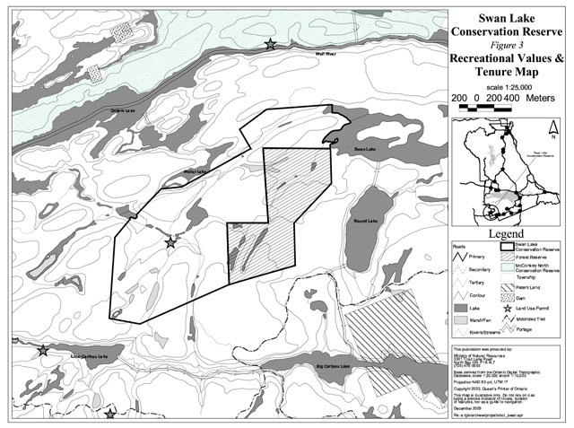
The Swan Lake Conservation Reserve is located in McConkey Township within both North Bay and Parry Sound MNR Administrative Districts. The conservation reserve is situated approximately 10 km west of the hamlet of Loring. The shallow-soiled area is dominated by upland deciduous forests, which have been created by hilly deposits of ground moraines. The site consists of 256 hectares of Crown land (Figure 1 and 3).
Conservation reserves are established by regulation under the Public Lands Act. Swan Lake Conservation Reserve was established by Ontario Regulation 313/02, under authority of the Public Lands Act (O. Reg. 805/94) on December 7, 2002. The planning area for this SCI is the regulated boundary of the conservation reserve. There is also an associated forest reserve with this conservation reserve that will be guided by this SCI (see Section 2.5).
1.1 Planning context
Ontario’s Living Legacy Land Use Strategy was approved in 1999. The objectives of the Land Use Strategy are to complete Ontario’s system of protected areas; recognize the land use needs of resource-based tourism industry; provide forestry, mining and resource industries with greater certainty around land and resource use; and enhance hunting, angling and other Crown land recreational opportunities. Swan Lake Conservation Reserve was created as part of the expansion of protected areas.
Conservation reserves protect natural heritage values on public lands, while permitting compatible land use activities. By allocating these lands to the parks and protected areas system through regulation, the province has ensured a certain level of permanence by distinguishing the conservation reserve and its values from the larger general use or more extensively managed landscape. In addition, the conservation reserve’s natural features are, and will be available for present and future generations to enjoy and explore.
Ontario’s Living Legacy Land Use Strategy (1999) outlines the general land use policy and management direction for new conservation reserves. Each new conservation reserve will have a planning document, either a SCI or, in more complex situations, a Resource Management Plan, that details site-specific management direction.
Comments received during the Lands for Life process, and during consultation related to the formal regulation of the boundaries of this site were generally supportive of the establishment of this area as a conservation reserve. Stakeholders who expressed an interest in the planning were notified regarding the draft SCI and given a two-week review period where the draft was made available. Any comments, including input from previous consultation, were considered in the finalization of this document. There was limited interest expressed by the public during the review of the draft SCI. This SCI was also reviewed by MNR staff.
Although more detailed direction is not anticipated at this time, should significant facility development be considered or complex issues arise requiring additional studies, more defined management direction or special protection measures, a more detailed Resource Management Plan will be prepared with full public consultation.
1.2 Background information
The Swan Lake Conservation Reserve protects stands of red maple and hemlock mixed with white cedar, poplar and white birch. The area encompasses part of the Portage Lake winter deeryard. The boundaries have been established predominantly using vectors but also using the biological units of Swan Lake in the northeast and Wetter Lake in the northwest.
The following chart summarizes administrative information for Swan Lake Conservation Reserve:
[Chart converted into a list]
- Name and OLL ID Number: Swan Lake Conservation Reserve (C114)
- Ecoregion/Ecodistrict (Hills, 1959; Crins, 2000): 5E Georgian Bay, 5E-5 North Bay
- OMNR Administrative Regions/Districts/Areas: Northeast Region/North Bay District/ Wasi Area
Southcentral Region/Parry Sound District/ Parry Sound Area - Total Area (ha.): 256
- Regulation Date: December 7, 2002 (O. Reg. 805/94)
- Township(s): McConkey
- First Nations: Robinson-Huron Treaty
Nipissing First Nation, Henvy Inlet First Nation and
Dokis First Nation traditional area - OBM map sheets: 2017 5600 50800
2017 5600 50900 - Topographic Map Name/Number: 41 H/16, Noganosh Lake
- UTM coordinates: 566,200 m E
5,089,200 m N - General Location, Description, Access: Approximately 10 km west of the hamlet of Loring. Site contains provincially significant life science areas. There is limited vehicular access to the site. Access is gained by an existing winter logging road that branches from an Ontario Federation of Snowmobile Clubs trail to the southeast.
1.3 Goals
The goals of this SCI are:
- To provide background information.
- To identify and describe the values of the conservation reserve.
- To provide guidelines for the management of current and future activities while protecting natural, social and cultural heritage values.
1.4 Objectives
The following objectives are identified as a means to achieve the above-stated goals.
- To describe the state of the resource with respect to natural heritage values and current land use activities.
- To manage the conservation reserve to protect the integrity of its natural values via specific guidelines, strategies and prescriptions.
- To meet planning requirements by addressing the management intent of the conservation reserve and addressing planning and management needs.
- To create a public awareness of the values within the conservation reserve and promote responsible stewardship of the protected area through partnerships with local stakeholders.
- To determine long-term management goals of the conservation reserve by identifying research, client services and marketing strategies.
- To identify scientific values on the site in relation to provincial benchmarks and identify the necessary monitoring and/or research to maintain the integrity of those values.
- To provide direction to evaluate new uses or economic ventures through the application of Test of Compatibility ((Procedural Guideline B) - Land Uses - PL. 3.03.05) (Appendix 1).
1.5 Representation
The following provides a summary of the life science, earth science and cultural heritage values, as well as recreational opportunities.
Life science representation:
The following landform types and vegetation associations are found within the conservation reserve (Burkhardt et al, 2003):
- Upland deciduous forests on shallow soils
- Treed wetland and stands of hemlock, red maple and white cedar
- Wetlands consisting of open water marshes, meadow marshes, shore fens and thicket swamps
Earth science representation:
The conservation reserve is within the Georgian Bay ecoregion (5e) which is characterized by Precambrian rocks and lowland areas of water-laid materials, frequently broken by bedrock outcrops and upland areas of rolling bedrock covered to variable depths with materials ranging from gravel to silty sands (Hills, 1959). Three are three different landforms in the conservation reserve (Kristjansson in Burkhardt et al, 2003).
Cultural heritage values:
No in-depth research has been completed to date. District cultural heritage maps were reviewed and no values were identified.
Recreational opportunities:
The area is heavily used for big game hunting such as deer and moose hunting. Other uses include camping associated with canoeing on the Wolf River system, hiking and nature study (Tremblay, 2002).
1.6 Survey work
The following table provides an overview of inventories completed, their level of detail, and any further inventories that are required.
| Survey Level | Life Science | Earth Science | Cultural | Recreational |
|---|---|---|---|---|
| Reconnaissance | Burkhardt, B., King, L., & Longyear, S. 2003 Life Science Checksheet, Aerial Survey |
Kristjansson, F.J., 2003, Earth Science Checksheet, Aerial Survey (in progress) | No values identified | Tremblay, D., 2002. Recreation Checksheet, Aerial and Ground Survey |
| Detailed | None | None | None | None |
| Requirement | None | None | None | Monitor on on-going basis |
2.0 State of the Resource
The conservation reserve is located entirely within Ecodistrict 5E-5 (Crins, 2000). Values include life science, earth science, cultural and recreational/aesthetic with an emphasis on the life sciences.
Significance is determined on the basis of the following criteria: representation, diversity, condition, ecological considerations and special features (Crins and Kor 1998).
-
Representation: The Swan Lake Conservation Reserve is located within the Sudbury-North Bay (L.4e) section of the Great Lakes – St. Lawrence Forest (Rowe 1972). This section surrounds Lake Nipissing and extends west to Lake Huron. It is characterized by areas of lowlands and flats interrupted by rugged outcrops of bedrock. The conservation reserve is dominated by hemlock with tolerant hardwood selections and rich upland mix. The cedar mixed wood forest is located in the southwest corner of the conservation reserve, along the south creek into Swan Lake Conservation Reserve. The large hemlock found within the conservation reserve shelters deer from snow accumulations. The conifer and deciduous forests support marten, fisher, bear, moose, deer and grouse.
The wetlands in this conservation reserve consist of open water marshes, shore fens and thicket swamps. These wetlands support excellent aquatic bird habitat as well as mammals such as muskrat and beaver.
-
Diversity: Diversity is a measure of the conservation reserve’s earth and life science variety. The evaluation is based on the number and range (assortment) of landscape features and landforms for earth science values and the relative richness and evenness of the site’s life science components.
The diversity of this conservation reserve is considered low. There are 9 different forest communities and the site is dominated by hemlock mixedwoods and hard maple forest communities. The smaller communities, under ten hectares, add little diversity to the conservation reserve. The forest communities are fairly even-aged with only 2 forest communities as candidates for old growth. There is one landform of moderately broken bedrock in the conservation reserve and associated forest reserve.
- Condition: Human disturbance is found in the winter logging road that runs through the site. When this SCI was prepared, this winter logging road was moderately grown-in and suitable for hiking, cross-country skiing or limited ATV use in its current condition; this condition will change when the road is used again in the future to access timber stands outside of the conservation reserve. The other known disturbance is a private recreational camp on an existing land use permit (LUP). No harvesting has occurred in or around the site. Natural disturbance has included past beaver activity.
- Ecological considerations: Most of the conservation reserve is bounded by vectors except for some small biological boundaries along lakeshores. As a result, there is little protection from intrusive influences especially since the landscape looks the same inside and outside the site. The overall design of the boundaries poorly captures core stands and biological units. When the forest reserve is added the stands will be better captured within the conservation reserve boundary (see Section 2.5).
- Special Features: The main feature for this site is the pristine landscape with little to no human disturbance. There is also little disturbance outside the conservation reserve boundaries. The rock outcrops on the creek flowing from Swan Lake are a feature of note in the area. The hemlock and maple mixed forests provide an attractive feature to the conservation reserve.
2.1 Life science
Gap analysis is a method of identifying gaps in representation of all landform/vegetation features within the Ecodistrict, and to identify potential sites that best fill those gaps. The objective of gap analysis is to complete representation of all vegetation community and landform types within protected areas (Bergsma, 1995). This conservation reserve was identified through gap analysis and contains 9 different forest communities.
The conservation reserve was established based on its dominance of upland deciduous forests on shallow soils created by hilly deposits of ground moraines. The forests provide ideal wildlife habitat, specifically as a winter yard for deer. The large hemlock canopies shelter deer from snow accumulations (Burkhardt et al, 2003).
The major forest communities in the conservation reserve are hemlock mixedwood, maple, cedar mixedwoods and poplar mixedwood. The cedar mixedwood forest in the southwest corner of the site and the conifer forest along the south creek into Swan Lake are candidate old growth stands (Burkhardt et al, 2003).
2.2 Earth science
The conservation reserve is located within the Laurentian Highlands of the Laurentian Region Physiographic Subdivision. The Laurentian Highlands are upland areas that extend south of the Ottawa River and include the spur of hills formed of Precambrian rocks that cross the St. Lawrence River (Bostock, 1970). The majority of the site is composed of moderately broken bedrock. There are three different earth science landforms on the site including:
- Discontinuous till with moderated bedrock exposure in the northeast and southwest corners of the site,
- Thin, continuous till with minor bedrock found throughout most of the site, and
- Areas of organic deposits on either bedrock or till (Krisjansson in Burkhardt et al, 2003)
2.3 Cultural values
There are no archeological sites identified within the conservation reserve. There are some identified high potential heritage areas. High potential cultural heritage areas are identified using a computer based predictive modeling program. Based on a series of pre-defined parameters, the program identifies candidate areas, which are most likely to be culturally significant.
2.4 Recreational/aesthetic values
The area supports populations of mammals, aquatic birds, waterfowl, large game and upland birds. This provides recreation opportunities for large game, upland and waterfowl hunting, wildlife viewing, nature study and hiking. The area is used extensively for hunting large game. The many small waterbodies within the conservation reserve are suitable for canoeing and angling. There is also camping within the site associated with hunting and canoeing on the Wolf river system to the north of the conservation reserve. A hunt camp is located in the centre of the conservation reserve on an existing land use permit. The site can be accessed through a winter logging road extending from an Ontario Federation of Snowmobile Clubs (OFSC) trail passing to the south east of the conservation reserve. The winter logging road extends from the southern boundary up through the conservation reserve, exiting at the northeastern boundary.
2.5 Forest reserve
This conservation reserve contained two mining claims at the time of regulation, which have been designated as forest reserve. This forest reserve is approximately 100 hectares.
A forest reserve is a land use designation applied to areas that were initially identified for inclusion in the conservation reserve but where subsequent detailed examination determined that there were existing mining claims or leases.
Mining and surface rights have been withdrawn from staking within the conservation reserve boundaries under the Mining Act (RSO 1990 Chapter M.14). Therefore, no new claims can be staked within the conservation reserve boundary. The intent is that forest reserve areas will be added to the conservation reserve if a claim or lease is retired through normal process.
Policies for forest reserves are similar to the policies for new conservation reserves, except that mining and related access will be allowed in a forest reserve. Management of this forest reserve will be guided by this SCI.
2.6 Enhanced Management Area
Enhanced Management Areas (EMAs) are a new land use category created in the Ontario’s Living Legacy Land Use Strategy. The EMA designation was established in order to provide more detailed land use direction in areas of special features or values. Swan Lake Conservation Reserve and Forest Reserve are surrounded by two EMAs. The North Pickerel River EMA (E112a) is a remote access category EMA, which is based on a pre-existing Restricted Access Area that was designated in the 1983 MNR Parry Sound District Guidelines (DLUG). The North Parry Sound Area EMA (E119r) is a recreation category EMA. The conservation reserve is in a large area providing opportunities for tourism, recreation and resource management in a relatively remote setting.
2.7 Heritage estate contributions
Swan Lake Conservation Reserve is a pristine area with many wildlife viewing opportunities in a relatively remote setting. This area may not be diverse in terms of vegetation, but the hemlock stands provide cover for wildlife. As previously mentioned the conservation reserve is part of the Portage Lake winter deeryard. This provides opportunities for deer study in winter months. The conservation reserve is also an excellent location to stop if travelling on the Wolf River canoe route. Preserving the area in its pristine state may also be beneficial as a benchmark in future studies.
3.0 Management guidelines
3.1 Management planning strategies
The land use intent outlined in Ontario’s Living Legacy Land Use Strategy provides context and direction to land use, resource management, and operational planning activities on Crown land. Commitments identified in the above strategy, provincial legislation and regulations, and MNR Policy (PL Procedure 3.03.05) will form the basis for land use within Swan Lake Conservation Reserve. For up-to-date information on permitted uses refer to the Crown Land Use Atlas.
Existing permitted uses within the conservation reserve may continue, unless they are shown to have a significant negative impact on the values within the site.
Proposed new uses and development within the conservation reserve will be reviewed on a case- by-case basis. A Test of Compatibility (Appendix 1) must be passed before they are deemed acceptable. The emphasis will be on ensuring that the natural values of the conservation reserve are not negatively affected by current or future land use activities. Therefore, any application for new specific uses will be carefully studied and reviewed. The Ministry, partner organizations and/or proponents may undertake such studies. Applicable environmental assessment requirements will also be met.
3.2 Land tenure
Background:
Swan Lake Conservation Reserve consists entirely of Crown lands and is surrounded by Crown land (Figure 1 and 2).
There is an existing private recreation camp within the conservation reserve authorized by a land use permit (LUP) under the authority of the Public Lands Act.
Guideline:
The sale of Crown lands within the conservation reserve is not permitted.
Existing recreation camps are permitted to continue. They may be eligible for “enhanced” tenure, but are not eligible for purchase of land. There are two forms of enhanced tenure that may be considered:
- Upgrade in the nature or type of tenure (e.g. from Land Use Permit to a lease); and/or
- An extension in the term of the tenure (e.g. from 1 year to 10 years).
Applications for enhanced tenure will be approved if determined acceptable using screening criteria. A change in tenure does not convey a commitment to provide for, or agree to, a change in the type or the standard of existing access to the recreation camp.
New recreation camps are not permitted.
Unauthorized occupations of lands within the conservation reserve will be handled in accordance with approved policy, and any required structural removal will be at the owner’s expense.
3.3 Development and access
Background:
There are no known structures, developments or facilities with the conservation reserve, except the existing private recreation camp.
There is an existing winter logging road that traverses the conservation reserve. This winter logging road is suitable for all-terrain vehicles, snowmobiles and hikers; such trail uses may not always be feasible, since the logging road will be used at some point in the future to access timber outside the conservation reserve. The conservation reserve can also be accessed from the Wolf River canoeing route.
The conservation reserve is located within a restricted access area under the Parry Sound District Land Use Guidelines.
Guideline:
New roads for resource extraction and/or private use will not be permitted, nor will additions to existing roads or upgrading of existing private roads be permitted.
The existing winter logging road may be essential for continued use beyond the conservation reserve for forest management purposes. Where alternative access does not exist or road relocation is not feasible, this road will continue to be available for access. Continued use will include maintenance and may include future upgrading by the forestry industry. Use will be consistent with direction for the area (Parry Sound DLUG, EMAs, Forest Management Plan).
Restricted access area direction from the 1983 Parry Sound DLUG will continue to apply to the conservation reserve. This direction was confirmed through the designation of E112a (North Pickerel River Area) in the Land Use Strategy.
Public access will be restricted to existing trails and present means of access in place in 1983, and to boat-in, fly-in or walk-in. New recreational trails, and up-grading of existing trails, are not permitted.
Existing authorized snowmobile trails may be permitted in conservation reserves as long as they do not impair the natural features and values for which the area is identified and as long as there are no significant environmental impacts.
The use of existing unauthorized trails will be monitored to ensure that conservation reserve values are not being adversely impacted. Depending on the results of the monitoring, some of the unauthorized trails may need to be redirected from sensitive areas or eliminated completely.
While there is no intent at present to provide or permit any new development in this conservation reserve that would require lighting, should this be considered at some point in the future, the MNR will not allow unnecessary, undirected light pollution. This commitment recognizes the wilderness values provided by a pristine night sky.
3.4 Recreational activities
Background:
Existing recreational uses include hunting, canoeing, camping, snowmobiling, all-terrain vehicle use and general nature activities.
The distance of this conservation reserve from urban areas has resulted in a relatively pristine night sky, which enhances the sense of remoteness and wilderness of this site. Pristine night skies are considered a significant value, given the increasingly limited areas of southern and central Ontario which are not heavily affected by light pollution.
Guideline:
Most recreational activities that have traditionally been enjoyed in this area can continue provided they pose no threat to the natural ecosystems and features protected by the conservation reserve.
Mechanized travel is permitted only on existing trails. Off-trail mechanized travel is permitted for retrieval of game only.
New recreational activities will be considered on a case-by-case basis. Emphasis will be placed on activities that have a low impact on the environment of the conservation reserve, and must rely on existing means of access.
3.5 Industrial activities
Background:
Swan Lake Conservation Reserve is located within the Nipissing Forest and French-Severn Forest but has been removed from the licensed areas. An examination of the possible impact of activities on adjacent lands should be considered in the Forest Management Plans.
There are no existing mining, timber harvesting, aggregate extraction or utility activities within the conservation reserve.
Mining and surface rights have been withdrawn from staking within the conservation reserve under the Mining Act (RSO Chapter M.14).
Guidelines:
Conservation reserve regulations do not permit mining, commercial forest harvesting, hydroelectric power development, the extraction of aggregate and peat or other industrial uses (Public Lands Act, Ontario Regulation 805/94).
Under the OLL Land Use Strategy, mining and related access will be allowed in a forest reserve. For those activities that could negatively influence the natural heritage values within the forest reserve and/or the conservation reserve, the district will work with the proponent to identify and mitigate potential mining or natural heritage concerns.
Mining will not occur in any portion of the regulated conservation reserve boundary.
3.6 Commercial activities
Background:
The entire conservation reserve is within parts of two registered traplines (PS-60 & PS61) managed in the Parry Sound District and one baitfish license area. The entire conservation reserve is within portions of two Bear Management Areas (BMAs) managed in the Parry Sound District (PS-47-0009 & PS-47-010). The Ministry of Natural Resources authorizes these activities.
Guideline:
Existing non-industrial commercial uses such as trapping and baitfish harvesting will be permitted to continue. These activities will continue to be monitored in order to ensure they do not deplete natural resources and that they impose a minimal impact on the features identified for protection.
New non-industrial commercial activities (ie. traplines) which overlap with the conservation reserve may be considered subject to a Test of Compatibility (Appendix 1), consistent with provincial direction. New trappers trails associated with the new non-industrial commercial activities may be considered subject to a Test of Compatibility.
New trap cabins in the conservation reserve will not be permitted.
Existing commercial bear hunting operations are permitted to continue, and transfers are permitted. The introduction of new operations will not be allowed.
The issuance of Licences to Provide Bear Hunting Services will be allowed where areas have been licensed or authorized under agreement for the activity since January 1, 1992 (there must be documentation in Ministry files that commercial bear hunting has been licensed during the period January 1, 1992 to present) unless:
- The Government has taken action to discontinue the activity; or
- Proceeding would create/aggravate resource sustainability issues (e.g., wildlife management reasons, imparts on values); or
- Licensing or permitting should be deferred due to Aboriginal issues.
Licences to Provide Bear Hunting Services will not be issued in areas where issuance has not occurred since January 1, 1992.
3.7 Aboriginal interests
Background:
This site is located within the Robinson – Huron Treaty Area of 1850, and as such the general area of this conservation reserve is known to be of interest to various First Nations. The conservation reserve is located within Nipissing First Nation’s traditional area.
Guideline:
All aboriginal and treaty rights will continue to be respected and are not affected by the establishment of this conservation reserve.
Any future proposals or decisions that have potential impact(s) on the individual or aboriginal or community values will involve additional consultation with the affected aboriginal groups.
3.8 Natural resource stewardship
The vegetation in this area consists of hard maple, yellow birch, hemlock and white pine. The forests are dominated by hemlock and mixed maple stands. Other communities present in the conservation reserve include white cedar and aspen stands. The area is considered pristine with little disturbance. There is some disturbance associated with human recreation including trails and camping. There is also an existing recreation camp in the centre of the conservation reserve.
Guideline - vegetation:
The conservation reserve will be managed by allowing natural ecosystems and processes to function as they would with minimal human interference. An exception would be to manage deer habitat.
Swan Lake Conservation Reserve is located in the Portage Lake deer yard. The Ontario’s Living Legacy Land Use Strategy (Appendix A – Land Use Intent) provides direction that “Vegetation management (deer habitat) to be addressed in Statement of Conservation Interest.” Such land use and resource management policy direction for vegetation management and featured species management is consistent with Conservation Reserve Policy PL 3.03.05.
The purpose of habitat management would be preservation and in some cases regeneration of the conifer trees, especially hemlocks, which provide cover from winter conditions, along with the creation of areas of browse in close proximity to conifer cover. It is anticipated that this habitat management would occur during the winter, thereby alleviating the need for any new/upgraded roads to undertake this activity.
Prior to work of this nature being done, a vegetation management plan would be completed by MNR and approved by the MNR North Bay District manager. This vegetation management plan would be directed by local MNR specialists (e.g. area forester, area wildlife biologist) and reviewed with life science specialists/ecologists of Ontario Parks, to ensure that the habitat management would not adversely affect the natural heritage and ecological representation values of this conservation reserve. Depending on the size of the areas to be managed, this vegetation management plan may also be reviewed with local and provincial organizations that may have an interest in this area of this habitat management activity. The habitat management prescriptions would generally be consistent with the approved Area of Concern provisions used for forestry operations in identified deer yard in the French-Severn Forest Management Plan and Nipissing Forest Management Plan, which in turn is derived from Forest Management Guidelines for the Provision of White-Tailed Deer Habitat OMNR 1997, except where modifications are needed to protect certain heritage values or features of this conservation reserve.
The MNR recognizes fire as an essential process fundamental to the ecological integrity of conservation reserves. In accordance with existing Conservation Reserve Policy and the Forest Fire Management Strategy for Ontario, forest fire protection will be carried out as on surrounding lands.
Whenever feasible, the MNR fire program will endeavour to use “light on the land” techniques, which do not unduly disturb the landscape, in this conservation reserve. Examples of light on the land techniques may include limiting the use of heavy equipment or limiting the number of trees felled during fire response efforts.
Opportunities for prescribed burning to achieve ecological or resource management objectives may be considered. These management objectives will be developed with public consultation prior to any prescribed burning, and reflected in the document that provides management direction for this conservation reserve. Plans for any prescribed burning will be developed in accordance with the MNR Prescribed Burn Planning Manual, and the Class Environmental Assessment for Provincial Parks and Conservation Reserves (approval pending).
Personal use permits for wood harvesting are not permitted.
Programs may be developed to control forest insects and diseases in the conservation reserve where these threaten significant values in or adjacent to the site. Where insects or disease threaten significant values, in or adjacent to the site, control will be directed as narrowly as possible to the specific insect or disease. Biological control will be used whenever possible. Regard shall be had for the Test of Compatibility.
Guideline - Fish and wildlife:
Fish and wildlife resources will continue to be managed in accordance with policies and regulations prevailing in the area and under the direction of the Wasi Area Supervisor. Provincial legislation and policy will dictate management and enforcement objectives for this area.
3.9 Cultural resource stewardship
Background:
No specific cultural studies or inventories have been undertaken within the conservation reserve, and no specific significant cultural resource values have been evaluated or identified to date.
Guideline:
Should the MNR consider new structural development, significant clearing of vegetation or altering of land within this conservation reserve, the MNR will adhere to the cultural heritage resource screening process as is identified in its Memorandum of Understanding (MOU) with the Ministry of Culture (MCL). While the purpose of this MOU is to provide a process to identify and protect cultural heritage resources when the MNR is reviewing work permits of disposing of Crown rights under the authority of the Public Lands Act, the considerations and criteria would also enable the MNR to identify high potential cultural heritage areas for other purposes within conservation reserves. If the screening process indicates that the site of a proposed activity is within an area of high cultural heritage potential, the MNR will consult with the MCL to determine the appropriate cultural heritage assessment requirements and will undertake a preliminary archaeological assessment if appropriate.
3.10 Client services
Background:
The access to the conservation reserve is generally confined to local use for current recreation activities. There are currently no client services associated with this conservation reserve.
Guideline:
The focus will remain on low key information and self-interpretation of conservation reserve features. Messages should focus on the area’s natural heritage features, recreation opportunities, nature appreciation and education.
Information regarding the Swan Lake Conservation Reserve may be delivered from different sources, however, MNR will be the lead agency for responding to inquiries. A management agreement may be pursued with an appropriate partner to share responsibilities for information services and the delivery of other aspects of this SCI.
Consideration will be given to the strategic location of signs where roads or trails cross the conservation reserve boundary. There are no other plans for structural development within this conservation reserve.
3.11 Monitoring, assessment and research
Background:
Research and assessment to date has included an earth science, life science and recreation checksheet.
Guideline:
Consideration will be given to inventory and documentation of natural and cultural values, and the assessment of use/activity impacts. All research will be carried out in a non-destructive manner. Research proposals must follow Procedural Guideline C – Research Activities in Conservation Reserves (PL 3.03.05).
The collection/removal of vegetation and parts thereof will not be permitted; however, subject to a Test of Compatibility (Appendix 1), the Area Supervisor may authorize the collection of plants and/or parts for purposes of rehabilitating degraded sites within the conservation reserve and collecting seeds for maintaining genetic stock or research.
Research, education and interpretation will be encouraged to provide a better understanding of the management and protection of the natural heritage values and will be fostered through local and regional natural heritage programs, initiatives and partnerships.
3.12 Marketing
Background:
There has been no marketing of this conservation reserve to date. Promotion and information about this site has been primarily through the Ontario’s Living Legacy planning process and public consultation regarding the boundaries of this site.
Guideline:
Marketing activities of this conservation reserve will be kept to a minimum.
4.0 Implementation
Implementation of the SCI and management of the conservation reserve are the responsibility of the Wasi Area Supervisor, North Bay District of the Ministry of Natural Resources and the Parry Sound Area Supervisor, Parry Sound District in the northern portion of this conservation reserve within Parry Sound District.
Emphasis will be placed on awareness information highlighting conservation reserve values and appropriate uses, given the area’s status of Restricted Access Area in the Parry Sound District Land Use Guidelines.
Long-term management will consider the balance between maintaining the quality of representation and the needs of recreation and other uses.
5.0 Review and revision of the Statement of Conservation Interest
Swan Lake Conservation Reserve SCI will be reviewed on an ongoing basis and will include the monitoring of activities to ensure adherence to management guidelines. Partnerships may be pursued to address management needs.
This SCI will be amended through a standard process of minor and major amendments. Minor amendments will be processed in a relatively informal manner and will require the approval of the Wasi Area Supervisor and in the portion of the conservation reserve within Parry Sound District will also require the approval of the Parry Sound Area Supervisor. These amendments will deal with uses and activities that do not affect any of the policies in this SCI (e.g. new uses and/or activities that are consistent with existing permitted uses).
Uses and/or activities that were not anticipated in the approved SCI and which may have an impact on the values of the conservation reserve will require a major amendment. This will include an opportunity for public comment and input and will require the approval of the North Bay District Manager and Regional Director and in the portion of the conservation reserve within Parry Sound District will also require the approval of the Parry Sound District Manager and the Southern Regional Director.
6.0 References
Bergsma, B.M. 1995. Gap Analysis and Candidate Area Selection for Life Science Representation in Site District 5E-6. Ecological Services for Planning Ltd.
Bostock, H.S. 1970. Geology and Economic Minerals of Canada.
Burkhardt, B., King, Longyear, S. 2003. Swan Lake Conservation Reserve (C114) Draft Life Science Checksheet – Step 2.
Chambers, B.A., Naylor, B.J., Merchant, Uhlig, P. 1997. Field Guide to Forest Ecosystems of Central Ontario.
Crins, W. Uhlig, P.W.C. 2000. Ecoregions of Ontario: Modifications to Angus Hills’ Site Regions and Districts. Unpublished Paper. Peterborough: OMNR.
Crins, W. Kor, P. S. G. 1998. Natural Heritage Gap Analysis Methodologies Used by the Ontario Ministry of Natural Resources. Unpublished Paper. Peterborough: OMNR.
EMR Canada. 1995. Topographic Map 1:50,000. Noganosh Lake 41 L/16.
Hills, G.A. 1959. A ready reference to the description of the land of Ontario and its productivity. Ont. Dept. of Lands and Forests, Division of Research, Maple, Ontario.
Noble, T.W. 1991. Assessment of Natural Areas and Features for the Northern Portion of the Southern Boreal Forest Region Site Region 5E. Ontario Ministry of Natural Resources. 1989. Aerial Photos.
Ontario Ministry of Natural Resources. 1997. Public Lands Directive Manual: Natural Heritage - PL 3.03.05.
Ontario Ministry of Natural Resources. 1997. Forest Management Guidelines for the Provision of White-tailed Deer Habitat. Queen’s Printer for Ontario.
Ontario Ministry of Natural Resources. 1999. Ontario’s Living Legacy: Land Use Strategy. Peterborough: Queen’s printer for Ontario.
OMNR. North Bay District. 2003. C114 Swan Lake Conservation Reserve File.
OMNR. 1983. Parry Sound District Land Use Guidelines.
Rowe, J.S. 1972. Forest Regions of Canada. Department of Fisheries and the Environment- Canadian Forest Service Publication No. 1300.
Tremblay, D., 2002. Swan Lake Conservation Reserve Recreation Inventory Checksheet.
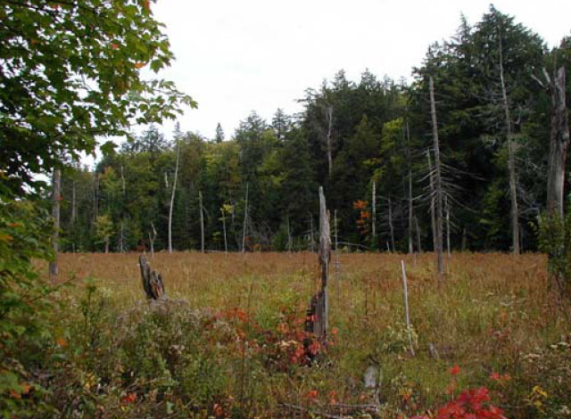
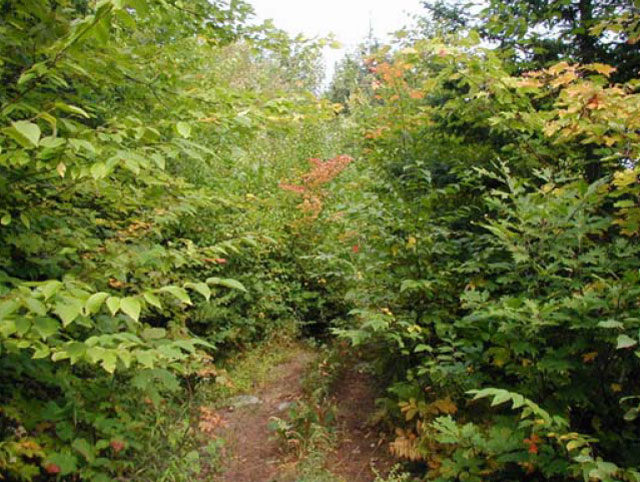
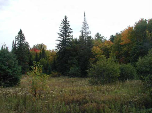
Photos of Swan Lake Conservation Reserve
Appendix 1: Procedural Guideline B – Land Uses – Test of Compatibility (PL Procedure 3.03.05)
The Conservation Reserve policy provides broad direction with regard to the permitted uses. The policy provides only an indication of the variety of uses that will be considered acceptable in conservation reserves. The only caution is that “any new uses, and commercial activities associated with them, will be considered on a case by case basis, and, they must pass a test of compatibility to be acceptable.” What does a ‘test of compatibility’ mean?
An examination of this must start from the premise of why an area is set aside – specifically, its representative natural heritage values. Criteria are then identified to guide compatibility considerations. These criteria apply to the long-term acceptability of both existing uses and new uses.
-
Conformity to SCI/RMP: SCI describe values for which an area has been set aside and the range of appropriate uses that will be permitted in the area. SCI may also speak to the acceptability of other ‘new’ uses currently not occurring in the area.
The first ‘test’ is: “do proposed new land uses and/or commercial activities conform to the direction of the SCI/RMP for the conservation reserve? Would the new use(s) depart from the spirit of appropriate indicator land uses in the SCI/RMP?”
-
Impact Assessment: If the proposed use(s) pass test 1 it is important to determine their impact on the area before they are approved. This should include the following:
- Impact on natural heritage values: “will the new use(s) impact any natural values in the area? If so how and to what degree? Is it tolerable?”
- Impact on cultural values: “will the new use(s) impact an historical or archaeological values in the area?”
- Impact on research activities: “will the new use(s) affect research activities in the area?”
- Impact on current uses: “will the new use(s) have any negative impact on the array of current uses?”
- Impact on area administration: “will the new use(s) increase administrative costs and/or complexity?” (For example, the cost of area monitoring, security and enforcement).
- Impact on accommodating the use outside the conservation reserve: “Could the use(s) be accommodated as well or better outside the conservation reserve?”
- Impact on socio-economics of the area: “will the new use(s) affect the community(ies) surrounding the area in a positive or negative way?” (For example, will the new use make an area less remote thereby affecting a local tourism industry that is dependent on the area’s remoteness for its appeal?
- Impact on area accessibility: “does the new use(s) give someone exclusive rights to the area or a portion of the area to the exclusion of other existing uses?”
The following table provides a guide of indicator uses for the consideration of uses that may be permitted within conservation reserves. For any specific conservation reserve that test of compatibility should be applied to determine which specific uses are acceptable.
Appendix 2: Public Lands Act Policy (3.03.05) Conservation Reserve
Permitted use table
Indicator uses for Conservation Reserves
Recreation
| Permitted Activities | Generic Existing |
Generic New |
(C114) Specific New Uses |
|---|---|---|---|
| Sport fishing | Yes | Yes | Yes |
| Sport hunting | Yes | Yes | Yes |
| Food gathering | Yes | Yes | Yes |
| Facility infrastructure | Maybe | Maybe | Maybe1 |
| Non-trail snowmobiling | Maybe1 | Maybe1 | Maybe2 |
| Non-trail ATV use | Maybe1 | Maybe1 | Maybe2 |
| Rock climbing/caving | Maybe | Maybe | N/A |
| Canoeing/kayaking | Yes | Yes | Yes |
| Motorized boating | Yes | Yes | Yes |
| Picnicking | Yes | Yes | Yes |
| Camping | Maybe | Maybe | Yes |
| Trails | Yes | No | Maybe1 |
| Trails: Hiking | Yes | No | Maybe1 |
| Trails: X-county skiing | Yes | No | Maybe1 |
| Trails: Cycling | Yes | No | Maybe1 |
| Trails: Horse riding | Yes | No | Maybe1 |
| Trails: Snowmobiling | Yes | No | Maybe1 |
M1 = New uses will be considered on a case by case basis provided they do not impact the natural heritage values for which the area was established, and must pass a test of compatibility to be acceptable.
M2 = For retrieval of game only
Science, education & heritage appreciation
| Permitted Activities | Generic Existing |
Generic New |
(C114) Specific New Uses |
|---|---|---|---|
| Research | Yes | Yes | Yes |
| General walking | Yes | Yes | Yes |
| Photography and painting | Yes | Yes | Yes |
| Wildlife viewing | Yes | Yes | Yes |
| Outdoor education/interpretation | Yes | Yes | Yes |
| Collecting | No | No | No |
Commercial activities
| Permitted Activities | Generic Existing |
Generic New |
(C114) Specific New Uses |
|---|---|---|---|
| Food harvesting | Maybe | Maybe | No |
| Fishing | Maybe | Maybe | No |
| Baitfish harvesting | Yes1 | Maybe | Yes |
| Trapping | Yes1 | Maybe | Yes |
| Trap cabins | Yes | No | No |
| Resort-outpost camp | Yes1 | No | No |
| Outfitting-bear management | Yes1 | No | Yes |
| Wild rice harvesting | Yes | Maybe | N/A |
Resource management
| Permitted Activities | Generic Existing |
Generic New |
(C114) Specific New Uses |
|---|---|---|---|
| Inventory monitoring | Yes | Yes | Yes |
| Featured species management | Maybe | Maybe | Maybe |
| Natural systems management | Maybe | Maybe | Maybe |
Industrial activities
| Permitted Activities | Generic Existing |
Generic New |
(C114) Specific New Uses |
|---|---|---|---|
| Timber harvesting | No | No | No |
| Prospecting | No | No | No |
| Mining | No | No | No |
| Hydro generation | No | No | No |
| Energy transmission corridors | Yes | No1 | No |
| Communications corridors | Yes | No1 | No |
| Transport corridors | Yes | No1 | No |
| Resource roads (MNR) | Yes | No2 | No |
| Land disposition | * | No | No |
| Hunt camps | Yes | No | No |
N1 = These new uses will be discouraged through the planning process.
N2 = New private access roads are not permitted.
* = Existing dispositions will continue, however, as opportunities arise the Ministry will acquire and/or remove them outside of the conservation reserve.
Figure 1: Location map
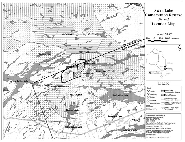
Figure 2: Forest values map
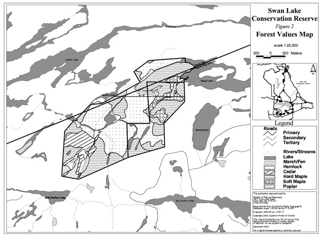
Figure 3: Recreational values and tenure map