Widgeon Lake Moraine Conservation Reserve Management Statement
This document provides policy direction for the protection, development and management of the Widgeon Lake Moraine Conservation Reserve and its resources.
February 2005
Prepared by Paul Gamble
Resource Planner, Wawa District
Approval statement
We are pleased to approve this Statement of Conservation Interest (SCI) for the Widgeon Lake Moraine Conservation Reserve (C1508). Recently, the Government of Ontario conducted a major land use planning exercise which resulted in the release of the Ontario’s Living Legacy Land Use Strategy (1999). The Land Use Strategy focuses on four specific objectives that were established to guide the planning process. These are:
- to complete Ontario’s system of parks and protected areas;
- to recognize the land use needs of the resource-based tourism industry;
- to provide forestry, mining, and other resource industries with greater land and resource use certainty; and
- to enhance hunting, angling and other Crown land recreation opportunities.
Direction for the establishment, planning and management of conservation reserves is defined under the Public Lands Act and the Crown Land Use Policy Atlas.
Widgeon Lake Moraine Conservation Reserve is located approximately 5 kilometers east of Pukaskwa National Park’s eastern boundary. The conservation reserve (CR) has an area of 1,240 hectares and consists of ground end moraine, a bedrock drift that has resulted in various forest cover the majority of which is between 30 and 120 years old. The CR is within the Black River Forest Management Unit in the Wawa District.
The public was invited to comment on the proposed boundary of Widgeon Lake Moraine CR in August/September of 2000. An opportunity was provided for the public to participate in the preparation of this SCI in January/February of 2002. The public will be invited to comment on the draft SCI in early winter 2004. Comments and concerns registered will be reflected in the final Statement of Conservation Interest. A final inspection opportunity will be provided for the public to review the approved SCI document. This document was prepared by an interdisciplinary planning team having expertise in forest ecology, biology, land management, and fire management. A draft was provided to the MNR Regional Planning Unit for review.
This Basic SCI provides guidance for the management of the Widgeon Lake Moraine Conservation Reserve and provides the basis for the ongoing monitoring of activities. More detailed direction is not anticipated at this time. Should significant facility development be considered or complex issues arise requiring additional studies, more defined management direction, or special protection measures, a more detailed Resource Management Plan will be prepared with full public consultation.
Submitted by:
original signed by
Paul Gamble
Plan Author
Date: February 24, 2005
Original signed by
Terry Taylor
District Manager
Date: February 25, 2005
Approved by:
Original signed by
Rob Galloway
Regional Director
Northeast Region
Date: April 10, 2005
1.0 Introduction
Widgeon Lake Moraine Conservation Reserve is located within Wawa District of the Ministry of Natural Resources Northeast Administrative Region. It is a 1,240-hectare site that was regulated as a Conservation Reserve (CR) in 2000. Located within the White River Forest Management Planning Unit, it is approximately 50 kilometers northwest of the town of Wawa. The site was recommended for Conservation Reserve status in the Ontario’s Living Legacy Land Use Strategy, approved in July 1999.
Direction for establishing, planning and managing conservation reserves is defined under the Public Lands Act and the Crown Land Use Policy Atlas. Statements of Conservation Interest are prepared under the authority of Procedural Guideline A – Resource Management Planning. (Policy 3.03.05, MNR 1997). "Ontario’s network of natural heritage areas has been established to protect and conserve areas representative of the diversity of the natural regions of the province, including species, habitats, features and ecological systems which comprise that natural diversity."
In late 1999, prior to regulation, consultation on boundary refinement was conducted with the current SFL holder Domtar Inc., local First Nations and the general public. Since public consultation regarding boundary refinement of the site generated little interest and higher level planning documents provide direction on most activities in the reserve, a more detailed Resource Management Plan is not required.
The purpose of this Statement of Conservation Interest (SCI) is to identify and describe the values of the proposed Widgeon Lake Moraine Conservation Reserve. The SCI also outlines the activities that occur within the proposed reserve and provides guidelines for the management of current and future activities in the context of protecting the natural and cultural values.
Conservation reserves complement provincial parks in protecting representative natural areas and special features. Most recreational activities (e.g. hiking, nature appreciation, sport hunting and fishing) are permitted, provided they do not impact the natural features being protected. Mining, hydroelectric power development and commercial forestry are prohibited by legislation and the approved Ontario’s Living Legacy Land Use Strategy (MNR, 1999) guides many other activities. The Widgeon Lake Moraine CR helps to contribute to the representation of the province’s ecosystems and natural features. The addition of the protected areas recommended by Ontario’s Living Legacy will help complete the Provincial Parks system within the planning area and protect 12% of its land and water base.
2.0 Goals and objectives
2.1 Goals of Statements of Conservation Interest
The goal of conservation reserves is to protect natural heritage and cultural values on public lands while permitting compatible land use activities.
2.2 Objectives of Statement of Conservation Interest
2.2.1 Short term objectives
The short-term objectives are:
- To identify the state of the resource with respect to natural heritage values and current land use activities for the conservation reserve.
- To manage the conservation reserve to protect the integrity of its natural values via specific guidelines, strategies and prescriptions detailed in this plan.
2.2.2 Long term objectives
The long-term objectives are:
- To establish representation targets (e.g. future forest conditions) and validate the site as a potential scientific benchmark
- To identify research/client services, and marketing strategies
- To give direction to evaluate future new uses or economic ventures
- To provide direction to evaluate new uses or economic ventures through the application of a Test of Compatibility (Procedural Guideline B – Land Uses PL 3.03.05 (Appendix 8.2).
- To create a public awareness of the values within the conservation reserve and promote responsible stewardship of the protected area through partnerships with local stakeholders.
- To identify scientific values on the site in relation to provincial benchmarks and identify the necessary monitoring and/or research to maintain the integrity of those values.
3.0 Management planning
3.1 Planning area
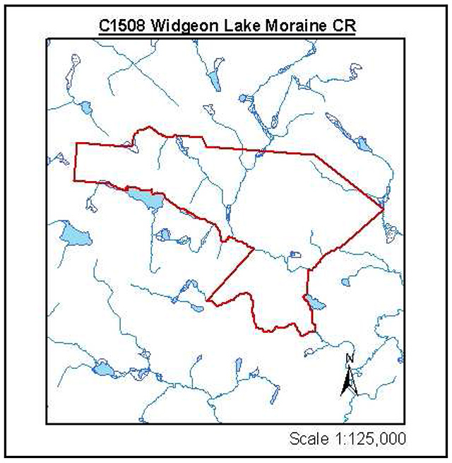
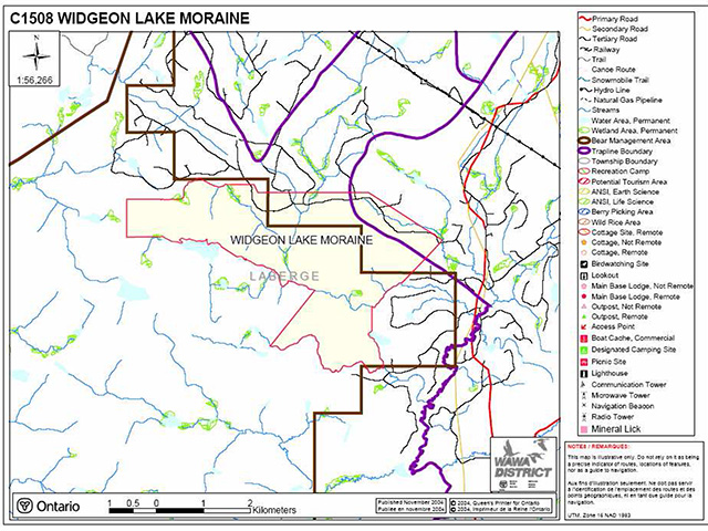
Conservation reserves are established by regulation under the Public Lands Act. Widgeon Lake Moraine Conservation Reserve was regulated as a conservation reserve on November 22, 2002. The planning area for this SCI is the regulated boundary of the conservation reserve (there are no Forest Reserves associated with this CR) (Appendix 8.1 Site Map).
For purposes of Resource Management Planning and for other land uses, particularly for Forest Management Planning, the boundary of the conservation reserve in itself will not be treated as a 'value'. Management Prescriptions presented in this plan will relate to the activities within the conservation reserve, will identify the location, shape, size, significance and sensitivity of natural heritage values, and will identify additional special features within the boundary of the site. Management actions outside the boundary of the conservation reserve will continue to consider the site’s natural heritage features, recreational values and protection requirements within larger landscape plans such as Forest Management Plans.
3.2 Management planning context
The Widgeon Lake Moraine Conservation Reserve and its associated permitted uses will receive its direction from the Ontario’s Living Legacy Land Use Strategy (MNR, 1999) and the Crown Land Use Policy Atlas. Subsequent planning will also follow the direction developed in this plan. By regulation, this reserve cannot be used for mining, commercial forest harvest, hydroelectric power development, peat/aggregate extraction or any other industrial use. The conservation reserve has been withdrawn from the White River Forest Sustainable Forestry License (SFL) and commercial forestry will no longer occur within its regulated boundaries. Since there has been no recent timber harvesting, post harvest silvicultural activities will not be required as a non-conforming use. Existing activities, such as sport fishing and hunting and existing bear management will continue to be permitted. The SCI and future management will attempt to resolve conflicts regarding incompatibility between uses and to ensure that identified values are adequately protected.
At present, there is no land in the CR under land tenure. In the future, land in the conservation reserve will not be sold or leased. New uses and potential commercial activities may be acceptable if they do not impact the natural heritage values of the site. Such activities will be considered on a case-by-case basis and reviewed using the Procedural Guideline B – Land Uses – Test of Compatibility PL 3.03.05 (MNR, 1997). Authorization for potential compatible uses will be in the form of a Land Use Permit or a License of Occupation.
Fish and wildlife management activities will generally occur in a manner similar to surrounding crown lands.
Fire Management is described in Section 6.3.
Specific land and resource use is described in Section 5.
3.3 Planning process
The level of management planning required to fulfill the protection targets is determined by the complexity of issues that need to be addressed. Guidelines for the preparation of this document are outlined in Procedural Guideline A for SCI and RMP PL 3.03.05 (MNR, 1997). This SCI will only address known issues or current proposals with respect to permitted uses or potential economic opportunities brought forward during the planning process. Future proposals for development or land use will be reviewed through a Test of Compatibility.
The planning process for the Widgeon Lake Moraine Conservation Reserve involves three public consultation phases. In January 2002, notices appeared in the Wawa, Manitouwadge and Marathon newspapers advising that planning for the CR was being initiated and inviting the public and interested organizations to supply background information and viewpoints. There was also a direct mail out to the public and to organizations known to be interested in or affected by the conservation reserve at this time.
The draft SCI will be available for public viewing and we will be incorporating any comments into the SCI that are necessary. In addition; newspaper notices have invited anyone interested to request a copy of the draft SCI.
The final public consultation phase will be an inspection of the MNR-approved SCI. The approved SCI will be available for public viewing at the District office. Following this consultation, the plan will be implemented.
Notices will not be placed on the Environmental Registry because this SCI is not considered a policy under the Environmental Bill of Rights.
4.0 Background information
4.1 Location and site description
The Widgeon Lake Moraine Conservation reserve is located approximately 5 kilometers east of Pukaskwa National Park’s eastern boundary, off of Paint Lake Road, which can be accessed south off Highway 17. It is also approximately 50 kilometers northwest of the town of Wawa. Additional location and administrative information can be found in Table 1.
4.1.1 Physical description
Widgeon Lake Moraine Conservation Reserve is a 1243 hectare parcel of Crown land with its configuration is comprised of vectored boundaries that dominate the northern, northeastern and western borders and biological boundaries including creek beds and lake shorelines along the southern limits of the site.
The reserve is located within the Tip Top Mountain Site District (3E-4) in the westernmost site of the Lake Abitibi Site Region (3E), (Hills, 1959; Crins and Uhlig, 2000).The Lake Abitibi Site Region is found to contain moderately to gently rolling bedrock, generally covered by deep deposits of clay, silt and sand (Hills, 1959). The Tip Top Mountain site District is characterized by strongly to moderately broken upland of granite rock covered by a shallow layer of granitic sand and silty sand. The forest climate type for this region is mid-humid, mid-boreal (Poser, 1992).
| Territorial District | Algoma |
|---|---|
| MNR Region/District | Northeast / Wawa |
| Township | Unorganized |
| Site Region – Site District | (Hills,2000) 3E-4 |
| Park Zone | Northeast |
| Regulation Date | November 22, 2002 |
| Total Area | 1240 hectares |
| Ownership | Crown |
| UTM Coordinates | 5340650N 612750E (Zone 16) |
| NTS Map Numbers | 42 C/3 (Mishibishu Lake) & 42 C/4 (Pukaskwa River) |
| OBM Map Numbers | 166005330 166105330 166005340 166105340 |
| Wildlife Management Unit: WMU 33 | Forest Management Unit: White River |
4.2 History of the site
The conservation reserve is within the Ojibways of the Pic River and the Pic Mobert First Nation traditional land use area; however, there are no known values. The site is in the area covered by the Union of Ontario Indians (UOI) and the Robinson-Superior 1850 Treaty area.
4.3 Inventories
Table 2 illustrates the inventories/surveys completed for Widgeon Lake Moraine Lake Complex CR, as well as any future requirements for earth and life sciences, cultural, recreational or other categories. The detailed Earth (Kristjansson, 2002) and Life Science Checksheets (Burkhardt, 2002), and sections 4.1 and section 5.0 describe the key features of the CR.
| Survey Level | Earth Science | Life Science | Cultural | Recreational |
|---|---|---|---|---|
| Reconnaissance | Kristjansson, F.J., 2002, Earth Science Inventory Checklist, Widgeon Lake Moraine Conservation Reserve (C1508) | Noordhof, J., et al Nov. 2002, Widgeon Lake Moraine Conservation Reserve Planning Life Science Checksheet. | Native Values Maps Manitouwadge Area (2001), and Pic River Values Map, 2003 | Fortin, S., 2001, Widgeon Lake Moraine Conservation Reserve (C1508) Recreation Resource Inventory Report. |
| Detailed | None | None | None | None |
| Requirement | None | Recommend further review | None | Recommend monitoring |
5.0 State of the resource
This section will identify the state of the resource within, bordering or crossing the boundary of the site. The state of the resource will include the natural heritage values present within the site and those values that are adjacent to but within the CR boundary or that may cross the conservation reserve’s boundary within the general use area where an artificial vectored boundary exists. Current land use activities including tenure and past and current development within the planning area will also be discussed.
5.0.3 Features represented in this conservation reserve
The Widgeon Lake Moraine Conservation Reserve was recognized by the Ontario Living Legacy Strategy as a provincially significant earth science site based on Gap Analysis by Noble (1988). This is based on the inventory of a provincially significant earth science end moraine that is located through the extreme north central and northwest part of the reserve (Kristjansson, 2002).
Widgeon Lake Moraine Conservation Reserve’s diversity is extensive recognizing that the site is less that 1200 ha in size. Three large bedrock drift complexes are found within and bordering the site. The largest, supports communities of white birch mixedwoods, balsam fir, or jack pine dominant stands, pure black spruce stands and poplar dominated stands and mixedwoods. There are also several areas where there are extensive jack pine dominated communities with smaller black spruce stands in pure dominant or mixedwood communities.
Wetlands are found mainly bordering the site, with two in the south central and central part of the site. The wetlands that are found along the site’s borders consist of wet meadow/poor fen combinations along with shore fens and meadow marshes (See Figure 1). There is a large wetland complex located in the central part of the site that contains an open poor fen and a treed fen in the southern half of the area (Noordhof, 2002).
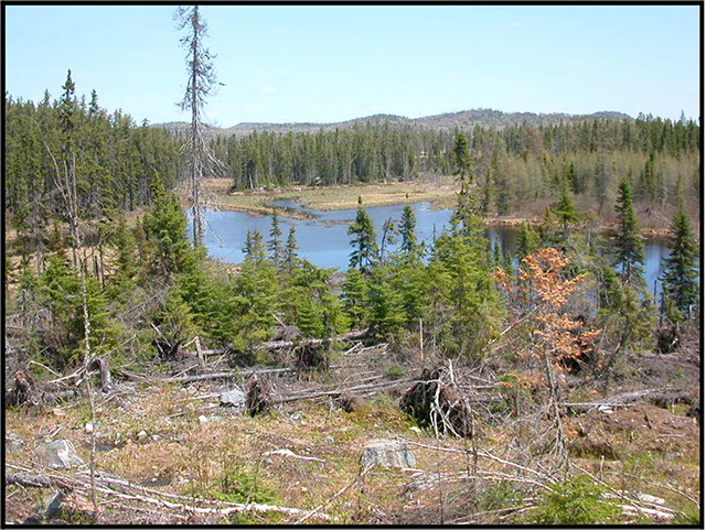
There are a number of small unnamed lakes and rivers surrounding and flowing through the site with the creeks found in the east and the south being drained by the Pukaskwa River located to the west of the site (Noordhof, 2002).
5.0.2 Quality of features represented
The quality of the representation and the current characteristics of the natural features found within the conservation reserve are as important as the overall representative features that are being protected. A number of factors are considered in the evaluation of the site, including; diversity, ecological factors, condition, special features and current land use activities.
Condition
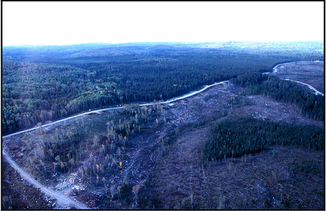
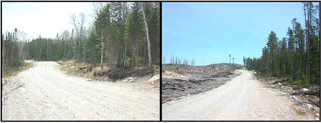
The disturbance around the site is said to be fairly high due to the amount of harvesting that has taken place around the site, both historically and recent to the regulation of the site. There are a number of roads that are currently being used by the Sustainable Forest License holder within close proximity of the site. There is one forest access road which is located within the site (see Map 6, Noordhof, 2002) that runs generally south of the northern boundary along the portion of the provincially significant earth science end moraine. The tree cover in the location of the end moraine has been cut; there is still a relatively large portion of the end moraine feature in good condition. There is also a transmission corridor found just north of the site.
Diversity
Diversity is a measure of the site’s life and earth science variability. It is based on the number and variety of natural landscape features and earth science values. The site is comprised of an even distribution of landforms/vegetative combinations. The most dominant landform/vegetative combinations include dense conifer stands of black spruce on glaciofluvial outwash deposits in the central and southern parts of the site. In addition there are predominantly deciduous stands of white birch on bedrock drift complex and dense conifer stands of jack pine present on outwash, bedrock drift and till deposits especially the provincially significant end moraine (Noordhof, J., et al, 2002).
Ecological factors
Ecological factors are significant to the quality of representation within the reserve and include size, shape, sensitivity to potential disturbances, and current linkages to the larger landscape. Although vectored boundaries occupy a large portion of the site, the use of lakes and creeks as biological boundaries in the southern and southwest parts of the site offer a strong protective potential for the core values of the site (Noordhof, 2002).
The Widgeon Lake Moraine CR is located in close proximity to Pukaskwa National Park and Pukaskwa River Provincial Park. The linkages between these sites should be maintained or renewed in order to sustain good gene flow among these protected areas.
Special features
There are no known significant wildlife features or habitat for vulnerable, threatened, or endangered (VTE) species in the conservation reserve. Widgeon Lake Moraine CR contains the provincially significant end moraine as described by Phil Kor (Phil Kor pers.comm from Noordhof, 2002) in the provincial earth science gap analysis and reconfirmed by Kristjansson (2002). Provincially significance concerning the life science features will have to be determined via a new life science gap analysis for the Site District 3E-4 (Noordhof, 2002)
Current land use activities
Current land use activities are limited to trapping, fishing and hunting (Fortin, S., 2001). The area is difficult to access due to road access restrictions by the MNR on the Forest Management Unit. The close proximity of Pukaskwa National Park will contribute to the use of the site being very low for the average person, since there will likely be a continuation of access restrictions to this side of the park in the future.
5.1 Social/economic interest in the area
Linkage to local communities
This conservation reserve contributes to the local community by providing an ecosystem that supports the production of wildlife. Local trappers, hunters and fishermen who harvest within the site indirectly benefit the local community economy.
Widgeon Lake Moraine Conservation Reserve is located in close proximity to Pukaskwa National Park and Pukaskwa River Provincial Park. Future opportunities to link the recreational value of these areas may also contribute to the local communities of White River, Manitouwadge and Marathon.
Heritage estate contributions
Widgeon Lake Moraine CR contributes to the province’s parks and protected areas by preserving a number of natural heritage values mentioned in the previous section (5.0). The lack of industrial disturbance and current land use in the CR will help to ensure that fragile vegetation communities, significant geological features and waters are protected into the future. Furthermore, the site’s distinctiveness as a record of glacial recession may distinguish this site as an important scientific benchmark in the years to come. Future managers will have to balance the need to maintain the quality of the current representation and the needs of present and future users.
Aboriginal groups
The conservation reserve is within the Ojibways of the Pic River First Nation’s and Pic Mobert First Nation’s traditional land use area; however, there are no known values at this time. Traditional Values Mapping exercises are taking place currently and if values are identified within or adjacent to the site, they will be properly mapped and documented to avoid disturbance and maintain discretion and protection.
Mining industry and Ministry of Northern Development and Mines
Although there is one active mining claim that borders the northeastern corner of the site, there are no Forest Reserve portions within the boundary of the Conservation Reserve. There were no Ministry of Northern Development and Mining issues at time of Regulation. Mineral Potential is considered low to moderate (Kristjansson, 2002).
5.2 Natural heritage stewardship (vegetative/plant community management and earth science value protection)
The life science targets achieved by the creation of this site are currently unknown because of recently redefined Ecodistricts (Burkhardt, 2002). A new gap analysis should be completed in order to determine the significance of the conservation reserve. As per Noble and Phillips (1988), the Widgeon Lake end moraine is considered to be provincially significant (Kristjansson, 2002). When considering the landform data for the Widgeon Lake Conservation Reserve it is important to point out that this site is an earth science site and the history of the site is based on earth science values not on a life science gap analysis (Burkhardt, 2002).
There is no present monitoring or research program being conducted in conjunction with this conservation reserve.
Current fire management is concurrent with that practiced on adjacent crown land. Management strategies are described in section 6.2 State of the Resource Management Strategies.
5.3 Fisheries and wildlife
Widgeon Lake Moraine Conservation Reserve is home to large wildlife species such as black bear and moose. The conservation reserve is also inhabited by a number of small game species such as snowshoe hare, beaver, and otter. Inventories have not been conducted to verify the other wildlife species that may utilize this site.
There have been no identified lake surveys in which water quality data was collected within the conservation reserve.
There have been no inventories performed for vulnerable, threatened and endangered species at risk. Additional studies and subsequent development of protection/restoration plans would be conducted if warranted.
5.4 Cultural heritage stewardship
There are no known archaeological or cultural heritage values in the conservation reserve. Given the lack of evidence of prehistoric use, and the curtailment of industrial activities, an archaeological survey is not necessary at this time.
5.5 Land use/current or past development
As described in previous sections, past land use has been low, and there are no known developments on site. The conservation reserve rests on Crown Land and is unencumbered by any land use permit. There is one mining claim abutting the northeast corner of the site, but impact on the site would be minimal if mining activities do occur. No further management actions, such as acquisitions or restrictions on existing use, are required.
5.6 Commercial use
Widgeon Lake Moraine CR is within one active bear management area (BMA) (WA-33-04) and one other BMA that is currently reserved by the crown. It is unknown to what extent the area within the conservation reserve is used to hunt bear. This site is also within 2 traplines; WA-52 located in the small northeast corner and WA-51 which takes over the remaining proportion of the site. Returns may include species such as snowshoe hare, beaver and otter (Burkhardt, 2002). There are no baitfish areas within the boundaries of the conservation reserve.
There is no other known commercial use associated with this area.
5.7 Tourism/recreation use/opportunities
Tourism and/or recreational opportunities in this conservation reserve are currently very low due to its inaccessibility. Although, on foot access is possible past the forest access roads that currently cross the northern portion of the site (See Figure 2). There is however potential for this type of use to develop in the future. Some trails have been blazed in association with traplines that may potentially be used for hiking trails. Hiking trails and canoe routes could potentially be developed in the future and camp sites could be cleared to allow for back country camping experiences. A Test of Compatibility (Appendix 8.2) must be passed before they are deemed acceptable. There are no current proposals submitted for recreational development since there is current access restrictions imposed on the site for Forest Management purposes.
5.8 Client services
No infrastructure or interpretive facilities are proposed for the site. Informal wildlife viewing and nature appreciation can continue without further development.
6.0 Management guidelines
6.1 Management planning strategies
The land use intent outlined in Ontario’s Living Legacy Land Use Strategy and the Crown Land Use Policy Atlas provides context and direction to land use, resource management, and operational planning activities on Crown Land. Commitments identified in the above strategy and current legislation (PL Procedure 3.03.05) will form the basis for land use within Widgeon Lake Moraine Conservation Reserve. For up-to-date information on permitted uses refer to the Crown Land Use Policy Atlas at Crown Land Use Policy Atlas. See Appendix 8.3 for a summary of permitted uses in Widgeon Lake Moraine Conservation Reserve.
Existing permitted uses within the conservation reserve may continue, unless they are shown to have a significant negative impact on the values within the site.
Proposed uses and development within the conservation reserve will be reviewed on a case-by-case basis. A Test of Compatibility (Appendix 8.2) must be passed before they are deemed acceptable. The emphasis will be on ensuring that the natural values of the conservation reserve are not negatively affected by current or future land use activities. Therefore, any application for new specific uses will be carefully studied and reviewed. The Ministry of Natural Resources (MNR), partner organizations and/or proponents may undertake such studies. Applicable environmental assessment requirements will also be met according to A Class Environmental Assessment for Provincial Parks and Conservation Reserves. Authorization for potential compatible uses will be in the form of a Land Use Permit or a License of Occupation.
6.2 State of the resource management strategies
Natural heritage stewardship – vegetative/plant community management and earth science value protection
This conservation reserve will be managed by allowing vegetative communities to develop naturally while existing traditional and recreational uses continue. Monitoring of sensitive wetland complexes may be necessary depending on the degree of recreational use.
The MNR recognizes fire as an essential process fundamental to the ecological integrity of conservation reserves. In accordance with existing Conservation Reserve Policy and the Forest Fire Management Strategy for Ontario, forest fire protection will be carried out as on surrounding lands.
Whenever feasible, the MNR fire program will endeavor to use "light on the land" techniques, which do not unduly disturb the landscape, in this conservation reserve. Examples of light on the land techniques may include limiting the use of heavy equipment or limiting the number of trees felled during fire response efforts.
Opportunities for prescribed burning to achieve ecological or resource management objectives may be considered. These management objectives will be developed with public consultation prior to any prescribed burning, and reflected in the document that provides management direction for this conservation reserve. Plans for any prescribed burning will be developed in accordance with the MNR Prescribed Burn Planning Manual, and the Class Environmental Assessment for Provincial Parks and Conservation Reserves.
Personal use permits for wood harvesting are not permitted. Salvage of standing, fallen, or sunken dead trees will not be permitted, except when authorized in conjunction with approved maintenance activities.
The collection/removal of vegetation and parts thereof (including Taxus Canadensis) will not be permitted. However, subject to a Test of Compatibility (Appendix 8.2), the Area Supervisor may authorize the collection of plants and/or parts for the purposes of research or scientific study.
Forest renewal by artificial means will not be appropriate for a natural area. Similarly control of native pests will not be permitted. Programs may be developed to control invasive non-native forest insects and diseases in the conservation reserve where these threaten significant values in or adjacent to the site. Where insects or disease threaten significant values, in or adjacent to the site, control will be directed as narrowly as possible to the specific insect or disease. Biological control will be used whenever possible. If this circumstance should arise the control method would undergo a Test of Compatibility (Appendix 8.2).
All earth and life science features will be protected by defining compatible uses, enforcement direction through applicable legislation, and monitoring and mitigating issues. Industrial activities such as; timber harvesting, prospecting, mining, and new hydro generation will not be permitted within the boundaries of the conservation reserve. Energy transmission, communication and transportation corridors or resource roads or construction of facilities are discouraged, through existing planning process. Exceptions based on a Test of Compatibility (Appendix 8.2) may be made for minor structures.
Ontario Ministry of Natural Resources will provide leadership and direction for maintaining the integrity of this site as a natural heritage estate. Research, protection education and understanding and interpretation of the natural heritage features of the site will be encouraged and fostered through local and regional natural heritage programs and initiatives.
Fisheries and wildlife
Fish and wildlife resources will continue to be managed in accordance with policies and regulations prevailing in the area and under the direction of the Wawa/White River Area Supervisor. Provincial legislation and policy will dictate management and enforcement objectives for this area.
Existing hunting and sport fishing will be permitted by outfitters and the general public. No new commercial outfitting, outpost, hunting camps or new trap cabins will be permitted within the boundaries of the conservation reserve. The introduction of exotic and/or invasive species will not be permitted.
Cultural heritage
Should the MNR consider new structural development, significant clearing of vegetation or altering of land within this conservation reserve, the MNR will adhere to the cultural heritage resource screening process as is identified in its Memorandum of Understanding (MOU) with the Ministry of Culture (MCL). While the purpose of this MOU is to provide a process to identify and protect cultural heritage resources when the MNR is reviewing work permits or disposing of Crown rights under the authority of the Public Lands Act, the considerations and criteria would also enable the MNR to identify high potential cultural heritage areas for other purposes within conservation reserves. If the screening process indicates that the site of a proposed activity is within an area of high cultural heritage potential, the MNR will consult with the MCL to determine the appropriate cultural heritage assessment requirements and will undertake a preliminary archaeological assessment if appropriate.
All aboriginal and treaty rights will continue to be respected and are not affected by the establishment of this conservation reserve.
Any future proposals or decisions that have potential impact(s) on the individual or aboriginal or community values will involve additional consultation with the affected aboriginal groups.
Social/economic
Under the Ontario Living Legacy Land Use Strategy, mining and related access will be allowed in a forest reserve, but fortunately there are no reserves within this particular site. For those activities that could negatively influence the natural heritage values within or adjacent to the CR, the district will work with the proponent to identify and mitigate potential mining or natural heritage concerns. Mining will not occur in any portion of the regulated conservation reserve boundary.
Land use/past and existing development
Conservation reserve regulations do not permit mining, commercial forest harvesting, hydroelectric power development, the extraction of aggregate and peat or other industrial uses (Public Lands Act, Ontario Regulation 805/94.
The sale of Crown Lands within the conservation reserve is not permitted.
New recreation camps will not be permitted however; existing recreation camps will be permitted to continue. Existing camps may be eligible for "enhanced" tenure, but are not eligible for purchase of land. There are two forms of enhanced tenure that may be considered:
- Upgrade in the nature or type of tenure (e.g. from Land Use Permit to a lease); and/or
- An extension in the term of the tenure (e.g. from 1 year to 10 years)
Applications for enhanced tenure will be approved if determined acceptable using a screening criteria. A change in tenure does not convey a commitment to provide for, or agree to, a change in the type or the standard of existing access to the recreation camp.
Unauthorized occupations of lands within the conservation reserve will be handled in accordance with approved policy, and any required structural removal will be at the owner’s expense.
New roads for resource extraction and/or private use will not be permitted, nor will additions to existing roads or upgrading of existing private roads be permitted.
New trails are not encouraged, however they may be considered when compatible with other recreational uses and the maintenance of environmental integrity. Any new trail development must go through a Test of Compatibility (Appendix 8.2) to ensure the quality of the life and earth science representation and any additional values (e.g. aesthetics, landscape views, sensitive areas) are maintained.
Use of existing authorized ATV and snowmobile trails will be permitted to continue as long as they do not impair the natural features and values for which the area is identified and there are no significant environmental impacts. Consideration for new ATV and snowmobile trails will occur on a case-by-case basis. Public consultation will be an important part of the process. Non-trail snowmobile and ATV use will be permitted only for the direct retrieval of game and/or bait.
The use of existing unauthorized trails will be monitored to ensure that conservation reserve values are not being adversely impacted. Depending on the results of the monitoring, some of the unauthorized trails may need to be redirected from sensitive areas or eliminated completely.
The district may sometime in the future consider developing a trails strategy to ensure the values within the conservation reserve are fully protected while maintaining current permitted uses to occur.
Facility infrastructure and development for recreation may be considered in the future if there is a demonstrated need for such facilities. A more detailed management plan would be required prior to construction.
Commercial use
Existing non-industrial commercial uses such as trapping and baitfish harvesting will be permitted to continue. Renewals and transfers will also be permitted. These activities will continue to be monitored in order to ensure they do not deplete natural resources and that they impose a minimal impact on the features identified for protection.
New non-industrial commercial activities (i.e. traplines) which overlap with the conservation reserve may be considered subject to a Test of Compatibility, consistent with provincial direction. Any new trails associated with the new non-industrial commercial activities must also be considered subject to a Test of Compatibility.
Existing commercial bear hunting operations are permitted to continue but the introduction of new operations will not be allowed. Lapsed BMA's will not be reactivated, and transfer requests will be dealt with on a case-by-case basis.
Commercial wild rice harvesting will not be permitted. Other commercial food collection will also be prohibited; particularly mechanical blueberry harvesting methods that can damage plants and deplete the crop available for recreational pickers. Editorial – might want to repeat that yew can't be harvested.
Tourism/recreation
Tourism proposals will be assessed on a case-by-case basis and approved if compatible with natural values and other uses that may exist at the time.
Blueberry picking and other food gathering will continue to be permitted on a recreational basis.
Client services
The focus will remain on low key information and self-interpretation of conservation reserve features. Messages should focus on the area’s natural heritage features, recreation opportunities, nature appreciation and education.
At the present time there are no plans for structural development within this conservation reserve.
6.3 Specific feature/area/zone management strategies
The Widgeon Lake Moraine CR has not been delineated into zones for management of a specific resource. The site’s primary value is the provincially significant end moraine as described by Phil Kor (Phil Kor pers. comm) in the provincial earth science gap analysis and reconfirmed by Kristjansson (2002). Provincially significance concerning the life science features will have to be determined via a new life science gap analysis for the Site District 3E-4 (Noordhof, J. et al., 2002).
Research in the CR will be encouraged, and some research activities could conceivably require special conditions such as elimination of noise or restrictions on harvesting of wildlife. Zoning of the CR for management of special features will require an amendment to this SCI. There are no known specific features in the conservation reserve that require special attention or management at this time.
6.4 Monitoring, assessment and research
A life science analysis should be completed in order to determine the landform/vegetation combinations for the additional area added to the site, since it was first inventoried. Furthermore, the life science role the site may play within the Site District should be evaluated using the current boundary via a Site District Gap Analysis (Noordhof, J. et al., 2002).
Consideration will be given to inventory and documentation of natural and cultural values, and the assessment of use/activity impacts. All research will be carried out in a non-destructive manner.
Research proposals must follow Procedural Guideline C – Research Activities in Conservation Reserves (PL 3.03.05).
Research, education and interpretation will be encouraged to provide a better understanding of the management and protection of the natural heritage values and will be fostered through local and regional natural heritage programs, initiatives and partnerships.
6.5 Implementation and plan review strategies
Management of the CR will be done largely using a "hands-off" approach. For the short term, the forest community will develop without intervention, and low impact activities described in the plan will continue. Emphasis will be placed on awareness information highlighting conservation reserve values and appropriate uses.
Priorities will include:
- Maintaining the quality of life science representation features, such as the wetland complex surrounding the site and the tributaries of the Pukaskwa River Watershed, while providing for the needs of recreation and other users.
- Monitoring impacts of existing recreation use on the conservation reserve to ensure adherence to the management guideline and mitigating any negative effects.
- Working with adjacent SFL holders and stakeholders to protect important values (e.g. old growth forest) that are cut as a result of the vectored boundaries.
Widgeon Lake Moraine Conservation Reserve SCI will be reviewed on an ongoing basis as there is no formal review or expiry date for the document. This SCI will be amended through a standard process of minor and major amendments. Minor amendments will be processed in a relatively informal manner and will require the approval of the Wawa/White River Area Supervisor. These amendments will deal with uses and activities that do not affect any of the policies in this SCI (e.g. new uses and/or activities that are consistent with existing permitted uses).
Uses and/or activities that were not anticipated in the approved SCI and which may have an impact on the values of the conservation reserve will require a major amendment. In assessing major changes, the need for a more detailed Resource Management Plan will first be considered. This will include an opportunity for public comment and input and will require the approval of the Wawa District Manager and the Regional Director.
This SCI or future RMP, if required, plus the Crown Land Use Atlas and associated website (Crown Land Use Policy Atlas) will be amended to reflect any changes in management direction.
6.6 Marketing strategies
The site will be more generally promoted as part of the Parks and Protected Areas initiative, and at the current time information on the Widgeon Lake Moraine CR is available worldwide on the Crown Land Use Policy Atlas website at Crown Land Use Policy Atlas.
Nearby Pukaskwa River Provincial Park and Pukaskwa National Park may be useful tools for making park users aware of Widgeon Lake Moraine CR.
Marketing activities will be kept to a minimum and there are no plans to actively promote the area for research or commercial purposes such as tourism at this time.
7.0 References
Crins, W.J. 2000. Ecoregions of Ontario: Modifications to Angus Hill’s Site Regions and Site Districts – Revisions and Rationale. Crown Land Use Policy Atlas
Noordhof, J. et al., 2002. Widgeon Lake Moraine Conservation Reserve (C1508) Life Science Checksheet.
Kristjansson, R. 2002. Earth Science Inventory Checklist Widgeon Lake Moraine (C1508). Rowe, J.S. 1972. Forest Regions of Canada.
Kor, Phil, 2002. Senior Conservation geologist, Main Office. Personal Communication.
Bostock, H.S. 1970. Geology and economic minerals of Canada – Part A.
Crins, W.J. 2000. Ecoregions of Ontario: Modifications to Angus Hill’s Site Regions and Site Districts – Revisions and Rationale.
Ontario Ministry of Natural Resources (OMNR). 1974. Watershed Divisions Algoma, Sudbury and Timiskaming.
Ritchie, G. and J.E. Thompson. 1998. Lands for Life Natural Heritage Reference Binder. Boreal East Planning Area.
Rowe, J.S. 1972. Forest Regions of Canada.
8.0 Appendices
8.1 Site map
8.2 Recreational inventory map
Enlarge Recreational inventory map (PDF)
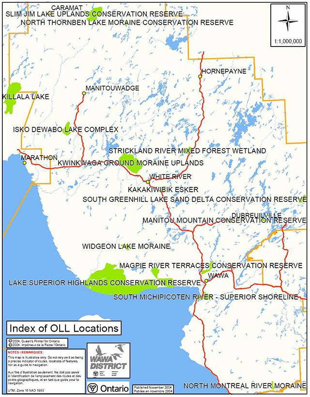
8.3 Location map
8.4 Procedural Guideline B – Land Uses – Test of Compatibility (PL Procedure 3.03.05)
The Conservation Reserve policy provides broad direction with regard to the permitted uses. The policy provides only an indication of the variety of uses that will be considered acceptable in conservation reserves. The only caution is that "any new uses, and commercial activities associated with them, will be considered on a case by case basis, and, they must pass a test of compatibility to be acceptable."
What does a 'test of compatibility' mean?
An examination of this must start from the premise of why an area is set aside – specifically, its representative natural heritage values. Criteria are then identified to guide compatibility considerations. These criteria apply to the long-term acceptability of both existing uses and new uses.
-
Conformity to SCI/RMP: SCI describe values for which an area has been set aside and the range of appropriate uses that will be permitted in the area. SCI may also speak to the acceptability of other 'new' uses currently not occurring in the area.
The first 'test' is: "do proposed new land uses and/or commercial activities conform to the direction of the SCI/RMP for the conservation reserve? Would the new use(s) depart from the spirit of appropriate indicator land uses in the SCI/RMP?"
- Impact Assessment: If the proposed use(s) pass test 1 it is important to determine their impact on the area before they are approved. This should include the following:
- Impact on natural heritage values: "will the new use(s) impact any natural values in the area? If so how and to what degree? Is it tolerable?"
- Impact on cultural values: "will the new use(s) impact an historical or archaeological values in the area?"
- Impact on research activities: "will the new use(s) affect research activities in the area?"
- Impact on current uses: "will the new use(s) have any negative impact on the array of current uses?"
- Impact on area administration: "will the new use(s) increase administrative costs and/or complexity?" (For example, the cost of area monitoring, security and enforcement).
- Impact on accommodating the use outside the conservation reserve: "Could the use(s) be accommodated as well or better outside the conservation reserve?"
- Impact on socio-economics of the area: "will the new use(s) affect the community(ies) surrounding the area in a positive or negative way?" (For example, will the new use make an area less remote thereby affecting a local tourism industry that is dependent on the area’s remoteness for its appeal?"
- Impact on area accessibility: "does the new use(s) give someone exclusive rights to the area or a portion of the area to the exclusion of other existing uses?"
8.5 Summary of permitted land and resource uses
| Use | Permitted | Permitted |
|---|---|---|
| Commercial timber harvest, commercial hydro development | No | No |
| Mineral exploration and mining | No | No |
| Bait fishing, commercial fur harvesting | Maybe | Yes |
| Sport hunting | Yes | Yes |
| Sport fishing | Yes | Yes |
| Seasonal recreation camps ("hunt camps") | No | Yes |
| Commercial bear hunting | No | Yes |
| Tourism Facilities (for resource based tourism) and recreational trails | Maybe | Yes |
| Land Disposition | Maybe | No |
| Roads | No | Yes |
| Energy Transmission and Communications Corridors | No | Yes |
| Commercial Food Harvesting | No | No |
| ATV and Snowmobile use on trails | Maybe | Yes |