Winisk River Provincial Park Management Statement
This document provides policy direction for the protection, development and management of Winisk River Provincial Park and its resources.
Regional Director’s Approval Statement
Winisk River Provincial Park
This revised Interim Management Statement will provide interim direction for the management of the above Provincial Park until a comprehensive Park Management Plan is prepared.
This statement will provide the basis for the subsequent preparation of the Park Management Plan.
I am pleased to approve this Interim Management Statement.
M. S. Millar
A/Regional Director
North Central Region
Revised: March 1991
Background information
Date: 1969
- Name: Winisk River
- Proposed class: Waterway
- MNR district: Geraldton
- MNR region: North Central
- Total Area (ha): 152,500
Land: [no information provided]
Water: [no information provided] - Site Region: 2W
- Site District: 3
- Date in regulation: 1969
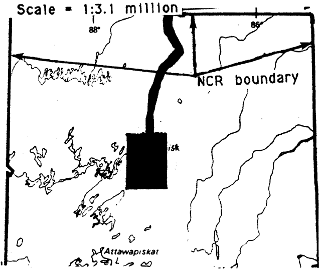
Enlarge figure 1: Regional setting (PDF)
Targets
1. Life science representation
- site type/landscape unit: Portions of Hudson Bay Lowlands, Winisk Drumlin Field and Cochrane Advance Landscape Units.
- species/communities: [no information provided]
2. Earth science representation
- geological theme:
- Island Arcs and Basins Environmental Theme
- Timiskaming Interstadial
- Driftwood Stadial
- feature:
- Sachigo Subprovince
- Big Beaverhouse Moraine
- Winisk Drumlin Field
- Cochrane Advance features
3. Cultural resource representation
- theme: Unknown but high potential for sites (see Riddle, 1982).
- theme segment: [no information provided]
4. Recreation opportunities
- day use: N/A
- car camping: N/A
- wilderness/back country: 1,800
Inventories
| Level/type | Reconnaissance completion date | Detailed completion date | Required? |
|---|---|---|---|
| Earth science | checksheet, April 1979 | [no information provided] | detailed inventory |
| Life science | [no information provided] | [no information provided] | [no information provided] |
| Cultural | [no information provided] | [no information provided] | detailed inventory |
| Recreational | [no information provided] | [no information provided] | [no information provided] |
Winisk River Provincial Park Interim Management Statement
I Land tenure
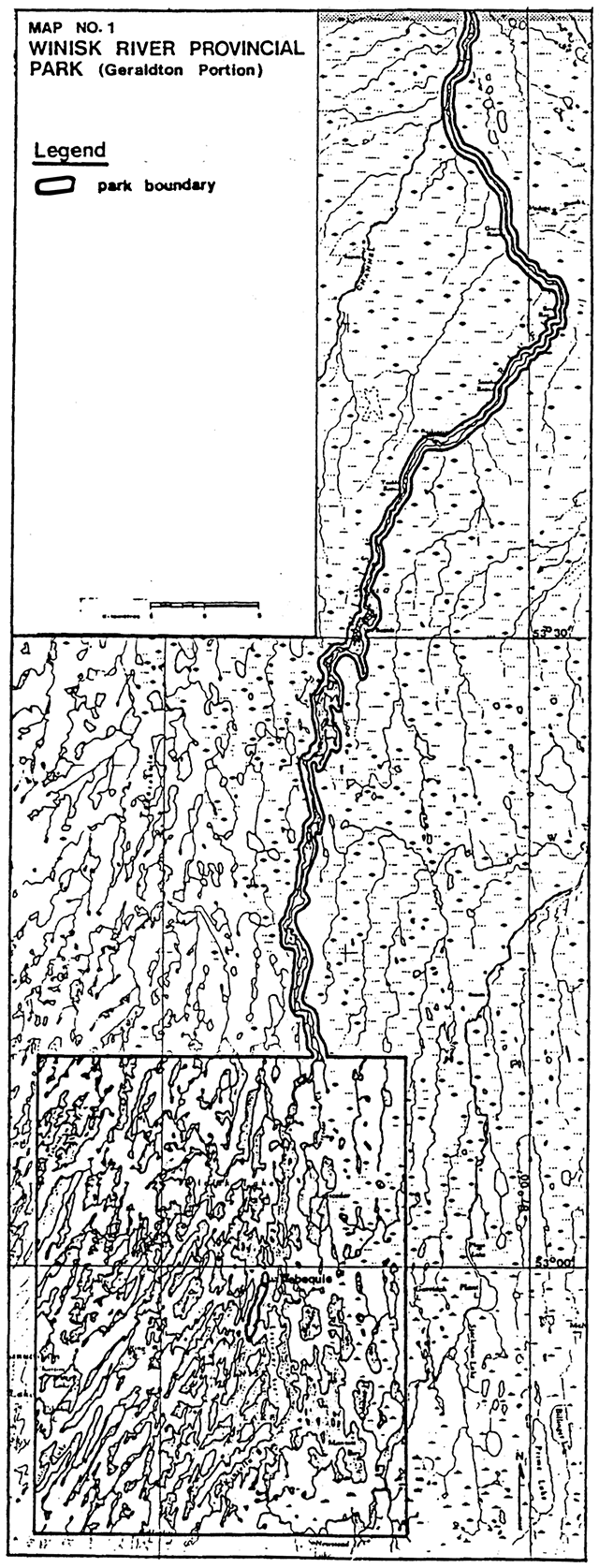
In October of 1966, the area surrounding the settlement of Webequie was set aside as the “Winisk Wild River Indian Guide Territory.” The Winisk Wild River Park was established by Regulation in 1968. The community of Webequie, including the Ministry of Transportation airstrip located on the northern end of Eastwood Island, was withdrawn from the Park in 1978 (see Map No.1). The description of the Park boundary is included in Appendix A.
Land use permits were first issued for five sites in the Park in 1973, but previous to this, these sites were operated as commercial tourist establishments under a letter of authority from the Ministry. East site occupies about 0.4 hectares today.
Guideline
Annual renewal of the land use permits will occur until a Management Plan is completed.
Requests from the community of Webequie for additional land area for community purposes or development will be assessed at the time they are received and all Ministry policies and procedures will be followed.
No further land alienation will occur within the Park until a Management Plan is prepared.
II Land acquisition/disposition
N/A
III Existing/proposed development
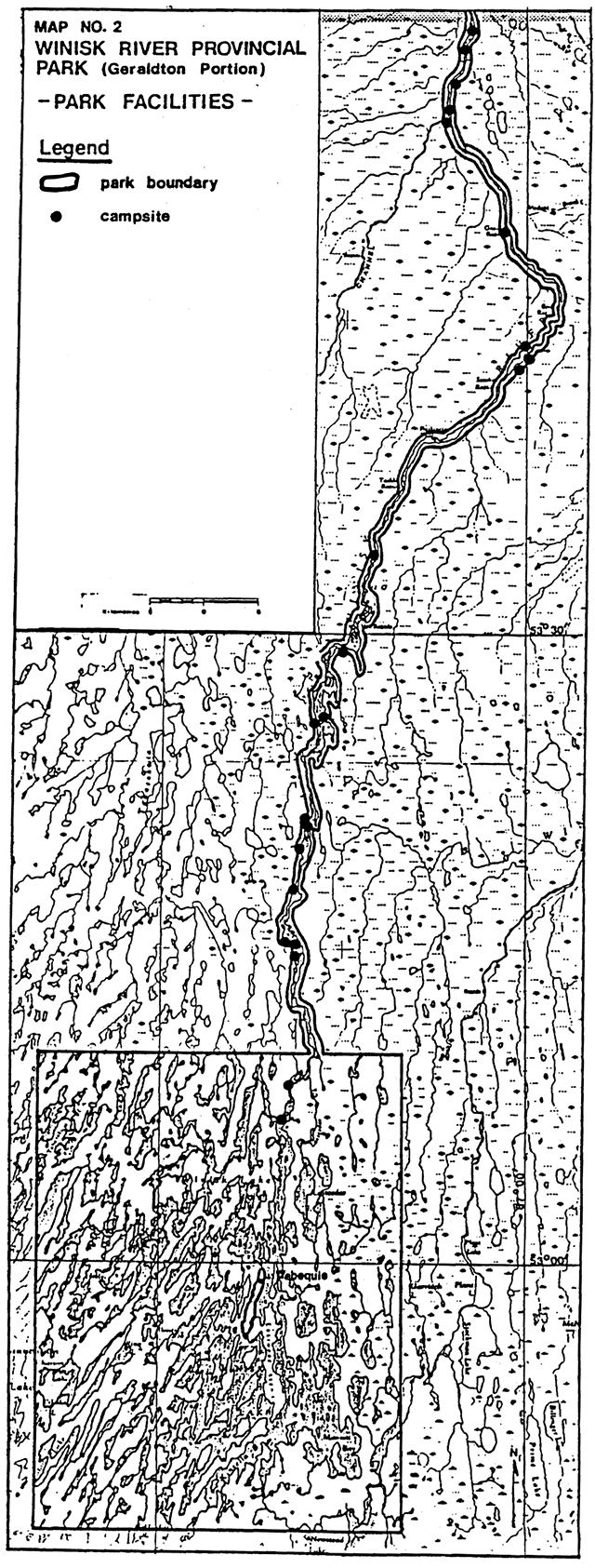
The only access to Winisk River Provincial Park is by canoe, by air, to the airport at Webequie, or by float plane. Canoe trips generally start at Webequie. The map of the canoe route identifies at least 22 campsites in the Geraldton portion of the Park (see Map No.2). During July, 1978, M.N.R. funded the school teacher at Webequie to update the canoe route information, clean some of the campsites and brush some of the portages. Since that time, no additional work has been done on the Park and the present condition of the facilities is unknown.
During the District Land Use Planning process, several options to change the Park boundary were identified. The intent was to alter the existing boundary to include additional areas that would increase the earth and life science representation. The two proposed Nature Reserve zones, Tabasokwia River and Last Cedar Creek, were designated as Areas of Natural and Scientific Interest and the decision on the boundary change was deferred pending further investigation of these areas. These options are shown in Appendix D.
Guideline
Geraldton District will explore various options for the maintenance of the remote Park. Some of the options under consideration include: 1) hiring and training some of the local residents of Webequie for the job; or 2) funding a crew that would work out of Geraldton.
The existing Park boundary will remain until a thorough investigation of the proposed changes is completed.
IV Recreation activities
The primary recreational activities in the Winisk River Provincial Park are canoeing, sport fishing and hunting. In addition, the residents of Webequie partake in swimming, recreational boating, camping, berry picking and snowmobiling. Trips down the river to the community of Winisk Peawanuck are common. Outboard motors are commonly used.
Guideline
Sport fishing will continue to be permitted in the Park, except where fish sanctuaries are established.
Hunting has been, and will continue to be permitted in the Park. This policy may change through normal Park Management Planning/Review processes, with public involvement.
Mechanized travel will be decided during Park Management planning.
The use of the Park area by the residents of Webequie for recreation will continue.
Use of the Park for high quality recreational activities, such as sport fishing and remote canoeing, will be encouraged in order to attract users to the area.
V Commercial activities
Commercial tourism
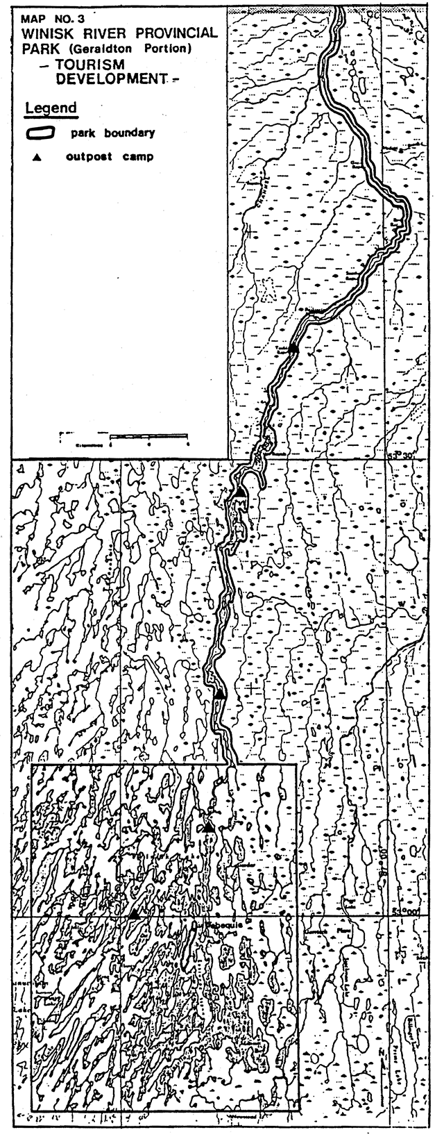
There are five outpost camps along the Park waterway which are operated by Winisk River Camps from the community of Webequie (see Map No.3). They cater to sport fishermen and hunters. Guests fly to Webequie then proceed down the river, utilizing each outpost camp for accommodations along the way, or to camp locations along the river (see Appendix B).
The Band Council also provides an outfitting and guide service for parties that wish to travel the Park. The level of use of both of these commercial activities is not known.
Guideline
Commercial tourism will be permitted in the Park subject to the pending Management Plan.
No additional tourism development will be permitted pending completion of a Management Plan.
Existing structures may be reconstructed providing there is no increase in camp capacity. Additional accessory structures like docks or ice houses may be built.
The camps may only be transferred to another native resident of Webequie.
Aircraft landings will be permitted within the entire Park area, subject to the Management Plan.
Trapping
Portions of 7 traplines are located within Winisk River Provincial Park. They are all operated by the people of Webequie. There is no inventory of trapline cabins in the Park area.
Guideline
Trapping is permitted within the Park only by Status Indians enjoying treaty rights.
Existing trapline cabins are permitted but new developments will be encouraged to locate outside of the Park.
Transfers of existing traplines inside the Park will only be allowed between or to Status Indians. Transfers of traplines must be approved by the Ministry.
Only Status Indian trapper helpers are permitted to assist Status Indian trappers.
No new traplines will be established in the Park.
Where a trapper’s licence lapses, the licence will not be renewed.
Commercial fishing
Winisk Lake is licenced for commercial fishing. Existing quotas are: yellow pickerel (26,352 kg); whitefish (19,764 kg); and northern pike (20,587 kg). Little fishing has been done in recent years.
Guideline
Commercial fishing and commercial bait fishing will be permitted in the Park in the interim, until addressed in the Management Plan.
Quotas will be based on the best biological information available. Greater use of the resource will be encouraged.
Where licences lapse they will not be renewed.
No new licences will be issued for the Park.
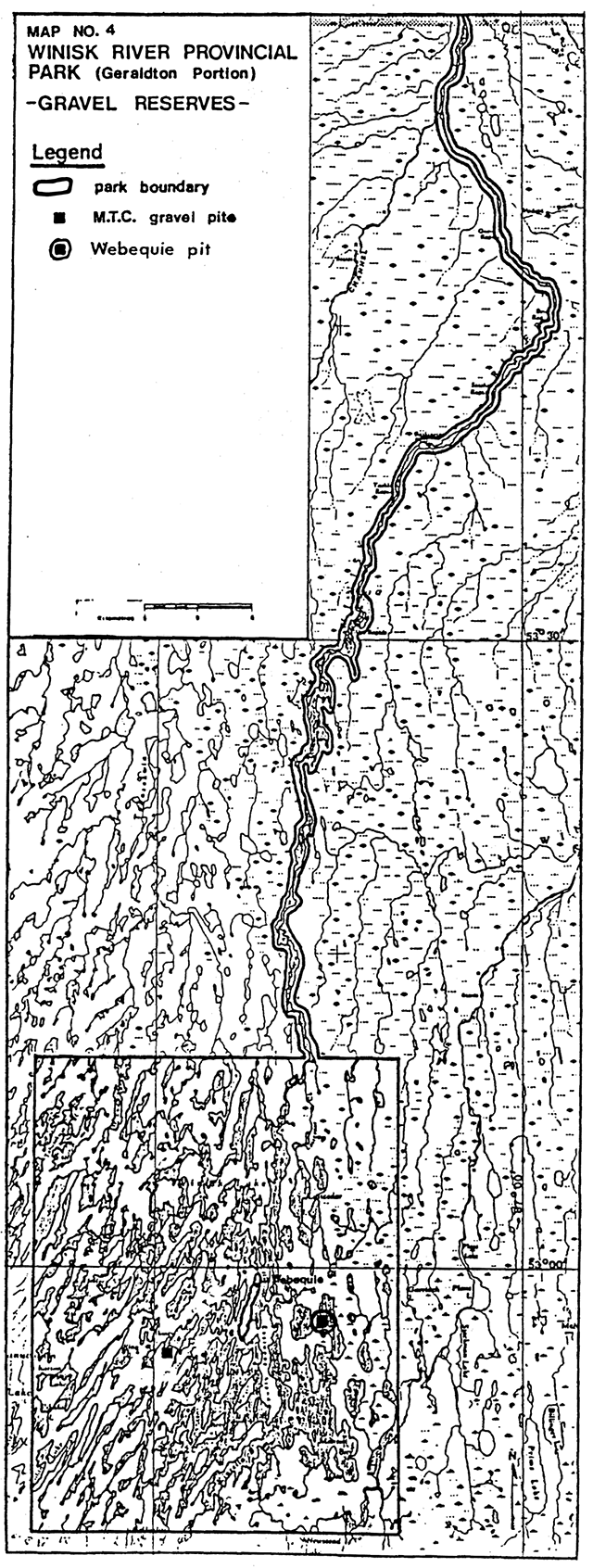
Mineral resources
The Park area is withdrawn from staking. There are two gravel pits in the Park. One is located southwest of Webequie held by Ministry of Transportation for airport maintenance; aggregate pit is valid until April 27, 1994. The other gravel pit is held by the Webequie Band and located east of the community. It is used for community projects and presently renewed annually (see Map No. 4).
Guideline
New mining activity, including prospecting, staking of mining claims or development of mines will not be permitted in the Park.
Aggregate extraction will occur in order to maintain the airstrip and to meet community needs. All aggregate will come from the existing aggregate pits. Should additional sources be required, prospective areas will not be endangered, before a gravel pit is established.
Restrictions will be placed on quarry and work permits to protect Park values.
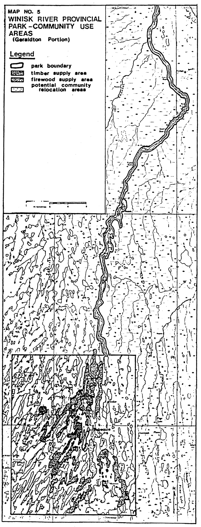
Timber
The trees in this area have little commercial value, but are of importance to the community for both firewood and materials. Map No. 5 delineates the community wood supply areas.
The actual volume of wood utilized each year is not known, but the level of use is thought to be minimal. In addition, the harvesting methods used have little impact on the environment and aesthetics of the Park.
Guideline
Timber harvesting for firewood and sawmill logs will be permitted to continue.
Native interests
For a number of years the community of Webequie has been seeking reserve status. Legally, they are associated with the Fort Hope Band, but administratively, they are a separate entity. Negotiations for reserve status have been ongoing.
Guideline
If the question of reserve status is resolved, the agreed upon land area would be withdrawn from the Park.
Any request for additional area for the community will be assessed at the time. Any land area that is granted for such a request will be withdrawn from the Park. Any land area that is no longer required by the Band may be incorporated back into the Park.
Environmental assessment and Ministry deregulation procedures for any change to the area of the Park, will be followed.
Status Indians enjoying treaty rights to carry on traditional natural resources harvesting activities shall be permitted to carry on those activities in accordance with the terms of their treaty within provincial parks situated within their treaty areas. Accordingly such Status Indians will be permitted to carry on those activities in certain circumstances. The details of those circumstances will be the subject of further discussion and review.
Decisions on relocation, expansion of existing Status Indian owned commercial hunt camps, and decisions on the development of new commercial hunt camps within a Park will be determined through Park Management planning.
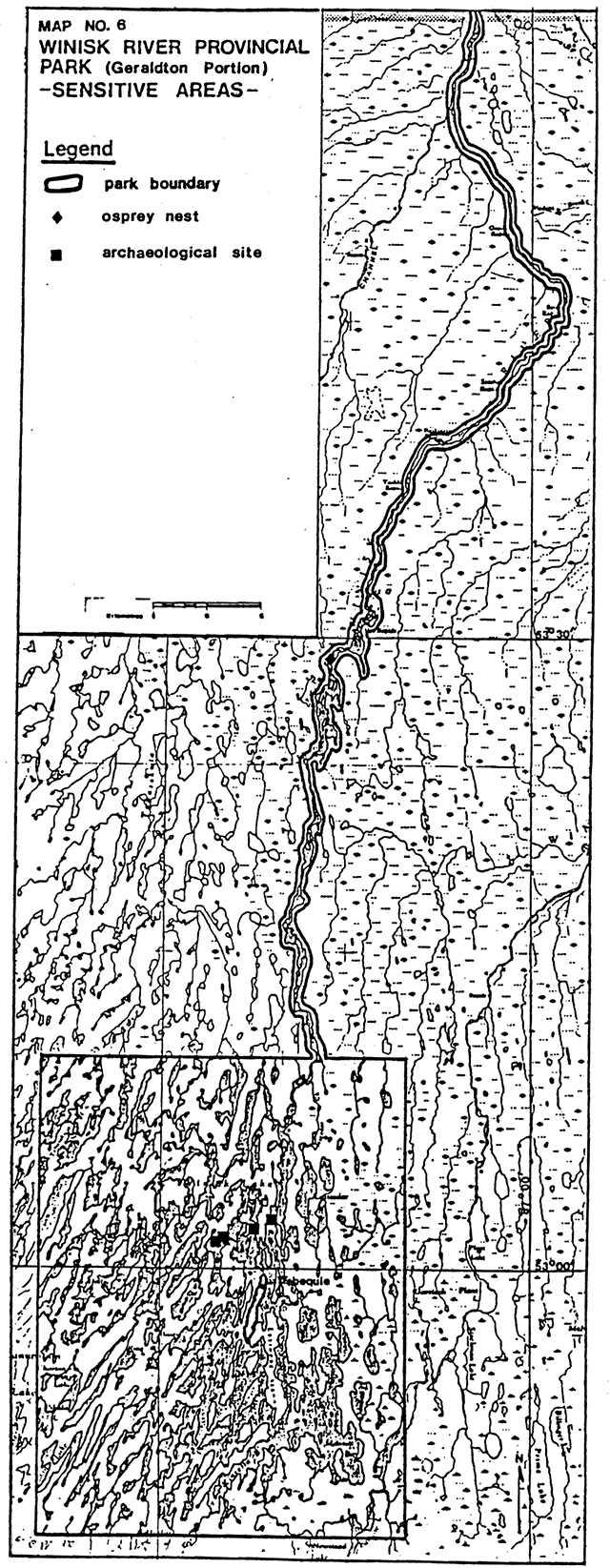
VI - V Natural/cultural resources
One osprey nest has been identified along the Park waterway. In addition, the river has a sensitive speckled trout population of interest to sport fishermen.
An archaeological survey was started in 1980 but had to be terminated before it was completed. Four sites have been identified (see Map No. 6).
Guideline
Sensitive areas will be recorded and appropriately managed as they are identified.
The speckled trout population is an important resource in Winisk River Provincial Park. Special management techniques such as reduced creel limits, regulated fishing pressure and stocking are options that may be considered. Discussions will be carried out with all interested parties, including the residents of Webequie.
Fire
Guideline
Fires occurring within the Park will be managed according to the Regional Fire Management Policy.
Use of the Park for access to a fire will require the approval of the District Manager.
VIII Client services
The Geraldton District Office handles all public inquiries concerning the Winisk River Provincial Park. A series of maps at a scale of 1 inch equals 1 mile is available to interested canoeists. There is also a canoe route description available to the public.
A questionnaire is sent out with each reply to a public request for information, but very few are returned. Most people do not realize the costs and difficulty involved in reaching Park. Consequently, there is no reliable estimate of Park use, but it is to be very light.
At the present time, there are no Park staff hired or user fees collected.
Guideline
A survey of the Park to determine the condition of portages and campsites, and the extent of the garbage problem (which some people indicated is quite bad) will be carried out. Geraldton District will investigate the various options for achieving this end.
A new canoe route brochure will be prepared based on this new information.
An information system to determine the actual level of use will be established in cooperation with Moosonee District. This will be an important step for the Management Planning exercise.
IX Research/inventories
N/A
References/sources
Geraldton District Land Use Guidelines (unreleased). 1984. Ontario Ministry of Natural Resources.
Park Impact Assessment Sheet, Winisk River Provincial Park.
Ontario Ministry of Citizenship and Culture. Studies in West Patricia Archaeology, Number 3/1980-81. Research Report No. 19. Edited by W. A. Ross, Archaeology and Heritage Branch. 1982.
Winisk River Canoe Route Maps. Scale 1" = 1 mile.
Winisk River Canoe Route Brochure.
Ontario Gazette, Ontario Regulation 145/78, s.1. 1978.
Ontario Ministry of Natural Resources Map No’s: G-203, G-242, G-247, G-249, G-257, G-270, G-294, G-301, G-302, G-334, G-339, G-380, G-416, G-423, G-424, G-42S. Scale 1"=40 chains. 1984.
Ontario Ministry of Natural Resources Trapline Map, Commercial Tourism Map. Scale 1:250,000. 1984.
Ontario Ministry of Natural Resources. Geraldton District Fisheries Management Plan (draft). Geraldton District. 1983.
Martin, Stuart C. Report on the Winisk River from Webequie in Winisk Wilderness Provincial Park to Hudson Bay (unpublished). July 1978.
Community of Webequie Land Use Proposal (hand drawn maps). December 1981.
Geraldton District Office Files. 1984
Winisk River management area Maps
Enlarge Winisk River management area Map No. 1 (PDF)
Enlarge Winisk River management area Map No. 2 (PDF)
Enlarge Winisk River management area Map No. 3 (PDF)
Enlarge Winisk River management area Map No. 4 (PDF)
Enlarge Winisk River management area Map No. 5 (PDF)
Enlarge Winisk River management area Map No. 6 (PDF)
Appendix A: Winisk Waterway Park boundary description
Schedule 75
Winisk River Provincial Park
In the Territorial District of Kenora, Patricia Portion containing an area of 670 square miles, more or less, and described as follows:
Beginning at the intersection of longitude 87° 40' with latitude 52° 47'; thence northerly along longitude 87° 40' a distance of 26.5 miles, more or less to latitude 53° 10'; thence easterly along latitude 53° 10' to a point distance 400 feet measured westerly from and perpendicularly to the high water mark along the westerly bank of the Winisk River: thence in a northeasterly, northerly, easterly and northeasterly direction parallel to the said high water mark and 400 feet in perpendicular distance therefrom to latitude 55° 14'; thence easterly along that latitude to a point distant 400 feet measured easterly from and perpendicularly to the high water mark along the easterly bank of the Winisk River; thence in a southwesterly, westerly southerly and southwesterly direction parallel to the said high water mark and 400 feet in perpendicular distance therefrom to latitude 53° 10'; thence easterly along 53° 10' to longitude 87° 10'; thence southerly along longitude 87° 10' a distance of 26.5 miles, more or less, to latitude 52°47'; thence westerly along latitude 52°47' a distance of 20.8 miles, more or less, to the place of beginning.
Excepting and reserving therefrom that part of the Winisk Indian Reserve No. 90 situated at the junction of the Asheweig River and the Winisk River.
Also exception therefrom the northwesterly arm of Eastwood Island in Winisk Lake described as follows:
Beginning at the intersection of latitude 52°57' with longitude 87°22'13"; thence south 30° west 2,300 feet more or less to the water’s edge of Winisk Lake; thence in a general northeasterly, easterly and southwesterly direction along that water’s edge to the place of beginning. O.Reg. 145/78, s.1.