Stormwater Management Planning and Design Manual
The manual provides technical and procedural guidance for planning, design and review of stormwater management practices, including guidance for stormwater management sewage works approvals under Section 53 of the Ontario Water Resources Act.
March 2003
Cette publication technique n'est disponible qu'en anglais.
Copyright: Queen’s Printer for Ontario, 2003
This publication may be reproduced for non-commercial purposes with appropriate attribution.
ISBN 0-7794-2969-9
PIBS 4329e
Preface
The "state-of-the-art" of stormwater management has been rapidly evolving and this manual is one step in this evolutionary process. The manual provides technical and procedural guidance for the planning, design, and review of stormwater management practices. It is important that the manual be viewed as a tool for understanding the performance requirements of stormwater management projects and not as a rulebook for all stormwater management solutions.
The manual provides practical guidance which has been found effective in specific circumstances. However, users must exercise judgement and flexibly adapt the guidance provided. Stormwater management solutions need to consider specific site conditions and this must be recognized when applying the guidance provided in the manual.
It is not the intent of the Ministry to limit innovation with the manual. Significant effort has been made to write the manual in a manner that does not inadvertently restrict creative solutions. The Ministry encourages the development of innovative designs and technologies. Where the designer can show that alternate approaches can produce the desired results or even better, such designs should be considered. However, the designer is responsible for the designs which are made with respect to stormwater management for any given site. This manual should be used in conjunction with other established manuals and practices. It updates the Stormwater Management Practices Planning and Design Manual (June 1994).
This manual will also be used as a baseline reference document in the review of stormwater management applications for approval under section 53 of the Ontario Water Resources Act as administered by the Ministry of the Environment.
Acknowledgements
This project was initiated and funded by the Ontario Ministry of the Environment. It was also funded and supported by the Government of Canada’s Great Lakes Sustainability Fund (GLSF), Credit Valley Conservation, and the Toronto and Region Conservation Authority. The following agencies and staff participated on the steering committee.
Ontario Ministry of the Environment (MOE):
- Jonathan P'ng (Project Officer)
- Dale Henry
- Ljuba Simovic
- Stewart Thornley
Credit Valley Conservation (CVC):
- Hazel Breton
Great Lakes Sustainability Fund (GLSF):
- Sandra Kok
Toronto and Region Conservation Authority (TRCA):
- Glenn MacMillan
Conservation Ontario:
- Represented by CVC and TRCA
Department of Fisheries and Oceans:
- Wayne Hyatt
- Christine Stoneman
Ontario Ministry of Natural Resources (MNR):
- Les Pataky
Ontario Ministry of Transportation (MTO):
- Hani Farghaly
- William Snodgrass
Municipal Engineers Association (MEA):
- Jeff Smylie
National Water Research Institute:
- Jiri Marsalek
Editing and technical review of the manual was done by Andrea Bradford and Cristina Giannetas (MOE). Helpful guidance was provided by Phyllis Miller and Hardy Wong of MOE. Dale Taylor and Scott Macleod of the Ministry of Municipal Affairs and Housing (MMAH) provided comments on Chapter 5. Other stakeholders participated in the workshops and provided input into the development of the manual.
The consultants for the project were Aquafor Beech Ltd. (Dave Maunder) and Marshall Macklin Monaghan Ltd. (Doug Andrews) in association with the Centre for Watershed Protection and Environmental Water Resources Group.
Executive summary
Stormwater management is required to mitigate the effects of urbanization on the hydrologic cycle including increased runoff, and decreased infiltration, of rain and snowmelt. Without proper stormwater management, reduced baseflow, degradation of water quality, and increased flooding and erosion can lead to reduced diversity of aquatic life, fewer opportunities for human uses of water resources, and loss of property and human life.
Watershed planning integrates environmental and land use planning. Criteria for the protection of water quantity, water quality, habitat, and biota are established to help achieve the goals set for the watershed. Strategies to manage human activities within the watershed are developed to meet protection criteria. A stormwater management strategy may include protection of natural areas, design of communities to reduce stormwater generation, and pollution prevention programs, as well as the stormwater management practices which are the focus of this technical manual.
A combination of lot level, conveyance, and end-of-pipe stormwater management practices are usually required to meet the multiple objectives of stormwater management: maintaining the hydrologic cycle, protection of water quality, and preventing increased erosion and flooding. Lot level and conveyance controls may be classified as storage or infiltration controls. Storage controls are designed to detain stormwater. Although the volume of runoff does not decrease, the risk of flooding is reduced because all the stormwater runoff does not arrive at the stream at the same time. Infiltration controls are necessary for soil moisture replenishment and groundwater recharge. They can achieve water quality enhancement but are ideally suited for infiltration of relatively clean stormwater including rooftop and foundation drainage. Pre-treatment of road drainage is necessary to prevent clogging of a system and to protect groundwater quality.
End-of-pipe stormwater management practices must control the effects of urbanization which remain after preventative techniques and lot level and conveyance measures have been applied. End-of-pipe facilities are usually required for flood and erosion control and water quality improvement, although lot level and conveyance controls can reduce the size of the end-of-pipe facilities required.
Design guidance is provided for individual lot level, conveyance, and end-of-pipe practices. It includes physical constraints to the use of the practices, such as, soil type and depth to groundwater; sizing and configuration; and design details which vary considerably but which may include inlets and outlets, filter media, and distribution pipes. The guidance also includes cold climate considerations and the incorporation of vegetation in design.
Proper maintenance is critical to the successful performance of a stormwater management system. During the first two years of operation, inspections after significant storms will ensure that the system is functioning properly. After this, annual checks may be done to identify maintenance needs. Blockages may need to be cleared from inlets and outlets. Unhealthy vegetation may need to be tended or replaced. The design of stormwater management practices for water quality improvement is based primarily on settling of sediment. Therefore, at some point, accumulated material will need to be removed.
A preferred stormwater management system will be selected based on its cost, as well as other factors such as technical feasibility, effectiveness, and social acceptability. The overall cost must include capital, operating, and maintenance costs. Information provided may be used for preliminary estimates of cost. However, refinement of estimates to reflect site-specific considerations will be required.
Introduction (1.0)
1.1 History of manual
In June 1991, the Ministry of the Environment published a report entitled Stormwater Quality Best Management Practices. The report documented experience with structural and non-structural Stormwater Management Practices (SWMPs) and concluded that they should be implemented in conjunction with new urban development and redevelopment.
Guidance, and a procedure for selecting appropriate SWMP types, was provided. The report stated, however, that "integrated watershed planning is the preferred means of defining uses of the receiver and hence the basis for SWMP selection." Recognition of the importance of watershed and subwatershed-based planning has continued to grow since the release of the 1991 study.
The Ministry of the Environment initiated the development of a Stormwater Management Practices Planning and Design Manual which was published in June 1994. Stormwater management has evolved considerably in Ontario since 1994; therefore, the Ontario Ministry of the Environment together with the Government of Canada’s Great Lakes Sustainability Fund, Credit Valley Conservation, and other agencies undertook a project to update the manual. Furthermore, the 1994 manual focused more on water quality and there was an interest by various parties to produce a more integrated approach that incorporated water quantity and erosion considerations. This manual provides further development and update of key components.
Regarding the intended use of this document, it is worth emphasizing points made in the preface.
The "state-of-the-art" of stormwater management has been rapidly evolving and this manual is one step in this evolutionary process. The manual provides technical and procedural guidance for the planning, design, and review of stormwater management practices. It is important that the manual be viewed as a tool for understanding the performance requirements of stormwater management projects and not as a rulebook for all stormwater management solutions.
The manual provides practical guidance which has been found effective in specific circumstances. However, users must exercise judgement and flexibly adapt the guidance provided. Stormwater management solutions need to consider specific site conditions and this must be recognized when applying the guidance provided in the manual.
It is not the intent of the Ministry to limit innovation with the manual. Significant effort has been made to write the manual in a manner that does not inadvertently restrict creative solutions. The Ministry encourages the development of innovative designs and technologies. Where the designer can show that alternate approaches can produce the desired results or even better, such designs should be considered. However, the designer is responsible for the designs which are made with respect to stormwater management for any given site. This manual should be used in conjunction with other established manuals and practices. It updates the Stormwater Management Practices Planning and Design Manual (June 1994).
This manual will also be used as a baseline reference document in the review of stormwater management applications for approval under section 53 of the Ontario Water Resources Act as administered by the Ministry of the Environment.
Changes incorporated in the 2003 Manual were based on feedback received from a variety of sources including: a User’s Survey given to individuals who obtained the 1994 Manual or attended a seminar in 1994; a questionnaire, circulated in 1997 to provincial agencies, conservation authorities, municipalities and other storm water management professionals; and, two workshops. A Steering Committee, comprised of stakeholders from a variety of agencies, reviewed material and provided input and direction throughout the development of the manual.
The key components (topics) which have been added, expanded, or updated in this manual include:
- providing an overview of the impacts of urbanization on the hydrologic cycle andstream ecosystems;
- addressing the evolution of the watershed planning process and implications for the design process;
- incorporating water quantity, erosion control, water quality protection, and water balance principles into the selection and design of Stormwater Management Practices (SWMPs);
- documenting the performance of SWMPs that have been monitored;
- incorporating design considerations for cold climate conditions for SWMPs;
- providing information on SWMPs such as sand filters, bioretention filters, wet swales and hybrid wet ponds/wetlands;
- writing a chapter on infill projects;
- updating the operation and maintenance chapter;
- providing design examples for SWMPs;
- updating material relating to planting strategies and the function of plant material in the design of SWMPs;
- providing an appendix on assessment methodology for retrofitting SWMPs together with an example; and
- providing an appendix which deals with integrated planning for stormwater management.
Further consultation with stakeholders took place through the posting of a revised draft on the Environmental Bill of Rights registry in 1999-2000. The final manual reflects the changes made as a result of the comments received.
There will be a transition period in which the guidance in the new manual will begin to be applied. Reasonable efforts should be taken to minimize any disruption to on-going projects during the transition period.
1.2 Manual outline
Provided below is a brief overview of each chapter, as well as the key components that have been added to this version.
Chapter 1 – Introduction
Provides an introduction to the Manual, outlining its history and topics which have been introduced, further developed, or updated, as well as a brief overview of the contents within each chapter. Also provided is an introduction to the potential impacts of urbanization on hydrological aspects of the natural environment.
Chapter 2 – Environmental Planning
Describes the environmental planning process and its relationship with the municipal land use planning and approval process. It describes the types of environmental planning studies that may be undertaken, the deliverables provided by each study, and methods for integrating planning for stormwater management. It also notes that if there are insufficient environmental studies completed to define environmental conditions to set environmental goals/objectives and targets, and to provide a basis for selection and design of SWMPs, additional work (Chapter 3) will be required prior to the initiation of the design process (Chapter 4).
Chapter 3 – Environmental Design Criteria
Presents general environmental design criteria to be used in lieu of criteria that would normally be available from the environmental planning process. Information outlining the required areas of consideration is provided, as is guidance which should be used in order to identify potential problems and provide a reasonable level of impact mitigation. Criteria are presented for water balance, water quality, erosion control/geomorphology, and water quantity.
Chapter 4 – Stormwater Management Plan and SWMP Design
Provides design guidance on SWMPs. The guidance has been updated to reflect recent experience and supplemented where new techniques are available. Quantity control SWMPs have been added. The SWMPs have been grouped as lot level and conveyance controls and end-of-pipe controls. New SWMPs introduced include storage controls, wet swales, hybrid wet pond/wetlands, perimeter sand filters, and bioretention filters.
Chapter 5 – Infill Development
Discusses the challenge of applying stormwater management practices for small, infill sites within developed areas. Approaches and techniques are discussed, including use of off-site systems as an alternative.
Chapter 6 – Operation, Maintenance, and Monitoring
Topics include the need for maintenance, the tasks to be completed, as well as the frequency with which the activities should be undertaken. This advice remains essentially as provided in the 1994 manual although information on vegetation (natural succession) and hard-bottom forebays has been updated.
Chapter 7 – Capital and Operational Costs
Remains largely unchanged from the advice provided in the 1994 Manual. Costs have been updated.
Chapter 8 – References
1.3 Hydrological effects of urban development and their impacts on ecosystems
Hydrologic cycle
The hydrologic cycle describes the continuous circulation of water between the oceans, atmosphere, and land. Water is supplied to the atmosphere by evapotranspiration, which includes evaporation from all water, snow, vegetation, and other surfaces, plus transpiration from plants. It is returned to the land through precipitation. Within the hydrologic cycle, water may be stored by vegetation, snowpacks, land surfaces, water bodies, saturated subsurface zones, and unsaturated subsurface zones/soils. Water may be transported between these storages via overland runoff, streamflow, infiltration, groundwater recharge, and groundwater flow, among other processes (Figure 1.1).
Humans interact with the hydrologic cycle by extracting water for agricultural, domestic, and industrial uses, and returning it as wastewater discharges. Urban development may also interfere with the natural transfers of water between storage components of the hydrologic cycle.
For any system with defined boundaries (e.g., a watershed), a water balance may be used to describe the hydrological cycle. More specifically, the water balance provides for an accounting of water transfers across the system’s boundaries over some time period. Any difference between inflows to the system and outflows from the system during this time period must be balanced by a change of storage within the system.
Changes to the hydrologic cycle/water balance
A major consequence of the increase in impervious area which accompanies urbanization is an increase in direct runoff and a corresponding decrease in infiltration. Table 1.1 (WEF, 1998) illustrates the changes in hydrological components that result from developing a forested area. Urbanization also results in decreased evapotranspiration. The net effect of conventional development practices on an urban stream is a dramatic change in the hydrologic regime of the stream.
Effects include:
- an increase in the magnitude and frequency of runoff events of all sizes;
- delivery of more of the stream’s annual flow as surface storm runoff rather than base flow or interflow; and
- increases in velocity of flow during storms.
The decrease in infiltration that occurs with urbanization reduces soil moisture replenishment and groundwater recharge. In Ontario, a significant proportion of domestic and agricultural water supplies are from a groundwater source. Groundwater is also the source of stream baseflow which is important for sustaining aquatic life.
Figure 1.1: Hydrological Cycle:
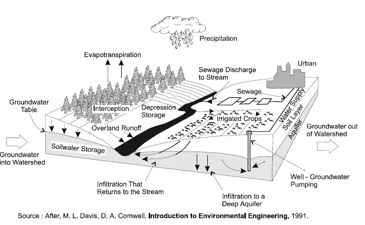
Definitions:
- Overland runoff
- water that travels over the ground surface to a channel
- Streamflow
- movement of water via channels
- Groundwater flow
- movement of water through the subsurface
- Infiltration
- penetration of water through the ground surface
- Groundwater recharge
- water that reaches saturated zone
The preservation of the natural hydrologic cycle, to the greatest extent possible, will not only maintain groundwater recharge so as to reduce baseflow impacts, but it will reduce the potential for flooding and erosion, and hence, the size and cost of stormwater infrastructure. Therefore, it is one of the primary goals of stormwater management.
Changes in stream response to storm events
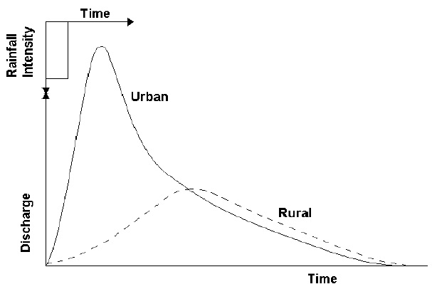
Urban floods differ from those in natural basins in the shape of flood hydrographs (Figure 1.2), peak magnitudes relative to the contributing area, and times of occurrence during the year. The imperviousness of urban areas along with the greater hydraulic efficiency of urban conveyance elements cause increased peak streamflows but also more rapid stream response. Summer floods resulting from high intensity thunderstorms are more common in urban areas. Infiltration and evapotranspiration are much reduced at this time of the year under developed conditions.
The goal of stormwater management is to minimize the risks of loss of life and property damage due to urban floods.
| Item | Forested Areas: Depth(mm) | Forested Areas: % of Total Depth | Urban Areas with 40% Impervious Cover: Depth(mm) | Urban Areas with 40% Impervious Cover: % of Total Depth |
|---|---|---|---|---|
| May to November Rainfall | 515 | 100.0 | 515 | 100 |
| Interception Storage and Depression Storage on Impervious Areas | 342 | 66.5 | 235 | 45 |
| Infiltration | 155 | 30.0 | 100 | 20 |
| Runoff | 18 | 3.5 | 180 | 35 |
Figure 1.2: Flood Hydrographs for Urbanized and Natural Drainage Basins (Watt et al, 1989):
Changes in stream morphology
Stream channels in urban areas respond and adjust to the altered hydrologic regime that accompanies urbanization (WEF, 1998). The severity and extent of stream adjustment is a function of the degree of watershed imperviousness as well as the stream type. Examples of stream adjustments include:
- increased stream cross-sectional area to accommodate higher flows;
- significant downcutting of the stream channel;
- increased sediment loads in the stream because of increased instream erosion as well as watershed inputs;
- modification of the streambed (typically the grain size of channel sediments shifts from coarse-grained particles to a mixture of fine- and coarse-grained particles); and
- changes in characteristics such as location and meander pattern in response to stream crossings by roads and pipelines.
There may also be direct modifications of streams, such as straightening and/or lining, by humans to "improve" drainage and reduce flooding risks.
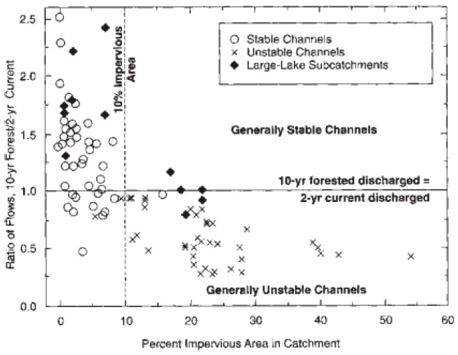
A critical issue is the level of development at which stream morphology begins to change significantly. Research models developed in the Pacific Northwest (U.S.) suggest that a threshold for urban stream stability exists at approximately 10% imperviousness of a watershed (Figure 1.3) (Booth and Reinelt, 1993). Watershed development beyond this threshold consistently results in unstable and eroding channels. The severity and extent of stream adjustment is a function of the magnitude of the change in the sediment-flow regime and the resistance of the channel materials to erosion. The goal of stormwater management is to protect the aquatic ecosystem, as well as the stream’s aesthetic and recreational values, by maintaining a stable fluvial system.
Figure 1.3: Channel Stability as Function of Imperviousness (Booth and Reinelt, 1993):
Changes to water quality
Deterioration of urban stream water quality is associated with two phases of urbanization. During the initial phase of development, an urban stream can receive a significant pulse of sediment eroded from upland construction sites, even if erosion and sediment controls are used. In the second phase of urbanization, the washing off of accumulated deposits from impervious areas during storms becomes the dominant source of contaminants. This manual focuses on mitigation of the effects of the second phase of urbanization. Guideline B-6: Guidelines for Evaluating Construction Activities Impacting on Water Resources (MOE, 1995) provides guidance for mitigation of the effects of construction activities.
Urban stormwater runoff may contain elevated levels of suspended solids, nutrients, bacteria, heavy metals, oil and grease, and pesticides, as well as sodium and chloride from roadsalt. Table 1.2 shows the concentrations of selected constituents of stormwater runoff compared to the Provincial Water Quality Objectives (Aquafor, 1993). Urban runoff may also cause increased water temperatures.
| Parameter | Units | PWQO | Observed Concentrations |
|---|---|---|---|
| Fecal coliforms | CNT/dL | — | 10,000 - 16E6 |
| SS | mg/L | — | 87 - 188 |
| TP | mg/L | 0.03 | 0.3 - 0.7 |
| TKN | mg/L | — | 1.9 - 3 |
| Phenolics | mg/L | 0.001 | 0.014 - 0.019 |
| Al | mg/L | — | 1.2 - 2.5 |
| Fe | mg/L | — | 2.7 - 7.2 |
| Pb | mg/L | 0.025 | 0.038 - 0.055 |
| Ag | mg/L | 0.0001 | 0.002 - 0.005 |
| Cu | mg/L | 0.005 | 0.045 - 0.46 |
| Ni | mg/L | 0.025 | 0.009 - 0.016 |
| Zn | mg/L | 0.030 | 0.14 - 0.26 |
| Cd | mg/L | 0.0002 | 0.001 - 0.024 |
The change in the sediment load of a stream is one of the key factors affecting channel erosion but elevated levels of suspended solids, including both organic and inorganic matter, may have a number of other effects on a receiving water. Increased turbidity interferes with photosynthetic activity by reducing light penetration. Solids in suspension may clog gills and interfere with fish feeding, and the deposition of sediment may cover spawning areas and smother benthic communities. Organic matter exerts an oxygen demand and may severely depress the levels of dissolved oxygen in the receiving water. In addition, several other stormwater contaminants are commonly associated with solids.
The priority of stormwater management with respect to water quality has been control of suspended solids. However, many of the SWMPs can successfully remove other stormwater contaminants as well. Measures that prevent or minimize releases of contaminants that may be carried to streams by stormwater are, of course, preferable to treatment options.
Groundwater quality may also be affected in urban areas, and care must be taken that the stormwater management controls chosen do not contribute to groundwater degradation.
Changes in aquatic habitat and ecology
The ecology of urban streams and other aquatic habitat is shaped and molded by extreme shifts in hydrology, geomorphology and water quality that accompany the development process. Stresses on the aquatic communities of urban streams and other water resources are often manifested as:
- a shift from external (leaf matter) to internal (algal organic matter) stream production;
- a decline in aquatic habitat quality;
- a reduction in diversity in the fish, plant, animal and aquatic insect communities in the stream;
- a loss of sensitive coldwater species;
- a destruction of freshwater wetlands, riparian buffers and springs; and
- a decline in wetland plant and animal community diversity.
1.4 Environmental and municipal land use planning
There is a recognition that a more holistic approach is required to mitigate the impacts of urbanization. This has led to the ecosystem approach for development where environmental planning such as watershed and subwatershed planning is done to provide important information to key decision points in the municipal land use planning process. Chapter 2 describes the typical deliverables from each type of environmental plan such as the watershed plan, subwatershed plan, environmental management plan and the stormwater management plan. The plans should provide direction to proponents of development regarding the impacts of the levels and types of development and the management actions required.
The intent of watershed and subwatershed plans is to prepare goal-oriented strategic plans which will allow urban development to occur while protecting the natural ecosystem functions. Watershed-wide policies or management programs are proposed which are mainly oriented towards conservation and preservation such as agricultural restrictions, buffer strips, salt management, topsoil preservation, wildlife linkages, wetland preservation, natural areas preservation, and forest preservation. Watershed and subwatershed plans look at the cumulative effect of development and do not go down to the level of detail needed for design.
The subwatershed plan evaluates the integrated effect of land use scenarios (development, terrestrial linkages preservation, stream buffer preservation, environmentally sensitive/significant area preservation), and urban SWMPs on objectives related to water balance, stream erosion, water quality, temperature, baseflow, flooding, fisheries habitat and aquatic life. For example, a subwatershed plan may set tributary-based targets for peak flows, baseflow and water quality and specify the aggregate levels of stormwater control. Decisions made at the subwatershed plan have direct bearing on the type of development and acceptable SWMP types and performance level at the stormwater management plan level. The results will govern SWMP selection and design for urban development.
An environmental management plan summarizes the findings of the previous plans and is done on a tributary subcatchment boundary or Secondary Plan boundary or a portion thereof. The smaller scale analysis done for an EMP allows for more refined and specific deliverables than a subwatershed plan. EMPs should be of sufficient detail such that all remaining environmental and/or SWM work may be completed as conditions of the Draft or Site Plan stage. Preliminary SWM designs are done at this stage.
The more detailed SWM plan is prepared at the urban subdivision level to meet the conditions and targets set at the Draft or Site Plan stage. The SWM plan is carried out under private proponency and submitted to the review agencies for comment and approval. The SWM planning is integrated with environmental site planning which includes subdivision planning, site planning and engineering, landscape design, architectural and building design, and local street design. It includes the detailed design of SWMPs.
Subdivision/site planning extends the ecosystem approach from watershed planning to the actual layout of the development. Site planning techniques refer to the layout of development and development standards imposed by the local municipalities. It is a fundamental determinant of the overall change in the hydrologic cycle for a given development. The way a development is planned, and the specific design criteria adopted by the planner or engineer, can have a great impact on the level of success achieved by the stormwater management measures which are implemented.
1.5 Urban stormwater management practices
Table 1.3 introduces the types of stormwater management controls which will be discussed in this manual, and their suitability for mitigating the impacts of urban development. Lot level and conveyance controls include those that are applied at the individual lot level, those which form part of the conveyance system, and controls which may serve multiple lots but are only suitable for small drainage areas (< 2 hectares). End-of-pipe controls receive water from a conveyance system and discharge to a receiving water. They are typically the facilities used to service numerous lots or whole subdivisions.
The term "treatment train" is used to describe the combination of controls usually required in an overall stormwater management strategy to ensure that:
- groundwater and baseflow characteristics are preserved;
- water quality will be protected;
- the watercourse will not undergo undesirable geomorphic change;
- there will not be any increase in flood damage potential; and ultimately
- that an appropriate diversity of aquatic life and opportunities for human uses will be maintained.
Lot level and conveyance controls are required to maintain the natural hydrologic cycle to the greatest extent possible. End-of-pipe facilities are usually required for flood and erosion control and water quality improvement, although lot level and conveyance controls can reduce the size of the end of pipe facilities required.
An overall stormwater management strategy may incorporate broader solutions to stormwater management than the practices described in this manual. These broader solutions may be elements of community design (e.g., reduced pavement width, compact building forms) or preventative measures that can be taken by individuals, businesses, or government agencies (e.g., use of safer alternative products and methods, street cleaning, spill prevention and control).
| SWMP | Water Balance | Water Quality | Erosion | Water Quantity |
|---|---|---|---|---|
| Rooftop storage | F | F | F | M |
| Parking lot storage | F | F | F | M |
| Superpipe storage | F | F | F | M |
| Reduced lot grading | M | • | • | F |
| Roof leader to ponding area | M | • | • | F |
| Roof leader to soakaway pit | M | • | • | F |
| Infiltration trench | M | M | • | F |
| Grassed swales | M | • | • | • |
| Pervious pipes | M | M | • | F |
| Pervious catchbasins | M | • | • | F |
| Vegetated filter strips | M | • | • | F |
| Natural buffer strips | • | • | • | F |
| Rooftop gardens | F | • | • | F |
| SWMP | Water Balance | Water Quality | Erosion | Water Quantity |
|---|---|---|---|---|
| Wet pond | F | M | M | M |
| Artificial Wetland | F | M | M | M |
| Dry pond | F | • | M | M |
| Infiltration basin | • | M | • | F |
| Filters |
F | M | F | F |
| Oil/grit separators |
F | • | F | F |
- M
- High Suitability
- •
- Medium Suitability
- F
- Low Suitability
Footnotes
- footnote[*] Back to paragraph Water Quality suitability is highly dependent on sizing and by-pass design.