Abitibi-de-Troyes Provincial Park Management Statement
This document provides direction on the management of Abitibi-de-Troyes Provincial Park.
Abitibi-De-Troyes
Interim Management Statement
Ontario 2007
Approval Statement
I am pleased to approve this Interim Management Statement for Abitibi-De-Troyes Provincial Park. Ontario’s Living Legacy Land Use Strategy (1999) identified this area as a Historical class provincial park. This park was regulated under the Provincial Parks Act in April 2005 (O. Reg. 180/05).
This Interim Management Statement provides direction for the protection and management of Abitibi-De-Troyes Provincial Park.
Signed by:
Paul Bewick
Manager
Northeast Zone
Ontario Parks
Date: February 12, 2007
1.0 Introduction
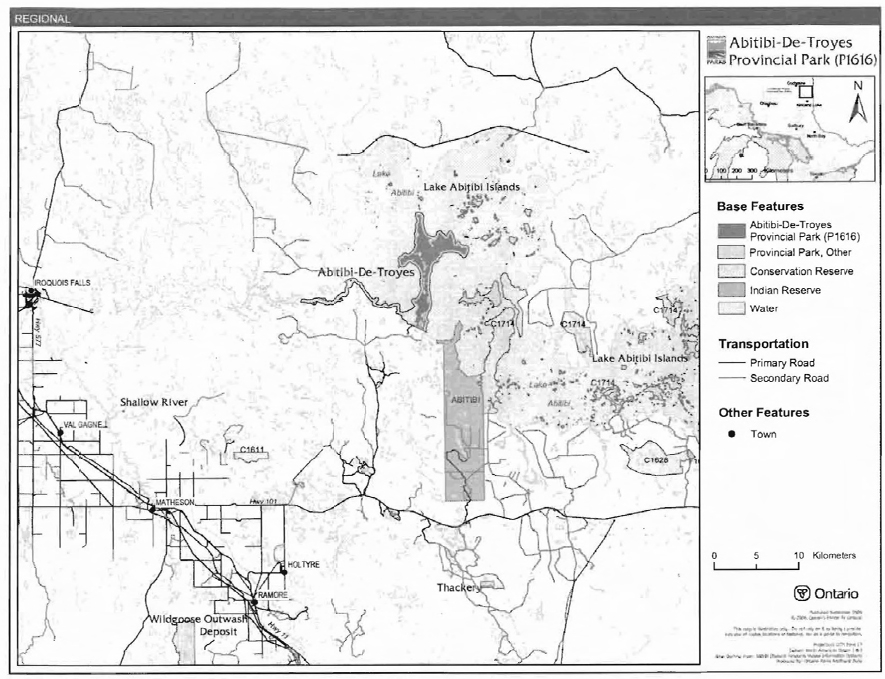
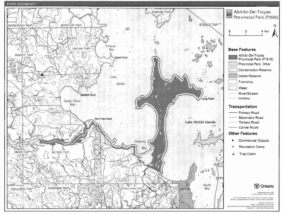
Abitibi-De-Troyes Provincial Park has been reconfigured and reclassified as of April 2005 (O. Reg. 180/05). This park is located in the geographic township of Kerrs and an unsurveyed portion of land north of the geographic township of Milligan. The park encompasses approximately 4,292 hectares of Crown land, primarily in the Ministry of Natural Resources (MNR) Cochrane District, with a small portion in the Kirkland Lake District (Figure 1).The park is positioned along the lower portion of the Abitibi River, from Couchching Fails to Lake Abitibi, and the southern shore of the lake to the Long Point peninsula (Figure 2). Long Point is entirely within the park, with Low Creek acting as a portion of the boundary for the park at the base of the point.
The intent of the Abitibi-De-Troyes Reconfiguration and Reclassification was described in Ontario’s Living Legacy Land Use Strategy (OMNR 1999) and resulted in a reduction of the pre existing park which had been a waterway class to make it an historical class park. The majority of the river portion of the park was deregulated because the substantial amount of private land within the area that made the management of the waterway class provincial park difficult.
1.1 Objectives
Abitibi-De-Troyes Provincial Park will be managed consistent with the four objectives for provincial parks:
Protection: To protect provincially significant elements of the natural and cultural landscapes of Ontario.
Recreation: To provide provincial park outdoor recreation opportunities ranging from highintensity day-use to low-intensity wilderness experiences.
Heritage Appreciation: To provide opportunities for exploration and appreciation of the outdoor natural and cultural heritage of Ontario.
Tourism: To provide Ontario’s residents and out-of-province visitors with opportunities to discover and experience the distinctive regions of the Province.
2.0 Management Context
The purpose of this Interim Management Statement (IMS) is to provide direction to ensure the custodial management of park resources. Future park planning may be undertaken as required to provide direction on significant decisions regarding resource stewardship, development, operations and permitted uses.
Park management will follow direction from:
- Provincial Parks Act (1990) and regulations
- Ontario Provincial Parks Planning and Management Policies (OMNR 1992)
- Ontario’s Living Legacy Land Use Strategy, policy clarifications (OMNR 2000), amendments, and related direction
- Crown Land Use Policy Atlas (OMNR 2004a).
In addressing custodial management obligations to protect park values and ensure public health and safety, Ontario Parks will ensure that policy and Environmental Assessment Act (1990) requirements are implemented.
Figure 1: Regional Context

Enlarge Figure 1: Regional Context
Figure 2: Park Boundary
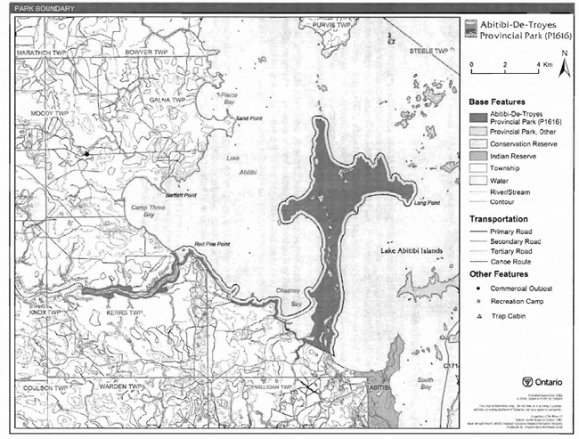
Enlarge Figure 2: Park Boundary
2.1 Environmental Assessment
As a part of the MNR. Ontario Parks is a public sector agency which is subject to the Environmental Assessment Act. Park management will be carried out in accordance with legislation, policies, and guidelines that are required under A Class Environmental Assessment for Provincial Parks and Conservation Reserves (OMNR 2005).
3.0 Park Features and Values
Abitibi-De-Troyes Provincial Park is 4,292 hectares in size. The park encompasses a section of the Abitibi River, and the southern shore of Lake Abitibi to Long Point, and all of Long Point.
This historical class park contains many archaeological sites on Long Point and at the mouth of the Abitibi River on Lake Abitibi. The park is named for Chevalier de Troyes who is believed to have portaged across Long Point in the late 171 century on an expedition to attack the Hudson’s Bay Company posts on James Bay.
3.1 Geological Features
The bedrock of Abitibi-De-Troyes Provincial Park is within the Abitibi greenstone belt, in the central part of the Abitibi Subprovince, in the Superior Province of the Precambrian shield. Within the Ontario Provincial Park system, the bedrock geology of Abitibi-De-Troyes Provincial Park is considered to be locally significant for its representation of components of the Abitibi greenstone belt. The surficial geology is considered to be locally significant for its deposits and landforms. The park itself is considered to be regionally significant for its geomorphic representation of Lake Abitibi, which is the largest remnant in Ontario of glacial Lake Ojibway (Frey and Ouba 2002).
The surficial deposits are Late Wisconsinan in age, except for the organic deposits, which were accumulated from Late Wisconsinan to Recent time periods. Glacial striae record the southeast direction of the latest ice advance over the park. Till deposited in the area was removed by postglacial flooding. The till record may be preserved beneath the glaciolacustrine deposits of the park (Frey and Duba 2002).
Outwash sands and gravels were channelled into an esker on Long Point. Segments of the esker remain, but they have been modified into subdued relief by glacial lake action. The trace of the esker segments is visible by elevated relief and several kettle lakes (Frey and Ouba 2002).
Following the Late Wisconsinan glacial recession about 9,000 years ago, the area was flooded for approximately 1,000 years by glacial Lake Ojibway. Abitibi-De-Troyes Provincial Park is covered almost entirely by the glaciolacustrine clay and silt from glacial Lake Ojibway. As the glacial lake drained, organic deposits accumulated at lowland drainages into the present Lake Abitibi (Frey and Ouba 2002).
3.2 Biological Features
The park is dominated by intolerant hardwoods and mixedwoods, as well as lowland conifers. trembling aspen and birch-dominated mixedwoods flank the Abitibi River, the south shore of Lake Abitibi, and the central axis of the Long Point peninsula. In particular, intolerant hardwood stands and occasional pine stands dominate the driest sites, including the crests of esker fragments, old beach ridges, and scattered high bluffs. Red pine, Jack pine, and, very rarely, white pine, occur in small, isolated stands on the driest of these sites. They also occur on former beach ridges on the west side of the Long Point peninsula, which is most likely composed of reworked material from the glaciofluvial ice-contact landform (Morris 2004).
On mesic sites, typically found on the finer glaciolacustrine deposits, intolerant hardwoods are less prominent than coniferous species.Balsam fir, white spruce, white cedar, and occasionally black spruce are found on mesic sites. Wet, forested sites occur on poorly-drained areas of glaciolacustrine plain and peatland deposits. They are typically dominated by black spruce and white cedar, which are sometimes mixed with upland species such as white birch, white spruce, and balsam fir. Black ash and balsam poplar are common subordinate species; yet these species only occasionally reach local prominence (Morris 2004).
3.3 Cultural Setting
The specific cultural values for the reconfigured Abitibi-De-Troyes Provincial Park have not been investigated; however, there has been an extensive investigation into the cultural heritage of the Abitibi River area. The Lake Abitibi Background Study provides a comprehensive chronology of the investigations into the cultural aspects of this area (Sadler 1980).
Within Abitibi-De-Troyes Provincial Park, there are approximately 14 documented archaeological sites located along the shoreline of the Abitibi River and on Long Point. The Long Point area contains two sites of historic value. One site, called "The Lonely Tombstone," is where a voyageur shot himself while taking his gun out of the canoe in 1865. The other site is the portage trail believed to be used by Aboriginal people and early fur traders, including the de Troyes expedition to James Bay in 1686 (Sadler 1980).
Future planning will use a provincial framework, The Topical Organization of Ontario History (OMNR 1974), and updates and discussions with other agencies, Aboriginal communities, and other interests to identify cultural heritage values and features and their significance within Abitibi De-Troyes Provincial Park. This information may be used to develop management guidelines to conserve and protect representative archaeological and historical values and features, as well as provide direction for further research.
3.4 Recreation
Recreational activities in Abitibi-De-Troyes Provincial Park include boating, waterfowl hunting, canoeing, camping, and nature viewing. Due to the hazardous conditions of the open water of Lake Abitibi, sport fishing usually occurs around the mouth of Abitibi River, and usually during the spring spawning season. This area is known to have a canoe route (Abitibi River Canoe Route) associated with it; however access, hazardous conditions, and the availability of more desirable locations have reduced the popularity of this area for canoeing (Harper 2003).
4.0 Aboriginal Uses
Abitibi-De-Troyes Provincial Park lies within the 1905 Treaty 9 boundary. The nearest First Nation is Wahgoshig First Nation, located just west of the park.
First Nations have expressed interest in and have shared knowleqge of the park and surrounding area. Aboriginal communities have used the area for hunting, trapping, fishing, gathering and travel. These uses may continue, subject to public safety, conservation and other considerations.
Any communications and cooperation between Aboriginal communities and the MNR for planning and operations purposes will be done without prejudice to any future discussions or negotiations between the government of Ontario and Aboriginal communities.
5.0 Stewardship Policies
The removal, damage or defacing of Crown properties, natural objects, relics, and artefacts is not permitted in provincial parks (Provincial Parks Act).
Non-native species will not be deliberately introduced into the park. Where non-native species are already established and threaten park values (i.e., has become invasive), a strategy to control the species may be developed (OMNR 1992).
5.1 Terrestrial Ecosystems
5.1.1 Harvesting
Commercial forest operations are not permitted within the park. The harvest of non-timber forest products such as club moss, Canada yew, etc., will not be permitted (OMNR 1992).
Existing authorized wild rice harvesting may continue. New operations will not be permitted.
There are no fuelwood cutting permits currently issued for the park. New permits will not be issued (OMNR 2000).
5.1.2 Insects and Disease
Insects and diseases may be managed where the aesthetic, cultural, or natural values of the park are threatened. Control measures will follow guidelines established by the Ontario Ministry of the Environment (MOE) and MNR. Whenever possible, biological control measures will be given preference over the use of chemicals (OMNR 1992).
5.1.3 Fire
Abitibi-De-Troyes Provincial Park is located within the Boreal Fire Management Zone. In accordance with existing provincial park policy and the Forest Fire Management Strategy for Ontario, forest fire protection will be carried out in the park as on surrounding lands (OMNR 2004b). Whenever feasible, MNR's Forest Fire Management program will use techniques that minimize damage to the landscape, such as limiting the use of heavy equipment or limiting the number of trees felled during response efforts (OMNR 2004b).
5.1.4 Wildlife Management
Abitibi-De-Troyes Provincial Park is located within Wildlife Management Units 27 and 28. The removal or harassment of non-game animals is not permitted (Provincial Parks Act).
Hunting
Sport hunting is permitted to continue. Considerations for public safety and resource conservation with respect to hunting may be made through future planning, which would include public and Aboriginal consultation (OMNR 2000).
The Fish and Wildlife Conservation Act (1997) and the Migratory Birds Convention Act (1994) govern hunting within the park. The Ontario Hunting Regulations Summary contains regulations specific to this area. The harvest of bullfrogs or snapping turtles is illegal in provincial parks.
Bear Management Areas
There are no Bear Management Areas (BMAs) within Abitibi-De-Troyes Provincial Park. New BMAs will not be permitted.
Trapping
Abitibi-De-Troyes Provincial Park includes portions of three trapline areas: CC31, CC49 and CC59 (Figure 3).
Figure 3: Trapline Areas
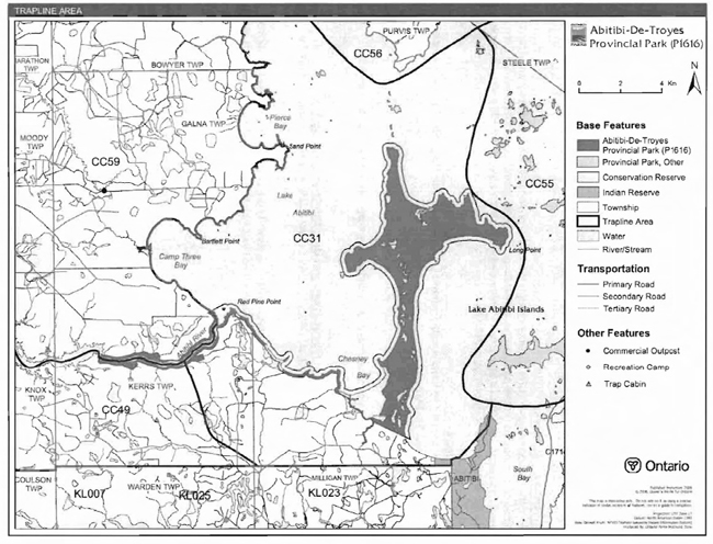
Enlarge Figure 3: Trapline Areas
Existing commercial fur harvesting operations may continue where the activity has been licensed or permitted since January 1, 1992. New operations, including trap cabins and trails, will not be permitted (OMNR 2000; 2003). Transfers of active trap line licenses are permitted, subject to a review of potential impacts and the normal transfer or renewal conditions that apply.1
5.1.5 Adjacent Land
Forestry
The land adjacent to the park is within the Iroquois Falls Forest Management Unit (MU) #012. This MU is currently managed by Abitibi Consolidated Inc. The current forest management plan is in effect until 2026 and will be reviewed in 2011 (OMNR 2006).
Provincial Parks
Three provincial parks are located near Abitibi-De-Troyes Provincial Park: Lake Abitibi Islands, Thackeray, and Wildgoose Outwash Deposit provincial parks.
Conservation Reserves
The conservation reserve (CR) network complements the provincial park system by protecting representative natural areas and special landscapes. Three CRs are located near Abitibi-DeTroyes Provincial Park: McDougal Point Peninsula CR, Trollope Lake Burnt Hill Poplar Spruce CR and Shallow River Poplar Outwash CR.
General Use Areas
Two general use areas, the Lake Abitibi General Use Area and the Southern Resource General Use Area, surround the park.
5.1.6 Land Disposition
New land disposition for the private use of individuals or corporations will not be permitted (OMNR 1992; 2000).
Land Use Permits, Licenses of Occupation, and Unauthorized Occupations
There are no land use permits (LUP) within the park. New LUPs for personal use will not be established in the park.
There are no known licensed occupations within the park. There are unauthorized occupations (UOs) within the park.Unauthorized occupations will be dealt with, on a case by case basis, after more information has been gathered.
Patent Land
There are no parcels of patent land within Abitibi-De-Troyes Provincial Park.
Boat Caches
There are no authorized boat caches located within the boundary of Abitibi-De-Troyes Provincial Park. Boats are not permitted to be left unattended in the park without written permission from the superintendent under the authority of the Provincial Parks Act.
5.1.7 Access and Crossings
Access
Abitibi-De-Troyes Provincial Park is accessible by water and air.
Lake Abitibi is accessed on its north side at an access point on Northeast Bay near Eades, on the abandoned Canadian National Railway (CNR) line. This access point is accessible via a forest access road. A second access point is located on the southern shore of Lake Abitibi in Ghost River Bay, at the mouth of the Ghost River. This access point is accessible by a secondary road branching off of Highway 101 (Harper 2003). Abitibi-De-Troyes Provincial Park is also accessed from the Abitibi River. Twin Falls Marina and the Abitibi River Access Point are located near Iroquois Falls, which is approximately 30 kilometres from the park via the Abitibi River.
Float plane access to the park via Lake Abitibi is not advisable as the lack of clarity of the water makes it impossible to view shallowly-submerged rocks and shoals.
Roads
There are no existing highways, highway corridors, primary, or secondary roads within the boundary or in close proximity to Abitibi-De-Troyes Provincial Park.
There is a network of tertiary roads south of the site, e.g., two tertiary roads abutting and enter the site in the Chesney Bay area. These are believed to be very rough trails and these are difficult to access. The Chesney Bay area and Red Pine Point are accessible using the above mentioned tertiary roads. The use of these roads will be determined through future planning.
Recreational Trails
Canoe Routes: Lake Abitibi and the Abitibi River were part of a traditional canoe route for Aboriginal people and fur traders. Difficult access and hazardous conditions have reduced the popularity of Lake Abitibi as a canoeing destination.
All-Terrain Vehicle Trails: There are no authorized ATV trails within the park boundary; however, there may be some existing unauthorized ATV use on forest and tertiary access trails within the park. Unauthorized ATV trails found in the park will be closed. Off-trail ATV use is not permitted (OMNR 2000).
Other Trails: There are currently no other authorized recreational trails within the park. New trails (e.g., hiking) may be developed if the need arises. Any proposed development within the park is subject to Environmental Assessment Act requirements.
5.2 Aquatic Ecosystems
Sustaining the quality of water resources is integral to the protection of park and adjacent land values. The MOE enforces applicable legislation and regulations for water quality.
5.2.1 Water Management
The Twin Falls Dam on the Abitibi River is outside of the park, but it influences water levels on Abitibi River and Lake Abitibi. The dam is owned and operated by Abitibi Consolidated Inc.
New commercial hydroelectric development will not be permitted in the park (OMNR 2000).
Fisheries Management
Abitibi-De-Troyes Provincial Park primarily supports fishing for Northern Pike and Walleye. Yellow Perch, Lake Whitefish, Round Whitefish, Longnose Sucker, White Sucker, and Freshwater Drum are also present in the lake. Fisheries management will complement the maintenance and enhancement of native, self-sustaining fish populations (OMNR 1992).
Sport Fishing
Sport fishing is permitted within the park. This activity is governed by legislation and regulations in the Fish and Wildlife Conservation Act and the Fisheries Act (1985). The Recreational Fishing Regulations Summary contains details on the applicable regulations for this area.
Commercial Baitfish Harvesting
A portion of one baitfish harvesting area (BHA) is within Abitibi-De-Troyes Provincial Park (Figure 4). The BHA is in the Kirkland Lake MNR District and is allocated for Kerrs Township.
Existing commercial baitfish harvesting may continue where the activity has been licensed or permitted since January 1, 1992. This activity may be subject to conditions identified through future park planning or fisheries management plans. New baitfish licenses will not be permitted (OMNR 2000; 2003).
Fish Stocking
The stocking of native fish species may be considered through park management planning, with full public and Aboriginal consultation. Non-native fish species will not be deliberately introduced into park waters (OMNR 1992).
6.0 Operations Policies
6.1 Recreation Management
Future planning, with full public and Aboriginal consultation, will review direction on motorized and non-motorized recreation uses.
6.1.1 Motorized Recreation
Motorboats
The use of motorboats is permitted to continue, unless park values are being threatened (OMNR 2004a).
Aircraft
Aircraft landings are permitted within Abitibi-De-Troyes Provincial Park (OMNR 2004a). All aircraft landings are subject to regulation and valid aircraft landing permits issued by the park superintendent under the authority of the Provincial Parks Act.
Snowmobiles
Snowmobile use on established routes for recreational ice fishing may be occurring. This use will need to be monitored and may only continue if park values are not threatened. Off-trail snowmobile use is not permitted within the park.
All-Terrain Vehicles
There are no authorized ATV trails within the park. Off-road use of all terrain vehicles will not be permitted within the park.
6.1.2 Non-Motorized Recreation
Camping
There are no managed campsites in Abitibi-De-Troyes Provincial Park; however, there are a number of existing locations where recreational users have traditionally camped. In order to protect the natural and cultural heritage values within the park, it may be necessary to close some areas to camping under the Provincial Parks Act. Infrastructure will be permitted in order to protect park features and values in response to use, environmental deterioration and environmental protection requirements. Any proposed development in the park must fulfill the requirements of the Environmental Assessment Act.
Figure 4: Baitfish Harvesting Areas

Enlarge Figure 4: Baitfish Harvesting Areas
Hiking
There are no authorized hiking trails within the boundaries of this park. If there is an identified need, the development of new hiking trails may be considered. Trail infrastructure to protect park values and features will be permitted. Any proposed development within the park is subject to Environmental Assessment Act requirements.
Canoeing/Kayaking
The canoe route and portages within Abitibi-De-Troyes Provincial Park are currently unmanaged. Existing uses may continue, unless park values are threatened (OMNR 2004a). Infrastructure to protect park features and values may be permitted and developed in response to use, environmental deterioration and environmental protection requirements.
6.1.3 Emerging Recreational Uses
There are emerging recreational uses for which there is limited or no policy to deal with their management (e.g., adventure racing and geocaching). The park superintendent will use legislation, policy, and guidelines which are in place to manage emerging uses in the interim.
6.2 Development
There is no existing park infrastructure located within the park. Infrastructure to protect park features and values may be permitted and developed in response to use, environmental deterioration, and environmental protection requirements. Any proposed development within the park is subject to the Environmental Assessment Act.
6.3 Commercial Tourism
New commercial tourism facilities may be considered where they would be consistent with park policy (OMNR 2004a). Any development must meet the requirements of the Environmental Assessment Act.
7.0 Cultural Resources
An assessment of the cultural resources specific to the park has not yet been completed. The management of any cultural values within this park will be directed toward protection and heritage appreciation (OMNR 1992).
8.0 Heritage Education
Literature and other supporting information may be developed to describe the park in the context of Ontario’s provincial park system. Boundary limits, significant heritage features and permitted uses of the may be included in park literature.
Prospective park visitors may be informed about the sensitivity and significance of park values through park literature.
9.0 Research
Scientific research by qualified individuals which contributes to the knowledge of natural or cultural history, or to environmental or recreational management, may be encouraged in the park. Ontario Parks will encourage institutions, such as universities, to undertake research projects.
All research programs will require the approval of Ontario Parks and are subject to park policy and other applicable legislation. Any materials removed from the park will remain the property of Ontario Parks.
Approved research activities and facilities will be compatible with the park’s protection objective. Any site which is affected by research will be rehabilitated as closely as possible to its original state. Environmental Assessment Act requirements will apply.
10.0 References
Canadian Environmental Protection Act, 1999.
Environmental Assessment Act, 1990.
Fish and Wildlife Conservation Act, 1997.
Fisheries Act, 1985.
Frey, E., and D. Duba, 2001. P1616 Abitibi-de Troyes Provincial Park Earth Science Checksheet. Ontario Ministry of Natural Resources (OMNR).
Harper, T., 2003. Abitibi de Troyes Provincial Park P1616 Recreation Inventory Report- Version 1.1. (OMNR).
Morris, E.R., 2004. Abitibi de Troyes Provincial Park Life Science Checksheet. Ontario Ministry of Natural Resources, Ontario Parks, Northeast Zone.
Ontario Ministry of Natural Resources, 1974. A Topical Organization of Ontario History. Historic Sites Branch Division of Parks.
Ontario Ministry of Natural Resources, 1992. Ontario Provincial Parks Planning and Management Policies. 1992 Update.
Ontario Ministry of Natural Resources, 1999. Ontario’s Living Legacy Land Use Strategy. July 1999. Queen’s Printer for Ontario.
Ontario Ministry of Natural Resources, 2000. Ontario’s Living Legacy Land Use Strategy (Policy Clarification).
Ontario Ministry of Natural Resources (OMNR), 2003. Directions for Commercial Resource Use Activities in Provincial Parks and Conservation Reserves. 5 pp.
Ontario Ministry of Natural Resources, 2004a. Crown Land Use Policy Atlas.
Ontario Ministry of Natural Resources (OMNR), 2004b. Forest Fire Management Strategy for Ontario.
Ontario Ministry of Natural Resources (OMNR), 2005. A Class Environmental Assessment for Provincial Parks and Conservation Reserves.
Ontario Ministry of Natural Resources, 2006. List of Forest Management Units (MU) in Ontario (2006-2007). Online. Accessed January 25, 2007. http://ontariosforests.mnr.gov.on.ca/ (link no longer active)
Pesticides Act, 1990.
Provincial Parks Act, 1990.
Sadler, S.E. 1980. Lake Abitibi Background Study Northern Frontier Assessment Unit. (OMNR).
Taylor, K.C., R.W. Arnup, B.G. Merchant, W.J. Parton, and J. Nieppola, 2000. A Field Guide to Forest Ecosystems of Northeastern Ontario (2nd ed.). Queen’s Printer for Ontario.
11.0 Appendix A: Background Information
| Name | Abitibi-de Troyes Provincial Park (P1616) |
|---|---|
| Classification | Historical |
| Ecoregion/Ecodistrict | 3E I 3E-6 |
| OMNR Administrative Region/District | Northeast Region - Cochrane and Kirkland Lake Districts |
| Total Area (ha) | 4,292 |
| Regulation Date and Number | April 2005 (O. Reg. 180/05). |
Representation
Earth Science:
Abitibi-De-Troyes Provincial Park is within the Abitibi greenstone belt in the central part of the Abitibi Subprovince. in the Superior Province of the Precambrian shield.The Abitibi Subprovince is one of many elongated orogenic terranes (subprovinces) of distinctive structure and volcanic, sedimentary and plutonic rock assemblages that accreted southward in the early Precambrian. The Abitibigreenstone belt is the largest metavolcanic-metasedimentary complex of the Abitibi Subprovince.
These geological environments are part of the modern organization of the complex products of late Archean orogenic events in the Superior Province. As such,their representation in Abitibi-DeTroyes Provincial Park contributes to the conservation of the "Early Archean Basement" and "Late Archean Volcanic Islands and Sedimentary Basins" Precambrian environment themes (Frey and Duba 2001).
Exposed bedrock in the vicinity of Abitibi-De-Troyes Provincial Park is limited to a small area at and adjacent to its western extremity. The rocks are late Archean massive and pillowed metabasalts of the 2.75 to 2.70 billion years old (Ga) Abitibi greenstone belt, intruded by Archean feldspar porphyry and diabase dikes. One very small outcrop of a Paleoproterozoic diabase dike of the 2.15 Ga Preissac dike swarm has been mapped in the park, near the inlet of the Abitibi River (Frey and Duba 2001).
Following Late Wisconsinan glacial recession, approximately 9,000 years ago, the area was flooded for approximately 1,000 years by glacial Lake Ojibway.Abitibi-De-Troyes Provincial Park is covered almost entirely by glaciolacustrine clay and silt of glacial Lake Ojibway. Small esker segments on Long Point have been subdued by glacial lake action. Organic deposits are accumulating at lowland drainages into Lake Abitibi. These features correspond to components of the Quaternary Algonquin stadiail-Timiscaming interstadial-Driftwood stadial environmental themes (Frey and Duba 2001).
Within the Ontario Provincial Park system, the bedrock geology of Abitibi-De-Troyes Provincial Park is locally significant in it representation of components of the Abitibi greenstone belt. Surficial geology is locally significant in its deposits and landforms.The park is regionally significant in its geomorphic representation of Lake Abitibi, the largest Ontario remnant of glacial Lake Ojibway.
Although resistant to most human activities, the bedrock exposures of Abitibi-De-Troyes Provincial Park are susceptible to graffiti, uncontrolled bedrock sampling and unplanned bedrock disturbances. However the main outcrop area at (flooded) Couchiching Falls been disturbed by quarrying and log boom operations. The Long Point peninsula is particularly sensitive to foot traffic eroding glaciolacustrine sands of the esker feature. Appropriate monitoring and possibly cautionary warnings or controls should be implemented if use increases.The area is locally popular for waterfowl hunting and attracts numerous seasonal visitors.
Life Science:
Abitibi-De-Troyes Provincial Park is located around the west basin of Lake Abitibi. At present, the regulated park includes the Long Point Peninsula, a section of the shoreline between the peninsula and Abitibi River mouth, and open water sections of the Abitibi River and several of its tributaries.
The park is largely dominated by intolerant hardwoods and mixedwoods, as well as lowland conifers. Trembling aspen and birch-dominated mixedwoods flank the Abitibi River, south shore of Lake Abitibi, and central axis of the Long Point peninsula. In particular, intolerant hardwoods stands and occasionally pine stands dominate the driest sites,including the crests of esker fragments, old beach ridges, and scattered high bluffs. Red pine, Jack pine, and very rarely white pine, occur in small, isolated stands on the driest of these sites. They also occur on former beach ridges on the west side of the Long Point peninsula, which are most likely composed of reworked material from the glaciofluvial ice-contact landform.
On mesic sites, typically found on the finer glaciolacustrine deposits, intolerant hardwoods are less prominent than coniferous species (balsam fir, white spruce,white cedar, and occasionally black spruce).
Wet forested sites occur on poorly-drained areas of glaciolacustrine plain and peatland deposits. They were typically dominated by black spruce and white cedar, sometimes mixed with more upland species such as white birch, white spruce, and balsam fir. Black Ash, and balsam poplar are common subordinate species, yet these species only occasionally reached local prominence.
Shoreline bluffs on the west side of the peninsula are typically formed of gravelly sand, occasionally broken by small rock headlands, whereas bluffs on the east side are formed of varved clays. Beach ridges often front areas of wetland clay plain basins. This may be one of the best examples of thicket dominated swamps in the region for the park system. Stand descriptions from the Forest Resource Inventory indicated these thicket swamps are mixed with coniferous species.
On the Glaciofluvial Ice-contact deposits, the significant landform-vegetation units included Open Bog, Recent Cuts; Open Fen; and Treed Fen. On the Glaciolacustrine deposits, the significant landform-vegetation units included Open Bog, Dense Deciduous Forest, Recent Cuts and Treed Fen. Note that the Open Bog vegetation unit used in the coarse landform/vegetation analysis also includes Poor Fen representations. There are no true bogs of a mappable size in Abitibi-DeTroyes Provincial Park.
Modern anthropogenic disturbances to the site are very limited. However, Lake Abitibi is managed as a reservoir for hydroelectric power generation. Parts of the site have been permanently flooded, while others continue to be affected by wave action.
The manual landform/vegetation analysis of the reconfigured Abitibi-De-Troyes Provincial Park yielded 30 landform/vegetation combinations.This site should be considered highly diverse, as indicated by this large number of landform/vegetation units.Relatively high physical diversity, often associated with biological diversity or biodiversity, is known to occur in landscapes containing glaciofluvial ice-contact and glaciolacustrine beach ridge and swale landforms.
Abitibi-De-Troyes Provincial Park probably does not provide a significant headwater function to the much larger Lake Abitibi or the Abitibi River system. Although Abitibi-De-Troyes Provincial Park is part of a substantial complex of protected areas in the Lake Abitibi area,none of these protected areas are connected through terrestrial linkages. Forested areas surrounding Abitibi De-Troyes-Lake Abitibi area have been recently and extensively cut-over. As such, Lake Abitibi’s protected areas, including Abitibi-De-Troyes, are presently of high local importance as they provide a significant portion of the mature and occasionally old-growth forest habitat in the area. The configuration of the site is such that it does not contain substantial amounts of interior forest habitat, as adjacent cut-overs have created edge-habitat along the Lake Abitibi shore and Abitibi River shore, and the numerous ponds and sparsely-treed depressions in the Long Point peninsula also create natural edge habitats.
Forests in the Lake Abitibi area, including those of Abitibi-De-Troyes Provincial Park, have experienced a variety of natural disturbance events. In 1921, a large fire burned an area between Couchiching Falls and the south shore of Lake Abitibi near the Abitibi River mouth. Since then, only two small fires are known to have occurred. In 1976, a small fire was reported on the small, west-projecting peninsula off of the Long Point peninsula, and in 1987 a small fire was reported near the Abitibi River, about two kilometres upstream of Couchiching Falls. Other fires may have occurred in the site, but these were not reported or recorded by MNR.
Several significant wildlife areas or features occur in or near Abitibi-De-Troyes Provincial Park. They include a very small portion of a Moose Early Wintering area near Couchiching Falls. The large wetland complexes in the Chesney Bay are Waterfowl Staging Areas. A Lake Whitefish spawning site occurs off the eastern tip of the Long Point Peninsula. A Northern Pike spawning site occurs at Low Creek, at the base of the Long Point peninsula. An Osprey nest was reported north of the Abitibi River. The nest could not be confirmed in a recent aerial reconnaissance flight (June 2003).The bluffs on the east side of the Long Point peninsula are potential habitat for cavity nesting birds (e.g., Bank Swallows; Kingfisher).
Abitibi-De-Troyes contains approximately 370 hectares of forests which meet old-growth definitions. The majority of the old growth representations include balsam fir-dominated mixedwoods, which reaches old growth conditions relatively early (70 years). Other old growth representations include Undifferentiated Mixedwoods, Cedar-Lowland Conifer Forests, and Black Spruce Lowland forests.
The site contains at least eight landform/vegetation representations which are not represented elsewhere in Ecodistrict 3E-6. As such, Abitibi-De-Troyes is considered provincially significant as it contains the best known examples of several landform/vegetation units within Ecodistrict 3E-6.
Erosion of natural features, particularly shoreline bluffs on the east side of the Long Point peninsula, should be evaluated to determine if water management in Lake Abitibi is a potential threat to long-term damage to the area and possible archaeological features.
Cultural Resources:
There are approximately 14 documented archaeological sites located along the shoreline of the Abitibi River and on Long Point, which are located within the reconfigured boundary of Abitibi-DeTroyes Provincial Park.
Recreation:
Boating is an existing use of some areas of Lake Abitibi. Twin Falls Marina offers boat tours from Twin Falls to the mouth of the Abitibi River. Also anglers use boating as the main mode of transportation during the fishing season. This use occurs at low levels. The long, shallow fetch of the lake allows large waves to build up in a short time, with little wind; this, coupled with the large number of rocky shoals dotting the lake and the excessive turbidity creates a hazard to navigation and aircraft landings.
Lake Abitibi and the Abitibi River are traditional canoe routes used by Aboriginal people and fur traders. This area is known to have a canoe route associated with it; however access, hazardous conditions, and the availability of more desirable locations have lowered the use of this area for this activity (Harper 2003).
The sport fishery on Lake Abitibi has been generally reserved for avid trophy anglers who are looking for a wilderness challenge. As stated earlier the fish species present in Lake Abitibi are yellow pickerel, northern pike, and lake whitefish. Due to the hazardous conditions of the open water of Lake Abitibi, fishing generally occurs around the mouths of major rivers, and usually during the spring spawning season.
Camping may be occurring in this area. Twin Falls Marina advertises drop off and pick up services to campers in the Lake Abitibi area. However, there are no documented campsites, and this activity is likely occurring at low levels.
While not confirmed, it is suspected that some level of snowmobile use associated with recreational ice fishing may be occurring in or around this park.
Inventories
| Survey Level | Earth Science | Life Science | Cultural | Recreational |
|---|---|---|---|---|
| Reconnaissance | Frey and Duba 2001 | Morris 2004 | Harper 2003 |
1Transfers include situations where a license is surrendered with a request that it be immediately reissued to another individual or organization that is assuming an existing operation. Trap cabins are considered part of a trapline and would be transferred with the trapline for the purposes of trapping. If a trapline license is revoked or surrendered, all portions of the registered line within the park will be rescinded from the legal description of the trap line (OMNR 2003).