Agassiz Peatlands Provincial Park Management Statement
This document provides direction on the management of Agassiz Peatlands Provincial Park.
2003, Queen’s Printer for Ontario
Additional copies of this publication can be obtained from:
Ministry of Natural Resources
Fort Frances District Ontario Parks
922 Scott St.
Fort Frances, ON
P9A 1J4
Telephone: (807) 274-5337
And:
Ontario Parks Northwest Zone
Suite 221D
435 James Street South
Thunder Bay, ON
P7E 6S8
Telephone: (807) 475-1321
Approval statement
This Interim Management Statement will provide interim direction for the management of Agassiz Peatlands Provincial Nature Reserve until a comprehensive Park Management Plan is prepared.
This statement will provide the basis for the subsequent preparation of the Park Management Plan.
I am pleased to approve this Interim Management Statement for Agassiz Peatlands Provincial Nature Reserve.
Tim P. Sullivan
Zone Manager, Ontario Parks
North West Zone
Prelude
The purpose of this Interim Management Statement is to identify:
- park values, which are to be protected;
- resource management prescriptions necessary to protect these values in their current state; and
- restrictions, according to existing park policy, on use of natural resources within the park.
This Interim Management Statement is not intended to replace a Park Management Plan. Rather it is intended to guide the use of natural resources and related activities within the park until such a time as a Park Management Plan is prepared.
The guidelines that have been developed are based upon information contained in the Ontario Provincial Parks Planning and Management Policies (1992) and Ontario’s Living Legacy Land Use Strategy (1999).
Background information
| Name: | Agassiz Peatlands |
|---|---|
| Classification: | Nature Reserve |
| MNR district: | Fort Frances |
| MNR region: | North West |
| Total area (ha): | |
| Ecoregion/district: | 5S |
| Date in regulation: | 1985 (regulation of OLL Addition pending) |
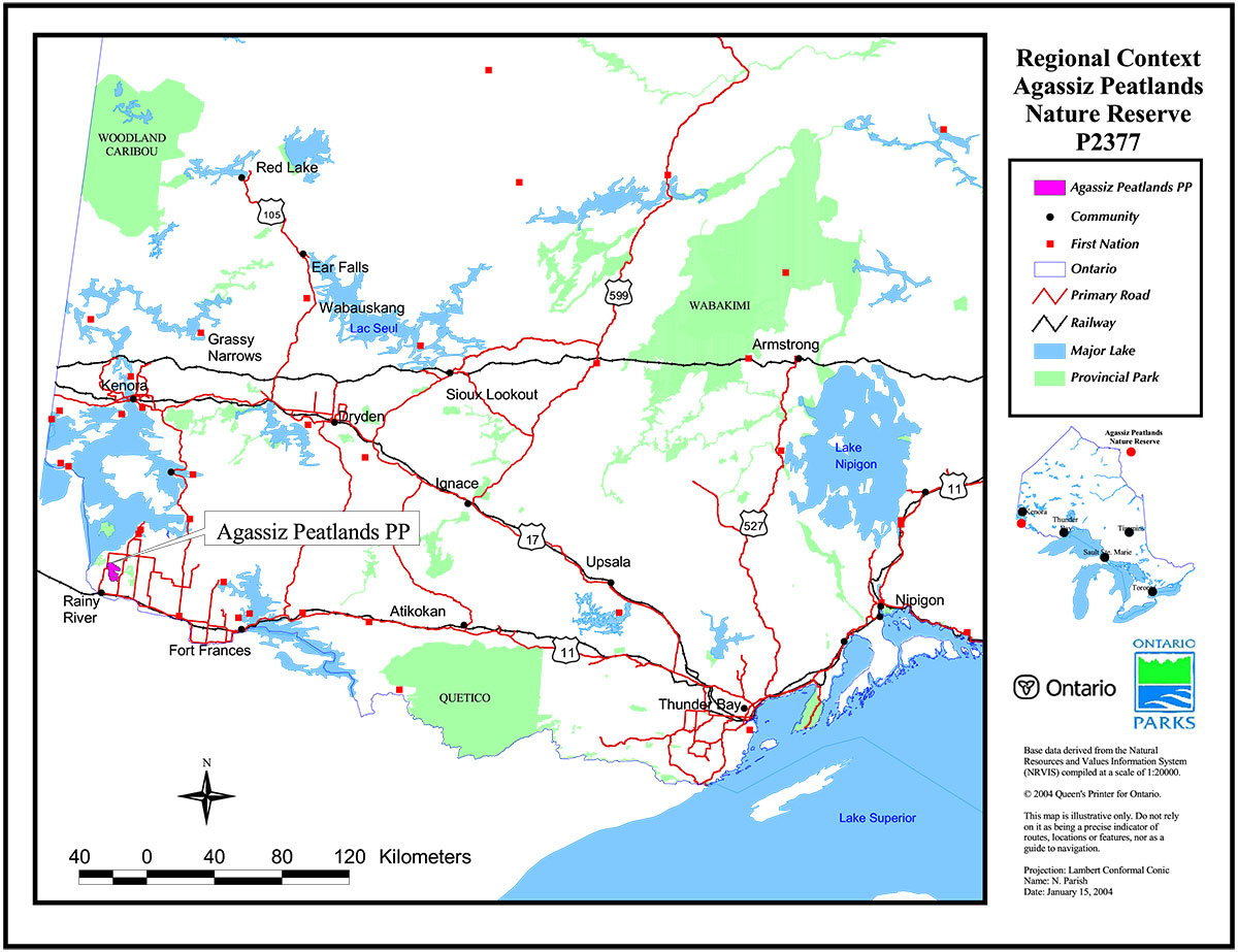
Refer to the maps at the end of the document.
Targets
Life science representation
| Site type/landscape unit | Species/communities |
|---|---|
|
|
Earth science representation
| Geological theme | Feature(s) |
|---|---|
| Unknown |
|
Cultural resource representation
| Cultural resource representation | Theme segment |
|---|---|
| Unknown | Unknown |
Recreational opportunities
| Day use | Car camping | Wilderness/backcountry |
|---|---|---|
|
N/A | N/A |
Inventories
| Level/type | Reconnaissance / completion date | Detailed/completion date | Required |
|---|---|---|---|
| Earth Science | 2002 | No | Yes- detailed |
| Life Science | 2002 | No | Yes – detailed |
| Cultural | No | No | Yes- reconnaissance |
| Recreational | No | 2002 | No |
| Other | No | No | No |
Agassiz Peatlands Provincial Nature Reserve Interim Management Statement
I. Introduction
The Agassiz Peatlands Provincial Nature Reserve was recommended as a candidate park in the Fort Frances District Land Use Guidelines (1983) and it was formally established as 'Agassiz Peatlands Provincial Nature Reserve' in 1985, under Ontario regulation 81/85. The nature reserve was later recommended for expansion as part of Ontario’s Living Legacy (OLL), a land use strategy that guides the planning and management of Crown lands in central and portions of northern Ontario. Under this initiative, released in July 1999, 378 new protected areas, including the Agassiz Peatlands Nature Reserve Addition (P2377), were identified. The formal regulation of this addition under the Provincial Parks Act is targeted for 2002 and it will be regulated under the name 'Agassiz Peatlands Provincial Park (Nature Reserve Class),' although it will continue to be referred to as a 'Provincial Nature Reserve.'
The nature reserve classification recognizes the distinctive nature habitats and landforms found in the park and it’s protection for educational purposes and as a gene pool for research to benefit present and future generations. At 5387 ha, this park includes a portion of the largest peatland complex in the southern part of Northwestern Ontario and is directly linked to the ancient lakebed of glacial Lake Agassiz. Agassiz Peatlands Provincial Park is also the most dramatic example of a northern ribbed fen in the site region and is home to many rare forms of flora and fauna, including the insectivorous linear-leaved sundew, Townsend’s jackrabbit and black terns. The park is located within the Ministry of Natural Resource’s Administrative District of Fort Frances, approximately 10 km northeast of the Town of Rainy River.
An Interim Management Statement was first completed for the Agassiz Peatlands Provincial Nature Reserve in 1986 and was then revised in 1991. This Interim Management Statement represents a synthesis of the 1991 version and new information and management directions that have arisen from Ontario’s Living Legacy and it replaces the 1991 version.
II. Land Tenure/Acquisition/Disposition
Agassiz Peatlands Provincial Nature Reserve is composed entirely of Crown Land in the Geographic Townships of Pratt and Spohn, District of Kenora. The 1985 park boundaries included Lot 10-12, Con. 3, Lots 10-12, Con. 4, and the S ½ Lot 12, Con. 5 in Pratt Township. The following lots in Spohn Townships were also included in the park’s original boundaries: No ½ of Lots 1 & 2, Con. 1, Lots 1 & 2, Con. 2, Lots 1-3, Con. 3, Lots 1-4, Con. 4 and the S ½ of Lots 1-3, Con. 5. Under Ontario’s Living Legacy (OLL), the following parcels of land in the Geographic Townships of Blue, Spohn and Pratt were recommended for addition to the existing Agassiz Peatlands Park:
Township of Blue:
- NW ¼, Section (Sec.) 27
- No ½ & SE ¼ of the SW ¼, Sec. 27
- No ½ & SW ¼, Sec. 28
- Sec. 29
- NE ¼, Sec. 30
- No ½ & SE ¼, Sec. 31
- Sec. 32
- NE ¼ & S ½, Sec. 33
- W ½, Sec. 34
Township of Spohn
- S ½ Lots 1 & 2, Con. 1
Township of Pratt:
- Lots 8-12, Con. 1
- S ½ Lot 10, Lots 11 & 12, Con. 2
- Lots 7-9, Con. 3
- S ½ Lots 8 & 9, Con. 4
The Geographic Township of Blue contains a number of unopened road allowances, four of which traverse the southern portion of the OLL Addition. Road allowances occurring along the park boundary have been excluded from the nature reserve.
There are no land use permits, leases, easements, or other forms of tenure within the park area, although one patent property occurs within recommended addition to the Agassiz Peatlands Provincial Park. The nature reserve is largely surrounded by patented property.
Guideline:
- No new sales of Crown land for the private use of individuals or corporations will be permitted in a regulated park.
- Land dispositions for private or commercial use will not be considered.
- If any portions of patent lands adjacent to or surrounded by the nature reserve become available they may be considered for addition to the park.
- According to Section 3(4) of the Provincial Parks Act, unopened road allowances that have not been closed or conveyed will become vested in the Crown on the day that the area in which the road allowance occurs is officially added to the park.
III. Aboriginal interests
Agassiz Peatlands Provincial Nature Reserve is within the Treaty 3 area, with the Rainy River Band (Wildlands Reserve 15M) being the closest First Nation. The nature reserve falls also within a larger are that is subject to on-going land claim negotiations between the Crown and local First Nations. The Native land claim by the Rainy River Band led to the exclusion of a portion of land from the 1985 park boundaries. This parcel of land is located in the northeast corner of the Wildlands Indian Reserve #15M, an area that was surrendered by the Rainy River Band in 1915.
Guideline:
- Any management guidelines will reflect the Ontario government’s approach to aboriginal rights:
- All decisions related to the identification, planning or disposition of provincial park lands, or other lands set aside to protect significant natural or cultural heritage values, will be the subject of public consultation. Aboriginal peoples who identify traditional ties to those lands will be integral to the consultation and decision making processes. In some cases there may be a need for separate consultation or negotiation processes to address Aboriginal interest in park lands. If required, some issues regarding how a park is used may also be the subjects of negotiation with Aboriginal people.
- The Government of Ontario will consider all the available options when seeking to determine the land component, if any, during negotiations involving land claim settlements with First Nations. Options for uses that involve lands not to be considered for provincial park purposes will be preferred.
- As described in the Province’s Interim Enforcement Policy (1991), aboriginal people hunting or fishing in provincial parks will be subject to all relevant treaties and However, an agreement reached between the Province and a First Nation may modify the application of those treaties and laws (Ontario Provincial Parks Planning and Management Policies, 1992).
IV. Natural Resource Stewardship
Agassiz Peatlands represents the largest, wettest, and most dramatic ribbed fen in ecoregion 5S and is directly linked to a larger peatland complex based on the lakebed of glacial Lake Agassiz. The nature reserve’s peatlands can be subdivided into two basins: a southern basin, encompassing much of the OLL Addition, which drains eastward, and a northern basin that drains northwest into the Little Grassy River System. The movement of water through the wetlands has created a complex pattern consisting of string of treed fen ridges with intervening flarks, or water tracks.
Lands and waters
Mud Lake, a small pothole lake located north of the division between the Geographic Townships of Blue and Spohn, is the only permanent waterbody within the park. This 70-hectare lake has no outlet and is fed by water draining from the surrounding peat. The west branch of the Little Grassy River, which is adjacent to the park’s northern boundary, is also fed by the Agassiz Peatlands.
The nature reserve occupies an area on the border of the felsic igneous rocks of the Sabaskong batholith to the northeast and the mafic metavolcanics of the Rainy River greenstone belt. No known rock outcrops exist within the park, and the underlying geology has been inferred from surrounding outcrops and broader-scale geological surveys. The area has been influenced by the events of the late Wisconsin period, including deposition from advances of lobes of both the Keewatin and Labradorean fronts of the Laurentide ice sheet, as well as the phases of glacial Lake Agassiz. Quaternary deposits from this time tend to be complex, reflecting the sequence of glacial events, but broadly represent examples of glaciolacustrine deposits, till and minor glaciofluvial influences. Recent deposits are the most visible features of the nature reserve, represented by the extensive area of peat deposits.
The depth of the overburden has generally hampered mineral exploration in the area. Prior mining claims did include the southern and northeast portions of the OLL Addition. Reverse circulation drilling was undertaken on these claims in 1995 to conduct geochemical sampling of till, although the result were unpromising and the claims subsequently expired. No current mining claims exist within Agassiz Peatlands Provincial Park.
Guideline:
- Commercial hydro development is not permitted.
- Peat extraction is not permitted.
- Aggregate extraction is not permitted.
- Mineral exploration and mining are not permitted within Agassiz Peatlands Provincial Nature Reserve.
Vegetation management
A total of 16 ecosite types have been identified within Agassiz Peatlands Provincial Nature reserve, the majority of which are wetland types. Forested portions of the park include small upland areas on the northwestern and northeastern margins of the wetland features. Conifer species, including tamarack and black spruce, with scattered occurrences of black ash dominate most of the park. The northwestern and northeastern portions of the park contain representation of black spruce/balsam fir/poplar mixedwoods and one small stand of eastern white cedar occurs along the eastern boundary.
Provincially rare faunal species have not been documented, although a number of species that are rare in both the ecological site region and district have been observed within the nature reserve. The OLL Addition is also the only peatland in the area to contain the insectivorous linear-leaved sundew (Drosera linearis).
Agassiz Peatlands Provincial Nature Reserve is located within the Crossroute Forest Management Unit 405, which has been issued to the Fort Frances Division of Abitibi-Consolidated Inc. This management unit is the result of the amalgamation of the former Highrock (290) and Fort Frances Flanders (827) Forests, which was scheduled to take place April 1, 2002.
Guideline:
- Commercial forest operations are not permitted.
- Fuelwood cutting is not permitted.
- Management will be directed towards on-going natural succession, unless alternative strategies are desirable.
- Non-native species will not be deliberately introduced. Where they are already established, and threaten park values, management will develop a program for their eradication.
- Insect/disease suppression of non-native infestations is permitted.
- In the absence of a fire management plan for the park, the fire management objectives for the surrounding fire zone will apply. All human-caused fires will be suppressed.
- Prescribed burning may be permitted, subject to park management planning.
- The need for a Vegetation Management Plan, which would include prescriptions for fire management, will be determined in the park management plan.
- The locations of provincially significant floral species will not be public information. Necessary measures (access/development restrictions) to protect the integrity of these populations will be implemented.
- Agricultural practices, including the manipulation of the water table, will not be permitted, except where the perpetuation of natural features and conditions is desirable.
- Ontario Parks will act as a plan advisor and reviewer during the Forest Management Planning Process, according to the Northwest Zone’s Protocol for Ontario Parks' Participation in Forest Management Planning. This process ensure that park values and park-related values are recognized and that protection and mitigation measures are worked out through the development of the forest management plan when these values are potentially effected by adjacent forestry operations.
Wildlife and fisheries management
The upland portions of the nature reserve provide habitat for many of the mammals found in the Rainy River area and may act as a refuge in a region where the surrounding area is dominated by agriculture. White-tailed deer, in particular, are frequently observed in the park. There are some signs of beaver activity in a thicket swamp in the southern portion of the nature reserve. Although the concentration of beavers is low, when compared to other areas in the MNR's Fort Frances District. Townsend’s jackrabbits are also known to occur in the area. The presence of this species is significant in that it is historically known to occur in Ontario, but its presence has not been verified recently.
The number and variety of waterfowl and upland bird species that the area supports is not well known. Given the predominance of conifer species, habitat for bird species is weighted heavily to those species favouring these forest types. Regionally unusual species, such as red-headed woodpecker, loggerhead shrike, western kingbird, black-billed magpies and sandhill cranes, may also be observed in the area, at least as occasional visitors. Habitat for the provincially vulnerable black tern (Chlidonias niger) has been noted in the area.
To date, specific surveys have not been conducted to determine the fisheries resources in Agassiz Peatlands Provincial Nature Reserve. They are most likely quite limited, as Mud Lake is the only permanent waterbody in the nature reserve.
Guideline:
- Management will be directed to the maintenance of an evolving natural succession, unless alternative strategies are desirable.
- Fish stocking of any kind is not permitted.
- Hunting, trapping and fishing by Aboriginal people exercising their Aboriginal or Treaty rights is not affected.
- Sport hunting and fishing will be addressed in Section VI – Recreation Activities
- Fur harvesting will be addressed in Section VII – Commercial Activities
V. Cultural resources
There are no known cultural resources in the Agassiz Peatlands Provincial Nature Reserve, although there is some potential for existing sites. Paleo-Indian archeological sites, associated with the shore of glacial Lake Agassiz, have been registered in the area. There are currently no registered archeological sites with Agassiz Peatlands Provincial Nature Reserve.
Guideline:
- Further inventory is required to assess the cultural resources of the park. Approved archeological fieldwork will be encouraged.
- The locations of any archeological sites will not be public information. Necessary measures (access/development restrictions) to protect the integrity of any archeological sites will be implemented.
- The need for a Cultural Resources Plan/Strategy for cultural features/sensitive areas will be determined with park management planning.
VI. Existing/proposed development
Existing development within the Agassiz Peatlands Provincial Park is minimal. Maps of the area depict a number of secondary and tertiary roads, although the many of these features are actually old survey lines and drainage ditches and all are quite over-grown. A tertiary road also exists between the old gravel pit off of Highway 600 and Mud Lake and appears to be used primarily by a local baitfish operator.
An old cut trail leads to the private property in the OLL Addition and may be used for winter access, although its does not appear to have been maintained in recent years. This same trail was used approximately six years ago for mineral exploration. Some scarring of the wetland features has occurred as a result of this operation, although it is relatively limited in extent.
There is no proposed development for Agassiz Peatlands Provincial Nature Reserve.
Guideline:
- Development of access zones will be addressed via park management planning.
- Continuing custodial management for roads contained within the park and capital development of new/additional roads will be determined through park management planning.
- Development related to agriculture is addressed in Section IV – Natural Resource Stewardship.
- Development related to snowmobile use is addressed in Section VII – Recreation Activities.
- Development related to fur harvesting is addressed in Section VIII – Commercial Activities.
- Ontario Parks' signage is permitted.
VII. Recreation activities
Recreation in Spruce Islands Provincial Nature Reserve is limited due to the lack of access (see Section IX – Access) and a low activity attraction capability. The area does have the potential to support a range of activities related to nature appreciation, such as wildlife viewing and bird watching.
Angling opportunities may exist at Mud Lake. The nature reserve is located within the Border Waters and Division 22 of the Ontario Recreational Fishing Regulations , which means that all the general and area-specific regulations, along with any of the exceptions concerning specific waterbodies, apply to Agassiz Peatlands Provincial Nature Reserve.
Guideline:
- Where compatible with park values, low-intensity day-use activities and facilities that enhance appreciation of the park will be encouraged.
- Park management planning will determine policies for recreation management.
- Sport hunting is not permitted.
- Sport fishing is permitted, subject to the relevant Ontario Fishing Regulations.
- Mechanized travel (including ATV and snowmobiles) will be restricted to access zones and will be subject to prescriptions determined through park management planning.
VIII. Commercial activities
Commercial fur harvesting is an adjacent land use to Agassiz Peatlands. A number of traplines do overlap with the nature reserve’s boundaries, but they are Resident Traplines, meaning that trapping is restricted to private land. Local First Nations may be exercising their Aboriginal and treaty rights to harvest fur within the nature reserve. No overt signs of trapping have been documented, to date.
Two Bear Management Areas (BMA) have some degree of overlap with the OLL Addition. The BMA that encompasses the portion of the OLL Addition south of the original park boundaries (FF-10-001) is currently active. The second BMA(FF-10-002), which includes the portion of the OLL Addition east of the original park boundaries, is currently inactive.
Commercial baitfish harvesting is an existing use, since baitfish block FF-31 and FF-49 overlap with the original park and the OLL Addition. Mud Lake represents the usable area to baitfish block FF-31, while there is no water within the portion of FF-49 that overlaps with the nature reserve. The blocks have been issued to two different operators, both of whom are currently active.
Guideline:
- Commercial fur harvesting is not permitted.
- Trapping by First Nations people exercising their Aboriginal or treaty rights is not effected
- Existing authorized BMA licenses will not be renewed or transferred, nor will new operations be permitted, on the portions of the BMA contained within the nature reserve. Ontario Parks will work with the MNR's Fort Frances District to formally remove the nature reserve from the relevant BMA.
- Baitfish harvesting will be phased out by December 31, 2009 on the portions of the baitfish blocks contained within the nature reserve.
IX. Access
With varying, and often significant, degrees of difficulty, access can be gained from Worthington Road #3 to the south of the park, an old trail running westward off Highway 621 south of Gameland, and Highway 600 to the west. Highway 600 is deeply ditched on both sides for drainage, as are many of the gravel roads in the area, severely limiting parking opportunities. Since the park is largely surrounded by private land, owner permission is required to use most of the access points.
Guideline:
- Access into the park via existing roads will be permitted to continue pending park management planning. Any decisions concerning the maintenance of existing roads will also be made at that time.
- Access by Aboriginal people exercising their Aboriginal or Treaty rights is not affected.
X. Client services
There are currently no client services for the Agassiz Peatlands Nature Reserve.
Guideline:
- Client services will be limited to a map/brochure until an approved park management plan is completed and all information provided will convey the message that visitors have the responsibility to protect the nature reserve. Development of a Natural Heritage Education Plan will be considered when developing the park management plan.
- Recreation programs will not be provided.
XI. Research and inventories
Reconnaissance earth and life science inventories and a recreation inventory checklist were completed for the park during summer/autumn 2001. Cultural and historical features have yet to be inventoried.
Guideline:
- Detailed earth science, life science, cultural and recreation values will be undertaken when funding permits.
- Additional research/inventories to document park values will be permitted if not in conflict with park values and consistent with the Ontario parks Research and Information Strategy.
- MNR, Ontario Parks or partnered groups and individuals may undertake research projects. The Park Superintendent/Zone Manager must approve all research applications.
XII. Marketing
Marketing of Agassiz Peatlands Nature Reserve has been limited to the acknowledgement of its role in the Ontario’s Living Legacy initiative and the protected areas system, as a whole. The Ontario Parks website also provides a brief description of the nature reserve.
Guideline:
- Any marketing of the park will focus on its status as a nature reserve and the goals and objectives of this classification.
- A park management plan may direct that a detailed Marketing Plan be developed. The scope of this plan would include provincial, national and international markets.
XIII. Sources/references
Munroe, J. 2002. Earth Science Reconnaissance Inventory Report: Agassiz Peatlands Provincial Park and Addition (P2377). Ministry of Natural Resources, Fort Frances District.
Munroe, J. 2002. Recreation Inventory Report – Agassiz Peatlands Provincial Park and Additions (P2377). Ministry of Natural Resources, Fort Frances District.
Munroe, J. 2002. Agassiz Peatlands Provincial Park and Addition (P2377): Life Science Reconnaissance Inventory Report . Ministry of Natural Resources, Fort Frances District.
Ontario Ministry of Natural Resources (OMNR). 2002. Natural Resources Values Information System (NRVIS). Fort Frances District.
OMNR. 1992 (update). Ontario Provincial Parks: Planning and Management Policies.
OMNR. 1986 (revised 1991). Agassiz Peatlands Provincial Nature Reserve Interim Management Statement.
OMNR. 1983. Fort Frances District Land Use Guidelines (DLUG).
Ross, W.A. (Regional Archeologist, Ministry of Tourism, Culture and Recreation). February 11, 2001. Personal communication.
Permitted uses tables for nature reserve class parks
Existing (Pre-OLL) nature reserves1
Commercial activities
| Activity | Permitted? | Guidelines |
|---|---|---|
| Aggregate extraction | No | |
| Bait fishing (commercial) – existing | Yes | Existing use to be phased out no later than January 1, 2010. |
| Bait fishing (commercial) – new | No | |
| Commercial fishing – existing | No | No licenses exist. |
| Commercial fishing – new | No | |
| Commercial fur harvest – existing | Yes | Existing use to be phased out no later than January 1, 2010, except for trapping by Status Indians enjoying Treaty rights. |
| Commercial fur harvest – new | No | |
| Commercial hydro development | No | New commercial development is not permitted. |
| Commercial timber harvest | No | |
| Commercial Tourism (e.g. outfitting services, outpost camps, resorts/lodges) – existing | No | No facilities/operations exist. |
| Commercial Tourism (e.g. outfitting services, outpost camps, resorts/lodges) – new | No | |
| Energy transmission & communications corridors (new) | No | These facilities should avoid park lands wherever possible. |
| Mineral exploration and development | No | |
| Wild rice harvesting - existing | Yes | Existing use to be phased out no later than January 1, 2010, except for harvesting by Status Indians enjoying Treaty rights. |
| Wild rice harvesting - new | No |
Land and resource management activities
| Activity | Permitted? | Guidelines |
|---|---|---|
| Crown land disposition – private use | No | No tenure issued by the Crown currently exists. No land disposition for the private use of individuals is permitted. |
| Crown land disposition – commercial use | No | |
| Fire suppression | Maybe | In the absence of a fire management plan for the park, the fire management objectives for the surrounding fire zone will apply. All human-caused fires will be suppressed. |
| Fish habitat management | Maybe | May be considered through planning. |
| Fish stocking – native species | No | |
| Fish stocking – non-native species | No | |
| Insect/disease suppression | Maybe | May be considered through planning. |
| Inventory/monitoring | Yes | |
| Prescribed burning | Maybe | May be considered through planning. |
| Roads (non-park use) – existing | Maybe | The use of existing roads (i.e., roads currently in use and not previously closed or abandoned) will be determined through planning. |
| Roads (non-park use) – new | No | |
| Vegetation management | Maybe | May be considered through planning. |
| Water control structure – existing | No | No structures exist. |
| Water control structure – new | Maybe | New structures may be considered through planning, but only where the perpetuation of natural features and conditions is a management objective. |
| Wildlife population management | Maybe | May be considered through planning. |
Science, education & heritage appreciation
| Activity | Permitted? | Guidelines |
|---|---|---|
| Demonstration areas | No | |
| Historical appreciation – self guided | Maybe | Support facilities to be identified through planning. |
| Nature appreciation – self guided | Maybe | Support facilities to be identified through planning. |
| Photography and painting | Yes | |
| Research | Yes | Subject to authorization. |
| Wildlife viewing | Maybe | Support facilities to be identified through planning. |
Recreation activities and facilities
| Activity | Permitted? | Guidelines | |
|---|---|---|---|
| Aircraft landing (water) | No | ||
| ATV use – on trails | Maybe | Long-term management direction will be determined through planning. Existing ATV use on authorized trails, as designated by the park superintendent, may continue in the interim, unless park values are threatened. | |
| ATV use – off trails | No | ||
| Camping | No | ||
| Horseback riding (trail) | No | ||
| Hunting | No | ||
| Mountain bike use | No | ||
| Motor boat use – private | No | ||
| Motor boat use – commercial | No | ||
| Non-motorized recreation travel (canoeing, kayaking, hiking, cross- country skiing, snowshoeing) | Maybe | Long-term management direction will be determined through planning. Existing uses may continue in the interim, unless park values are threatened. | |
| Private recreation camps ("hunt camps”) | No | ||
| Rock climbing | No | ||
| Sailing and sailboarding | No | ||
| Scuba and skin diving | No | There are no suitable areas. | |
| Snowmobiling – on trails | Maybe | Long-term direction to be determined through planning. Existing snowmobile use on authorized trails, as designated by the park superintendent, may continue in the interim, unless park values are threatened. | |
| Snowmobiling – off trails | No | ||
| Sport fishing | Yes | Consult the Ontario Recreational Fishing Regulations Summary for specific local details. | |
| Trail development | Maybe | Certain types of trails may be considered though planning. |
Nature reserve class OLL additionsfootnote 1
Commercial activities
| Activity | Permitted? | Guidelines |
|---|---|---|
| Aggregate extraction | No | |
| Bait fishing (commercial) – existing | Yes | Existing use to be phased out no later than January 1, 2010. |
| Bait fishing (commercial) – new | No | |
| Commercial fishing – existing | No | No licenses exist. |
| Commercial fishing – new | No | |
| Commercial fur harvest - existing | Yes | Existing use to be phased out no later than January 1, 2010, except for trapping by Status Indians enjoying Treaty rights. |
| Commercial fur harvest - new | No | |
| Commercial hydro development | No | |
| Commercial timber harvest | No | |
| Commercial Tourism (e.g. outfitting service, outpost camps, resorts/lodges) -existing | No | No facilities/operations exist. |
| Commercial Tourism (e.g. outfitting service, outpost camps, resorts/lodges) - new | No | |
| Energy transmission & communications corridors (new) | No | These facilities should avoid park lands wherever possible. |
| Mineral exploration and development | No | |
| Wild rice harvesting - existing | Yes | Existing use to be phased out no later than January 1, 2010, except for harvesting by Status Indians enjoying Treaty rights. |
| Wild rice harvesting - new | No |
Land and resource management activities
| Activity | Permitted? | Guidelines |
|---|---|---|
| Crown land disposition – private use | No | No tenure issued by the Crown exists. No new land disposition for the private use of individuals is permitted, except for minor dispositions in support of existing uses (e.g., reconstruction of a septic system). |
| Crown land disposition – commercial use | No | |
| Fire suppression | Maybe | In the absence of a fire management plan for the park, the fire management objectives for the surrounding fire zone will apply. All human-caused fires with be suppressed. |
| Fish habitat management | Maybe | May be considered through planning. |
| Fish stocking – native species | No | |
| Fish stocking – non-native species | No | |
| Insect/disease suppression | Maybe | May be considered through planning. |
| Inventory/monitoring | Yes | |
| Personal use permits for wood harvesting | Maybe | Long-term management direction will be determined through planning. Existing authorized permits may continue on an interim basis for properties that do not have road access. |
| Prescribed burning | Maybe | May be considered through planning. |
| Roads (non-park use) - exsiting | Maybe |
Where existing forest access roads are essential for continued access beyond the nature reserve for forest management or recreation purposes, and alternative road access does not exist, or road relocation is not feasible, existing roads will continue to be available for access. Continued use will include maintenance and may include upgrading. Where other existing access roads are essential for continued access to in-holdings (i.e. LUPs, patent land, etc.) within or beyond the park boundary, and alternative road access does not exist, or road relocation is not feasible, existing roads will continue to be available for access. Continued use will include maintenance. Unopened road allowances exist. According to section 3(4) of the Provincial Parks Act, unopened road allowances that have not been closed or conveyed will become vested in the Crown on the day that the area in which the road allowance occurs is officially added to the park. |
| Roads (non-park use) - new | No | |
| Vegetation management | Maybe | May be considered through planning. |
| Water control structure - existing | No | No structures exist. |
| Water control structure - new | Maybe | New structures may be considered, but only for the perpetuation of natural features and conditions, subject to a planning process. |
| Wildlife population management | Maybe | May be considered through planning. |
Science, education & heritage appreciation
| Activity | Permitted? | Guidelines |
|---|---|---|
| Demonstration areas | No | |
| Historical appreciation – self-guided | Maybe | Support facilities to be identified through planning. |
| Nature appreciation – self-guided | Maybe | Support facilities to be identified through planning. |
| Photography and painting | Yes | Support facilities to be identified through planning. |
| Research | Yes | Subject to authorization. |
| Wildlife viewing | Maybe | Support facilities to be identified through planning. |
Recreation activities and facilities
| Activity | Permitted? | Guidelines |
|---|---|---|
| Aircraft landing (water) | No | |
| ATV use – on trails | Maybe | Existing ATV use on authorized trails can continue subject to management prescriptions determined through planning. |
| ATV use – off trails | No | |
| Camping | No | |
| Horseback riding (trail) | No | |
| Hunting | No | Existing Bear Management Area licenses will not be renewed or transferred. New licenses will not be issued. |
| Mountain bike use | No | |
| Motor boat use - private | No | |
| Motor boat use - commercial | No | |
| Non-motorized recreation travel (canoeing, kayaking, hiking, cross- country skiing, snowshoeing) | Maybe | Long-term management direction will be determined through planning. Existing uses may continue in the interim, unless park values are threatened. |
| Private recreation camps ("hunt camps”) | No | |
| Rock climbing | No | |
| Sailing and sailboarding | No | |
| Scuba and skin diving | No | There are no suitable areas. |
| Snowmobiling – on trails | Maybe | Existing snowmobile use on authorized trails can continue subject to management prescriptions determined through planning. |
| Snowmobiling – off trails | No | |
| Sport fishing | Yes | Consult the Ontario Recreational Fishing Regulations Summary for specific local details. |
| Trail development | Maybe | Certain trails may be considered through planning. |
Map: Regional context Agassiz Peatlands Nature Reserve P2377
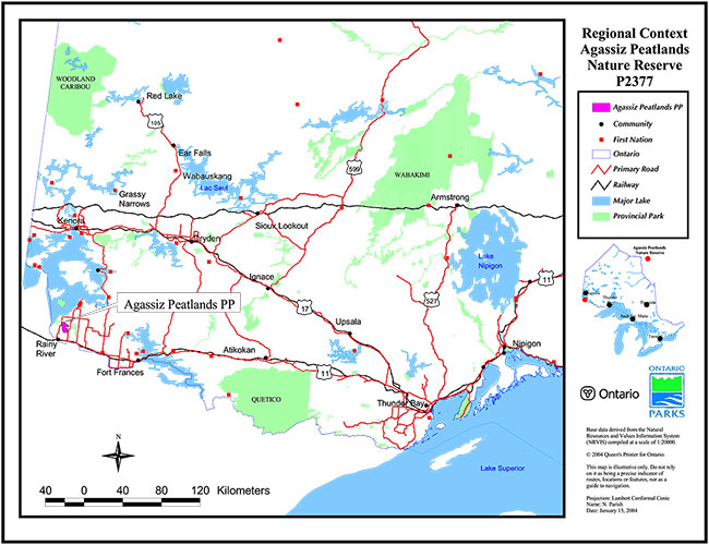
Enlarge regional context map of Agassiz Peatlands Nature Reserve P2377
Site map: Agassiz Peatlands Nature Reserve
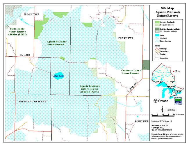
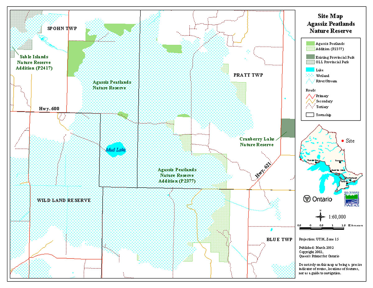
Footnotes
- footnote[1] Back to paragraph See Section II – Land Tenure/Acquisition/Disposition and the Site Map for written and visual descriptions of the park area, including the delineation between the pre-OLL portion and the OLL Addition