Amable du Fond River Provincial Park Management Statement
This document provides direction on the management of Amable du Fond River Provincial Park.
Amable du Fond River
Interim Management Statement
2006
Approval Statement
I am pleased to approve this Interim Management Statement for Amable du Fond River Provincial Park. Ontario’s Living Legacy Land Use Strategy (1999) identified this area as a waterway class provincial park. This park was regulated under the Provincial Parks Act in June of 2003 (O. Reg. 210/03).
This Interim Management Statement provides direction for the protection and management of Amable du Fond River Provincial Park.
Signed by:
Paul Bewick
Zone Manager
Northeast Zone
Ontario Parks
Signed on:
Date: November 28, 2006
1.0 Introduction
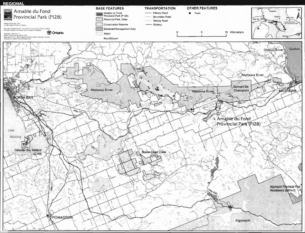
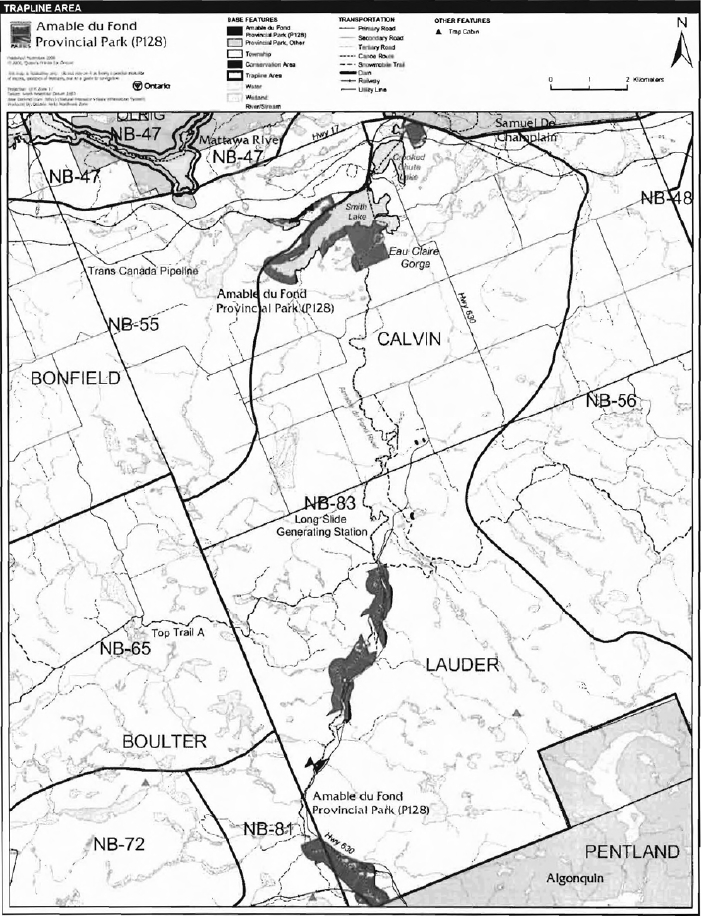
Amable du Fond River Provincial Park is located approximately 40 kilometres to the east of North Bay (Figure 1). The park covers three portions of the Amable du Fond River, between Samuel de Champlain ProvincialPark and Algonquin Provincial Park in Lauder,Boulter, and Calvin townships (Figure 2).
This 731 hectare park has been designated as a waterway class park to protect an outstanding recreational water route and to provide high quality recreational and educational opportunities.
1.1 Objectives
Amable du Fond River Provincial Park will be managed consistent with the four objectives for provincial parks:
Protection: To protect provincially significant elements of the natural and cultural landscapes of Ontario.
Recreation: To provide provincial park outdoor recreation opportunities ranging from highintensity day-use to low-intensity wilderness experiences.
Heritage Appreciation: To provide opportunities for exploration and appreciation of the outdoor natural and cultural heritage of Ontario.
Tourism: To provide Ontario’s residents and out-of-province visitors with opportunities to discover and experience the distinctive regions of the Province.
2.0 Management context
The purpose of this Interim Management Statement (IMS) is to provide direction to ensure the custodial management of park resources. Future park planning may be undertaken as required to provide direction on significant decisions regarding resource stewardship, development, operations, and permitted uses.
Park management will follow direction from:
- Provincial Parks Act (1990) and regulations
- Ontario Provincial Parks Planning and Management Policies (OMNR 1992)
- Crown Land Use Policy Atlas (OMNR 2004a)
- Ontario’s Living Legacy Land Use Strategy (OMNR 1999) and policy clarifications (OMNR 2000), amendments, and related direction.
In addressing custodial management obligations to protect park values and ensure public health and safety, Ontario Parks will ensure that policy and Environmental Assessment Act requirements are implemented.
Figure 1: Regional Setting

Enlarge Figure 1: Regional Setting map
Figure 2: Park Boundary
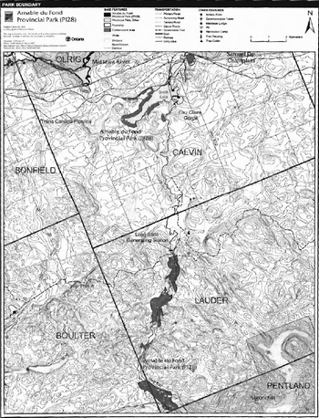
Enlarge Figure 2: Park Boundary map
2.1 Environmental assessment
As part of the Ontario Ministry of Natural Resources (MNR), Ontario Parks is a public sector agency that is subject to the Environmental Assessment Act. Park management will be carried out in accordance with legislation, policies and guidelines as required under MNR's A Class Environmental Assessment for Provincial Parks and Conservation Reserves (OMNR 2005).
3.0 Park features and values
The 84 kilometre Amable du Fond River flows north from Kioshkokwi Lake in Algonquin Provincial Park to the Mattawa River. The Amable du Fond River is the largest tributary of the Mattawa River, which merges into the Ottawa River (Harding 2002). This park, located in Ecodistricts 5E-5 and 5E-10, protects portions of the Amable du Fond waterway, from Kiosk to Samuel de Champlain Provincial Park (Morris 2002).
3.1 Geological features
The main bedrock types of Amable du Fond River Provincial Park are plutonic felsic gneisses and siliceous metasedimentary gneisses. These gneisses are of the Middle Proterozoic Powassan Domain, in the Algonquin Terrane, of the northern part of the Ontario Central Gneiss Belt of the Grenville Province (Frey and Duba 2002).
The park is covered with fine grained glaciofluvial outwash sand and alluvium. The Amable du Fond River is the remnant of a short-lived drainage of glacial Lake Algonquin into the Mattawa River valley. The geomorphic representation of this remnant of Lake Algonquin is regionally significant (Frey and Duba 2002).
3.2 Biological features
The discontinuous park includes a marsh-fen complex to the north of Smith Lake, as well as balsam fir-spruce, intolerant hardwood, and red pine-spruce scrubland communities on the shores of Smith Lake and near Crooked Chute Lake. The park contains a large black sprucewhite cedar-tamarack bottomland between Highway 630 and the Amable du Fond River. The southern parcels of the park include intolerant hardwoods,mixed conifer associations, cedaralder communities, and a riverine wetland complex. Even though the park is small and has a fragmented boundary it harbours a diversity of riparian vegetation types (Morris 2002).
3.3 Cultural setting
A cultural heritage investigation of Amable du Fond River Provincial Park has not been completed.
The Amable du Fond River may have been named after an Algonquin leader from the Montaignais tribe that settled in this area around 1848. Native artefacts have been unearthed in the Crooked Chute Lake area, illustrating the importance of the area to First Nations (Harding 2002). The river also provided an important link to lumber mills in the area during the 1870s (Harding 2002).
Any future planning will be within the context of a provincial framework, A Topical Organization of Ontario History (OMNR 1974). In addition,updates and discussions with First Nations, other agencies and stakeholders may be carried out to identify cultural heritage values and features within the park and their significance. This information may be used to develop management guidelines to conserve and protect representative archaeological and historical values and features, or to provide direction for further research.
3.4 Recreation
The recreation uses of Amable du Fond River Provincial Park are largely water-based.
The river supports several game fish species and presents angling opportunities. Brook trout occur in some parts of the river, and walleye, pike, and small mouth bass are in Smith and Crooked Chute lakes.
Motorized watercrafts are present on Smith and Crooked Chute lakes; however, the majority of the river is not suitable for this type of travel. Motor boating occurs on the lakes in conjunction with other activities, such as fishing.
The canoe route associated with the Amable du Fond River receives little use due to the technical difficulty requiring advanced canoeing skills, low summer water flow, unmaintained portages and campsites, and the large tracts of private land along the route that fragment the Crown lands.
Other recreational activities such as hunting, and landscape/wildlife viewing, and off-trail snowmobile and all-terrain vehicle (ATV) travel occur in the park.
4.0 Aboriginal uses
Amable du Fond River Provincial Park lies within the Williams Treaties (1923) and the Algonquin Land Claim Area.
Discussions related to the boundary regulation of this park were completed by the MNR with Dokis First Nation, Mattawa North Bay Algonquins, Antoine Algonquin First Nation, and Nipissing First Nation (OMNR 2003a).
First Nations have expressed interest in and have shared knowledge of the park and surrounding area. Aboriginal communities have used the area for hunting, trapping, fishing, gathering and travel. These uses may continue, subject to public safety, conservation and other considerations.
Any communications and cooperation between Aboriginal communities and the MNR for planning and operations purposes will be done without prejudice to any future discussions or negotiations between the government of Ontario and Aboriginal communities.
5.0 Stewardship policies
The removal, damage or defacing of Crown property, natural objects, relics and artefacts is not permitted in provincial parks (Provincial Parks Act).
Non-native species will not be deliberately introduced into the park. Where non-native species are already established and threaten park values (i.e., has become invasive), a strategy to control the species may be developed (OMNR 1992).
5.1 Terrestrial ecosystems
5.1.1 Vegetation
Harvesting
Commercial forest operations are not permitted within the park. The harvest of non-timber forest products, such as club moss and Canada yew, will not be permitted (OMNR 1992).
Existing authorized wild rice harvesting may continue. New operations will not be permitted. There are no fuelwood cutting permits currently issued for the park. New permits will not be issued (OMNR 2000).
Insects and disease
Insects and diseases may be managed where the aesthetic, cultural or natural values of the park are threatened (OMNR 1992). Control measures will follow guidelines established by the Ontario Ministry of the Environment (MOE) and MNR. Whenever possible, biological controls will be given preference over the use of chemicals (OMNR 1992).
Fire
In accordance with existing provincial park policy and the Forest Fire Management Strategy for Ontario, forest fire protection will be carried out in the park as on surrounding lands (OMNR 2004a).
Whenever feasible, MNR's Forest Fire Management program will use techniques which minimize damage to the landscape, such as limiting the use of heavy equipment or limiting the number of trees felled during response efforts (OMNR 2004b).
5.1.2 Wildlife Management
Amable du Fond River Provincial Park is located within Wildlife Management Unit 48. The removal or harassment of non-game animals is not permitted (Provincial Parks Act).
Hunting
Sport hunting is permitted to continue. Considerations of safety and conservation with respect to hunting may be made through future management planning, which would include public and Aboriginal consultation (OMNR 2000).
The Fish and Wildlife Conservation Act (1997) and the Migratory Birds Convention Act (1994) govern hunting within the park. The Ontario Hunting Regulations Summary contains regulations specific to this area. The harvest of bullfrogs or snapping turtles is illegal in provincial parks.
Bear Management Areas
Amable du Fond River Provincial Park includes portions of two bear management areas: NB-48-004 and NB-48-005 (Figure 3).
Existing commercial bear hunting operations are permitted to continue. This activity may be subject to conditions identified during future management planning (e.g., the designation of nature reserve zones).
New SMA licences will not be permitted (OMNR 2000; 2003b).
Trapping
There are portions of three licensed trap lines which are included in the area of this park: NB-83, NB-81, and NB-55 (Figure 4).
Figure 3: Bear Management Areas
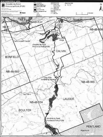
Enlarge Figure 3: Bear Management Areas map
Figure 4: Trap Line Areas
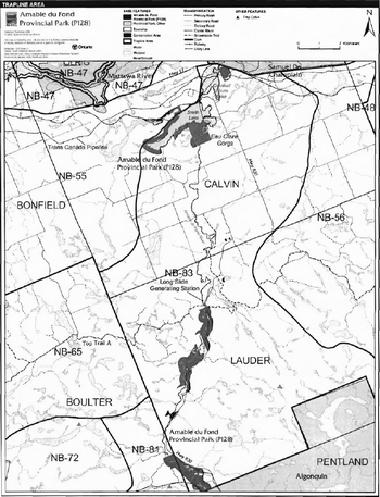
Enlarge Figure 4: Trap Line Areas map
Existing commercial fur harvesting operations may continue where the activity has been licensed or permitted since January 1, 1992. New operations, including trap cabins and trails, will not be permitted (OMNR 2000; 2003b).
Transfers of active trap line licenses are permitted, subject to a review of potential impacts and the normal transfer or renewal conditions that apply.1
5.1.3 Industrial resources
There are no existing mining claims within the park. Mining and surface rights on all lands within the park have been withdrawn from staking under the Mining Act (1990). Mineral exploration and mineral extraction are not permitted in the park (OMNR 1992).
In accordance with Ontario’s Living Legacy Land Use Strategy (OMNR 1999), however, access in the park to mining lands (i.e. forest reserves and mining patents) will be permitted for purposes of mineral exploration, development or operations. Access will be planned in accordance with the requirements of the Environmental Assessment Act.
Two abandoned pits and part of one inactive reserve pit occur within the park in Lauder Township (R. Labreche, personal communication, November 16, 2006). Aggregate extraction is not permitted inside the park (OMNR 1992; 2004a). Should the inactive reserve pit located in Lots 31 and 32, Concession 6 be reactivated, conditions in the reactivation of the permit will include a requirement to rehabilitate the lands that are now within the park and there would be no extraction within 120 metres of the park boundary. Use and maintenance of the existing road will be permitted to continue as long as the pit is required; however, a gate will be established at the entrance of the road from Highway 630. This road will be discontinued and rehabilitated as part of the closure of the pit. The reissue of this inactive reserve pit in Lauder Township will meet the requirements of A Class Environmental Assessment for Provincial Parks and Conservation Reserves.
5.1.4 Access and crossings
Access - roads
Amable du Fond Provincial Park can be reached by water and land.
Highway 630 passes between Smith and Crooked Chute lakes and runs parallel to the Amable du Fond River for much of its length. This highway provides both direct access to Amable du Fond River Provincial Park, as well as access via existing tertiary roads. Tertiary road access includes:
- A dirt road, on the west side of Highway 630 and to the north of Algonquin Provincial Park, to the southeastern side of the park.
- Another tertiary road on the west side of the waterway crosses through the park. This road has been used for forestry purposes to access cut blocks outside the park (M. Verwey, personal communication, November 15, 2006).
- A small portion of tertiary access road located between the two existing LUPs in the middle section of the park.
- A tertiary road, along the edge of Crooked Lake, into the northern-most part of the park.
- Smith Lake is accessible via a tertiary road named Suzanne’s Road. A small picnic area with a boat ramp and dock is maintained here by Calvin Township. The picnic area is located on Buckeye Bay, the easternmost bay of Smith Lake.
Highway 630, located to the south ofTrans Canada Highway 17, provides access to Amable du Fond Provincial Park and into Kiosk, which is located within Algonquin Provincial Park.
Where existing forest access roads are essential for continued access within or beyond the park for forest management, recreation or in-holding purposes, and alternative road access does not exist, or road relocation is not feasible, existing roads will continue to be available for access. Continued use will include maintenance and may include upgrade (OMNR 2004a). Ontario Parks is not responsible for the maintenance or upgrade of any roads within the park boundary.
Any proposed development, maintenance or upgrading of existing roads must meet all requirements of the Environmental Assessment Act.
Aggregate resource extraction is not permitted within parks. An external source of aggregate is required for road improvements and maintenance.
Railway
Railway line corridors have been excluded from the boundary of the park however, they may provide some access to the site. An abandoned Canadian National Railway (CNR) corridor passes through the southwestern part of the park while the Canadian Pacific Railway (CPR) line runs adjacent to the northern boundary of the site. Trespassing is prohibited along the CPR line.
Utility Corridors
A hydro corridor runs through the park in Lauder Township. This corridor is managed by the MNR through a province-wide LUP issued to Hydro One.
The Trans Canada Pipeline crosses through the park in Calvin Township, to the northeast of Crooked Chute Lake. A 30 metre wide easement area exists along the length of the pipeline in this section of the park.
The maintenance of the existing utility lines will be permitted. Maintenance activities must adhere to the regulations set out under relevant acts, such as the Environmental Assessment Act, the Canadian Environmental Protection Act (1999), and the Pesticides Act (1990) and shall not negatively impact the values being protected within this park.
All public utilities (e.g., gas pipelines, transmission lines, communications towers) must avoid park lands wherever possible. New utility corridors may be necessary to maintain essential public services (OMNR 2004a).
Any future utility corridors proposed through the park, where park lands are unavoidable, will be reviewed on a case-by-case basis. Protection of park features and values will be priority and all requirements of the Environmental Assessment Act will be met.
Recreational Trails
Canoe Route: Amable du Fond River contains a canoe route; however, it receives little use. Low summer water flows, unmaintained portages, and an abundance of private property along the route discourage travel along this river.
Snowmobile: TOP Trail A occurs through the middle section of the park. Existing use will be permitted to continue unless there are significant demonstrated conflicts, in which case the MNR will revaluate the situation and may redirect or eliminate this use.
Other Trails: There are currently no other authorized recreational trails within the park boundary. New trails (e.g., hiking) may be developed if the need arises. Any proposed development within the park is subject to Environmental Assessment Act requirements.
5.1.5 Adjacent land management
Forestry
Amable du Fond River Provincial Park is surrounded by the Nipissing Forest Management Unit Forest operations in his unit is managed according to the 2004-2024 Forest Management Plan for Nipissing Forest (G. Thauvette, personal communication, November 8, 2006).
Eau Claire Gorge Conservation Area
The Eau Claire Gorge Conservation Area (CA) consists of 120 hectares of land and water. The property was purchased by the North Bay-Mattawa Conservation Authority in 1976 to preserve the distinctive natural and historic features of the area. The conservation area abuts with the park on the south side of Smith Lake. Eau Claire Gorge CA contains a 1.9 kilometre interpretive trail.
Provincial parks
Samuel de Champlain Provincial Park is located to the northwest of Amable du Fond River Provincial Park, on the north side of Highway 17. Samuel de Champlain Provincial Park is situated in the valley of the historic Mattawa River, a historic travel route for Aboriginal people, explorers, and voyageurs. The park also includes a learning center that provides educational programming and conducts research about ecosystems and sustainable management in the Mattawa valley and district.
Algonquin Provincial Park is located directly south of Amable du Fond Provincial Park. Algonquin Provincial Park protects various natural and recreational features and also contains numerous historic and archaeological resources. Algonquin Provincial Park provides interpretive information about the area and has inspired more than 40 books, 1,800 scientific papers, a dozen films, a symphony, and the art of Tom Thompson and the Group of Seven.
5.1.6 Land disposition
Amable du Fond Provincial Park is located in Lauder and Calvin townships in MNR's North Bay Administrative District.
New land disposition for the private use of individuals or corporations will not be permitted (OMNR 1992; 2000).
Land Use Permits. Licenses of Occupation, and Unauthorized Occupations
There are three LUPs within the park, in Lauder Township. Two of the permits are issued for private recreation camp use. The third permit is a province wide permit issued to Hydro One for the hydro line which runs parallel to Highway 630 in Lauder Township.
Existing authorized LUPs for recreation camps may be eligible for enhanced tenure but not the purchase of land. Recreational camp LUPs cannot be changed to commercial LUPs unless this is supported during a review as part of park management planning. Enhanced tenure, is defined as a possible extension of the term of the LUP for recreation camps up to 10 years or upgrade in tenure (i.e., LUP to lease) (OMNR 2000a).
Enhanced tenure for an LUP for a recreation camp is not guaranteed. Requests for enhanced tenure, or to transfer recreation camps, will be reviewed based upon the following criteria:
- Continued compliance with the conditions of the LUPs for recreation camps.
- Current land disposition policies for LUPs.
- Consistency with park objectives to sustain values - no effects on heritage values and/or conflict with other uses.
- Consistency with Aboriginal land claim negotiations or protocol agreements.
- All rents, taxes, fees, rates or charges are paid and in good standing.
An extension in the term of tenure for an existing private recreation camp LUP does not convey a commitment to provide for a change in the type or the standard of existing access to the private recreation camp.
The Trans Canada pipeline runs through a portion of the park in Calvin Township. A 30 metre wide easement area exists along the length of the pipeline in the park.
There are no known licenses of occupation or unauthorized occupations within the park.
Patent land
Private lands are not included in the park and, as such, the policies and legislation of the Provincial Parks Act do not apply.
Boat caches
There are no known authorized boat caches located within the boundary of Amable du Fond River Provincial Park. Boats are not permitted to be left unattended in the park without written permission from the superintendent under the authority of the Provincial Parks Act.
5.2 Aquatic ecosystems
Sustaining quality water resources is integral to the protection of park and adjacent land values. The MOE enforces applicable legislation and regulations for water quality.
5.2.1 Water management
There are no existing water control structures within Amable du Fond River Provincial Park.
The Long Slide generating station is located on the Amable du Fond River just outside the middle section of the park. This generating station has a one kilometre zone of influence, which encompasses a portion of the park and may affect existing water flows and levels. This run-ofthe-river facility has minimal storage capacity and contains turbines that vary with the natural flow of the river. This facility is operated through a "simple" water management plan. Park values should be considered during the water management planning process.
New commercial hydroelectric development will not be permitted in the park (OMNR 2000).
5.2.2 Fisheries management
Fisheries management will complement the maintenance and enhancement of native, selfsustaining fish populations.
Spring-fed brooks along the river serve as nursery grounds to support the brook trout population within the Amable du Fond River. Smith and Crooked Chute lakes produce a variety of warm water game fish, such as northern pike, walleye, and small mouth bass.
Sport fishing
Sport fishing is permitted within the park. This activity is governed by legislation and regulations in the Fish and Wildlife Conservation Act (1997) and the Fisheries Act (1985). The Recreational Fishing Regulations Summary contains details on regulations which are applicable to this area.
Commercial fishing
There are no commercial fishing operations within the park. New operations will not be permitted (OMNR 2000).
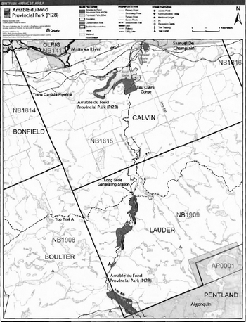
Commercial baitfish harvesting
There are three commercial baitfish harvesting licenses allocated in Calvin, Boulter, and Lauder townships (NB1815, NB1908, NB1909). Existing commercial baitfish harvesting may continue where the activity has been licensed or permitted since January 1, 1992. This activity may be subject to conditions identified through future park management planning or fisheries management plans. New baitfish licenses will not be permitted (OMNR 2000; 2003b).
Fish stocking
The stocking of native fish species may be considered through park management planning, with full public and Aboriginal consultation. Non-native fish species will not be deliberately introduced into park waters (OMNR 1992).
6.0 Operations policies
6.1 Recreation management
Future planning with full public and Aboriginal consultation will review direction on motorized and non-motorized recreation activities.
6.1.1 Motorized recreation
Motorboats
The use of motorboats is permitted to continue, unless park values are threatened (OMNR 2004a).
Aircraft
Aircraft landings are permitted in the park (OMNR 2004a). All aircraft landings are subject to regulation and valid aircraft landing permits issued by the park superintendent under the authority of the Provincial Parks Act.
Snowmobiles
The authorized Ontario Federation of Snowmobile Clubs (OFSC) Trans Ontario Provincial Series (TOP) trail "A" crosses over the river just north (outside) of the park boundary and into the eastern corner of Amable du Fond Provincial Park in Lauder Township.This small section is the only existing authorized section of snowmobile trail in the park. Existing use will be permitted to continue unless there are significant demonstrated conflicts, in which case the MNR will revaluate the situation and may need to redirect or eliminate use.
Snowmobile use on established routes for access to private land in-holdings, LUPs, and recreational ice fishing may be permitted to continue unless such trails threaten park features and values, create user conflicts or raise safety/liability issues.
Proposals for new trails may only be considered through future planning with public and Aboriginal consultation (OMNR 2000).
Off-trail snowmobile use is not permitted.
All-terrain vehicles
Authorized ATV trails are permitted to continue (OMNR 2004a); there are none in this park.
The use of ATVs on existing trails for access to private land in-holdings and LUPs is permitted to continue unless park values are threatened. Proposals for new trails may only be considered through future planning with public and Aboriginal consultation (OMNR 2000).
Figure 5: Commercial Baitfish Areas
Enlarge Figure 5: Commercial Baitfish Areas map
Unauthorized trail use by ATVs is not permitted. MNR district and Ontario Parks will work to discontinue this unauthorized use in the park.
6.1.2 Non-motorized recreation
Camping
There are currently no developed camping facilities within Amable du Fond River Provincial Park. Some unmanaged campsites that are used in conjunction with the canoe route and road access.
Ontario Parks may assess the condition of existing campsites and will maintain, rehabilitate, or close sites as required. If there is an identified need, new campsites may be considered (OMNR 2004a). Infrastructure will be permitted in order to protect park features and values in response to use, environmental deterioration and environmental protection requirements. Any proposed development in the park must fulfill the requirements of the Environmental Assessment Act.
Hiking
There are no designated hiking trails in Temagami River Provincial Park.
If there is an identified need, the development of new hiking trails may be considered. Trail infrastructure to protect park values and features will be permitted. Any proposed development within the park is subject to Environmental Assessment Act requirements.
Canoeing kayaking
Existing uses may continue, unless park values are threatened (OMNR 2004a). Infrastructure to protect park features and values may be permitted and developed in response to use, environmental deterioration, and environmental protection requirements.
6.1.3 Emerging recreational uses
There are emerging recreational uses for which there is limited or no policy to deal with their management (e.g., adventure racing, geocaching). The park superintendent will use legislation, policy and guidelines that are in place to manage emerging uses.
6.2 Development
There is no existing infrastructure located within park boundary. Infrastructure to protect park features and values may be permitted and developed in response to use, environmental deterioration and environmental protection requirements. Any proposed development within the park is subject to MNR's requirements under the Environmental Assessment Act.
6.3 Commercial tourism
There is no commercial tourism infrastructure within the park. New commercial tourism facilities may be considered, if they are consistent with park policy (OMNR 2004a). Any development must meet the requirements of the Environmental Assessment Act.
7.0 Cultural resources
An assessment of the cultural resources specific to Amable du Fond River Provincial Park has not yet been completed. The management of any cultural values within this park will be directed toward protection and heritage appreciation (OMNR 1992).
Amable du Fond River Provincial Park Interim Management Statement - 2006
8.0 Heritage education
Literature and other supporting information may be developed to describe the park in the context of Ontario’s provincial park system. Boundary limits, significant heritage features and permitted uses of the waterway park may be included in park literature.
Prospective park visitors may be informed about the sensitivity and significance of park values through park literature.
9.0 Research
Scientific research by qualified individuals which contributes to the knowledge of natural or cultural history, or to environmental or recreational management, may be encouraged in the park. Ontario Parks will encourage institutions, such as universities, to undertake research projects.
All research programs will require the approval of Ontario Parks and are subject to park policy and other applicable legislation. Any materials removed from the park will remain the property of Ontario Parks.
Approved research activities and facilities will be compatible with the park’s protection objective. Any site which is affected by research will be rehabilitated as closely as possible to its original state. Environmental Assessment Act requirements will apply.
10.0 References
Canadian Environmental Protection Act, 1999.
Environmental Assessment Act, 1990.
Fisheries Act, 1985.
Fish and Wildlife Conservation Act, 1997.
Frey, E. and D. Duba., 2002. Earth Science Checksheet- P128 Amable du Fond River Provincial Park. Ontario Ministry of Natural Resources (OMNR).
Harding, D., 2002. Amable du Fond River Provincial Park Recreation Inventory Report-Version OMNR.
Migratory Birds Convention Act, 1994.
Mining Act, 1990.
Morris, E. R., 2002. Natural Heritage Area Life Science Checksheet Amable du Fond River (OLL P128). OMNR
Ontario Ministry of Natural Resources, 1974. A Topical Organization of Ontario History. Historic Sites Branch Division of Parks.
Ontario Ministry of Natural Resources, 1992. Ontario Provincial Parks Planning and Management Policies.
Ontario Ministry of Natural Resources. 1999. Ontario’s Living Legacy Land Use Strategy.
Ontario Ministry of Natural Resources, 2000. Ontario’s Living Legacy Land Use Strategy (Policy Clarification).
Ontario Ministry of Natural Resources, 2003a. Public and Aboriginal Consultation Document Form Ontario’s Living Legacy Protected Area Boundary Refinement Review: Amable du Fond River Provincial Park (P128).
Ontario Ministry of Natural Resources, 2003b. Directions for Commercial Resource Use Activities in Provincial Parks and Conservation Reserves. 5 pp.
Ontario Ministry of Natural Resources, 2004a. Crown Land Use Policy Atlas.
Ontario Ministry of Natural Resources, 2004b. Forest Fire Management Strategy for Ontario. Aviation and Fire Management Branch.
Ontario Ministry of Natural Resources, 2005. A Class Environmental Assessment for Provincial Parks and Conservation Reserves.
Pesticides Act, 1990.
Provincial Parks Act, 1990.
Appendix A: Background information
| Name | Amable du Fond River Provincial Park (P128) |
|---|---|
| Classification | Waterway |
| Ecoregion/Ecodistrict | 5E-5, 5E-10 |
| OMNR Administrative Region/District | Northeast - North Bay |
| Total Area (ha) | 731 |
| Regulation date and Number | June 2003 (O. Reg. 210/03) |
Representation
Earth Science: The park is in the northern part of the Ontario Central Gneiss Belt of the Proterozoic Grenville Province. Geological environments are part of the complex events of the mid-Proterozoic Grenville orogeny. The Grenville Province is the product of the thrust faulting of the Earth’s crust to the northwest as it collided with a continental landmass to the southeast.
Amable du Fond River is the remnant of a short-lived drainage of glacial Lake Algonquin into the Mattawa River valley. Representation of this surficial geology is regionally significant within the Ontario Parks system.
Life Science: This park is located within Ecodistricts 5E-5 and 5E-10. This discontinuous park offers a degree of protection to the waterway from Kiosk to Samuel de Champlain Provincial Park. Although it is small, it is moderately diverse. The black spruce-white cedar swamp upstream and Smith Lake wetland complexes contribute to the species richness of the park.
The riparian wetland complex near the Algonquin Provincial Park boundary includes a diverse assemblage of riparian vegetation types in a relatively small area.
Cultural Resources: The cultural values specific to Amable du Fond River Provincial Park have not been studied. The Amable du Fond River gets its name from an Algonquin chief that settled in this area. Aboriginal artefacts have also been discovered in this area.
Recreation and Tourism: The park is divided into three sections by adjacent private land. Canoeing can occur through all three sections which are linked by an established canoe route; the route is demanding, with many rapids, falls and a short season of use due to low water flows. Boating occurs on Smith and Crooked Chute lakes. Fishing is a popular activity associated with boating on these lakes.
Other recreational activities include hunting, landscape/wildlife viewing, snowmobiling, and all terrain vehicle (ATV) use.
There are no existing commercial tourism facilities within this park.
Inventories
| Survey Level | Earth Science | Life Science | Cultural | Recreational |
|---|---|---|---|---|
| Reconnaissance | Frey and Duba, 2001 | Morris 2002 | Required | Harding 2002 |
1 Transfers include situations where a license is surrendered with a request that it be immediately reissued to another individualor organization that is assuming an existing operation. Trap cabins are considered part of a trapline and would be transferred with the trapline for the purposes of trapping. If a trapline license is revoked or surrendered, all portions of the registered line within the park will be rescinded from the legal description of the trap line (OMNR 2003).