Arrow Lake Provincial Park Management Statement
This document provides direction on the management of Arrow Lake Provincial Park.
Regional Director’s Approval Statement
Arrow Lake Provincial Park
This revised Interim Management Statement will provide interim direction for the management of the above Provincial Nature Reserve until a comprehensive Park Management Plan is prepared.
This statement will provide the basis for the subsequent preparation of the Park Management Plan.
I am pleased to approve this Interim Management Statement.
Signed by:
M.S. Millar
A/Regional Director
North Central Region
Revised March 1991
Background Information:
| Name | Arrow Lake |
|---|---|
| Class | Recreation |
| M.N.R. District | Thunder Bay |
| M.N.R. Region | North Central |
| Total Area (ha) | 430 |
| Land & Water | |
| Site Region | 4W |
| Site District | 2 |
| Date in Regulation | October 19, 1985 |
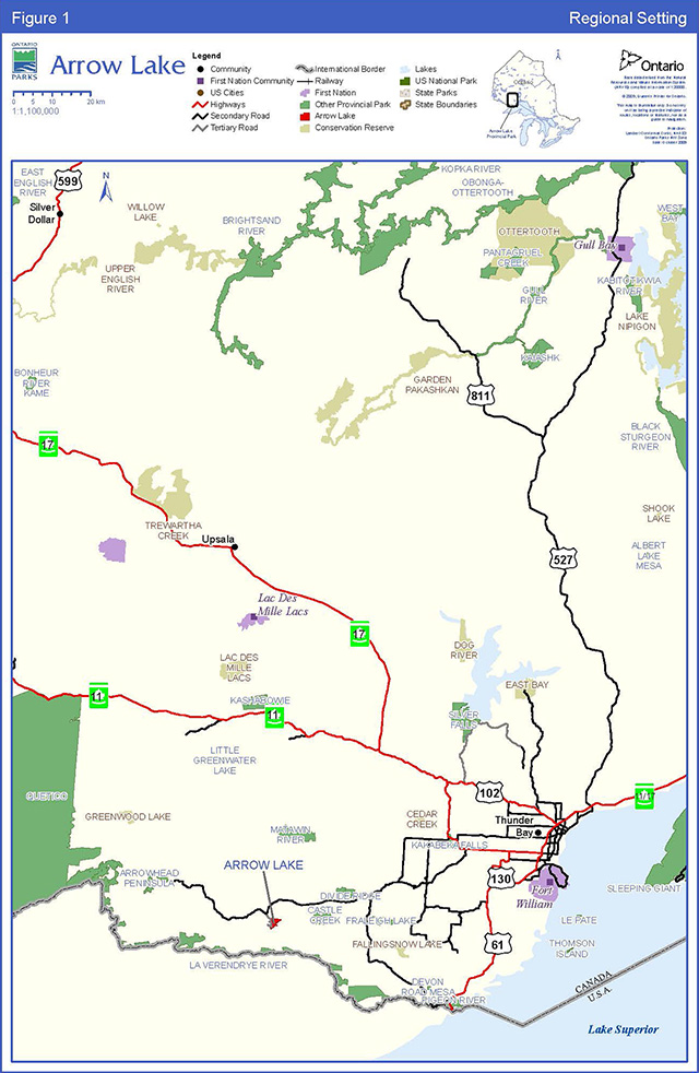
Enlarge Figure 1 - Regional Context
Life Science Representation
| Site Type/Landscape Unit | Species/Communities |
|---|---|
| Weakly to strongly broken shallow sandy till over proterozoic bedrock (Mesa-Cuesta). |
Earth Science Representation
| Geological Theme | Feature |
|---|---|
| Glaciofluvial | Outwash deposits (local significance) |
Cultural Resource Representation
| Theme | Theme Segment |
|---|---|
| N/A | N/A |
Recreation Opportunities
| Day Use | Car Camping | Wilderness/Back Country |
|---|---|---|
| N/A | N/A | N/A |
Inventories
| Level/Type | Reconnaissance/Completion Date | Detailed/Completion Date | Required? |
|---|---|---|---|
| Life Science | Checksheet December 1972 | LaVerendrye Inventory 1975 | |
| Earth Science | Checksheet February 1978 | LaVerendrye Inventory 1975 | |
| Cultural | Detailed Inventory | ||
| Recreational | |||
| Other |
Arrow Lake Provincial Park Interim Management Statement
I Land Tenure
All land within the Park is Crown Land.
Guideline:
Granting of tenure will not be considered for any land within the Park.
II Land Acquisition/Disposition
There is one private cottage subdivision which is located adjacent to the west boundary of the Park. (The names and addresses of cottage owners are on file in the Thunder Bay District Office.)
Guideline:
No consideration will be given to acquiring additional land or disposing of land within the Park until a Management Plan is completed.
III Existing/Proposed Development
Presently, the existing development within Arrow Lake Provincial Park includes:
| Campsites | 40 |
|---|---|
| Earth Pit Privies | 10 |
| Day Use Area | 1 |
| Boat Launching Ramp | 1 |
| Car Parking Area (20 vehicles) | 1 |
| Public Road | 2 km |
Outside the Park boundary, on Arrow Lake, there exists one control dam which is maintained by the M.N.R.
There is no proposed development at the present time.
Guideline:
Additional road development will not be permitted.
Local cottage owners will continue to access their properties through the Park.
The present use of the Park’s boat launch and parking area by cottagers, in order to access their properties by boat, will continue. (The names and addresses of the cottage lot owners that require access to their properties through the Park are on file in the Thunder Bay District Office.)
The M.N.R. will continue to monitor and regulate the water level of Arrow Lake at the control dam site.
Development (excluding that related to public health and safety) will not be undertaken prior to completion of a Management Plan.
The boundaries for this Park will be surveyed and cut, and appropriate signage provided, if funding permits.
IV Recreational Activities
Arrow Lake Provincial Park is classified as a Recreation Park.
The Park is located in an area known locally as the Northern Light corridor, which has high public use for many recreational activities. The Park is used primarily as a camping area.
The camping use from Victoria Day to Labour Day is estimated to be approximately 6,000 camper nights. There is additional day-use during July and August. (The Thunder Bay District Land Use Guidelines has targeted for 9,200 car camping opportunities for the Park.)
Rowdyism and vandalism have been a problem in past years, especially on holiday weekends. Enforcement has been provided jointly by the Ontario Provincial Police and M.N.R. Conservation Officers.
Guideline:
Recreational camping at Arrow Lake Provincial Park will be permitted to continue.
Sport fishing will be permitted within the Park.
Hunting will not be permitted within the Park.
Wildlife viewing will be permitted.
Enforcement to combat rowdyism and vandalism will continue as in the past. If unforeseen conflicts develop in the future (i.e., increase in rowdyism problem) necessary restrictions will be implemented.
V Commercial Activities
The Park comprises approximately 5% of trapline #106. (The trapline data is on file in the Thunder Bay District Office.)
The Park has been withdrawn from staking.
The Park area is identified to have medium potential for mineral aggregate extraction.
No other commercial activities presently exist.
Guideline:
Trapping, bait fishing, aggregate extraction, forestry and mining will not be permitted within the Park.
Other commercial activities will not be permitted.
Consideration will be given to allow private interest groups/individuals to operate/maintain the existing campground and related facilities.
VI Natural Resources
No earth/life science features have been identified in the Park.
Arrow Lake, adjacent to the Park, is identified as a prime Lake Trout lake.
Guideline:
Normal forest fire suppression will take place within the Park area.
Until appropriate measures are identified in a Management Plan, insects and diseases will be controlled as is deemed necessary.
VII Cultural Resources
Four known archaeological sites are found within the Park area. The southernmost point in the Park is believed to have been a major prehistoric encampment site.
Guideline:
Any disturbance of archaeological sites within the Park will be discouraged, and restrictions on activities on or near the sites will be implemented if necessary.
VIII Client Services
Internal Provincial Park signs are used to regulate use and to direct visitors to developed facilities in the Park.
No literature is presently available.
Guideline:
Signage will be maintained, if funding permits.
Client services will not be provided, except as required by legislation or M.N.R. policy.
IX Research and Inventories
Earth and life science inventory checksheets have been completed for Arrow Lake Provincial Park and are on file in the Thunder Bay District Office.
Guideline:
Additional research inventories will be encouraged to further document Park values. These may be carried out by M.N.R. or by outside interest groups/individuals. Any research must first be approved by the District Manager.
References/Sources
Noble, T.W. 1975. A Vegetational Survey of the Access Areas to LaVerendrye Wild River Park Reserve. Environmental Planning Series V1, 8 O.M.N.R.
Noble, T.W. 1977. Earth Science Inventory Checksheet. O.M.N.R.
Noble, T.W. 1978. (Unpublished Report) Life Science Inventory Checksheet. O.M.N.R.
O.M.N.R. 1983. Backgrounder Land Use Guidelines.
O.M.N.R. 1983. Thunder Bay District Land Use Guide.
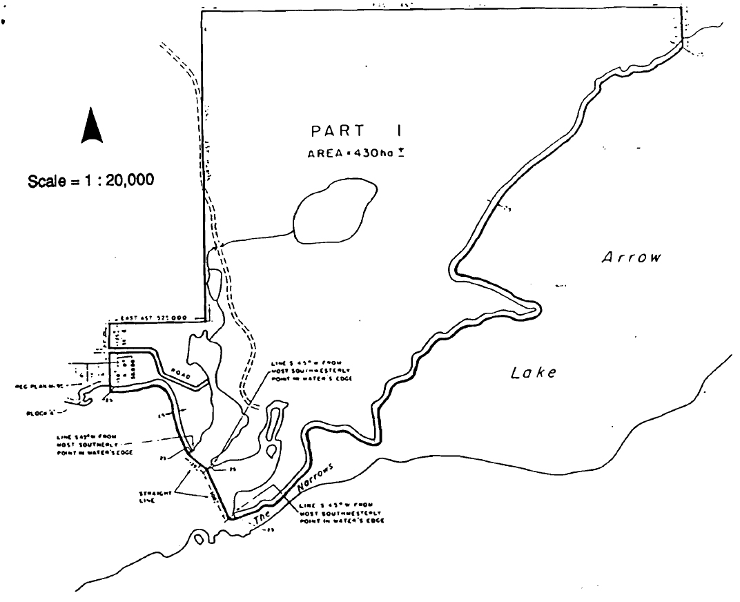
Plan of Arrow Lake Provincial Park in the District of Thunder Bay
![]()
Enlarge Plan of Arrow Lake Provincial Park in the District of Thunder Bay
Note: limits of the road forming the boundary of Arrow Lake Provincial Park are positioned 10,058 metres in perpendicular distance from the centre line of the existing roadway as constructed.
Note: park boundary is positioned 25 metres in perpendicular distance from the water’s edge along the shore of arrow lake unless otherwise show.