Arrowhead Provincial Park Management Plan
This document provides direction on the management of Arrowhead Provincial Park.
July, 2000
ISBN 0-07778-9629-X
© 2000 Government of Ontario
Additional copies of this publication are available from:
Arrowhead Provincial Park
RR# 3 Huntsville, ON
P1H 2J4
Tel:
Approval Statement
Arrowhead Provincial Park is a 1237-hectare Natural Environment class park, regulated in 1971. It was established to provide high quality outdoor recreation opportunities in an outstanding natural setting within the Muskoka tourist area, and serves as a destination summer and winter Activity Park. Arrowhead is situated within the Great Lakes – St. Lawrence forest region, and contains natural features of provincial significance.
The Management Plan for Arrowhead Provincial Park will guide the operation, management and development of the park over the next 20 years. The plan may be reviewed throughout its life span to address issues or changing conditions and the plan may also be amended as the need arises.
"I am pleased to approve the Arrowhead Provincial Park Management Plan as official policy for the management and development of this park. The plan reflects this Ministry’s intent to protect natural and cultural features of Arrowhead Park and maintain and develop high quality opportunities for outdoor recreation and heritage appreciation for both residents of Ontario and visitors to the Province."
Per
Adair Ireland-Smith
Managing Directions
Ontario Parks
Preface
The Ministry of Natural Resources (MNR) is responsible for managing Ontario’s natural resources in accordance with the statutes it administers. As the province’s lead conservation agency, the Ministry is the steward of provincial parks, natural heritage areas, forests, fisheries, wildlife, aggregates, fuel minerals, and Crown lands and waters.
In 1994 the MNR finalized its Statement of Environmental Values (SEV) under the Environmental Bill of Rights (EBR). The SEV is a document that scribes how the purposes of the EBR are to be considered whenever decisions that might significantly affect the environment are made in the Ministry.
The primary purpose of the EBR is to protect, conserve and, where reasonable, restore the integrity of the environment. The MNR has four objectives it’s SEV in relation to the purpose of the EBR: to ensure the long-term health of ecosystems by protecting and conserving our valuable soil, aquatic resources, forest and wildlife resources as well as their biological foundations; ensure the continuing availability of natural resources for the long-term benefit of the people of Ontario; to protect natural heritage and biological features of provincial significance; and to protect human life, the resource base and physical property from the threats of forest fires, floods and erosion.
Throughout the development of this Management Plan for Arrowhead provincial Park, the Ministry has considered its Statement of Environmental Values. This plan is intended to reflect the direction set in the SEV and to further the objectives of managing our resources on a sustainable basis.
1.0 Introduction
Arrowhead Provincial Park is located in the District Municipality of Muskoka on Highway 11, eight kilometres north of Huntsville (Figure 1). The Park first opened for camping in 1966, but was not formally established until 1971 with its designation under the Provincial Parks Act (Ontario Regulation 114/71). The Park is approximately 1237 hectares in size and contains two lakes. Its southern boundary abuts the north shore of the Big East River, which has its headwaters in Algonquin Park.
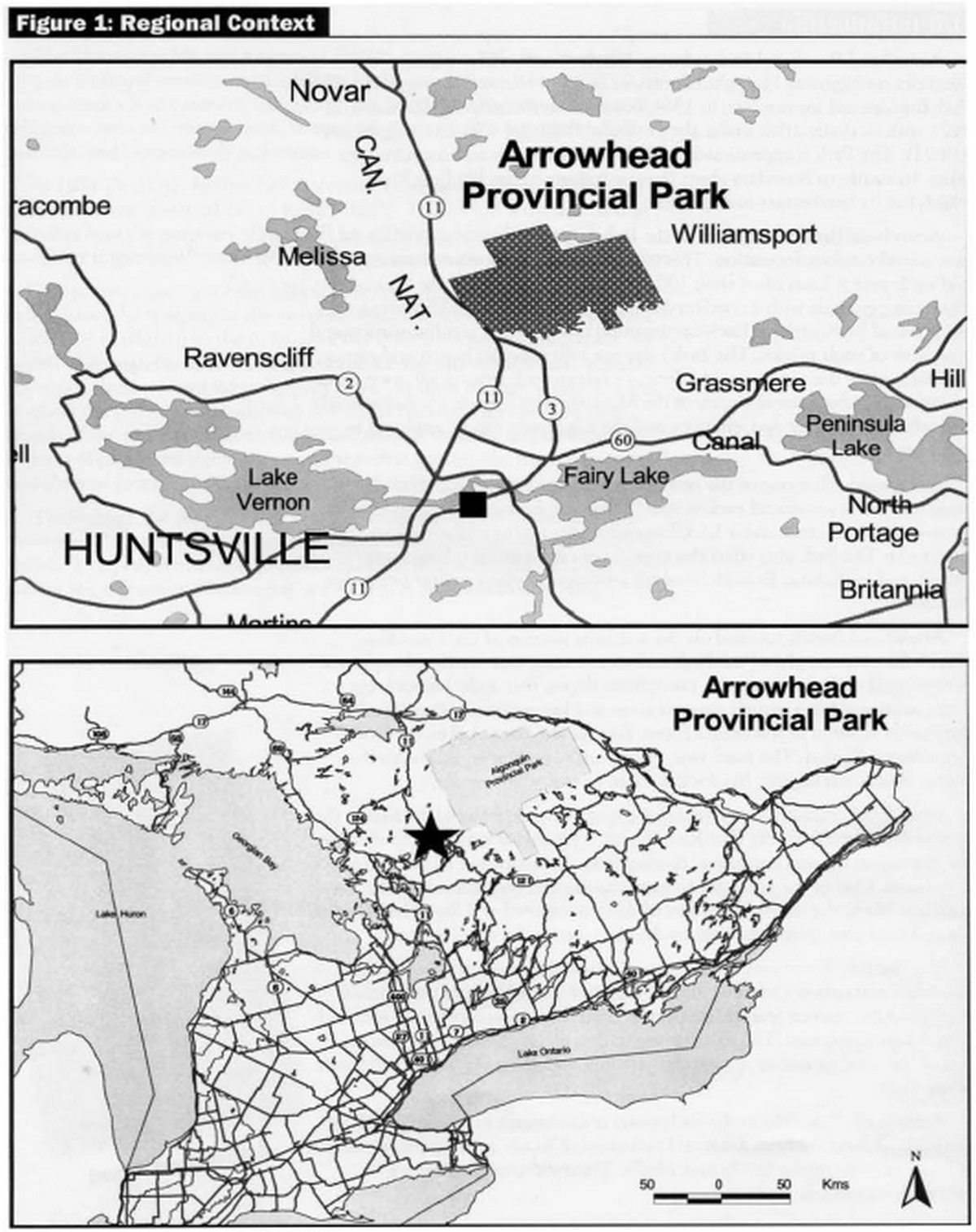
Arrowhead Park is in an area of the Province with a climate suitable for year-round outdoor recreation. This makes the Park a popular destination, and each year it hosts more than 100,000 visitors. In summer, the Park offers three campgrounds with a combined total of 388 campsites; 117 of these sites are serviced by electricity. Each campground has a central comfort station and a number of vault privies. The Park’s day use area provides beach and picnic facilities, while the extensive 14 kilometre hiking trail network allows visitors to experience the natural beauty of the Muskoka area (Figure 2). Arrowhead’s two lakes offer fishing opportunities and the waterways can be explored by canoe or kayak.
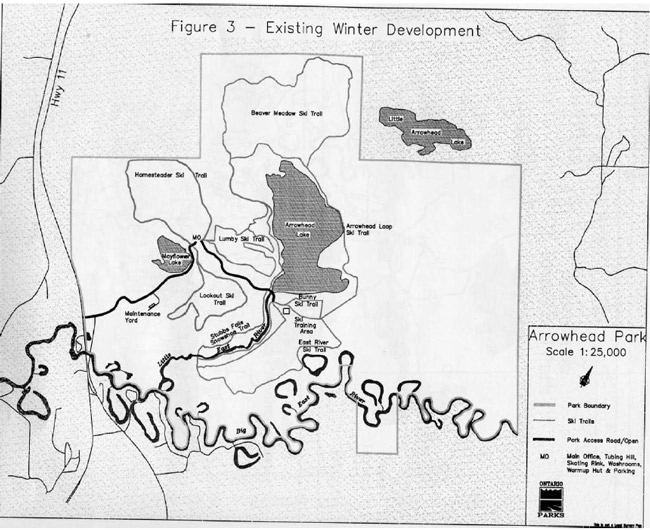
Arrowhead offers one of the best and most popular traditional winter programs in the provincial park system. There are presently 23 kilometres of cross-country ski trails and a 1.6 kilometre winter hiking and snowshoe trail (Figure 3). The Park also offers the opportunity for skating, tobogganing, tubing, and ice fishing. Reliable snowfall provides excellent winter recreation conditions.
Arrowhead Park is situated on the southern portion of the Canadian Shield. The topography of the Park and surrounding area typifies this portion of the shield with rough terrain, precipitous slopes, thin soils, bedrock out-crops, scattered lakes, poorly drained areas and beaver ponds. Ecologically, the Park is situated in the Mixed Forest Zone of the Great Lakes–St. Lawrence Forest Region. The main tree species are sugar maple, yellow birch, poplar, beech, white pine, hemlock, balsam fir and white spruce.
Arrowhead contains many interesting earth science features, including the provincially significant Big East River Delta. This glacial delta was formed by the deposition of sand and gravel flowing from the meltwater of glacial Lake Algonquin. One of the best sites to view this ancient formation is at Big Bend Lookout. Here, the inside of the glacial delta is exposed and layers or bands of silt and sand that were deposited by the glacial river are evident.
The Big East River cuts deeply through the delta, along with associated meanders and oxbow characteristics. This landform, which is a provincially significant life science feature, supports a complex community of riparian and sand-based vegetation. The existing vegetation includes species representative of the area, as well as species that are rare and generally found well south of the Park.
Arrowhead Park reflects the early years of settlement in Muskoka. Within the Park, abandoned farm fields and remnants of buildings are representative of homesteading in the 1870's and 1880's. These cultural features are regionally significant.
Figure 1 - Regional Context
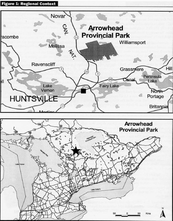
Enlarge Figure 1 - Regional Context
Figure 2 - Existing Summer Development
Enlarge Figure 2 – Existing Summer Development
Figure 3 - Existing Winter Development
Enlarge Figure 3 – Existing Winter Development
2.0 Classification
There are six classifications of provincial parks: Natural Environment, Nature Reserve, Wilderness, Recreation, Historical, and Waterway. Arrowhead is classified as a Natural Environment Park in recognition of its provincially significant landforms and associated plant communities, as well as its capability to provide a diversity of outdoor recreation activities in an attractive natural setting.
3.0 Park Goal
The goal of Arrowhead Park is:
To protect representative provincially significant natural, cultural and recreational environments; to provide a variety of outstanding recreation opportunities in a natural environment; to foster an appreciation of the natural and cultural values of the park.
4.0 Park Objectives
The four park objectives are:
4.1 Protection
The natural environment of Arrowhead includes representative landscapes containing provincially significant earth and life science features, and regionally significant historical sites. These values which include the bluffs at Big Bend Lookout, the oxbows and river flood plain, and the historical Lunt homestead, will be protected by appropriate zoning and management, and will be featured in the Natural Heritage Education program.
(To protect the provincially significant natural environment of Arrowhead Provincial Park, incorporating natural and cultural features)
4.2 Heritage Appreciation
Exploration and appreciation of Arrowhead Park will be encouraged and be compatible with, and complementary to, the protection of the natural and cultural resources of the Park.
Arrowhead offers four self-guided trails and a lookout, providing unstructured opportunities for visitors to learn about the significant natural and cultural features of the Park. Arrowhead also provides canoeing opportunities for exploration and appreciation of the waterways and associated natural features contained within the park.
The Natural Heritage Education program will provide information on the Park’s significant features and related environmental and historical themes to visitors through conducted hikes, evening programs, family and children’s programs, audio-visual presentations, leaflets and other means. Further details are contained in Section 8.1.
(To provide opportunities for unstructured individual exploration and appreciation of the natural heritage of Arrowhead Park.)
(To provide opportunities for the exploration and appreciation of Arrowhead’s natural and cultural environments through interpretation and education based on the character and the significance of the Park)
4.3 Recreation
Arrowhead offers a diverse range of day use opportunities. Winter facilities include a skating rink, toboggan and tubing hill, a snowshoe trail and an extensive network of cross-country ski trails designed to emphasize the natural beauty of the Park’s landscape. Snowmobiling is not permitted in the Park. Summer facilities include beaches, picnic areas, a pet exercise area and a hiking trail system. Recreation programs may be offered to teach canoeing and cross-country skiing skills.
The Park’s three campgrounds, Roe, East River, and Lumby, camping experiences focusing on solitude and personal integration with nature in a relatively undisturbed landscape.
(To provide day use opportunities in areas of outstanding recreational potential associated with the natural environment of the park)
(To provide facility-based camping opportunities in the natural environment of the Park associated with areas of outstanding recreational potential).
4.4 Tourism
Located on Highway 11 in northern Muskoka, Arrowhead Park plays an important role in the tourism market. The Park is highly accessible and attracts both day-users, living or vacationing in the area, and campers making Arrowhead their destination or stopover as part of a longer trip.
(To provide Ontario residents and out-of-province visitors with opportunities to discover and experience the distinctive region of the Park and its environs).
5.0 Park Boundary
The boundary of the Park is delineated by Ontario Regulation 111/93. In 1993, a number of land parcels were regulated under the Provincial Parks Act increasing the size of the Park from 963 hectares to 1237 hectares.
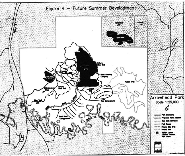
Three patented lots incorporating Little Arrowhead Lake (Figure 4) are identified as potential additions to the Park property. Should they be listed for sale, and if funding is available, the Ministry will consider the purchase of this land on a willing vendor, willing buyer basis. This extension will facilitate management, significantly enhance the Park’s recreational potential by allowing for the addition of ski trails, bike trails, or interior accommodations, and contribute to the achievement of protection and recreation objectives. Access to interior accommodations situated along Little Arrowhead Lake would be provided by an access road leading from Roe Campground to the lakeside interior sites. The access road will be incorporated into the cross-country ski trail network during the winter months.
Through evaluation and zoning, these acquired lands will be allocated to their most appropriate uses. If the three lots are purchased, Ontario Parks will seek to add the adjoining Crown lot (Lot 28 Concession IX) through an appropriate planning process that is consistent with Environmental Assessment Act requirements.
Figure 4 - Future Summer Development
Enlarge Figure 4 – Future Summer Development
6.0 Zoning
To fulfill the objectives of Arrowhead Provincial Park, lands within the Park are zoned on the basis of their significance for protection and their potential for recreation appropriate to a Natural Environment park. Specific policies for each zone are established for resource stewardship, development and management activities. More details are provided in Section 7.0.
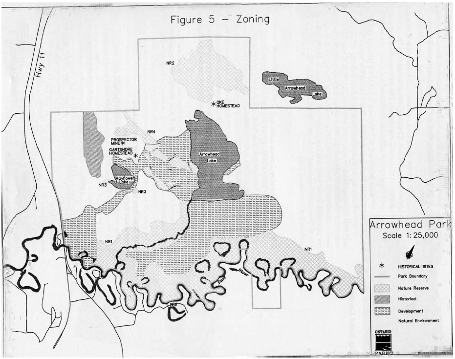
Natural Environment class parks may contain any of six types of zones: Access, Development, Natural Environment, Nature Reserve, Wilderness, and Historical. Four zone designations guide the management of Arrowhead: Development; Natural Environment; Nature Reserve; and Historical (Figure 5).
6.1 Development Zone (182 ha)
Development zones provide the main facilities and services for a range of day-use and car camping activities.
Development permitted includes campgrounds, trails, roads, washrooms, visitor control structures, commercial, administrative, management and Natural Heritage Education facilities.
This zone includes three existing campgrounds: Lumby, Roe and East River, and their associated facilities, day use areas, main roads and administrative facilities. All intensive facility development will be confined to this zone.
The Development zone, identified in the 1986 Management Plan, at the north end of Arrowhead Lake has been rezoned to Natural Environment. This zoning will offer an increased level of protection to natural features in the area by eliminating any potential for development, since intensive facility development is not feasible for this area. A new Development zone is situated along the east side of Arrowhead Lake to facilitate interior rustic accommodations. Access to this point will be provided by an access road based on an existing seasonal trail. This trail may be upgraded to a gravel road if necessary to support vehicular traffic, and in such case would be zoned as Access zone. A feasibility study and a site specific life sciences inventory will be conducted prior to any site development.
The Development zone has been expanded to accommodate relocation of the Park entrance. The new entrance road, once constructed, will be rerouted to follow the original road bed (old Highway 11) passing through the Park.
6.2 Natural Environment Zone (729 ha)
Natural Environment zones support low-intensity recreational use. Development permitted includes recreational trails, signs necessary for route identification, minimal interpretive facilities and temporary research and management facilities. While the primary focus of a Natural Environment zone is protection of flora and fauna, emphasis is placed on usage for high quality recreational and educational experiences, utilizing the natural elements within this zone.
Figure 5 - Zoning

Being the largest zone in the Park, the Natural Environment zone provides the land base for extensive recreational activities, and a buffer between the Development and Nature Reserve zones.
The portion of the park within Lot 25 Concession 6, situated south of the Big East River, has been re-zoned from Nature Reserve to Natural Environment. This zoning is more compatible with land uses on adjacent private land.
Both Mayflower and Arrowhead Lakes are situated within Natural Environment zoning. The existing low impact activities occurring on these water bodies conform to the values associated with a Natural Environment zone, which include high quality recreational and educational experiences. Some of the activities permitted on these water bodies include canoeing, kayaking and fishing. The use of motorboats is not permitted in the park, and swimming is not permitted in Mayflower Lake. The recommended swimming areas are the designated beaches located at the south end of Arrowhead Lake.
6.3 Nature Reserve Zones (306 ha)
Nature Reserve zones include significant life and earth science features requiring different management from lands in adjacent zones in order to protect these features. These zones are selected to represent distinctive natural habitats and landforms. The primary purpose of this zone is geared toward protection and heritage appreciation objectives. Monitoring programs will be developed for the systematic review of the impact and effectiveness of management policies. Development in these zones is limited to trails, necessary signs, minimal interpretive facilities and temporary research and management facilities.
Four Nature Reserve zones have been designated in Arrowhead Park to protect natural features for their intrinsic value, interpretation and scientific study (Figure 5).
NR1 Riparian Environments and Mature Hardwood Communities (233 ha)
This zone includes two sections. The first is the flood plain along the north shore of the Big East River. It contains 184 hectares of meandering features atypical of the Canadian Shield, and supports an interesting and diverse assemblage of plant communities and associated wildlife viewing opportunities.
Big Bend Lookout, located at the most northern "bow" of the Big East River within the Park, is composed of large sand bluffs exposing the inside of the glacial delta. The provincially significant delta was formed by the deposition of sediment from glacial rivers at the mouth of Lake Algonquin and extends over much of the East River and Roe Campgrounds. This small area (2 hectares) at Big Bend is of considerable scientific value. The slow erosion of the bluffs by the Big East River provides an interesting example of the response by primarily herbaceous plants to a constantly changing substrate.
The bluffs are very sensitive to human disturbance, which accelerates the erosion process. This area is a prominent asset of the Park and will continue to be treated with special attention. No development will be allowed except to protect this area’s significant features.
The second section of this zone contains mature hardwood forest stands established on the banks of the Little East River between Arrowhead Lake and the Big East River. This area consists of a provincially significant and relatively stable climax hardwood forest community, the oldest in the Park, and supports exceptionally rich flora including many southern plant species, such as Wild Leek, Christmas Fern and Toothwort. It has high interpretive value. Formerly, this section of the zone contained 12 hectares of this vegetation community. However, since publication of the Park Management Plan of 1986, an additional study of life science features has recommended the zones expansion to include sand-based submature to mature late successional deciduous forest of the Nature Reserve as well as the regionally significant southern flora on the slopes and ravine tops. As a result, 37 hectares will be added to this zone.
NR2 Beaver Meadow (52 ha)
This wetland supports an unusual diversity of plant communities and animal habitat representative of the region. The beaver meadow area consists of a sphagnum bog and cattail marsh, and is one of the best wildlife and bird watching areas in the Park. This zone provides excellent opportunities for interpretation.
The Beaver Meadow Nature Reserve zone has been expanded, encompassing a broader range around the meadow; therefore, offering a greater zone of protection for significant plant communities and animal habitat.
NR3 Mayflower Lake Drainage Systems (1 ha)
This small watershed includes an inlet stream and an outlet stream to Mayflower Lake. This zone supports wetland habitats and breeding areas for reptiles and amphibians, including regionally rare species such as the pickerel frog and the regionally uncommon northern two-lined salamander. This zone is extremely sensitive to disturbance and should be subjected only to low intensity interpretation use, or off-site interpretation.
NR4 Lumby Valleys (20 ha)
These depressions consist of two ravines of moist lowland habitat, supporting a forest dominated by yellow birch, balsam fir and a lush herbaceous growth of violets, ferns and mosses. It is representative of a lowland forest and demonstrates the dramatic effort of topography and microclimate. The ravines will remain undisturbed and will be subject only to low intensity interpretation use. These valleys were evaluated, surveyed and flagged in 1996 with a net increase in size to perpetuate the values being protected. In addition, the zone boundary has been extended to include the wetland headwaters for the stream draining the northern-most valley.
6.4 Historical Zone (20 ha)
This zone contains features of historical and botanical interest associated with the Lunt homestead, circa 1880-1920. The old foundations, implements, stone walls and remaining cultivars such as rhubarb, apple and rye are representative of the historical segment, "Government Sponsored Settlement of the Shield Area in Muskoka-Parry Sound Area" as described in The Topical Organization of Ontario History. The site is regionally significant and has good interpretive value. The Homesteader’s Trail provides access to this zone for interpretive purposes.
The Historical zone has been expanded to include remaining evidence of the Lunt homestead, such as foundations, remaining clearings, and early successional growth forest where agricultural fields once existed. These fields, forest vegetation, and structure remnants may be managed in a manner that restores and reconstructs the cultural landscapes and features to more closely resemble their past condition.
There are also several sites of significant historical interest located throughout Arrowhead. These include the Gartshore Homestead site, an abandoned prospector mine, and the site of a root cellar from the Oke Farm. Any activities occurring on these historic sites will conform to the values typical of a historical zone. Research on these sites will be encouraged.
7.0 Resource Stewardship Policies
The Park’s natural and cultural features will be managed in accordance with the general planning and management policies for Natural Environment class parks. The following are specific directions to meet the special requirements of Arrowhead with each representing one component of the resource base. Although the policies are presented in separate categories, all subsequent planning and management will recognize the need to integrate these components since they are interrelated.
7.1 Vegetation
All vegetation management will be undertaken solely in support of objectives related to visitor safety, aesthetics and perpetuation of the natural and cultural values of Arrowhead Park. In the event that standing trees are to be cut during development or vegetation management, the Park Superintendent will oversee cutting operations.
A vegetation management strategy is required. The strategy will meet the diverse management needs specific to the Park and provide direction to staff The strategy will be prepared in conjunction with Park and other Ministry staff and outside experts as required, and in consideration of the prescriptions for each zone as outlined below.
In the Development zone, vegetation management will be undertaken:
- to rehabilitate areas devoid of natural regeneration
- to selectively remove diseased or dying poplar
- to maintain vegetation cover in the beach area and day use areas in an open park-like setting with tall trees, little understory and a scattering of open areas; and
- to perpetuate the values being protected in adjacent Nature Reserve zones
In the Natural Environment zone, natural succession will progress unimpeded. Where safety hazards exist along trails, dangerous trees will be removed in association with "brushing" operations and routine trail maintenance.
Controlled vegetation along the hydro line corridor, situated in the Natural Environment and Nature Reserve zones, will be hand tended. Chemical herbicide sprays will not be applied in the Nature Reserve zone.
In the Historical zone, the existing open field pattern will be maintained for interpretive purposes and consideration will be given to removing young saplings established on some previously unwooded areas. Research will be undertaken to determine the species composition of the surrounding forest at the time of settlement, and the forest will be managed to approximate those conditions.
In Nature Reserve zones, natural succession will be allowed to progress unimpeded.
The vegetation management plan will include strategies to control and eradicate non-native and/or noxious weeds (e.g. purple loosestrife). Controls will be directed as narrowly as possible to the specific pest, minimizing effects on the surrounding environment. Biological control rather than chemical control will be relied on whenever possible.
7.2 Wildlife
Sport hunting and commercial trapping are not permitted in the Park. Management trapping to control nuisance animals will be permitted under Ministry supervision in order to maintain existing water levels and perpetuate life science features in the Beaver Meadow and Mayflower Lake drainage system.
7.3 Earth Science Features
Arrowhead Park contains earth science features of provincial significance; however, no recent scientific studies of these features have been done since 1972. There is a need to reevaluate the earth science features, particularly those in areas of the Park that have been regulated since 1972. An Earth – Sciences Inventory will be conducted for the Park, which will provide an up-to-date interpretation of the formation of glacial deltas and Arrowhead’s place in the Lake Algonquin story. This new inventory may result in changes to the zoning configuration as documented in this plan. If necessary, a minor amendment to the plan will be prepared to address changes in zoning. The new inventory will provide the Park’s Natural Heritage Education staff with current information about earth science features to incorporate into the interpretive program.
The bluffs at Big Bend are one of the most significant features of the Park, but human recreation use is destroying the feature by accelerating erosion and by destroying the exposed bands of the glacial delta. Efforts to protect this feature include:
- maintaining a viewing platform to discourage people from running down the bluffs; and
- placement of an interpretive display explaining the significance of this feature from a geological and ecological perspective to foster an appreciation of the natural values being protected
7.4 Aggregate Resources
Sand or other aggregate material required for maintenance and capital improvements will be brought in from an external source. No new aggregate pits will be established within the park.
7.5 Fires
Given the size of the park, capital investment in facilities within the park, and the degree of structural development adjacent to the park, natural and human-caused fires in all zones will be suppressed. Fire suppression techniques which have the least residual impact on the park’s natural environment will be utilized whenever possible.
7.6 Insects and Disease
Measures to control insects and disease will be permitted in all zones where aesthetic or natural values are threatened. Where control is desirable and feasible, it will be directed as narrowly as possible to the specific threat to minimize the effect on other elements of the park environment. Biological rather than chemical controls will be used whenever possible. If required, control measures will be prescribed in the Vegetation Management Plan.
7.7 Fisheries and Lake Management
The put-and-take brook trout and rainbow trout fishery in Mayflower Lake will be continued.
A fisheries management plan will be prepared to:
- ascertain if the stocking program for Mayflower Lake can be intensified
- provide better angling opportunities on Arrowhead Lake through supplemental stocking
Ice fishing is permitted on both lakes during regular rainbow and brook trout fishing season. No fishing huts or fires will be allowed on the ice.
As specified in the Provincial Parks Act, no person shall operate a powerboat in the waters of Arrowhead Park.
Swimming is prohibited in Mayflower Lake.
8.0 Operations Policies
A Park Operating Strategy will be reviewed annually and updated as required to provide park staff with information to operate the Park on a day-to-day basis. In addition to addressing the operations policies, which follow, the strategy will include such topics as budget, staffing, and maintenance schedules, enforcement and emergency services. The strategy will be consistent with the approved Ontario Provincial Parks Operating Standards.
8.1 Natural Heritage Education
The purpose of Natural Heritage Education (N.H.E.) in Arrowhead Park is to provide park visitors with opportunities to learn through interpretive programs and facilities, thereby increasing visitor awareness of Arrowhead’s significant natural, cultural and recreational features.
There are three levels of N.H.E. service in the Park’s system: Self-Use, Seasonal, and Major Activity. Arrowhead presently offers a Seasonal level of programming; however, consideration will be given to upgrading this to Major Activity. Reasoning for this change will be based on the following criteria: significance of natural resources, significance of cultural resources, markets, total visitation, location on a major tourist route, existing Natural Heritage Education programs and percentage of visitors attending N.H.E. programs. In the event of a change of level of service, a relative increase of winter interpretive programs will be offered.
Programming will include the three components of natural heritage education: information, interpretation, and outdoor recreation. The Park will operate in accordance with the current operating strategy. The Park’s Natural Heritage Education Plan will be reviewed and updated every five years.
8.1.1 Public information
Information concerning park features, management, facilities, rules and regulations, programs and nearby points of interest will be available at key locations throughout the Park, as well as local communities. Information sources will include a park leaflet, newsletter, special publications, bulletin boards and signs.
Visitors will also receive information through personal contact with park staff including reservation and gate staff, Natural Heritage Education staff and Park Wardens.
8.1.2 Interpretation
The interpretive program provides opportunities for visitors to learn about and experience the Park’s natural and cultural features. Interpretation will focus on the following themes:
- Geology: delta formation and shoreline features of glacial Lake Algonquin; Big East River floodplain
- Vegetation: beaver meadow; hardwood forest community; Mayflower Lake drainage system
- History: South Shield Agriculture, Lunt Homestead
Interpretation is carried out through the use of facilities, self-use or guided activities and programs.
Future interpretive programs will operate from a proposed Park Visitor Complex where exhibits, demonstrations and audio-visual shows will be available.
Facilities at the Complex will also be made available for school groups, for the purpose of nature study and recreational use.
Personal service interpretive programs will be offered by park staff and special guests in the form of evening programs at the amphitheatre, guided hikes on trails, special events and other family related programs. These programs will focus on natural and cultural features, recreational opportunities and the management of natural resources. Interpretive signs will be developed for the existing system of four hiking trails. Upgrading of the Homesteader’s Trail will improve interpretation of the Lunt homestead and pioneer life.
Arrowhead Park will continue to partner with Muskoka Pioneer Village in Huntsville to complement interpretation at both locations. Special events and demonstrations will be developed to depict settlement in Muskoka between 1860 and 1920. The goal is to foster an understanding of cultural heritage and a greater awareness of pioneer life.
8.1.3 Recreation
The recreation component of the Natural Heritage Education program will be directed to developing visitor’s outdoor recreational skills. Programming will focus on activities compatible with the protection of Park features. Recreational skills development will emphasize canoeing, camping and outdoor safety (e.g. Lost in the Woods programs). Winter recreational programming will feature cross-country ski instruction and other winter skills training. Staff volunteers and recreation clubs will provide practical introductory courses emphasizing safety and technique.
8.2 Research
Research provides a better understanding of park environments, and contributes to appropriate management practices and actions. Research enhances knowledge of Ontario’s geological, biological and cultural diversity, and provides information on park visitors, such as numbers, origin, and demographics.
The acquisition of scientific research and information is essential. The collection of timely and relevant information wilt be integrated into the park decision making process, and will help achieve Ontario Parks goal and objectives, strengthen stewardship capabilities and ensure that sound environmental and business decisions are made.
Scientific research by qualified individuals, contributing to the knowledge of natural and cultural history and to environmental and recreational management, will be encouraged in Arrowhead Park where appropriate. All research projects will require the written authorization of the Park Superintendent and must be consistent with Ontario Park’s policy on research activities and applicable legislation. Research activities will also conform with the Ontario Parks Research and Information Strategy, as it relates to current science, research and information needs, as well as corporate priorities.
8.3 Marketing
A marketing strategy will be prepared to promote Arrowhead Park, in conformance with the Park Business Plan. This strategy will establish direction:
- to promote Arrowhead as a recreation resource to the Huntsville community
- to demonstrate Arrowhead as an integral element of the tourism market benefiting from and bringing benefits to the local business sector; and
- to ensure that Arrowhead is included in promotional activities associated with tourism in Huntsville and Muskoka. Special emphasis in the marketing strategy will be placed on Arrowhead’s traditional winter activities program. Winter recreation will be promoted through local resorts and hotels, and among local residents
A new visual identity has been developed for the Park using the aquatic arrowhead plant (Alismataceae sp.) that grows in park lakes and which inspired the name for the Park. The new visual identity will be used in all promotional material, in association with the Ontario Parks corporate logo and consistent with standards, and it will be incorporated into the new entrance structure. Publications, such as the park newsletter and park information sheets, will include this new identity.
8.4 Concessions
Arrowhead Park sells firewood and basic camping provisions from the Park Store located near the Park’s main office. This store may be expanded, or a new all-season Park Store may be incorporated into the proposed Park Visitor Complex.
Canoes, kayaks, mountain bikes and related equipment are rented from the beach concession during the peak-season and from the main office during the shoulder season. During winter, the Park rents cross country ski and snowshoe equipment through a concession operation Additional services may be provided where a need is identified, and with the approval of the Park Superintendent. Park concessions operate according to Park Business Plan guidelines.
9.0 Development Policies
Facilities and amenities provided in Arrowhead Park are focused on those needed to support the level of service to Park visitors as described in this plan. These will be confined to Development zones, and to a lesser extent, Natural Environment and Nature Reserve zones.
New development or improvements to existing facilities will occur in accordance with the Provincial Parks Development Standards, Development and Planning Policies, as well as approved site and development plans. In addition, all development projects will conform to the Environmental Protection Act and be approved under the Environmental Assessment Act.
Effort will be made to ensure that any new recreational facilities as well as improvements to existing facilities will provide barrier free access.
Development will proceed in accordance with Figures 4 and 6 and the following policies. Development projects will be phased in according to the Implementation Strategy (Section 10.0) as needed and as funding permits.
9.1 Campgrounds
The number of campsites in Arrowhead Park is near optimum level with 388 distributed among three campgrounds, with 152 sites in East River, 102 in Roe and 134 in Lumby. No new campgrounds will be developed. However, park management may include developing a limited number of campsites to allow upgrading or rehabilitating existing campsites for added privacy; to provide facilities with barrier free access; to provide additional sites with electricity if the demand for such sites exists; or, to provide other site amenities.
In response to the demands of park users for alternatives to traditional camping experiences, Arrowhead Park will study the feasibility of providing roofed backcountry accommodation. Rustic cabins or similar facilities may be constructed in the Development zone along the east side of Arrowhead Lake, or along Little Arrowhead Lake if the property is acquired. A feasibility study will be conducted prior to any development and will examine environmental, operational and maintenance concerns.
In the Lumby Campground, redevelopment may take place to correct the confusing maze of roads now in existence. Possibilities include creating two or three cells of campsites; each linked by a single access road. Proper signs should be maintained at each main intersection within the campground to reduce confusion. Any redevelopment will be sensitive to the values being protected in the Lumby Nature Reserve zones.
The development of a formal group campground is feasible, but not required at this point. Group camping is encouraged during the shoulder season, and large groups such as school or church groups and children’s clubs will be accommodated in a designated area within Roe or Lumby campgrounds.
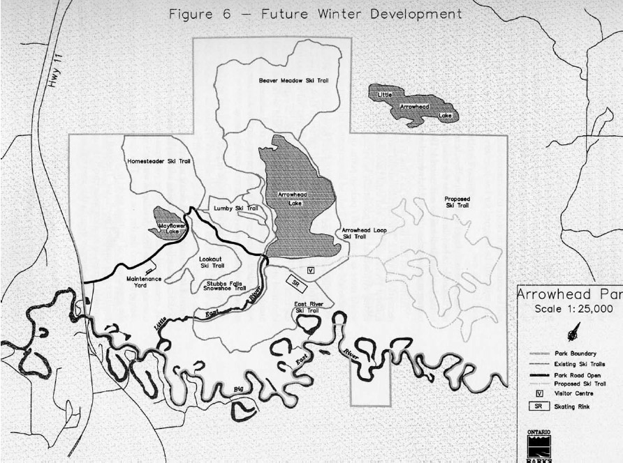
Figure 6 - Future Winter Development

Enlarge Figure 6 – Future Winter Development
9.2 Recreation Facilities
Primary recreation facilities in the Park include beaches and day use areas situated around and adjacent to Arrowhead Lake. No changes are proposed for these facilities.
9.2.1 Trails
In response to the growth in recreational use of bicycles, and the demand by Arrowhead’s campers and day users for cycling opportunities, the modification of two existing cross-country ski trails, Lookout and Arrowhead Lake, will be considered in order to accommodate bicycle use in the non-ski season. The trails will be designed for low-intensity bicycle use, not high impact off-road bicycle use.
To provide linkages with future bicycle trail networks in the Municipality of Huntsville, a bicycle trail from the new park entrance at Muskoka Road #3 to the Lookout Trail will be constructed. This trail will allow residents, cottagers and tourists to travel between the park and the town of Huntsville.
Arrowhead Park may serve as a link in a proposed inter-provincial park recreation corridor. The corridor would join Algonquin Provincial Park to Killbear Provincial Park, and would accommodate such uses as bicycling and hiking. Arrowhead may potentially be incorporated into this network, and would serve as a drop-off pick-up point or as a destination from other access points.
Bicycle trails situated in Arrowhead will be constructed with appropriate materials to accommodate use by a wide variety of bicycle types, user skills and ability levels. A compacted surface would also aid in reducing erosion of the trail. The new entrance trail, and alterations to existing trails, have been identified and flagged in the field. Additional fieldwork has identified a number of recommended alterations to the cross-country ski trails in order to accommodate winter grooming equipment, and to alleviate environmental concerns related to the existing trail configuration.
Due to the tremendous increase in park visitation by cross-country skiers, trails will be added to the existing network (Figure 6). As well, additional trails or modifications to existing trails will be developed to meet the growing demand for freestyle (skate) skiing opportunities. Trail construction and modification will occur following a feasibility study to examine environmental, operational and maintenance concerns. A cross country skiing skills training area has been developed within a forested section adjacent to Roe campground and the day use area. This cleared area provides beginners with the opportunity of learning to ski in a controlled environment under the guidance of a qualified instructor. The trail is situated in an area of easy yet variable terrain as to allow individuals the opportunity to enhance their skills. During the summer months this area will serve as an additional pet exercise area.
The Mayflower Lake, Homesteader’s, and Beaver Meadow hiking trails are all in need of upgrading. The boardwalks on many of the trails need attention or have deteriorated beyond repair. Sections of all trails cross seasonally and permanently wet locations. There is a need to reroute or rebuild boardwalks along these sections to overcome degraded conditions, and to eliminate trails created by hikers by-passing wet areas. The trails must also be clearly marked or signed, and any vegetation imposing on the trail be controlled or removed. In all cases, trails will be rehabilitated in such a way as to minimize annual maintenance.
A viewing platform has been built on the crest of Big Bend Lookout. One is proposed for Beaver Meadow Trail at the actual meadow site. Interpretive signs will accompany both platforms. These platforms will increase the interpretive value of the sites while reducing human impact on these sensitive areas.
9.3 Natural Heritage Education Facilities
To meet the demand for programs, and to provide a focal point for organized park activities, the Arrowhead Lake day use area will be redeveloped. An all-season Park Visitor Complex will be built. The Complex will be designed and constructed to correspond to the park themes, and include a main room for indoor displays and presentations, an information counter and a presentation theatre. The Complex will also include indoor washrooms and a new park store, which would retail gifts, souvenirs, and food items. The location of this facility is central to the three campgrounds, and visitors may walk, bicycle or drive to programs.
In the summer months, the Complex will be the focal point for Natural Heritage Education programs including interpretation, evening programs and outdoor skills training. A new presentation theatre will be constructed within or adjacent to the Complex. Once the new presentation theatre is developed, the existing amphitheatre will be retired and the site rehabilitated. An area near to the Complex will be developed for organized campfires.
In the winter months, the Park Visitor Complex will be the focal point for winter interpretive and skill training programs. The Complex will have facilities for the rental of winter sports equipment, the delivery of winterr ecreation training and a warm-up area for visitors. The Centre will be the starting point for the cross-country ski trail network. The skating rink will be relocated nearby from its present location beside Mayflower Lake.
Modifications to the existing parking lot located at the south end of Arrowhead Lake may be required to provide adequate parking spaces.
9.4 Access and Circulation
The Ministry of Transportation is implementing the conversion of Highway 11 into a limited access four-lane highway from south of the Park northward. This project will necessitate changes to the entrance of Arrowhead Park. The existing entrance will be closed. A new entrance road will be routed from Muskoka Road #3, crossing the Big East River and linked to the present main entrance road. This development will require the construction of a new formal entrance.
The former campgrounds permit office at Mayflower Lake has been expanded and upgraded. This building is now the Main Park Office and Permit Issuing site. No changes are being contemplated to this office or to the Park’s maintenance area. The original Park office is now the Central Region Zone Office of Ontario Parks.
9.5 Service System
Arrowhead Provincial Park hosts over 100,000 day visitors and campers each year. To meet this usage, facilities constructed in the late 1960's, such as the three comfort stations, have been upgraded. The vault privies are subject to continual refurbishment or replacement. All of the vault privies will be upgraded to meet current standards. This will occur as the existing privies reach the replacement stage.
Modifications may be made to the Garbage/Recycling Centres for Roe and East River campgrounds to consolidate facilities.
10.0 Implementation Strategy
The projects and activities described in this plan and listed below will be implemented depending on the availability and allocation of funding each year, and according to the priorities established by Arrowhead Park and Ontario Parks.
10.1 Resource Stewardship
- Conduct Earth Science Inventory of Arrowhead Provincial Park
- Fisheries Management Strategy Vegetation Management Strategy
- Develop Natural Heritage Education self-guided displays
- Construct interpretive panels for Big Bend Lookout platform
- Develop viewing platform and interpretive panels for Beaver Meadow Trail
- Acquire Little Arrowhead Lake property
10.2 Upgrade Facilities
- Upgrade or replace vault privies throughout the park
- Convert Arrowhead Lake and Lookout trails to ski/bike trails
- Upgrade and mark/sign Mayflower Lake, Homesteader’s, and Beaver Meadow hiking trails
- Consolidate Garbage/Recycling Centres for Roe and East River campgrounds
10.3 New Facilities
- Develop bike trail linking Lookout trail to park entrance
- Develop Park Visitor Complex
- Develop new Presentation Theatre
- Develop roofed camping accommodations
- Develop new ski trails for traditional and freestyle skiing
10.4 Other
- Develop Marketing Strategy
11.0 Summary of Public Consultation
The formal release of the Preliminary Plan coincided with a public open house in July 1998. An Invitation to Review and Comment was distributed prior to the open house to entice further participation in the planning process and to solicit input. The invitation was extended to anyone interested, and included park visitors, local residents, local politicians and provincial and national interest groups. Invitations took the form of postings within the Park itself, articles in the local press, direct mailings, and a notice posted to the Environmental Bill of Rights Environmental Registry.
In addition to the mandatory public consultation, as outlined in the Ontario Provincial Park Management Planning Manual (1994), two public meetings were held with concerned local residents and landowners in an attempt to resolve contentious issues regarding the proposal put forward for a potential addition to the park. As a result, the proposal to add 30 hectares of adjacent riverbed to park boundaries has been removed from the plan. The issue of protecting the Big East River will be dealt with separately once the river becomes regulated as a Waterway class Provincial Park through the Ontario Living Legacy Land Use Strategy.
12.0 References
Bergsma, B.M 1996. Arrowhead Provincial Park: Delineation of Nature Reserve Zones. BMB Scientific, Utterson, Ont.
Brownell, V.R 1977. A Reconnaissance Life Science Inventory of Arrowhead Provincial Park. OMNR, Algonquin Region, Huntsville, Ont.
Bruton, D. 1993. Life Science Areas of Natural and Scientific Interest in Site District 5E-8.OMNR, Huntsville, Ont.
Ontario Ministry of Natural Resources. 1997 A research and Information Strategy: Setting Priorities. Occasional Paper Number 2., Ontario Parks Planning and Research Section
Ontario Ministry of Natural Resources. Arrowhead Provincial Park Business Plan 1996-1999 OMNR, Ontario Parks, Huntsville, Ont.
Ontario Ministry of Natural Resources. 1993 Arrowhead Provincial Park Day Visitor and Camper Survey. OMNR, Toronto, Ont.
Ontario Ministry of Natural Resources. 1986. Arrowhead Provincial Park Management Plan. OMNR, Huntsville, Ont.
Ontario Ministry of Natural Resources. 1996. Arrowhead Provincial Park Management Plan Review 1996: Compilation of Background Information. OMNR, Ontario Parks, Huntsville, Ont.
Ontario Ministry of Natural Resources. 1998. Arrowhead Provincial Park Preliminary Management Plan. OMNR, Huntsville, Ont.
Ontario Ministry of Natural Resources. 1988. Bracebridge District Fisheries Management Plan 1986-2000 OMNR, Huntsville, Ont.
Ontario Ministry of Natural Resources. 1994. Ontario Provincial Park Management Planning Manual. OMNR. Provincial Operations Branch, Provincial Parks Operations Section, Peterborough, Ont.
Ontario Ministry of Natural Resources. 1992. Ontario Provincial Parks Planning and Management Policies, 1992 Update. OMNR, Natural Heritage Policy Branch, Toronto, Ont.
Ontario Ministry of Natural Resources. 1988. Ontario Provincial Parks Policy. OMNR, Toronto, Ont.
Ontario Ministry of Natural Resources. 1986-1995. Ontario Provincial Park OMNR, Toronto, Ont.
Ontario Ministry of Natural Resources. 1985. Provincial Park Winter Survey Statistical Summary. OMNR, Huntsville, Ont.
Patton, B 1972. Report on the Geology of Arrowhead Park. OMNR, Huntsville, Ont.
Reid, R. and Bersma, B. 1993. Muskoka Heritage Areas Program, Draft, Integration Report. District of Muskoka and Muskoka Heritage Foundation, Bracebridge, Ont.
Simpson, H. 1977.1980. Arrowhead provincial Park, Ontario Nature Reserve Program-Life Science Inventory Check-Sheets. OMNR, Huntsville, Ont.
Spek, C.M. 1978-1980. Arrowhead Provincial Park, Earth Science Inventory Checklists. OMNR, Huntsville, Ont.