Aubinabong River Provincial Park Management Statement
This document provides direction on the management of Aubinabong River Provincial Park.
Approval Statement
I am pleased to approve this Interim Management Statement for Aubinadong River Provincial Park. Ontario’s Living Legacy Land Use Strategy (1999) has identified this area as a waterway class provincial park. This provincial park was regulated under the Provincial Parks Act in November 2002 (O. Reg. 311/02).
This Interim Management Statement provides direction for the protection and management of Aubinadong River Provincial Park.
Signed by:
Paul Bewick
Zone Manager
Northeast Zone
Ontario Parks
Date: January 3, 2007
1.0 Introduction
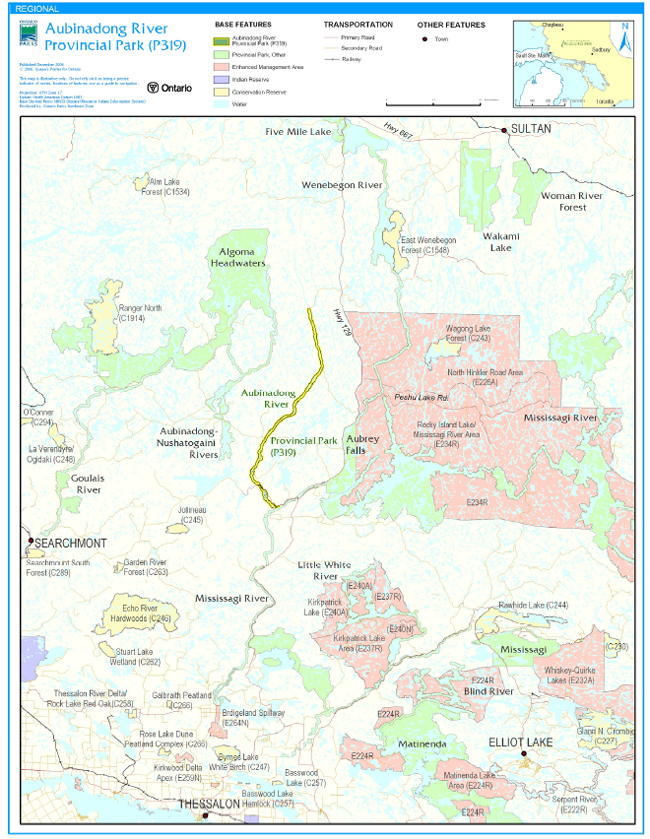
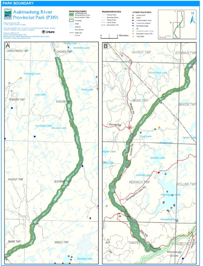
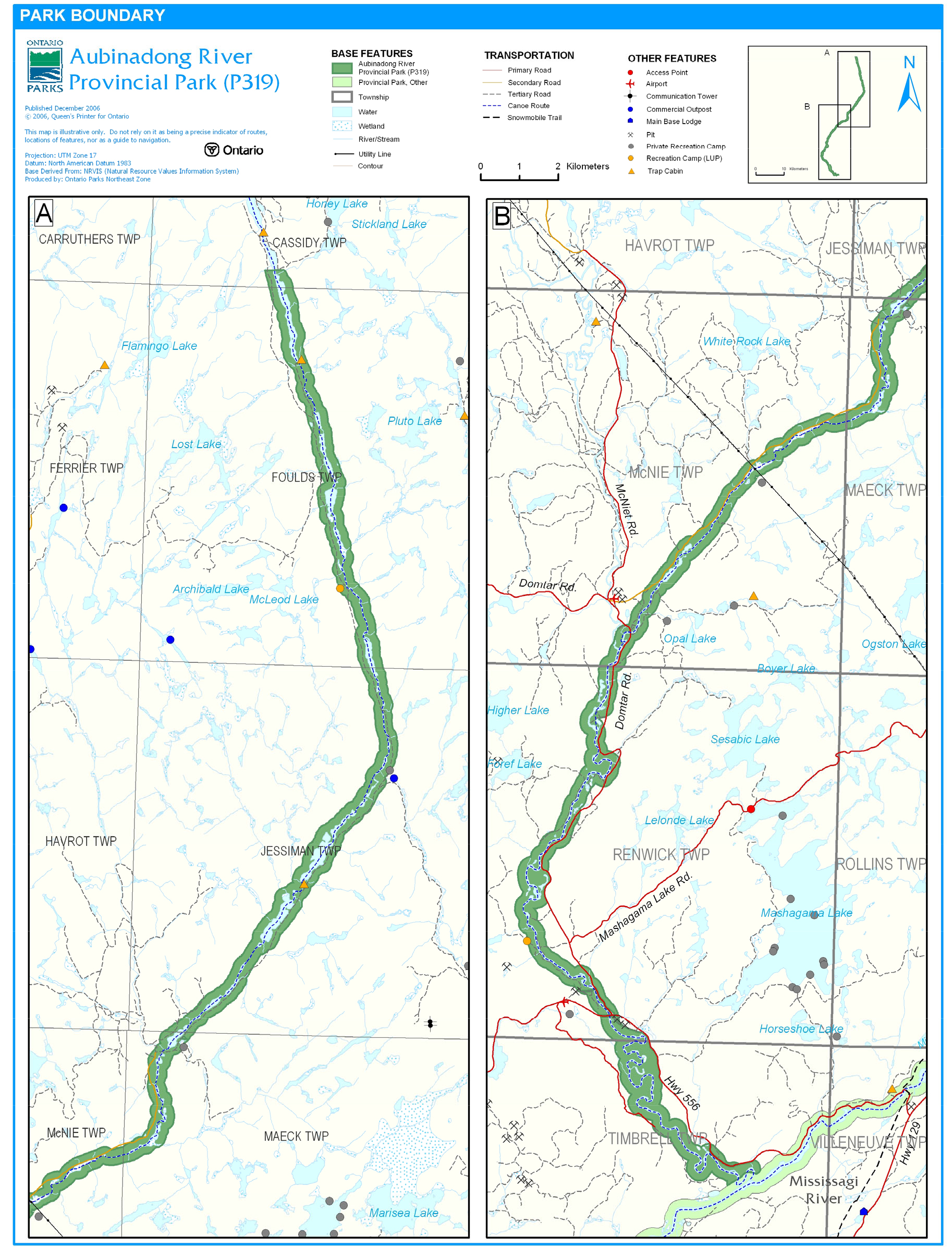
Aubinadong River Provincial Park is located to the north of Thessalon and east of Searchmont (Figure 1). Approximately 50 kilometres of the Aubinadong River is protected by the park. The park is located in the townships of Cassidy, Foulds, Jessiman, Maeck, McNie, Renwick, and Timbrell (Figure 2). This 2,722 hectare park follows the Aubinadong River and includes a 200- metre setback from the water’s edge.
Aubinadong River Provincial Park was regulated in November of 2002 (O. Reg. 311/02). The park was designated through Ontario’s Living Legacy Land Use Strategy (OMNR 1999) and was classified as a waterway park. The purpose of the waterway designation is to protect outstanding recreational water routes and to provide high quality recreational and educational opportunities.
1.1 Objectives
Aubinadong River Provincial Park will be managed consistent with the four objectives for provincial parks:
Protection: To protect provincially significant elements of the natural and cultural landscapes of Ontario.
Recreation: To provide provincial park outdoor recreation opportunities ranging from high-intensity day-use to low-intensity wilderness experiences.
Heritage Appreciation: To provide opportunities for exploration and appreciation of the outdoor natural and cultural heritage of Ontario.
Tourism: To provide Ontario’s residents and out-of-province visitors with opportunities to discover and experience the distinctive regions of the Province.
2.0 Management Context
The purpose of this Interim Management Statement (IMS) is to provide direction to ensure the custodial management of park resources. Future park planning may be undertaken as required to provide direction on significant decisions regarding resource stewardship, development, operations and permitted uses.
Park management will follow direction from:
- Provincial Parks Act (1990) and regulations
- Ontario Provincial Parks Planning and Management Policies (OMNR 1992)
- Ontario’s Living Legacy Land Use Strategy and policy clarifications (OMNR 2000), amendments, and related direction
- Crown Land Use Policy Atlas (OMNR 2004a).
In addressing custodial management obligations to protect park values and ensure public health and safety, Ontario Parks will ensure that policy and Environmental Assessment Act (1990) requirements are implemented.
2.1 Environmental Assessment
As a part of the Ontario Ministry of Natural Resources (MNR), Ontario Parks is a public sector agency which is subject to the Environmental Assessment Act. Park management will be carried out in accordance with legislation, policies, and guidelines that are required under A Class Environmental Assessment for Provincial Parks and Conservation Reserves (OMNR 2005)
Figure 1: Regional Setting
Figure 2: Park Boundary
3.0 Park Features and Values
Over 100 kilometres long, the Aubinadong River originates in the northwest corner of Whitehead Township and flows down into the Mississagi River. Approximately half of the entire river is protected by this provincial park.
The park consists of a series of wide slow-moving stretches that are connected by narrow channels of fast water. The river flows through a varied landscape of high, rugged rock cliffs, in the north and gentle lower lying areas, to the south. The wild river valley nature of the park and its associated riparian habitats make this area regionally significant. The park provides habitat for a wide variety of bird and herpitile species and may even provide habitat for peregrine falcons, a threatened species (Morris 2002).
The park is completely contained within part of a traditional Aboriginal canoe route, the Aubinadong River East Branch Canoe Route (Canadian Canoe Routes 2006), which is linked to the Mississagi River Canoe Route.
3.1 Geological Features
The Precambrian bedrock of Aubinadong River Provincial Park is made up of granitic and gneissic rock of Archean age of the Abitibi Subprovince. Proterozoic age diabases dikes that cut into the granite and granitic talus slopes at the foot of cliffs are also present. The course of the river is strongly controlled by the regional fracture pattern throughout the length of the park, described as a "dog’s leg" pattern (Blackburn 2004).
The quaternary deposits in the park consist of an alluvial plane of glaciofluvial outwash, through which the river meanders at the southern end of the park. Oxbow lakes and scars are common in this area of the park. At the north end, the river travels through high rock-bound canyons that may contain talus boulders of Algoman Granite with little alluvium in the river valley (Blackburn 2004).
Granitic rocks of a major batholithic area, Proterozoic diabase dikes and riverine landform features in the lower reaches of the river, such as meanders, terraces and incising, are all of local significance (Blackburn 2004).
3.2 Biological Features
The Aubinadong River Provincial Park is located in Ecodistrict 4E-3 and contains esker fragments, kettle-lake features, as well as stranded oxbow ponds. The park contains major representations of mixed pine uplands, jack pine, intolerant hardwoods, and nutrient-rich coniferous forests. Several small patches of old growth white pine are located adjacent to the river (Morris 2002).
The sand banks of the river are utilized by various nesting birds, including swallows and kingfishers, as well as by nesting turtles. The high cliffs in area may also provide nesting opportunities for ravens and hawks (Morris 2002). The oxbow and kettle ponds provide habitat for a variety of herpetile and bird species. The river supports populations of brook trout, walleye and pike (OMNR 2001).
The site is ecologically linked to the Mississagi River Provincial Park Additions and its associated network waterway parks, and forms the headwaters of the lower Mississagi River. The area is considered to be regionally significant because of the wild river valley nature of the site and the associated riparian habitats (Morris 2002).
3.3 Cultural Setting
An investigation into the cultural features specific to Aubinadong River Provincial Park has not been completed at this time; however, the Aubinadong River is a known traditional travel route for First Nations while hunting and trapping.
Any future planning will be within the context of a provincial framework, A Topical Organization of Ontario History (OMNR 1974). In addition, updates and discussions with First Nations and other agencies and stakeholders may be carried out to identify cultural heritage values and features within the park and their significance. This information may be used to develop management guidelines to conserve and protect representative archaeological and historical values and features, or to provide direction for further research.
3.4 Recreation
The recreational opportunities of this park are largely water-oriented. The main recreational activities include canoeing, fishing, and hunting. Nature appreciation activities (e.g., wildlife and landscape viewing) and camping are occurring in conjunction with the canoeing activity on the river.
A portion of the Aubinadong River East Branch Canoe Route is located with the park (Canadian Canoe Routes 2006). This route, which links to the Mississagi River Canoe Route, is recommended for experienced canoeists only (Harper 2002).
4.0 Aboriginal Uses
Aubinadong River Provincial Park lies within the Robinson Huron Treaty of 1850 and is not particularly close to any given Indian Reserves.
Discussions regarding the regulation of the boundary of this park were conducted with Batchewana, Garden River, Mississauga, Serpent River, and Thessalon First Nations. No issues regarding the regulation of this park were identified (OMNR 2002).
First Nations have expressed interest in and have shared knowledge of the park and surrounding area. Aboriginal communities have used the area for hunting, trapping, fishing, gathering and travel. These uses may continue, subject to public safety, conservation and other considerations.
Any communications and cooperation between Aboriginal communities and the MNR for planning and operations purposes will be done without prejudice to any future discussions or negotiations between the government of Ontario and Aboriginal communities.
5.0 Stewardship Policies
The removal, damage or defacing of Crown properties, natural objects, relics, and artifacts is not permitted (Provincial Parks Act).
Non-native species will not be deliberately introduced into the park. Where non-native species are already established and threaten park values (i.e., has become invasive), a strategy to control the species may be developed (OMNR 1992).
5.1 Terrestrial Ecosystems
5.1.1 Vegetation
Harvesting
Commercial forest operations are not permitted within the park (OMNR 1992).
The harvest of non-timber forest products such as club moss, Canada yew, etc., will not be permitted (OMNR 1992).
Existing authorized wild rice harvesting may continue. New operations will not be permitted.
There are no fuelwood cutting permits currently issued for the park. New permits will not be issued (OMNR 2000).
Insects and Disease
Insects and diseases may be managed where the aesthetic, cultural, or natural values of the park are threatened (OMNR 1992). Control measures will follow guidelines established by the Ontario Ministry of the Environment (MOE) and MNR. Whenever possible, biological control measures will be given preference over the use of chemicals (OMNR 1992).
Fire
Aubinadong River Provincial Park is located within the Great Lakes - St. Lawrence Fire Management Zone. In accordance with existing provincial park policy and the Forest Fire Management Strategy for Ontario (OMNR 2004b), forest fire protection will be carried out in the park as on surrounding lands. Whenever feasible, MNR’s Forest Fire Management program will use techniques that minimize damage to the landscape, such as limiting the use of heavy equipment or limiting the number of trees felled during response efforts (OMNR 2004b).
Wildlife Management
Aubinadong River Provincial Park is located within Wildlife Management Units 35 and 36. The removal or harassment of non-game animals is not permitted (Provincial Parks Act).
Hunting
Sport hunting is permitted to continue. Considerations of safety and conservation with respect to hunting may be made through future management planning, which would include public and Aboriginal consultation (OMNR 2000).
The Fish and Wildlife Conservation Act (1997) and the Migratory Birds Convention Act (1994) govern hunting within the park. The Ontario Hunting Regulations Summary contains regulations specific to this area. The harvest of bullfrogs or snapping turtles is illegal in provincial parks.
Bear Management Areas
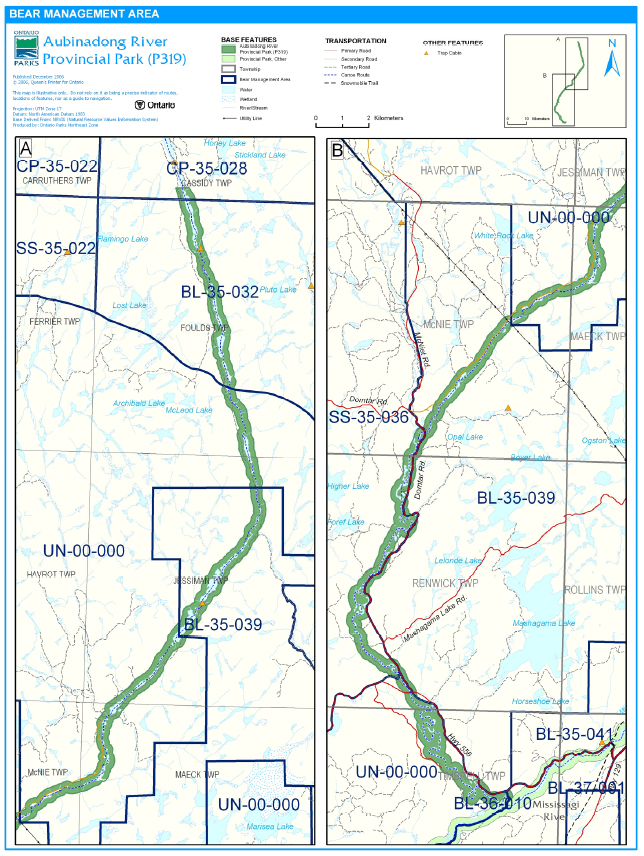
Aubinadong River Provincial Park includes portions of five bear management areas: BL 35-032, BL 35-039, CP 35-028, SS 35-036, and BL-36-010 (Figure 3). Portions of two vacant bear management areas (UN-00-000) are currently vacant and included within park boundaries. These areas may be reallocated in the future.
Existing commercial bear hunting operations are permitted to continue. This activity may be subject to conditions identified during future planning (e.g., the designation of nature reserve zones). New BMA licences will not be permitted (OMNR 2000; 2003a).
Figure 3: Bear Management Area
Trapping
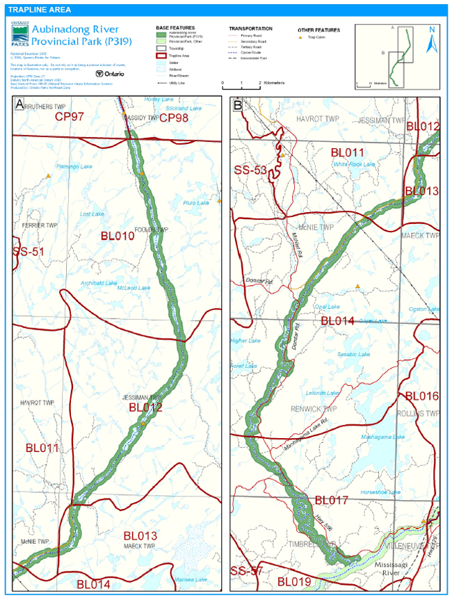
There are portions of eight licensed traplines included within the park: BL-010, BL-011, BL-012, BL-013, BL-014, BL017, CP-098, and CP-097 (Figure 4). Two trap cabins, associated with traplines BL10 and BL12, are within the park.
Existing commercial fur harvesting operations may continue where the activity has been licensed or permitted since January 1, 1992. New operations, including trap cabins and trails, will not be permitted (OMNR 2000; 2003a). Transfers of active trap line licenses are permitted, subject to a review of potential impacts and the normal transfer or renewal conditions that apply1.
5.1.2 Industrial Resources
Aggregate: There are known aggregate pits (active or inactive) located within the boundary of Aubinadong River Provincial Park. Aggregate extractions authorized by the Aggregate Resources Act on the date of approval of this IMS are allowed to continue. As the site limits are worked, there will be progressive or sequential restoration of the pits to allow the site to return to a natural condition (e.g., slope stabilization, native species plantings, etc.).
There may be parties interested in processing an application(s) for an aggregate permit/licence in Aubinadong River Provincial Park. The Aggregate Resources Act does not exempt or supersede other legislative or regulatory requirements such as the Environmental Assessment Act or the Provincial Parks Act and associated regulations. There is a legal obligation that these requirements must be met before an application for an aggregate permit/licence can proceed or be processed in a provincial park.
Specific to Crown land set aside and regulated under the Provincial Parks Act and the Crown’s legal obligations under the Environmental Assessment Act, the need for additional aggregates to be sourced in Aubinadong River Provincial Park must be addressed as a policy statement in a management plan developed through public consultation and a regulation under the Provincial Parks Act. Aubinadong River Provincial Park does not have a management plan developed through public consultation nor is there a regulation under the Provincial Parks Act. As such an application for an additional aggregate authorization(s) under the Aggregate Resources Act can not proceed or be processed for sites within Aubinadong River Provincial Park.
The Class Environmental Assessment for Provincial Parks and Conservation Reserves does provide for the implementation of projects not considered in a management plan developed through public consultation in situations where there are important benefits. In such limited cases, a minimum of a Category C evaluation and consultation process will be undertaken as described in Section 5 of the Class EA, with full consideration of alternatives.
The Provincial Parks and Conservation Reserves Act received Royal Assent on June 20, 2006 and is pending proclamation. Once the Act is proclaimed aggregate extraction in Aubinadong River Provincial Park will not be permitted except for aggregate pits that are authorized under the Aggregate Resources Act on the day the Act is proclaimed. No additional authorizations will be permitted in the park after the proclamation of the Provincial Parks and Conservation Reserves Act.
Figure 4: Trapline Area
Mineral Exploration and Mining: There are no existing mining claims within the park. Mineral exploration and mining are not permitted within the park. The mining and surface rights on all lands within the park have been withdrawn from staking under the Mining Act (1990). In accordance with Ontario’s Living Legacy Land Use Strategy, however, access in the park to mining lands (i.e., forest reserve(s) and mining patents) will be permitted for purposes of mineral exploration, development, or operations. Access will be planned in accordance with Environmental Assessment Act requirements.
5.1.3 Access and Crossings
Access
The park is accessible by road and water at various locations.
Highway 556, Domtar Road, and Aubinadong Road allow for access to most of the southern half of the park. The northern half of the park is not accessible by primary or secondary roads.
A series of tertiary/forest access roads may provide access to the site by ATV or snowmobile.
The Aubinadong River provides access to the park via canoe route.
Roads
There are several roads located adjacent to and within Aubinadong River Provincial Park.
Highway 556 crosses through the park in Timbrell and Renwick Township. The highway corridor is not included within the boundary of the park.
The Domtar Road is a long term haul road used by Northshore Forest Incorporated. This road is located in Renwick, McNie, Jessiman, and Maeck Townships. This road roughly parallels the Aubinadong River through Renwick and McNie Townships. The Domtar Road crosses over the river in McNie Township. Portions of this road are included in the park boundary.
The Aubinadong Road branches from the Domtar Road in McNie Township. This road, which follows the Aubinadong River, is located in McNie, Maeck, and Jessiman townships. This road is not currently used by the forest company, but was identified as a long term haul road and can be used for forestry purposes in the future. The majority of this road is included within the park boundary.
Two crossings of the Aubinadong River in Maeck and Jessiman townships are permitted; these crossings will be re-installations of the existing, prior crossings of this river at these locations.
Where existing forest access roads are essential for continued access beyond the park for forest management, access to in-holdings (i.e. land use permits, patents etc.) or recreation purposes, and alternative road access does not exist, or road relocation is not feasible, existing roads will continue to be available for access. Continued use will include maintenance and may include upgrades (OMNR 2004a). Ontario Parks is not responsible for the maintenance or upgrade of any roads within the park boundary.
Any proposed development, maintenance or upgrading of existing roads must meet all Environmental Assessment Act requirements.
Utility Corridors
A hydro corridor runs through the park in McNie Township. This corridor is managed by the MNR through a province-wide land use permit (LUP) issued to Hydro One.
The maintenance of the existing utility lines will be permitted. Maintenance activities must adhere to the regulations set out under relevant acts, such as the Environmental Assessment Act, the Canadian Environmental Protection Act (1999), and the Pesticides Act (1990) and shall not negatively impact the values being protected within this park.
All public utilities (e.g., gas pipelines, transmission lines, communications towers) must avoid park lands wherever possible. New utility corridor crossings may be necessary to maintain essential public services (OMNR 2004a).
Any future utility corridors proposed through the park, where park lands are unavoidable, will be reviewed on a case-by-case basis. Protection of park features and values will be priority and all requirements of the Environmental Assessment Act will be met.
Recreational Trails
Canoe Routes: The Aubinadong River is part of two documented canoe routes. The Aubinadong River-East Branch Canoe Route and the Aubinadong River - Five Mile Lake to Mississagi River route both travel along the Aubinadong River. The Aubinadong River-East Branch Canoe Route is almost entirely encompassed by the park.
Hiking Trails: There are no designated hiking trails within in Aubinadong River Provincial Park. New trails (e.g., hiking) may be developed if the need arises. Any proposed development within the park is subject to Environmental Assessment Act requirements.
ATV Trails: There are no authorized ATV trails within the park boundary; however, there is existing unauthorized ATV use on forestry and tertiary roads within the park. Existing use of these roads to access private in-holdings and LUPs is permitted continue unless this use threatens park values. ATV use may be authorized on old forest access and tertiary roads; this use will be reviewed during future park management planning. Off-trail and off-road ATV use is not permitted (OMNR 2000).
Snowmobile trails: There are no authorized snowmobile trails within Aubinadong River Provincial Park; however, there may be some snowmobile use along existing forestry and tertiary roads. Snowmobile use on existing routes for access to private in-holding, LUPs and recreational ice fishing may continue unless park values are threatened. Snowmobile use may be authorized on old forest access and tertiary roads. Off-trail snowmobile use is not permitted. New snowmobile trails may be considered though future park management planning (OMNR 2000).
5.1.4 Adjacent Land Management
Forestry
The land adjacent to the park is located within the Martel Forest Management Unit (#509) and the Northshore Forest Management Unit (#680) (OMNR 2006).
The Superior-Martel Forest is currently managed by Tembec Industries Limited. The management plan for this forest is to be renewed in 2011.
The Northshore Forest is currently managed by Northshore Forest Incorporated. The management plan for this forest is to be renewed in 2010 (OMNR 2006).
Provincial Parks
Mississagi River Additions Provincial Park (P238) borders the southern boundary of Aubinadong River Provincial Park. This 91,247 hectare park has natural heritage and recreational values including significant stands of white pine along the northshore of Wakomata Lake, waterfalls as well as a waterway connection via canoe route to various parks and conservation reserves in the area.
General Use Areas
Aubinadong River Provincial Park is located adjacent to two general use areas.
Multiple Use Area General Use Area (G1890): This 406,824 hectare area, which surrounds the majority of the park, is managed primarily for forestry, Crown land recreation, and commercial/private recreation.
General Mixed Use Areas General Use Area (G1770): This 1,495,186 hectare area surrounds the northern tip of the park. It is primarily managed for the expansion of the forest, mining, and trapping sectors. These uses will be intermixed with locally-dominant recreation and tourism.
5.1.5 Land Disposition
Aubinadong River Provincial Park is located within the townships of Cassidy, Foulds, Jessiman, Maeck, McNie, Renwick, and Timbrell. This park is within MNR’s Sault Ste. Marie and Chapleau districts.
New land disposition for the private use of individuals or corporations will not be permitted (OMNR 1992; 2000).
Land Use Permits, Licenses of Occupation, and Unauthorized Occupations
One private recreation camp LUP occurs within the park. There is also a province wide LUP, to Hydro One, for the portion of the utility line which crosses through the park in McNie Township.
Existing authorized LUPs may be eligible for enhanced tenure but not the purchase of land. Recreational camp LUPs cannot be changed to commercial LUPs unless this is supported during a review as part of park management planning. Enhanced tenure is defined as a possible extension of the term of the LUP for up to 10 years or upgrade in tenure (i.e. LUP to lease) (OMNR 2000a).
Enhanced tenure for an LUP is not guaranteed. Requests for enhanced tenure or to transfer LUPs will be reviewed based upon the following criteria:
- Continued compliance with the conditions of the LUPs
- Current land disposition policies for LUPs
- Consistency with park objectives to sustain values – no effects on heritage values and/or conflict with other uses
- Consistency with Aboriginal land claim negotiations or protocol agreements
- All rents, taxes, fees, rates, or charges are paid and in good standing.
An extension in the term of tenure for an existing LUP does not convey a commitment to provide for a change in the type or the standard of existing access to the private recreation camp.
There are no known licences of occupation and one unauthorized occupation within the park.
Patent Land
Aubinadong River Provincial Park encloses one parcel of patent land in Maeck Township and abuts two other parcels of patent land in McNie and Jessiman townships. Private land is not included within the park boundary and, as such, park policy does not apply.
Boat Caches
There are no authorized boat caches located within the park. Boats are not permitted to be left unattended in the park without written permission from the superintendent under the authority of the Provincial Parks Act.
5.2 Aquatic Ecosystems
Sustaining quality water resources is integral to the protection of park and adjacent land values. The MOE enforces applicable legislation and regulations for water quality.
5.2.1 Water Management
There are currently no hydro development, water control structures, or diversions within Aubinadong River Provincial Park.
New commercial hydroelectric developments will not be permitted (OMNR 2000).
Fisheries Management
The Aubinadong River supports brook trout, walleye, and northern pike populations (OMNR 2001). Fisheries management will complement the maintenance and enhancement of native, self-sustaining fish populations (OMNR 1992).
Sport Fishing
Sport fishing is permitted within the park. This activity is governed by legislation and regulations in the Fish and Wildlife Conservation Act and the Fisheries Act (1985). The Recreational Fishing Regulations Summary contains details on the applicable regulations for this area.
Commercial Baitfish Harvesting
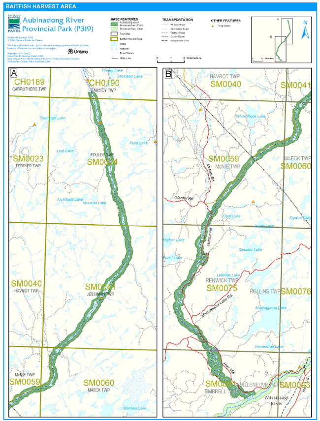
Aubinadong River Provincial Park includes portions of seven allocated baitfish harvesting license areas: SM0091, SM0075, SM0059, SM0041, SM0024, SM0060, and CH0190 (Figure 5).
Existing commercial baitfish harvesting may continue where the activity has been licensed or permitted since January 1, 1992. This activity may be subject to conditions identified through future park management planning or fisheries management plans. New baitfish licenses will not be permitted (OMNR 2000; 2003a).
Fish Stocking
The stocking of native fish species may be considered through park management planning, with full public and Aboriginal consultation. Non-native fish species will not be deliberately introduced into park waters (OMNR 1992).
6.0 Operations Policies
6.1 Recreation Management
Future planning, with full public consultation, will review direction on motorized and non-motorized recreation uses.
6.1.1 Motorized Recreation
Motorboats
Motorboat use is permitted to continue, unless park values are being threatened (OMNR 2004a).
Aircraft
Aircraft landings are permitted within this waterway park (OMNR 2004a). All aircraft landings are subject to regulation and valid aircraft landing permits issued by the park superintendent under the authority of the Provincial Parks Act.
Figure 5: Baitfish Harvest Area
Snowmobiles
There are currently no authorized snowmobile trails within the park. Snowmobile use on established routes for access to private land in-holdings, LUP areas, and recreational ice fishing may continue unless park values are threatened. Snowmobile use may be authorized on old forest access and tertiary roads. Off-trail snowmobile use is not permitted within the park. New snowmobile trails may be considered during future planning (OMNR 2000).
All-Terrain Vehicles
There are no authorized ATV trails within the park boundary. Existing use of forest and tertiary access roads to access private in-holdings and LUPs is permitted continue unless this use threatens park values. ATV use may be permitted on old forest access and tertiary roads. The off-road or off-trail use of ATVs will not be permitted. Proposals for new trails may only be considered during future planning with public and Aboriginal consultation (OMNR 2000).
6.1.2 Non-Motorized Recreation
Camping
There are currently no managed campsites within Aubinadong River Provincial Park; however, several unmanaged campsites are used along the canoe route.
Ontario Parks may assess the condition of existing campsites and will maintain, rehabilitate, or close sites as required. If there is an identified need, new campsites may be considered (OMNR 2004a). Infrastructure will be permitted in order to protect park features and values in response to use, environmental deterioration and environmental protection requirements. Any proposed development in the park must fulfill the requirements of the Environmental Assessment Act.
Hiking
There are no authorized hiking trails within the boundaries of this provincial park. If there is an identified need, the development of new hiking trails may be considered. Trail infrastructure to protect park values and features will be permitted. Any proposed development within the park is subject to Environmental Assessment Act requirements.
Canoeing/Kayaking
Existing uses may continue, unless park values are threatened (OMNR 2004a). Infrastructure to protect park features and values may be permitted and developed in response to use, environmental deterioration and environmental protection requirements.
6.1.3 Emerging Recreational Uses
There are emerging recreational uses for which there is limited or no policy to deal with their management (e.g., adventure racing, geocaching). The park superintendent will use legislation, policy, and guidelines which are in place to manage emerging uses in the interim.
6.2 Development
There is no existing park infrastructure located within the boundary this park. Infrastructure to protect park features and values may be permitted and developed in response to use, environmental deterioration, and environmental protection requirements. Any proposed development within the park is subject to the Environmental Assessment Act.
6.3 Commercial Tourism
New commercial tourism facilities may be considered where they would be consistent with park policy (OMNR 2004a). Any development must meet the requirements of the Environmental Assessment Act. Existing authorized tourism facilities may continue subject to management prescriptions determined through management planning. Existing tourism facilities (e.g., LUPs, leases) may be eligible for enhanced tenure, and decisions will be made in management planning.
7.0 Cultural Resources
An assessment of the cultural resources specific to Aubinadong River Provincial Park has not been completed at this time, however upon completion; management of any cultural values within this park will be directed toward protection and heritage appreciation (OMNR 1992).
8.0 Heritage Education
Literature and other supporting information may be developed to describe the park in the context of Ontario’s provincial park system. Boundary limits, significant heritage features and permitted uses of the may be included in park literature.
Prospective park visitors may be informed about the sensitivity and significance of park values through park literature.
9.0 Research
Scientific research by qualified individuals which contributes to the knowledge of natural or cultural history, or to environmental or recreational management, may be encouraged in the park. Ontario Parks will encourage institutions, such as universities, to undertake research projects.
All research programs will require the approval of Ontario Parks and are subject to park policy and other applicable legislation. Any materials removed from the park will remain the property of Ontario Parks.
Approved research activities and facilities will be compatible with the park’s protection objective. Any site which is affected by research will be rehabilitated as closely as possible to its original state. Environmental Assessment Act requirements will apply.
10.0 References
Aggregate Resources Act, 1990
Blackburn, C.E., 2004. Earth Science Inventory Checklist Aubinadong River P319. Blackburn Geological Services for the OMNR.
Canadian Environmental Protection Act, 1999.
Canadian Canoe Routes, 2006. Canadian Canoe Routes Home Page. Accessed December 14, 2006. http://www.myccr.com/canoedb/routeDetails.php?routeid=144
Environmental Assessment Act, 1990.
Fisheries Act, 1985.
Fish and Wildlife Conservation Act, 1997.
Harper, T., 2002. Aubinadong River Provincial Park (P319) Recreation Inventory Report – Version 1.2. OMNR
Mining Act, 1990.
Migratory Birds Convention Act, 1994
Morris, E. R., 2002. Natural Heritage Area Life Science Checksheet – Aubinadong River (OLL P319). OMNR
Ontario Ministry of Natural Resources, 1974. A Topical Organization of Ontario History. Historic Sites Branch Division of Parks.
Ontario Ministry of Natural Resources, 1992. Ontario Provincial Parks Planning and Management Policies, 1992 Update.
Ontario Ministry of Natural Resources, 1999. Ontario’s Living Legacy Land Use Strategy.
Ontario Ministry of Natural Resources, 2000. Ontario’s Living Legacy Land Use Strategy (Policy Clarification).
Ontario Ministry of Natural Resources, 2001. Aubinadong River Provincial Park (P319) Factsheet. Ontario Ministry of Natural Resources, 2002. Public and Aboriginal Consultation Documentation Form Ontario’s Living Legacy Protected Area Boundary Refinement Review – Aubinadong River Provincial Park.
Ontario Ministry of Natural Resources, 2003a. Directions for Commercial Resource Use Activities in Provincial Parks and Conservation Reserves. 5 pp.
Ontario Ministry of Natural Resources, 2003b. Resolving OLL – MTO conflicts: MTO aggregate pits affected by OLL site regulations. 5 pp.
Ontario Ministry of Natural Resources, 2004a. Crown Land Use Policy Atlas.
Ontario Ministry of Natural Resources, 2004b. Forest Fire Management Strategy for Ontario.
Ontario Ministry of Natural Resources, 2005. A Class Environmental Assessment for Provincial Parks and Conservation Reserves.
Ontario Ministry of Natural Resources, 2006. List of Forest Management Units (MU) in Ontario (2006/2007) (designated under the Crown Forest Sustainability Act, Section 7) All Management Units effective as of April 1, 2006. Accessed December 15, 2006. http://ontariosforests.mnr.gov.on.ca/spectrasites/Viewers/showArticle.cfm?id=C74F77D4- 68C7-41A6- 8D96FB6079073782&method=DISPLAYFULLNOBARNOTITLE_R&ObjectID=C74F77D4-68C7- 41A6-8D96FB6079073782&lang=FR&lang=EN&lang=FR&lang=EN (Link no longer active)
Pesticides Act, 1990.
Provincial Parks Act, 1990.
Provincial Parks and Conservation Reserves Act, 2006
11.0 Appendix A: Background Information
| Name | Aubinadong River Provincial Park (P319) |
|---|---|
| Classification | Waterway |
| Ecoregion/Ecodistrict | 4E-3 (Mississagi) |
| OMNR Administrative Region/District | Northeast – Sault Ste. Marie, Chapleau |
| Total Area (ha) | 2,722 |
| Regulation date and Number | November 2002 (O. Reg. 311/02) |
Representation
Earth Science:
Archean age Abitibi Subprovince: Algoma granitic and gneissic rocks. Two suites: massive to foliated granodiorite to granite suite predominates; gneissic tonalite suite, consisting of foliated to gneissic tonalite to granodiorite with minor supracrustal inclusions, at extreme north end only. Proterozoic age diabase dikes cut the granite. The diabase dikes and Algoman Granite cut in at Renwick Township are located at a portage on the river that is also accessible as a popular launching/landing point by road off Highway 129. The site offers an excellent opportunity for a permanent interpretive display or plaque emphasizing these important geologic features (both the diabase dikes and the granite). Granitic talus slopes are also found at foot of cliffs. Pleistocene age: glaciofluvial outwash or valley train material confined to the river valley. River flows in long linear valleys controlled by major fault and fracture sets in Archean granitic basement. Two major sets, at N20W and N40-50W, giving rise to "dog’s leg" pattern to the river course. In lower reaches, near its confluence with the Mississagi River, valley widens, with development of an alluvial plane, and meander pattern, terraces and river-bank bluffs (Blackburn 2004).
The glaciofluvial outwash or valley train sands and gravels that have been exploited in the past, that are sensitive to any further human exploitation, are adequately protected by park status. Natural processes, mostly fluvial, will continue to operate, but not change the landscape in the foreseeable future (Blackburn 2004).
Granitic rocks of a major batholithic area are difficult to access compared to other protected areas and are thus of local significance. A good outcrop of small scale Proterozoic diabase dikes which intrude into Algoma Granite in Renwick Township are also of local significance. Riverine landform features in the lower reaches of the river, such as meanders, terraces and incising are also of local significance (Blackburn 2004).
Life Science:
The Aubinadong River is located in Ecodistrict 4E-3 and contains esker fragments, kettle-lake features as well as stranded oxbow ponds. An analysis of digital forest resource inventory (FRI) data was used to obtain quantitative estimates of Ecosite representations for the provincial park. Four major Ecosite representations (100-1000 ha) occurred within the park; these included mixed pine uplands, jack pine forest, intolerant hardwood forest, and nutrient-rich coniferous forests. Five modest (10-100 ha) and four small (<10 ha) Ecosite representations are also represented in this park. Small patches of old growth white pine (Pinus strobus) may be seen immediately adjacent to the river in several locations. The Mississagi Fire of 1948 travelled through the Aubinadong River area and burned thousands of hectares of forest. Thus, most of the forest cover in this park is second growth however, patches of old growth white pine still exist (Morris 2002).
The Aubinadong is a medium sized river with deep sections that are interrupted by a few swifts, rapids, and falls, providing habitat for both warm and cold-water fish species. The river supports populations of brook trout, walleye and pike. The water is dark coloured as it contains a significant amount of humic acid. The river is occasionally flanked by tall shrub thickets of alder (Alnus incana ssp. rugosa; A. viridis ssp. crispa) or native hollys (Ilex verticillata; Nemopanthus mucronatus), while open wetlands are less common (Morris 2002).
The sand banks of the river are utilized by various nesting birds including swallows and kingfishers as well as by nesting turtles. The high cliffs in area may also provide nesting opportunities for ravens, hawks and potentially the peregrine falcon. The oxbow and kettle ponds provide habitat for a variety of herpetile and bird species (Morris 2002).
The site is ecologically linked to the Mississagi River Provincial Park Additions and its associated network waterway parks, and forms the headwater of the lower Mississagi River. The area is considered to be regionally significant because of the "wild river valley" nature of the site and the associated riparian habitats (Morris 2002).
Cultural Resources:
An investigation and analysis of the cultural resources specific to Aubinadong River Provincial Park has not been completed at this time. However, it is known that the Aubinadong River is a traditional travel route for First Nations.
Recreation and Tourism:
The recreational opportunities of Aubinadong River Provincial Park, a waterway class park, are largely water oriented.
There are two documented canoe routes that follow the Aubinadong River; the Aubinadong River – East Branch Canoe Route and the Aubinadong River – Five Mile Lake to Mississagi River route. The Aubinadong River – East Branch Canoe Route is almost entirely within the park. This route is three days and approximately sixty kilometres in length. The Five Mile Lake to the Mississagi River route was maintained by the Ministry of Natural Resources in the past. The start of this route is accessed through Five Mile Lake Provincial Park. If the entire canoe route is travelled, the trip is five days and approximately ninety-eight kilometres.
Canoeing, hunting, fishing and general nature appreciation activities are occurring within this park. Camping is also occurring in conjunction with the canoeing activity on the river.
Inventories
| Survey Level | Earth Science | Life Science | Cultural | Recreational |
|---|---|---|---|---|
| Reconnaissance | Blackburn, 2004 | Morris, 2002 | Required | Harper, 2002 |
1Transfers include situations where a license is surrendered with a request that it be immediately reissued to another individual or organization that is assuming an existing operation. Trap cabins are considered part of a trapline and would be transferred with the trapline for the purposes of trapping. If a trapline license is revoked or surrendered, all portions of the registered line within the park will be rescinded from the legal description of the trap line (OMNR 2003a).