Bass Lake Provincial Park Management Plan
This document provides direction on the management of Bass Lake Provincial Park.
ISBN-0-7729-2332-9
© 1987 Government of Ontario
Additional copies of this publication are obtainable from:
Ministry of Natural Resources
Huronia District Office
Midhurst, Ontario
LOL 1XO
We are pleased to approve Bass Lake Provincial Park Management Plan, as official policy for the management and development of this park. The plan reflects this ministry’s intent to protect natural and cultural features of Bass Lake and maintain and develop high quality opportunities for outdoor recreation and heritage appreciation for both residents of Ontario and visitors to the Province.
M. Fordyce
Regional Director
Central Region
N. Richards
Director, Parks
Recreational Areas Branch
1.0 Introduction
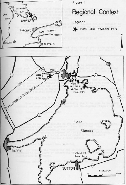
Bass Lake Provincial Park has a 33 ha land area and a 5 ha water area. The park is located on the southeast shore of Bass Lake, four kilometres west of the City of Orillia (Figure 1).
The park is within the Georgian Lakelands Tourist Region, an area characterized by a great deal of cottaging activity on Georgian Bay, Lakes Simcoe and Couchiching, the Trent-Severn River System and numerous small inland lakes. There are several tourist attractions in the area including Ste. Marie. Among the Hurons, Wye Marsh, the Historic Naval and Military Establishments and the Big Chute Marine Railway. The region provides many recreation opportunities for both residents and non-residents.
The park contains natural and cultural features, which are of local significance. A small segment of glacial lake Algonquin shoreline is the most notable feature. Cultural resources are limited to remnants of past agricultural activity. Significant vegetation communities include a maple/beech upland forest and a cedar dominated wetland located adjacent to the lakeshore. Background and inventory reports are available at the Huronia District Office in Midhurst. Many of these reports are also available at the park office.
The east half of the park has been used for recreational purposes since 1.947 when it was purchased by the Simcoe County Federation of Agriculture. The Bass Lake Agricultural Co-operative developed and operated the property as a recreational retreat for rural families. In 1956 the province purchased the property and immediately began development as a provincial park. One hundred and fifty four campsites were developed and operated until 1971 when 62 sites were closed because of so il erosion, compaction and safety problems within the maple/beech woodlot. Bass Lake the focus of recreational activity in the park. Swimming, picnicking, fishing and boating are the most popular activities. The park is more popular with day users than either Mara or McRae Provincial Parks, perhaps because of the warmer waters of Bass Lake. The park’s proximity to Highway 11 and the fact that it is within one and one half hours drive of Toronto also contribute to its popularity.
2.0 Park Policies
2.1 Classification
Bass Lake Provincial Park is classified as a "recreation park" because it offers a wide variety of outdoor recreational opportunities to large numbers of people.
2.2 Goal
The goal for Bass Lake is:
- To provide a wide variety of high quality, outdoor recreation opportunities for large number of people in pleasant surroundings
2.3 Park Objectives
The following are the objectives for Bass Lake Provincial Park:
2.3.1 Recreation:
- To provide visitors to the park with opportunities to participate in a wide variety of recreation activities ranging from summer season day use and camping, to winter season day use
- To promote public safety for outdoor recreation activities
The following table identifies the number of facilities and opportunities to be provided in the Park as well as the percentage of the district supply, which this represents.
Table 1: Recreation Facilities in Bass Lake Provincial Park
| Activity | Facilities/Opportunities | % of District Total | Facilities/Opportunities (after Redevelopment) | % (after Redevelopment) of District Tar to 2000 |
|---|---|---|---|---|
| Swimming | 70M/13,000 | 0.4% | 110M/20,500 | 0.5% |
| Picknicking | 150 Tables/36,000 | 3.1% | 200 Tables/48,000 | 2.9% |
| Camping | 92 Sites/22,000 | 6.7% | 180 Sites/42,500 | 7.5% |
The capacity of the day use area at any one time is approximately 700 people based on parking for 200 cars and 3.5 people per car. There are currently 150 picnic tables, which can accommodate 525 people.
2.3.2 Heritage Appreciation
- To provide opportunities for the exploration, interpretation and appreciation of the Park’s natural and cultural features
This objective will be accomplished through self-use in formation and interpretation programs.
Figure 1: Regional Context
Enlarge Figure 1: Regional Context
2.3.3 Tourism
- To contribute to tourism, and the economy of the Georgian Lakelands tourist region by providing residents and non-residents of Ontario with opportunities to explore the unique features of the area
The park contributes in excess of 1.5 million dollars annually to the provincial economy through park expenditures and tourist spending.
2.3.4 Protection:
- To protect the significant natural resources of the park
This objective will be accomplished through zoning the upland hardwood communities and the cedar wetlands so as to protect these locally significant resources.
2.4 Park Boundary
It is proposed that the existing park be expanded to include those parklands not currently under regulation but which are required for the park expansion. This would add 27 ha of land area and 1 ha of water area to the park.
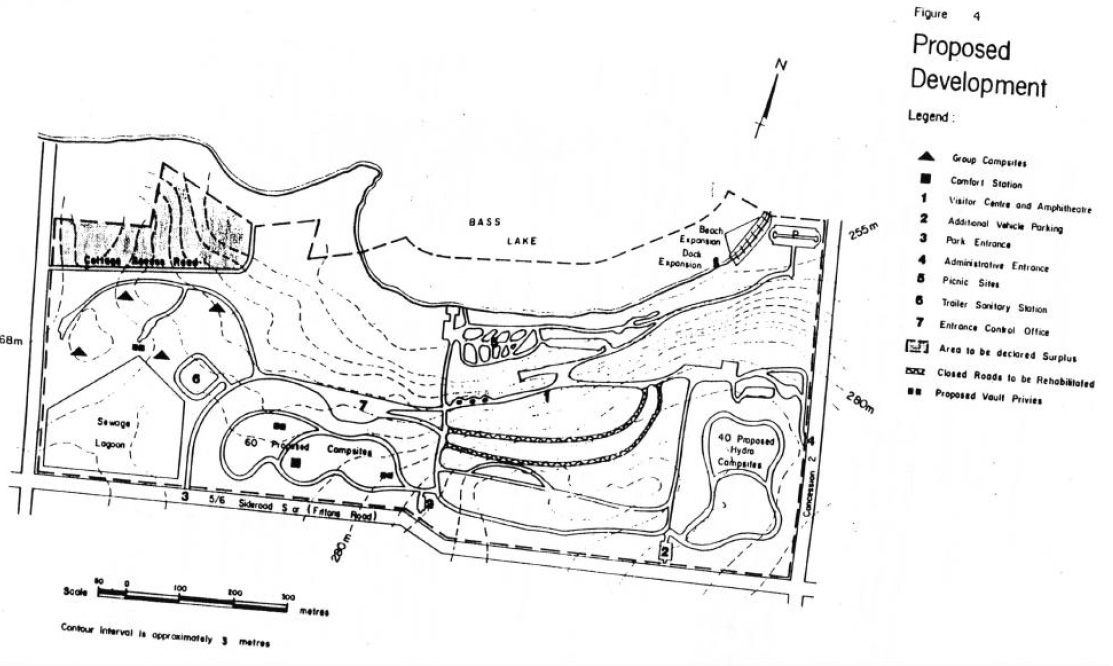
There is a five hectare section of parkland that is north of the cottage access road (Figure 4) that is surplus to the park needs. The area is not required for development and does not contain any significant natural or cultural features. It is therefore proposed that the area be declared surplus.
2.5 Zones and Zone Policies
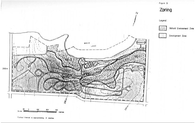
Bass Lake Provincial Park (including the 27 ha area to be added) contains two zones: Natural Environment and Development (Figure 3).
2.5.1 Natural Environment Zone Description
This 12 ha zone consists of two separate areas each containing representative biological resources. Zone NE1 (8 ha) contains a maple/beech forest community and supports a representative rich ground flora. It also features a segment of the glacial Lake Algonquin Bluff. Zone NE2 (4 ha) is situated adjacent to the lakeshore and north boundary and contains a cedar wetland.
Natural Environment Zone Policies
- to protect the vegetation and ancient shoreline from impact generated by park users by monitoring use of the area and imposing restrictions as required
2.5.2 Development Zone Description
This 48 ha zone presently contains mast park recreation, administration and maintenance facilities.
Development Zone Policies
To provide facilities to accommodate a wide range of recreation activities inclu ding water-oriented day use activities and camping as well as park administration, sewage treatment and maintenance functions. Development will be designed to limit environmental impacts on the land and water.
3.0 Resource Management
The park’s natural resources will be managed in accordance with the general planning and management policies for recreation class parks outlined in the Ontario Provincial Parks Planning and Management Policies. Although the policies in this section are presented in separate categories, all subsequent planning and management will recognize the need to integrate these components as they are all interrelated.
3.1 Vegetation Management
Vegetation management activities in the park will promote forest regeneration where appropriate, wildlife habitat and public safety. Commercial forest operations will not be permitted in the park. A vegetation management plan for the park will be prepared in consultation with district forest management, parks and fish and wildlife staff and according to vegetation management guidelines for parks.
Collection of data through research projects will be encouraged. In the past some re-planting was carried out to rehabilitate a former campground, which was located in a mature maple-beech forest. Projects may involve monitoring of the campsite rehabilitation program and the efforts to stimulate natural regeneration.
The swamp community adjacent to the lakeshore will require the removal of hazard trees along the walking trail.
Insects and diseases threatening the forest values of the park will be controlled using biological measures where feasible. Control will be directed as narrowly as possible.
Within the development zone, vegetative buffers will be established to improve the aesthetics of the park using only native tree species. The grassed area will be managed to maintain an aesthetically pleasing appearance. Non-native grass and legume species may be utilized.
A tree nursery has been established and will be maintained in the park to supply a stock of native tree species for the planting program.
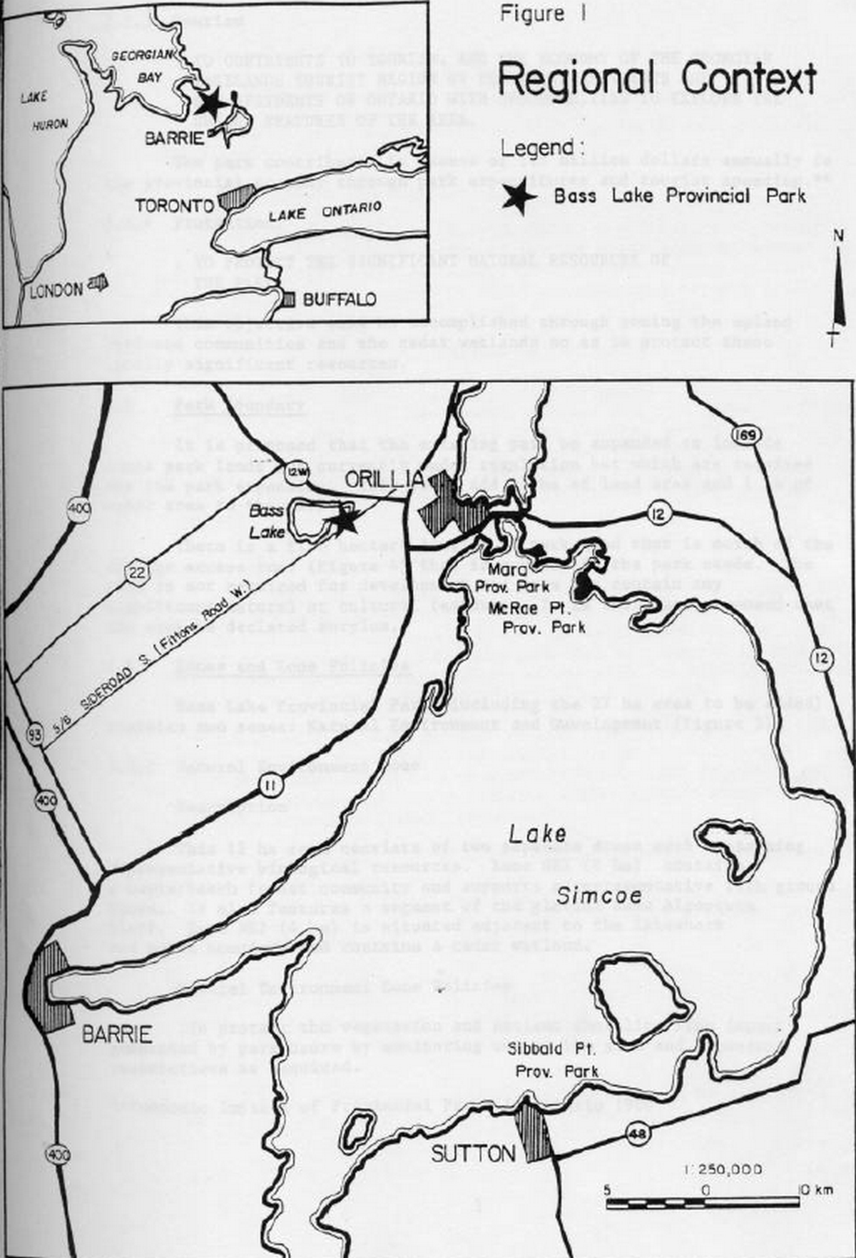
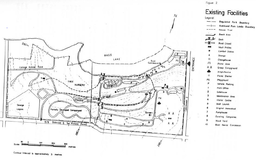
Figure 2: Existing Facilities
Enlarge Figure 2: Existing Facilities
3.2 Land Form and Water Management
Expansion of the beach facility (adding 40 m of beach) will require some modification of the existing shoreline including some removal of vegetation, alteration of the back shore slope and the addition of sand. Erosion along the new section of beach will be monitored and may necessitate the construction of protection works. Prior to any construction or beach expansion, a resource management plan would be prepared to assess the feasibility and impacts of the proposed works.
3.3 Fish and Wildlife Management
Sport fishing will be encouraged in Bass Lake through the provision of a boat launch and docking facilities. Fish populations in the lake will be monitored by district fish and wildlife staff since they are susceptible to major fluctuations due to fishing pressure and natural conditions. Commercial fishing and bait fishing will not be permitted in park waters.
Trapping will not be allowed except for control of nuisance animals carried out under the supervision of the ministry. Hunting will not be permitted in the park.
4.0 Client Services
4.1 Visitor Services
The goal of the Bass Lake Visitor Services Program is to provide visitors with a variety of recreational and interpretive opportunities through use of the park’s resources.
Emphasis will be on self-use facilities and programs. The district office will offer technical facilities and expertise to park staff. Bass Lake staff will provide guidance and assistance concerning visitor services to Mara and McRae Point.
Visitor services consists of the following three components listed in order of importance: information, recreation, interpretation.
4.1.1 Information:
Information concerning the park, the surrounding area and the policies and programs of the Ministry of Natural Resources must be delivered to the park user. This will be achieved using publications, newsletters, bulletin boards, displays and personal contact. The main facility associated with this component will be the visitor center.
4.1.2 Recreation:
Emphasis will be placed on self-use recreation facilities such as playfields, creative playgrounds, trails, a recreation equipment loan system and a small boat rental concession. Some staff led programs which focus on recreation skills such as fishing may be provided.
Recreation programming will be directed toward family groups and campers, however, day users will be encouraged to attend. Programming will occur in the summer, but self-use facilities will be available throughout the year.
4.1.3 Interpretation:
Delivery of interpretive messages will be limited to publications, self-use facilities and campsite visitations by park staff. Limited staff led interpretive programs will focus on three themes of local significance. These themes are earth science (Algonquin shoreline), past agriculture activities and water recreation (fishing. boating and swimming. Interpretive messages will be presented at the visitor center through a trail guide brochure, tabloid and bulletin board and poster.
Special programs for educational groups will not be provided at Bass Lake Provincial Park. However, the park may be used for outdoor education field trips with the permission of the park superintendent.
4.2 Recreation Management
The park operating season is normally from May to October. During the off season the public may use the park for such activities a hiking, cross-country skiing and snowshoeing. Parking is available at the park office.
4.2.1 Camping
Campsites located within a portion of the maple/beech forest will be monitored to determine the impact of their use upon regenerating vegetation adjacent to the sites. Periodic seasonal closure of the sites may be necessary.
4.2.2 Day Use
The popularity of the park’s day use facilities, especially the beach, will require careful monitoring to avoid overcrowding and a reduction in the quality of the park user’s recreational experience.
Campers are expected to utilize approximately half of the beach area and parking area at any one time.
4.3 Commercial Services
The existing concession will provide small, non-motorized watercraft for rent to park users. This commercial operation is located adjacent to the lakeshore within the day use area.
Another concession will provide firewood to campers from a fence woodyard located adjacent to the parks maintenance facility.
Two small convenience stores located within one kilometre of the park will provide users with food items and a limited range of camping supplies. Other concessions compatible with the parks goal and objectives will be considered.
4.4 Marketing
The marketing strategy for Bass Lake Provincial Park will focus on the following items listed in order of priority:
- increase day use (particularly during the week) by raising the park profile locally
- improve occupancy rate during the shoulder season by encouraging return visits from current customers and emphasizing the benefits of spring and fall camping
Figure 3: Zoning
5.0 Development
In all instances detailed site plans will be completed and approved in advance of any development. The requirements of the Environmental Assessment Act will be followed.
5.1 Access and Entrance Control
The main entrance to the park will be relocated so that visitors will approach the park by a safer and more direct route. The new entrance will be located on the 5/6 sideroad S. (Fittons Rd), Figure 4.
The road from the main entrance will lead directly to the entrance control office (Figure 4). Here, visitors will be directed to either camping or day use areas. The office will be large enough to distribute pamphlets, newsletters and information concerning the park and other points of interest.
A secondary entrance to the park will be provided from Concession Road Two. It will provide access to the park administration office and nearby parking lot. This entrance will be used by visitors participating in winter activities or seeking information on fish and wildlife matters or park policy.
To lower maintenance costs and control dust, all roads will be hard surfaced.
5.2 Camping Areas
The ten year average July-August occupancy rate at Bass Lake, of 86% indicates a need for additional campsites. Bass Lake was identified as a park that had the potential to develop additional campsites (Huronia District Land Use Guidelines, 1983). It is therefore proposed that 100 campsites be added to the park. To accommodate this expansion, four existing group campsites will be relocated. The expansion and redevelopment of the campsites will result in greatly improved utilization of the available park area.
The east campground will contain the existing campsites (80 sites) in addition to 40 new sites to be developed within the existing group campground. The new sites will be serviced with electrical hook-ups because of the demand for electrical sites in the park. In the west campground 60 new sites will be developed.
Parking for 10 additional vehicles will be provided within each of the campgrounds.
Communal facilities in each campground will include; a comfort station with showers, vault toilets and washbasins, drinking water and a small play area. The existing campsites in the maple/beech woodlot will require special attention and management practices to ensure that over use does not damage vegetation and soils.
Group camping activities will be located in a five hectare area at the west end of the park. This area will be capable of accommodating four separate group camping sites. Each site will have a tent area for sleeping, eating and assembling plus a play area. The camping area will also contain a common play area for field games and vault toilets with wash basins.
5.3 Day Use Facilities
5.3.1 Beach Area
The beach at Bass Lake has traditionally been subjected to intensive use. The increase in the number of campsites will undoubtedly place a much greater demand upon the facility. For this reason the beach will be lengthened by 40 meters.
5.3.2 Picnic Areas
Picnic sites will be provided in an area bounded by the boat launch in the west and the park boundary in the east. Existing campsites in the west end of this area will be converted to picnic sites. Existing picnic shelters will be retained for group use and inclement weather.
5.4 Visitor Centre and Amphitheatre
Although not a high priority, a new visitor centre and amphitheatre should be built. (Figure 4) All facilities will be incorporated into one building, including workspace for visitor services staff.
5.5 Boat Launch and Dock
The existing boat launch is to be maintained while docking facilities are to be expanded in conjunction with the development of the boat rental concession.
The existing parking lot at the boat launch will be sufficient to accommodate users of this facility. Users of the boat rental concession will use the other day use area parking facilities.
5.6 Trails
The self-guiding walking trail will be maintained to provide opportunities for recreation/interpretation. In addition to summer season walking the trail will be utilized for winter activities, especially cross-country skiing. The closed roads through the upland hardwoods (Figure 4) will be rehabilitated to a natural state with some of the road used for the trails system.
Existing walking trails between the campground and beach areas will require maintenance to prevent further erosion and damage to vegetation. New trails between the west campground and beach will be constructed so as to localize the impact of the impact of foot traffic between these two facilities.
Figure 4: Proposed Development

Enlarge Figure 4: Proposed Development
5.7 Maintenance Facilities
Major maintenance facilities will consist of:
- 3 bay maintenance building (existing)
- flammable materials storage building (existing)
- unheated storage building (existing)
The buildings will remain in their current location immediately north of the east campground. This location has been selected because it will permit the use of existing buildings and it is readily accessible to the concession road and the park office.
5.8 Sanitary Facilities
The park will contain four comfort stations, three existing (one with showers) and one to be built (with showers) in the west campground and six vault toilets. All sewage will be treated in two sewage lagoons located in the southwest corner of the park. The lagoon system was constructed to standards, which exceed the demands that will be placed upon it by the expanded facilities.
Sewage will be transported to the lagoon from the comfort stations and trailer dumping station via an expanded underground pipeline system and from the vault toilets by truck.
The new trailer dumping and filling stations will be constructed west of the entry control office.
Solid wastes will be managed by a private waste management company utilizing two centrally located garbage receptacles.
6.0 Implementation Strategy
Development of facilities in Bass Lake Park is largely dependent upon the availability of funding. For that reason it is impossible to predict development will occur. However, as funding becomes available, the proposed works will be implemented in a logical, cost efficient manner, based upon the list of development projects below.
The area of the park required for the park expansion will be placed under regulations as soon as possible. The area north of the cottage access road not required by the park will be declared surplus.
In 1985 the Ministry of Natural Resources contributed to the cost of reconstruction and surface treatment on Fitton’s Road (Number 5 Sideroad). This project improved the future park access road to county road standards from Concession 2 to the future park entrance.
The list of development projects, in order of priority, is as follows:
- Construct new entrance control office. This will involve installation of telephone and electrical service and water and sewage system
- Construct new comfort station with showers to service west campground and group camping sites and connect the station to existing sewage pipeline. Electrical service will be required
- Construct new water pumping and treatment facility and install new water lines in east and west campgrounds and group campground and install hydro service to 40 campsites in east campground
- Construct four new group campsites
- Construct road system and campsites for 40 new sites in east campground and 60 campsites in west campgrounds
- Construct three new vault toilets
- Construct 40 metres of new wet and dry beach and convert the campsites adjacent to the lake to picnic sites
- Hardsurface all internal park road
- Construct trailer dumping and filling station
- Rehabilitate the closed roads through the upland hardwoods
- Construct new visitor services building and amphitheatre
7.0 Summary of Public Consultation and Plan Review
Public consultation during the management planning process for Bass Lake Provincial Park occurred during the summer of 1985 and focused on the local area. It included the following:
- Copies of the preliminary plan and a news release were sent to the local municipalities, interest groups and MPP's
- A news release was sent to the local news media and resulted in several newspaper articles and radio interviews
- A fact sheet was prepared that summa rized the proposals in the management plan and included a map. Approximately 200 copies were distributed primarily to park users
- All comments and suggestions received from the public were considered while finalizing this plan
This management plan will be reviewed when major issues surface or at least once within the next ten years. Plan amendments will be made following the appropriate level of public consultation.
8.0 References
Carlisle, Robert ~ Bass Lake Provincial Park Geological Assessment, MNR 1973
Cordiner, George; M Evaluation of Earth Science Features in Parks, Park Reserves and Special Areas of Central and Southwestern Regions, MNR 1977
Grins, William; A Reconnaissance Biological Inventory of Bass Lake Provincial park, MNR 1982
Harris, Rosalind, E. Interpretive Prospectus for Bass Lake Provincial Park, MNR 1973
Ontario Ministry of Natural Resources; Bass Lake Provincial Park Preliminary Master Plan, MNR 1978
Ontario Ministry of Natural Resources; Bass Lake Provincial Park Resource Inventory, MNR 1977
Ontario Ministry of Natural Resources; Ontario Provincial Parks Planning and Management Policies , 1978
Ontario Ministry of Natural Resources; Ontario Provincial Parks Statistics, 1973-1983
Ontario Ministry of Natural Resources; First Draft Provincial Parks Systems Plan Central Region, 1979
Ontario Ministry of Natural Resources; Huronia District Land Use Guidelines, 1983