Batchawana River Provincial Park Management Statement
This document provides direction on the management of Batchawana River Provincial Park.
Interim, Management Statement, 2006
Approval Statement
I am pleased to approve this Interim Management Statement for Bachawana River Provincial Park. Ontario’s Living Legacy Land Use Strategy (1999) identified this area as a waterway class provincial park. This provincial park was regulated under the Provincial Parks Act in 2004 (O. Reg. 178/04).
This Interim Management Statement provides direction for the protection and custodial management of Batchawana River Provincial Park.
Paul Bewick
Zone Manager
Northeast Zone
Ontario Parks
Date: November 29, 2006
1.0 Introduction
Batchawana River Provincial Park is located 90 kilometres north of Sault Ste Marie and 40 kilometres southeast of the town of Montreal River Harbour (Figure 1).
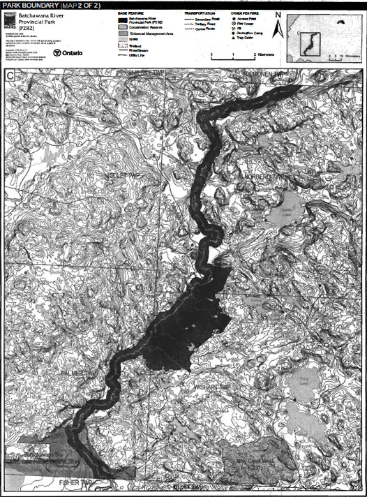
The waterway flows out of the northeast uplands of Batchawana Ecodistrict (5E–13) southwest across the ecodistrict and consists of two sections of Crown land. A natural heritage area forms the upper section in Palmer, Wishart and Norberg townships; the lower section in Runnalls Township includes a 200 metre limit along both sides of a length of the river which is connected to another natural heritage area (Figures 2a and 2b). These two sections are separated by private land that includes the Algoma Central Railway (ACR) crossing. The park is approximately 2,684 hectares in size.
Designated through Ontario’s Living Legacy Land Use Strategy (OMNR 1999), the park was regulated under the Provincial Parks Act in July of 2004 (O. Reg.178/04). The purpose of the waterway designation within the context of the provincial park system is to protect a representative river that can provide quality recreational and educational opportunities.
The purpose of this Interim Management Statement (IMS) is to provide direction to allow custodial management of park resources.
1.1 Objectives
Batchawana River Provincial Park will be managed consistent with the four objectives for provincial parks:
Protection: To protect provincially significant elements of the natural and cultural landscapes of Ontario.
Recreation: To provide provincial park outdoor recreation opportunities ranging from high–intensity day–use to low–intensity wilderness experiences.
Heritage Appreciation: To provide opportunities for exploration and appreciation of the outdoor natural and cultural heritage of Ontario.
Tourism: To provide Ontario’s residents and out–of–province visitors with opportunities to discover and experience the distinctive regions of the Province.
2.0 Management Context
Park management will follow direction from:
- Provincial Parks Act (1990) and regulations
- Ontario Provincial Parks Planning and Management Policies (OMNR 1992) and updates
- Ontario’s Living Legacy Land Use Strategy (OMNR 1999) and policy clarifications (OMNR 2000), amendments, and related direction
- Crown Land Use Policy Atlas (OMNR 2004a) and amendments
In addressing custodial management obligations to protect park values and ensure public health and safety, Ontario Parks will ensure that policy and Environmental Assessment Act (1990) requirements are implemented.
Figure 1: Regional Setting
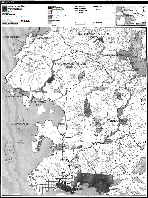
Figure 2a: Park Boundary (Northeast Section)
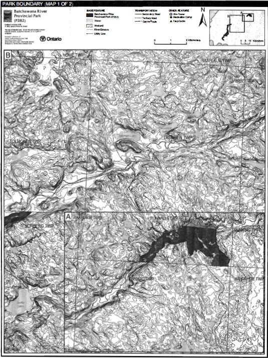
Figure 2b: Park Boundary (Southwest Section)
2.1 Environmental Assessment
As part of the Ontario Ministry of Natural Resources (MNR), Ontario Parks is a public sector agency that is subject to the Environmental Assessment Act. Park management will be carried out in accordance with legislation, policies, and guidelines that are required under MNR's A Class Environmental Assessment for Provincial Parks and Conservation Reserves (OMNR 2005a).
3.0 Park Features and Related Values
Two sections of the Batchawana River are included in this waterway park. In the upper section the park includes the Batchawana East natural heritage area, and in the lower section it has the Batchawana–Turkey Lake natural heritage area. Being a navigable river, the recreational canoe route and Crown bed and islands of the river connect the two Crown land sections.
Batchawana River Provincial Park is the only protected waterway class park of the many small rivers that drain into Lake Superior from the southern Precambrian Shield in Ecodistrict 5E–13. The headwaters occur in the rugged uplands east of the upper limits of the park and include lands within Algoma Headwaters Provincial Park.
3.1 Geological Features
Batchawana River Provincial Park lies within the Batchawana greenstone belt. The river crosses rock derived from sedimentary deposits in its northeastern section, and metavolcanic rock in the southwest. At the extreme southwest end of the park, rocks at the edge of the greenstone belt are in contact with granitic rock. The latter are intruded by younger diabase dikes that cross–cut rocks of the Batchawana greenstone belt. Major fracturing and faulting occurred in the underlying greenstone rocks resulting in a linear valley, in which the Batchawana River flows from its upper reaches within the park in Runnalls Township to the lower end in Palmer Township. Copper mineral deposits have been found in the greenstone rocks in this area.
Sand and gravel, glaciofluvial outwash or valley train deposits were left by glacial meltwater in this fault–controlled river valley. In its upper reaches, the river meanders in a narrow alluvial plain, constrained on either side by high bedrock valley sides. In mid sections, the modern river has cut into the sand and gravel outwash deposits. At the park’s lower west end, in Palmer Township, the valley widens as it levels out on coastal glaciolacustrine deposits at the mouth on Lake Superior.
Batchawana River Provincial Park is within a representative section of a fault–controlled valley with greenstone bedrock outcrops. Because it is one of only two protected areas that preserve portions of the Batchawana greenstone belt (the other being P273 Algoma Headwaters Provincial Park) and no other greenstone belts either exist or are protected in this general area, bedrock geology of the park is regionally significant (Blackburn 2004).
The fault–controlled valley, which was filled with glacial outwash and now has straight and meandering river course sections in an alluvial plain between high bedrock hills in Runnalls Township, is a good example of this landform type and is therefore regionally significant (Blackburn 2004).
3.2 Biological Features
Batchawana River Provincial Park extends roughly northwest to southeast through a cross–section of habitats in Batchawana Ecodistrict 5E–13. Along the course of this fault–controlled river it passes bedrock outcrops and glacial terraces that are open with no or very little vegetation, to widenings with river shoreline wetlands, and bottom land to areas that have deeper soils and upland forests. Typical Great Lakes–St. Lawrence transition forest of tolerant hardwoods and mixed woods cover the majority of the land base. Logging occurred during the 20th century within the area now regulated as park.
Batchawana–Turkey Lake and Batchawana–Batchawana East natural heritage areas are within the park. These areas' steep bedrock hills and upland ground moraine, tracks flank river valley outwash deposits. Old Sugar Maple and Yellow Birch stands and mixed forests of Sugar Maple with White Pine, White Spruce and Eastern Hemlock are the dominant forests. This park also supports populations of some species of concern including Northern Holly–Fern and the provincially rare Braun’s Holly–Fern.
The river can have strong freshet outflows in May and June with quite low flows in the summer period, which is typical for this size of river on the southern Shield.
Populations occur in the river and many adjacent lakes.
3.3 Cultural Setting
There has been no cultural survey of the Batchawana River Provincial Park. Some raised glacial beach terraces may show significant pre–contact First Nation use. Other post–contact uses need to be assessed.
Future planning will define cultural heritage in the context of a provincial framework, A Topical Organization of Ontario History (OMNR 1974). In addition, updates and discussions with First Nations, other agencies and stakeholders may be carried out to identify cultural heritage values and features within the park and their significance. This information may be used to develop management guidelines to conserve and protect representative archaeological and historical values and features, or to provide direction for further research.
3.4 Recreation
Activities recorded in Batchawana River Provincial Park include canoeing and river kayaking, camping, viewing landscapes and exploring, portaging, fishing, shore lunches, camps (cottaging), hunting and all–terrain vehicle (ATV) use.
Multiple day downstream canoe / river kayaking trips occur on the Batchawana River. The Batchawana River Canoe Route describes a trip mid–way to the park lands from Batchawana Railway Station, either from visitors travelling by rail from the Sault Ste. Marie ACR line or off bush roads with canoeists / river kayaks travelling downstream to Lake Superior. Day trips occur from the mouth, or off the Tribag Road, or in mid–stream reaches from Batchawana Station and camps along the river there, or from adjacent lakes such as a fly–in outpost camp on Lawrence Lake, or from bush roads in upper reaches such as along the hydro corridor in Scriven Township. Extended river canoe travel can begin upstream–in Moen Township with trips covering 110 kilometres to Lake Superior (Harper and Carre 2002, Kershaw 2002, Morris and Knudsen 2002).
Motor boating occurs in the mouth area and up and downstream short distances from Batchawana Station at the ACR crossing. Motor boats do not travel beyond sections of deep water between rapids in these areas.
Hunting occurs according to prevailing regulations for small and large game.
ATV travel occurs on existing bush roads and unofficial trails within the park in association with hunting, fishing and camp use. There are no authorized ATV or snowmobile trails or crossing in the park.
4.0 Aboriginal Uses
Batchawana River Provincial Park lies within the Robinson–Superior Treaty of 1850 and is located just north of the Ojibways of Batchewana and the Garden River.
Discussions regarding the regulation of Batchawana River Provincial Park occurred with the Batchawana, Garden River, Mississauga, Serpent River and Thessalon First Nations, and the North Shore Tribal Council (OMNR 2001a). Aboriginal communities have used the area for hunting, trapping, fishing, gathering and travel. These uses may continue, subject to public safety, conservation and other considerations.
Ontario Parks will continue to communicate and work with Aboriginal communities through future planning for and management of the park. Any communications and cooperation between Aboriginal communities and MNR for planning and management purposes will be done without prejudice to any future discussions or negotiations between the Government of Ontario and Aboriginal communities.
5.0 Stewardship Policies
The removal, damage or defacing of Crown property, natural objects, relics and artifacts is not permitted in provincial parks (Provincial Parks Act).
Non–native species will not be deliberately introduced into the park. Where non–native species are already established and threaten park values (i.e. has become invasive), a strategy to control the species may be developed (OMNR 1992).
5.1 Terrestrial Ecosystems
5.1.1 Vegetation
Harvesting
Commercial forest operations are not permitted within the park (OMNR 2004a).
There is no existing authorized wild rice harvesting. New operations will not be permitted.
New commercial harvesting of non–timber forest products (e.g., Canada yew, etc.) will not be permitted within the boundary of Batchawana River Provincial Park (OMNR 2004a).
There are no fuel wood cutting permits currently issued for the park. No new permits will be issued (OMNR 2000; 2004a).
Insects and Disease
Insects and diseases may be managed where the aesthetic, cultural, or natural values of the park are threatened (OMNR 1992). Controls will follow guidelines established by the Ontario Ministry of the Environment (MOE) and MNR. Whenever possible, biological controls will be given preference over the use of chemicals (OMNR 1992).
Fire
In accordance with existing provincial park policy and the Forest Fire Management Strategy for Ontario, forest fire protection will be carried out in the park as on surrounding lands (OMNR 2004a). Whenever feasible, MNR's Forest Fire Management program will use techniques which minimize damage to the landscape such as limiting the use of heavy equipment or limiting the number of trees felled during response efforts (OMNR 2004b).
5.1.2 Wildlife Management
Batchawana River Provincial Park is located within Wildlife Management Units 35 and 36. Removal or harassment of non–game animals is not permitted (Provincial Parks Act).
Hunting
Sport hunting is permitted to continue. Considerations of safety and conservation with respect to hunting may be made through future management planning, which will include public and Aboriginal consultation (OMNR 2000a).
The Fish and Wildlife Conservation Act (1999), as well as the Migratory Birds Convention Act (1994), governs any hunting activity within this provincial park. The Ontario Hunting Regulations Summary contains regulations specific to this area. The harvesting of bullfrogs or snapping turtles is illegal in provincial parks.
Bear Management Areas
Batchawana River Provincial Park includes portions of two bear management areas (BMA); one is active SS36–001, while the second is vacant SS36–002. The rest of the park, including the entire north section, is unallocated (Figure 3).
Existing commercial bear hunting operations are permitted to continue. This activity may be subject to conditions identified during future management planning (e.g., the designation of nature reserve zones).
No new BMA licences will be issued.
Renewal and transfer of the existing licences will be addressed through management planning and will consider conservation principles and public safety (OMNR 2000; 2004a).
Trapping
Existing commercial fur harvesting operations may continue where the activity has been licensed or permitted since January 1, 1992. New operations, including trap cabins and trails, will not be permitted (OMNR 2000a; 2003).
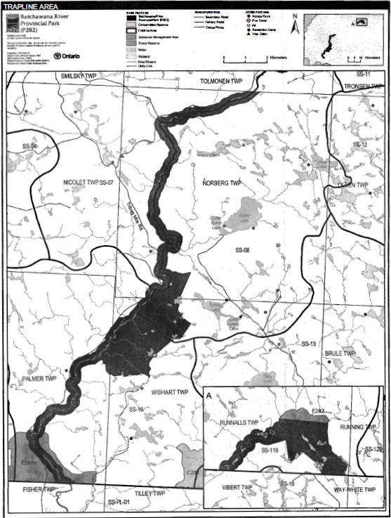
There are portions of four licensed trap lines included in the area of this park: SS07, 8808, S809 and WA119. Trap line SS–18 is adjacent to the north section of the park (Figure 4).
Transfers of active trap line licenses are permitted, subject to a review of potential impacts and the normal transfer or renewal conditions that apply1.
Figure 3: Bear Management Areas
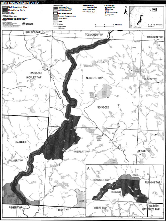
Figure 4: Trap Line Areas
5.1.3 Industrial Resources
There are no licensed aggregate pits (active or inactive) located within the boundary of Batchawana River Provincial Park. Aggregate extraction is not permitted in provincial parks (OMNR 1992).
There are no existing mining claims within the park. Mining and surface rights on all lands within the park have been withdrawn from staking under the Mining Act (1990). Mineral exploration and mineral extraction are not permitted in the park (OMNR 1992).
In accordance with Ontario’s Living Legacy Land Use Strategy (OMNR 1999), access through the park to mining lands (i.e. forest reserves and mining patents) will be permitted for purposes of mineral exploration, development or operations. Access will be planned in accordance with the requirements of the Environmental Assessment Act.
5.1.4 Access and Crossings
Access
Batchawana River Provincial Park is currently accessed by railway, automobile, all–terrain vehicle (ATV), canoe, motor boat, snowmobile and hiking.
The park is smaller than the extent of the Batchawana River; the boundary has two distinct sections. Persons travelling on the river will likely start outside the park and depending on the length of their trip, they will be in and out of the park as they canoe down the river.
Given the fragmented nature of the boundary and being a waterway that attracts river travel, the most common way of entering the park is by canoe. The existing Batchawana River Canoe Route describes a trip from Batchawana Railway Station to Lake Superior. This description covers only the lower section of the lands and waters that are within the park. The ACR rail line, several forest access roads and a service road along a hydro corridor provide indirect access to the upper section of this park.
Aircraft cannot land on the Batchawana River as it is too small, but floatplanes do land on lakes adjacent to the river, such as Lawrence Lake in McParlane Township, and thus shuttle canoeists to waters that lead to the park.
Roads
Trails and road access along most of the lower reaches of the river were established when logging occurred in the Batchawana River valley during the 20th century.
Today, Tribal Road is u
This road occurs on the west side of the river in Palmer, Wishart, and Norberg townships. The road is a primary road in the forest management plan. Road construction required blasting of rock in one location to make room for single vehicle passage; this is beside a very scenic small canyon on the river. The road is subject to washouts with gravel and waste rock getting into the (Kershaw 2002).
The northern section of this park is inaccessible by road. A separate tertiary road system to the east has roads and trails leading near to, and in some places entering the park. Upstream of the upper section of the regulated park boundary, there is a hydro crossing in Scriven Township where a rough hydro service road affords access to the Batchawana River.
Where existing forest access roads are essential for continued access beyond the park for forest management or recreation purposes, and alternative road access does not exist, or road relocation is not feasible, existing roads will continue to be available for access. Continued use will include maintenance and may include upgrading (OMNR 2004a). Ontario Parks is not responsible for maintenance or upgrading of any existing roads within the park boundary.
Any proposed development or maintenance/upgrading of existing roads must meet all Environmental Assessment Act requirements.
Aggregate resource extraction is not permitted within parks. Aggregate cannot be obtained from inside the park for road improvements and maintenance.
Railway
There are no railway crossings of the park boundary. However, the Algoma Central Railway (ACR) crosses through private lands at Batchawana Station, between the upper and lower portions of the park.
Utility Corridors
There are no utility corridors crossing the park.
All public utilities (e.g. gas pipelines, transmission lines, communications towers) must avoid park lands wherever possible. New utility corridors may be necessary to maintain essential public services (OMNR 2004a).
Any future utility corridors proposed through the park, where park lands are unavoidable, will be reviewed on a case–by–case basis. Protection of park features and values will be priority and all requirements of the Environmental Assessment Act will be met.
Recreation Trails
Canoe Route: Batchawana River Canoe Route passes through the lower part of this park. This trip begins at Batchawana Station and ends at Lake Superior at Highway 17. There are accounts of travel on the river above Batchawana River Station where canoeists have entered the river and the upper portion of the park from adjacent areas such as from a hydro crossing in Scriven Township. Portages and campsites along the way are not marked or maintained. Spring freshets typically create the best water levels in May and early June. MNR deems this route "hazardous" (OMNR no date) due to the many falls and rapids; canoeists require advanced travel skills.
All–Terrain Vehicles: There are no designated ATV trails in Batchawana River Provincial Park. Unauthorised ATV travel occurs on existing resource access roads and unofficial trails within the park as associated with hunting, fishing, and camp use (Kershaw 2002). ATV use of unauthorized trails is not permitted.
Snowmobiles: There are no authorized snowmobile trails or crossings in' Batchawana River Provincial Park. Snowmobile use on existing routes for access to private land in–holdings, LUPs, and recreational ice fishing may continue unless park values are threatened. Proposals for new trails may only be considered through future planning with public and Aboriginal consultation (OMNR 2000a).
Hiking: There are no designated hiking trails in Batchawana River Provincial Park at this time.
If there is an identified need, the development of new hiking trails may be considered. Trail infrastructure to protect park values and features will be permitted. Any proposed development within the park is subject to Environmental Assessment Act requirements.
5.1.5 Adjacent Land Management
Forestry
Crown land adjacent to the park is located within Algoma Forest Management Unit (FMU# 615). MNR works with the sustainable forest licensee to manage the forest on Crown land. Adjacent private lands in Running, Vibert, Tronsen and Tolmonen townships, are managed primarily for forestry.
Provincial Parks
Batchawana Provincial Park is a small recreation class park located to the east of the mouth of the river, approximately five kilometres southwest of the waterway park. This regulated park encompasses 169 hectares of Crown land.
Forest Reserves
Forest reserves (FR) are areas where protection of natural heritage and special landscapes is a priority; some resource use can take place with appropriate conditions. Policies for FRs and conservation reserves are similar, except that mining and related activities will be allowed in a forest reserve. Commercial forest harvest, new hydroelectric power development, and peat extraction will not be allowed, but most other resource and recreation uses will be permitted, provided they are consistent with the features and values being protected (OMNR 1999).
Batchawana River FR (F282) is adjacent to the northern section of the park and consists of an active mining claim. This land is not included in the regulated area of the park. As described in the proposed strategy for FRs (OMNR 2005b), this FR designation will be removed from all mining lands at the site and will be redesignated as a General Use Area.
Enhanced Management Areas
Enhanced Management Areas EMAs) are a land use category established through Ontario’s Living Legacy Land Use Strategy to provide more detailed land use direction in areas with special features or values (OMNR 1999). Batchawana Bay–Carp Lake Raised Delta EMA (E280n) connects to the southern section of the park in Palmer Township. This EMA encompasses 730 hectares of Crown land and contains two significant natural features, a 5,000 year old glacial shoreline called the Nipissing Bluff and the Carp Lake raised delta (Blackburn 2004).
This recreational and resource sector area allows for forest management provided that it is consistent with the protection of earth science values. Aggregate extraction will be directed to minimize impacts to earth science values. There may be an opportunity to enhance fisheries management (OMNR 2004).
Land use direction and resource management activity in the EMA will be compatible with protecting natural and recreational values of the park (OMNR 2004).
General Use Area
General use areas adjacent to Batchawana River Provincial Park include Batchawana General Use Area (G1908) encompassing 178,151 hectares of Crown land, and Integrated Multiple Resources Management Area (G2069) encompassing 44,233 hectares of Crown land (OMNR 2004a). The intent for the Batchawana General Use Area is to manage the area for public recreation. All other land uses will be permitted in this area; however, site specific restrictions may be imposed on activities where Crown land recreation facilities are developed and around critical fish habitat. The land use priorities in the Integrated Multiple Resources Management Area G2069 are forest management, mineral exploration, mining, hydroelectric power generation, tourism and Crown land recreation (OMNR 2004a).
5.1.6 Land Disposition
Batchawana River Provincial Park is located in Palmer, Wishart, Norberg, and Runnalls townships in the Sault Ste. Marie MNR District.
New land disposition for the private use of individuals or corporations will not be permitted (OMNR 1992; 2000).
Land Use Permits, Licenses of Occupation, Unauthorized Occupations
Seven land use permits (LUP) have been issued within or adjacent to the boundary of Batchawana River Provincial Park. AU of these permits are issued for private recreation camps (Norberg Township: 3; Wishart Township: 3; and Palmer Township: 1).
Existing authorized LUPs for recreation camps may be eligible for enhanced tenure but not the purchase of land. Recreational camp LUPs cannot be changed to commercial LUPs unless this is supported during a review as part of park management planning. Enhanced tenure, is defined as a possible extension of the term of the LUP for recreation camps up to 10 years or upgrade in tenure (i.e., LUP to lease) (OMNR 2000a).
Enhanced tenure for an LUP for a recreation camp is not guaranteed. Requests for enhanced tenure, or to transfer recreation camps, will be reviewed based upon the following criteria:
- Continued compliance with the conditions of the LUPs for recreation camps
- Current land disposition policies for LUPs
- Consistency with park objectives to sustain values – no effects on heritage values and/or conflict with other uses
- Consistency with Aboriginal land claim negotiations or protocol. agreements
- All rents, taxes, fees, rates, or charges are paid and in good standing
An extension in the term of tenure for an existing private recreation camp LUP does not convey a commitment to provide for a change in the type or the standard of existing access to the private recreation camp.
There are no known licenses of occupation or unauthorized occupations within this park.
Patent Land
The Batchawana River flows through Crown land and several patent townships including Running, Vibert, Tronsen, and Tolmonen (Algoma Central Railway, 1980). The private lands were established through a grant as incentive to develop rail services in the north at the tum of the 20th century. The land title process enabled the then 'Central and Hudson Bay Railway Company' to establish extensive rail service in Algoma District. Conditions were placed on the original patents to ensure future public passage down the Batchawana River, thus recognizing navigability and the river’s heritage as a travel route (Kershaw 2002).
Recreational use through the private townships is facilitated by a statement in the patent "Description of Regulation Number 58612 C.L.S." to the private land about a reserve on private land shorelands:
"… Grant to the Central and Hudson Bay Railway Company all those parcels of land in the District of Algoma … saving and excepting and reserving unto Us, Our Heirs and Successors for free use, passage and enjoyment of, in, over and upon all navigable waters which shall or may hereafter be found on or under or be flowing through or upon any part of the said parcels or tracts of land hereby granted as aforesaid and reserving also right of access to the shores of all rivers, streams and lakes for all vessels, boats and persons, together with the right to use so much of the banks thereof not exceeding one chain2 in depth from the waters edge as may be necessary for fishery purposes of for driving logs and timber and reserving five percent of the acreage hereby granted for roads and the right to layout same where the Crown or it’s officers may deem necessary."
MNR legal council determined that based on the fact that the river is navigable, that ownership of the river bed and islands in the private townships was retained by the Crown at the time of the original land grant to Central and Hudson Bay Railway Company (OMNR, 2001b).
Private lands are not included in the park and, as such, the policies and legislation of the Provincial Parks Act do not apply.
Waste Site
There are no authorized waste disposal sites in Batchawana River Provincial Park or on adjacent lands.
Boat Caches
There are no known authorized boat caches located within the boundary of Amable du Fond River Provincial Park. Boats are not permitted to be left unattended in the park without written permission from the superintendent under the authority of the Provincial Parks Act.
5.2 Aquatic Ecosystems
Sustaining quality water resources is integral to the protection of park and adjacent land values. MOE enforces applicable legislation and regulations for water quality.
5.2.1 Water Management
There are no existing water control structures within Batchawana River Provincial Park. Nor are there any such structures elsewhere on the Batchawana River. It is truly a free flowing river.
No new hydroelectric developments will be permitted in Batchawana River Provincial Park (OMNR 2000).
Alternative non–commercial energy proposals (e.g. small scale hydro, wind, and solar) for in–park use will be evaluated through future park planning, including full public and Aboriginal consultation.
5.2.2 Fisheries Management
Fisheries management will complement the maintenance and enhancement of native, self-sustaining fish populations.
Spring–fed brooks along the river serve as nursery grounds to support brook trout populations within Batchawana River Provincial Park.
Sanctuaries
There are currently no fish sanctuaries located within the park boundary. Certain water bodies may be closed to fishing temporarily or permanently for fisheries research or management purposes (OMNR 1992).
Sport Fishing
Sport fishing is permitted within the park. This activity is governed by legislation and regulations in the Fish and Wildlife Conservation Act and the Fisheries Act. The Recreational Fishing Regulations Summary contains details on regulations which are applicable to this area.
Commercial Fishing
There are no commercial fishing operations within the park. New operations will not be permitted (OMNR 2000).
Commercial Baitfish Harvesting
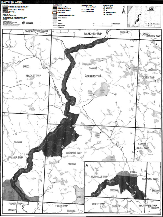
Norberg (SM 0032) and Wishart (SM 0050) townships are currently allocated for commercial bait fish harvesting to First Nations (Figure 5). Palmer (SM 0049) and Runnafls (SM 0006) townships are not currently allocated (Harper and Carre 2002). These townships may be allocated only if there is a record of activity since January 1, 1992 (OMNR 2003).
Existing commercial baitfish harvesting may continue where the activity has been licensed or permitted since January 1, 1992. This activity may be subject to conditions identified through future park management planning or fisheries management plans. New baitfish licenses will not be permitted (OMNR 2000; 2003b).
Fish Stocking
The stocking of native fish species may be considered through park management planning, with full public and Aboriginal consultation. Non–native fish species will not be deliberately introduced into park waters (OMNR 1992).
6.0 Operations Policies
6.1 Recreation Management
Future planning with full public and Aboriginal consultation will review direction on motorized and non–motorized recreation activities.
6.1.1 Motorized Recreation
Motorboats
The use of motorboats is permitted to continue, unless park values are threatened (OMNR 2004a).
Snowmobiles
There are currently no authorized snowmobile trails located within the boundary of Batchawana River Provincial Park. Snowmobile use on established routes for access to private land in-holdings, LUPs, and recreational ice fishing may be permitted to continue unless such trails threaten park features and values, create user conflicts or raise safety/liability issues.
Proposals for new trails may only be considered through future planning. with public and Aboriginal consultation (OMNR 2000).
Off–trail snowmobile use is not permitted.
All–Terrain Vehicles
There are no authorized all–terrain vehicle (ATV) trails located within the park.
The use of ATVs on established routes for access to private land in–holdings and LUPs may be permitted to continue unless such trails threaten park features and values, create user conflicts or raise safety/liability issues. Proposals for new trails may only be considered through future planning with public and Aboriginal consultation (OMNR 2000).
Off–road or off–trail use of ATVs will not be permitted within park boundaries unless authorized by the park superintendent under the authority of the Provincial Parks Act.
6.1.1 Non–Motorized Recreation
There are currently no developed camping facilities within Batchawana River Provincial Park. Some unmanaged campsites that are used in conjunction with the canoe route and road access.
Camping
There are currently no developed camping facilities within Batchawana River Provincial Park. Some unmanaged campsites that are used in conjunction with the canoe route and road access.
Figure 5: Commercial Baitfish Harvesting
Ontario Parks may assess the condition of existing campsites and will maintain, rehabilitate, or close sites as required. If there is an identified need, new campsites may be considered (OMNR 2004a). Infrastructure will be permitted in order to protect park features and values in response to use environmental deterioration and environmental protection requirements. Any proposed development in the park must fulfill the requirements of the Environmental Assessment Act.
Hiking
There are no designated hiking trails in Batchawana River Provincial Park.
If there is an identified need, the development of new hiking. trails may be considered. Trail infrastructure to protect park values and features will be permitted. Any: proposed development within the park is subject to Environmental Assessment Act requirements.
Canoeing/Kayaking
Existing uses may continue, unless park values are threatened (OMNR 2004a). Infrastructure to protect park features and values may be permitted and developed in response to use, environmental deterioration, and environmental protection requirements.
6.1.2 Emerging Recreational Uses
There are emerging recreational uses for which there is limited or no policy to deal with their management (e.g., adventure racing, geocaching). The park superintendent will use legislation, policy and guidelines that are in place to manage emerging uses.
6.2 Development
There is no existing infrastructure located within park boundary. Infrastructure to protect park features and values may be permitted and developed in response to use, environmental deterioration and environmental protection requirements. Any proposed development within the park is subject to MNR's requirements under the Environmental Assessment Act.
6.3 Commercial Tourism
There is no commercial tourism infrastructure within the park. New commercial tourism facilities may be considered, if they are consistent with park policy (OMNR 2004a). Any development must meet the requirements of the Environmental Assessment Act.
7.0 Cultural Resources
An assessment of the cultural resources specific to Batchawana River Provincial Park has not yet been completed. The management of any cultural values within this park will be directed toward protection and heritage appreciation (OMNR 1992).
8.0 Heritage Education
Literature and other supporting information may be developed to describe the park in the context of Ontario’s provincial park system. Boundary limits, significant heritage features and permitted uses of the waterway park may be included in park literature.
Prospective park visitors may be informed about the sensitivity and significance of park values through park literature.
9.0 Research
Scientific research by qualified individuals which contributes to the knowledge of natural or cultural history, or to environmental or recreational management, may be encouraged in the park. Ontario Parks will encourage institutions, such as universities, to undertake research projects.
All research programs will require the approval of Ontario Parks and are subject to park policy and other applicable legislation.
Ontario Parks.
Approved research activities and facilities will be compatible with the park’s protection objective. Any site which is affected by research will be rehabilitated as closely as possible to its original state. Environmental Assessment Act requirements will apply.
10.0 References
Algoma Central Railway, 1980. Algoma CentralRai/way Land Grant Lands, Sault Ste Marie, Ontario. Map Scale 1 :600 000.
Blackburn, C., 2004. Detailed Earth Science Checksheet – Batchawana River (Draft). Ontario Ministry of Natural Resources. 9 pages.
Canadian Environmental Protection Act, 1999.
Description of Regulation Number 58612 C.L.S.
Environmental Assessment Act, 1990.
Fisheries Act, 1985.
Fish and Wildlife Conservation Act, 1999.
Harper, T., and K. Carre, 2002. Batchawana River (P282) Provincial Park. OLL Implementation Database. Ontario Parks. 6 pages.
Kershaw, W., 2002. BatchawanaRiver Provincial Park P221. Recreation Inventory Report – Version 1.5. Ontario Ministry of Natural Resources. Ontario Parks (draft). 15 pages.
Migratory Birds Convention Act, 1994.
Mining Act, 1990.
Morris, E.R. and R.D. Knudsen, 2002. Batchawana River Provincial Park Life Science Checksheet. Ontario Ministry of Natural Resources, Ontario Parks, Northeast Zone. 7 pages.
Ontario Ministry of Natural Resources, no date. Batchawana River Canoe Route. Unpublished. 5 pages.
Ontario Ministry of Natural Resources, 1974. A Topical Organization of Ontario History. Historic Sites Branch Division of Parks.
Ontario Ministry of Natural Resources, 1992. Ontario Provincial Parks Planning and Management Policies.
Ontario Ministry of Natural Resources, 1999. Ontario’s Living Legacy Land Use Strategy.
Ontario Ministry of Natural Resources, 2000. Ontario’s Living Legacy Land Use Strategy (Policy Clarification) .
Ontario Ministry of Natural Resources, 2001a. Public and Aboriginal Consultation Documentation Form – Ontario’s Living Legacy Protected Area BoundaryRefinement Review – Batchawana River Provincial Park.
Ontario Ministry of Natural Resources, 2001b. Memo from Kristine Lintell to Will Kershaw.
Ontario Ministry of Natural Resources, 2003. Directions for Commercial Resource Use Activities in Provincial Parks and Conservation Reserves. 5 pp.
Ontario Ministry of Natural Resources, 2004a. Crown Land Use Policy Atlas.
Ontario Ministry of Natural Resources. 2004b. Forest Fire Management Strategy for Ontario. Aviation and Fire Management Branch.
Ontario Ministry of Natural Resources, 2005a. A Class Environmental Assessment for Provincial Parks and Conservation Reserves.
Ontario Ministry of Natural Resources, 2005b. Summary of Proposed "Disentanglement" Strategies for Recommended Protected Areas and Pre-existing Mining Lands.
Provincial Parks Act, 1990.
Appendix A: Background Information
| Name | Batchawana River Provincial Park |
|---|---|
| Classification | Waterway |
| Ecoregion/Ecodistrict | 5E–13 (Batchawana) |
| OMNR Administrative Region/District | Northeast – Sault Ste. Marie |
| Total Area (ha) | 2,684 |
| Regulation Date & Number | July 2004 (O. Reg 178/04) |
Representation
Batchawana River Provincial Park includes two separate sections of the Batchawana River separated by private townships on the southern edge of the Canadian Shield in ecodistrict 5E-13 (see Section 1.0 Introduction and Figure 2).
Earth Science:
Batchawana River Provincial Park occurs within the Batchawana greenstone belt, at the extreme southwest corner of Abitibi Subprovince of the Archean age Superior Province. The river flows through the Batchawana greenstone belt flowing out of the northeast and draining southwest to Lake Superior. The north–eastern section of the park lies over sedimentary bedrock, while the south–western section of the park has volcanic bedrock origin. Mineral occurrences in the Batchawana greenstone belt have been located adjacent to the western portion as well as upper limits of the park. Both Archean and Proterozoic copper mineralization is present (Blackburn,2004).
Quaternary deposits of Pleistocene age occur over the bedrock in the Batchawana valley in some areas. These deposits were laid down in ice front glacial drainage as glaciofluvial outwash or valley train material. In its upper section within the park the river channel meanders through a narrow alluvial plane, constrained on either side by high bedrock promontories. At its downstream end, the valley widens somewhat as it approaches the coastal glaciolacustrine deposits on Lake Superior. In the lower portion of the park the bedrock control of the river is still evident but the channel intersects some glacial sand and gravel outwash deposits and post glacial reworked river deposits (Blackburn, 2004).
Batchawana River Provincial Park is one of only two protected areas that represent portions of the Batchawana greenstone belt, and thus, the bedrock geology of the park is regional significant. The misfit valley with short sections of meandering river and alluvial plain between high bedrock hills in Runnalls Township is given regional significance (Blackburn, 2004).
Life Science:
Batchawana River Provincial Park extends roughly east–west through a cross–section of habitats in site district 5E–13 (Batchawana). It includes a variety of features, such as wide meanders, numerous rapids, islands, shifting stream channels and a 13 km long canyon. Along the way the waterway passes terraces from glacial lakes and rivers, shoreline wetlands, and bottom land forests. Self–sustaining Brook Trout populations occur along the waterway. Typical Great Lakes St. Lawrence transition forests of tolerant hardwoods cover most of the land base. These forests consist of old–growth Sugar Maple and Yellow Birch communities. Subordinate species include old–growth White Pine, Red Oak an9 Eastern Hemlock (OMNR 1999, Morris & Knudsen 2002). This park also supports populations of some species of concern including Northern Holly–Fern (Polystichum lonchitis) and the provincially rare Braun’s Holly–Fern (Polystichum braunii).
The park boundary includes the Batchawana–Turkey Lake and Batchawana–Batchawana East natural heritage areas. These areas contain steep hills covered by deciduous forest and hilly tracts of ground moraine supporting stands of old White Pine, White Spruce and Eastern Hemlock (OMNR 1999). This park also supports populations of some species of concern (Morris and Knudsen 2002).
Cultural Resources:
No information on cultural values of Batchawana River Provincial Park is available at this time. Some raised glacial beach terraces may have significant pre–contact First Nation use. Other post-contact uses need to be assessed (Kershaw 2002).
Recreation
The most significant activities recorded in Batchawana River Provincial Park (Waterway Class) include canoeing and river kayaking, dispersed camping, viewing landscapes and exploring, portaging, fishing, shore lunches, and camps (cottaging). Hunting, dispersed ATV and snowmobile use also takes place (Kershaw 2002).
Multiple day downstream canoe I river kayaking trips are possible on the Batchawana River. The existing Batchawana River Canoe Route provides a trip description from Batchawana Railway Station from visitors travelling by rail from the Sault Ste. Marie ACR line or off bush roads with canoeists I river kayaks travelling downstream (Kershaw 2002). Motor boating occurs outside the park in the mouth area and up and downstream short distances from Batchawana Station at the ACR crossing. The small, shallow river within the park portions of the river are not conducive to motor boat use; numerous rapids and falls and shallow water limited motor boat use. Access to the upper portion of the area regulated as Batchawana Provincial Park is limited and affords a very remote river canoeing experience. Passage through the private townships to get to the lower portion of the park occurs with provisions for travel on navigable rivers to camp on private land. There are accounts of canoe travel from upstream locations such as Scriven Township to Lake Superior, a distance of 1:10.
Inventories
| Survey Type | Earth Science | Life Science | Cultural | Recreational |
|---|---|---|---|---|
| Reconnaissance | Blackburn 2004 | Morris and Knudsen 2002 | Kershaw 2002 |
1 Transfers include situations where a license is surrendered with a request that it be immediately reissued to another individual or organization that is assuming an existing operation. Trap cabins are considered part of a trapline and would be transferred with the trapline for the purposes of trapping. If a trapline license is revoked or surrendered, all portions of the registered line within the park will be rescinded from the legal description of the trap line (OMNR 2003).
2 A chain is a linear unit of measure equivalent to 20 metres (66 feet).