Bayview Escarpment Provincial Park Management Statement
This document provides direction on the management of Bayview Escarpment Provincial Park.
January 15, 1995
Regional Director’s Approval Statement
This Interim Management Statement will provide interim direction for the management of Bayview Escarpment Provincial Nature Reserve until a comprehensive Park Management Plan is prepared.
This statement will provide the basis for the subsequent preparation of the Park Management Plan.
I am pleased to approve this Interim Management Statement for Bayview Escarpment Provincial Nature Reserve.
Additional copies of this publication can be obtained from the Ministry of Natural Resources and Forestry by contacting:
Ontario Parks Southwest Zone
659 Exeter Road
London, Ontario
N6E 1L3
Telephone: 1-519-873-4615
Signed by:
Gail Beggs
Regional Director
Southern Region
Date: January 15, 1995
Background Information
| Name: | Bayview Escarpment Provincial Nature Reserve |
|---|---|
| Proposed Class: | Nature Reserve |
| MNR Parks Zone: | Midhurst |
| MNR Region: | Southern |
| Total Area: | 439 ha (present) 750 ha (proposed) |
| Site District: | 6E – 4 |
| Regulation: | Ont. Reg. 45/85 |
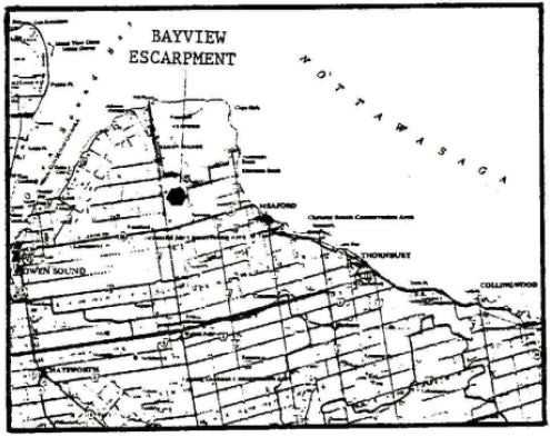
Figure 1: Regional Setting
Targets
1. Life Science Representation (Provincial Significance)
| Site Type/Landscape Unit | Feature |
|---|---|
|
|
2. Earth Science Representation (Regional Significance)
| Geological Theme | Feature |
|---|---|
|
|
3. Cultural Resources Representation
| Theme | Theme Segment |
|---|---|
|
|
4. Recreational Opportunities
| Day Use | Car Camping | Back Coutnry |
|---|---|---|
|
|
|
Inventories
| Level/Type | Earth Science | Life Science | Cultural | Recreational | Other |
|---|---|---|---|---|---|
| Check Sheet | 1977 | 1976 | N/A | N/A | N/A |
| Reconnaissance | Resource Inventory & Analysis,1984 | Resource Inventory & Analysis,1984 | (required) | (required) | Property Management/Operating Plan, 1979 |
| Detailed | N/A | N/A | N/A | N/A | N/A |
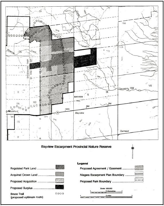
Map: Bayview Escarpment Provincial Nature Reserve
Management Guidelines
I. Land Tenure
A total of 439 hectares is currently regulated under the Provincial Parks Act as part of Bayview Escarpment Provincial Nature Reserve (Ont. Reg. 45/85). Approximately 200 hectares of other acquired provincial lands are located within the proposed park boundary (refer to Figure 2). The park and associated acquired lands are managed by the Ministry of Natural Resources (MNR). The park is located within the Niagara Escarpment Planning Area and is included in the Niagara Escarpment Parks and Open Space System, classed as a Nature Reserve.
Two parcels have agricultural land use permits issued for pasture and/or crop growing: (1) part of the south part of Lot 24, Concession 10, and (2) the south half of the west half of Lot 24, Concession 12, Township of St. Vincent.
A snowmobile trail passing through the park is authorized under a blanket recreational trail land use permit with the Grey Bruce Snowmobile Association.
The nature reserve is bordered on the northeast by the Meaford Tank Range (Department of National Defence).
Guideline:
An annual reassessment will be carried out to determine whether the agricultural and trail land use permits should be renewed. The status of the land use permits will also be reviewed during the park management planning process.
II. Land Acquisition/Disposition
There are approximately 211 hectares of private land and portions of municipal road allowances identified for acquisition within the Niagara Escarpment Planning Area (refer to Figure 2). Acquisition of these lands would consolidate Crown holdings to facilitate management and protection of the significant earth and life science features.
Guidelines:
Acquisition of private lands and municipal road allowances located within the proposed park boundary will be pursued through the Niagara Escarpment Land Acquisition and Stewardship Program and/or through land exchanges.
Circumstances permitting, acquired lands within the proposed park boundary will be regulated under the Provincial Parks Act as part of the provincial nature reserve.
A total of 129 hectares of regulated park property comprising the south part of Lot 24 and Lot 23, Concession 10, Township of St. Vincent, are cleared land partially under agricultural land use permit, but outside the life science Area of Natural and Scientific Interest (ANSI).
The west half of the south half of Lot 24, Concession 12, contains a farm field and grazing area is also under park regulation, but outside the life science ANSI.
Guidelines:
Subject to preparation of a park management plan and an amendment to the Niagara Escarpment Plan, it is proposed that the south part of Lot 24 and Lot 23, Concession 10, may be declared surplus, deregulated and disposed of through sale or land exchange.
The west half of the south half of Lot 24, Concession 12, will be retained and examined at the time of management planning as a potential access point to the park or as surplus land.
III. Existing Development
Existing development is limited to signs demarcating the park boundary and permitted uses, and a snowmobile trail (refer to Figure 1) which passes through the park and acquired provincial lands on an old bush road. The trail is maintained by the Grey Bruce Snowmobile Association under the authority of a recreational trails land use permit.
Guideline:
The status of the snowmobile trail will be reviewed on an annual basis and at the time of park management planning with the intent of phasing this activity out of the nature reserve.
IV. Proposed Development
No development is proposed save for additions or improvements to existing fencing, gates and the posting of the park boundary and permitted uses, as required. The optimum route for the Bruce Trail would pass through the park.
Guidelines:
Further development (excluding those related to public health and safety and resource protection) will not be undertaken prior to completion of a park management plan.
An approval mechanism for development of the optimum route of the Bruce Trail through the park, prior to preparation of a park management plan, will be explored.
V. Recreational Activities
Recreation activities currently permitted in the nature reserve include hiking, cross–country skiing and snowmobiling. All–terrain vehicles and four wheel drive trucks have caused some damage to the area.
Guidelines:
Hiking and cross–country skiing, as a low intensity day–use activities which enhance the appreciation of the park, will be encouraged.
The status of the snowmobile trails will be reviewed during the park management planning process with the intent of eventually phasing it out of the nature reserve.
Fencing, gates and signs, combined with public education and enforcement, will be used as deterrents to unauthorized vehicular access.
VI. Commercial Activities
Guideline:
No commercial activities will be permitted.
VII. Native Interests
There are no known land claims or special treaty rights that have a bearing on park management.
Guideline:
Local native communities will be consulted during the park management planning process.
VIII. Natural Resources
Life Science
Bayview Escarpment Provincial Nature Reserve is part of a provincially significant ANSI which protects a large, diverse, well–preserved example of the Niagara Escarpment slopes, cliffs and plain forests typical of the Grey Section of the escarpment. It contains excellent examples of uncommon Northern Reed Grass–Hairy–fruited Sedge graminoid fen and White Cedar – Red Maple – Yellow Birch mixed swamp communities. Also noteworthy is the representation of rich mixed, broadleaf and conifer talus forests and extensive Mountain Maple talus thickets, Sugar Maple bedrock forests and open cliff communities. The ANSI protects an area with several important ecological functions including groundwater discharge, watershed, natural corridor and forest interior, as well as numerous rare vascular plant species, including several which are new to Grey County.
The preceding summary was derived from a draft of the Bayview Escarpment ANSI Summary prepared by J.V. Jalava in 1994 following site inspection fieldwork completed in 1993 for Bayview Escarpment as part of a future "Ecological Survey of the Niagara Escarpment Biosphere Reserve".
Earth Science
The area has been identified as containing regionally significant earth science features. Some of these features include the exposed contact between Silurian–Ordovician bedrock, crevice caves and examples of mass movement.
Guidelines:
Activities which will negatively impact on life or earth science features will not be permitted.
IX. Cultural Resources
Little is known about the pre–history and history of the park or local area. Numerous groups of native peoples have lived and/or hunted in the Bayview Escarpment area. Land was first surrendered by the First Nations around 1818. The first settlers arrived in the area in the 1820’s, however, St. Vincent Township was not surveyed until 1833.
Guideline:
A reconnaissance level cultural resources inventory and evaluation of the local area may be undertaken prior to preparation of a park management plan.
X. Natural Heritage Education
Existing facilities consist of signs identifying the property as Bayview Escarpment Provincial Nature Reserve. A fact sheet providing basic information about the park is available.
Guidelines:
The fact sheet will be updated and reproduced as required, and made available to the public upon request. The fact sheet must convey the message that visitors have a responsibility to protect the area.
Interpretation will be non–intrusive and rely primarily on the fact sheet and informal personal contacts. The use of the nature reserve by school or other special interest groups must be compatible with the protection needs in this park.
Recreation programs should not be provided.
XI. Research
A life science site inspection was undertaken at Bayview Escarpment in 1993 as part of the "Niagara Escarpment Park/Area of Natural and Scientific Interest Inventory Project". The findings of the field work will be integrated into a summary report, "Ecological Survey of the Niagara Escarpment Biosphere Reserve", expected to be released in 1994/95.
The University of Guelph has, in the past, conducted studies in the area which focused on the form and function of the Niagara Escarpment cliff ecosystem.
The "Resource Inventory and Analysis of the Bayview Escarpment Area" completed in 1984 indicated a need for follow–up studies to determine the overall distribution pattern and the extent of discrete populations within the area for some of the rare species present.
Guideline:
Approved research or inventory projects will be encouraged in accordance with Ontario Provincial Parks policy.
XII. Marketing
There are no plans to promote use of the park apart from general information provided to the public regarding Provincial Nature Reserves and as identified in information presented to the public regarding the Niagara Escarpment Parks and Open Space System.
Guideline:
A marketing plan will not be required.
XIII. References
Cottrill, G. Property Management/Operating Plan for Meaford Recreation Area. Ontario Ministry of Natural Resources, Owen Sound District, Division of Lands, 1979.
Hurford, K.H., Grabs, S.F.E., McLeod, J.R.D. and Whelen, R.L. Resource Inventory and Analysis of the Bayview Escarpment Area. Ontario Ministry of Natural Resources, Owen Sound District, 1984.
Jalava, J.V. Bayview Escarpment Area of Natural and Scientific Interest (ANSI Summary – Ecological Survey of the Niagara Escarpment World Biosphere) Reserve. Ontario Ministry of Natural Resources, 1994.
Niagara Escarpment Commission. The Niagara Escarpment Plan. Ontario Ministry of Environment and Energy, Toronto, 1994.
Ontario Ministry of Natural Resources. Bayview Escarpment Life Science Inventory Checklist. Division of Parks, Toronto, 1976.
Ontario Ministry of Natural Resources. Meaford Lookout Special Area Earth Science Inventory Checklist. Division of Parks, Toronto, 1977.
Ontario Ministry of Natural Resources. Owen Sound District Land Use Guidelines. Owen Sound, 1983.