Beattie Pinery Provincial Park Management Plan
This document provides direction on the management of Beattie Pinery Provincial Park.
Note: This document has been scanned and formatted, and therefore is slightly different from the original version. - June 2002
Additional copies of this publication are obtainable from:
Earl Rowe Provincial Park
P.O. Box 872
Alliston, Ontario L9R 1W1
Telephone:
51204-1
(0.3k P.R., 01 11 09)
ISBN 0-7778-8489-5
Approval Statement
I am pleased to approve the Beattie Pinery Park Management Plan as the official policy for the protection and management of this nature reserve. The plan reflects the Ministry of Natural Resources' and Ontario Parks' commitment to manage the Beattie Pinery for the people of Ontario as a nature reserve, protected from the impacts of human activity, now and in the future.
The plan outlines a prioritized implementation strategy and summarizes the public consultation that occurred as part of the planning process.
The plan for Beattie Pinery Provincial Nature Reserve will be used to guide the management of the park. It may be reviewed to address changing issues or conditions.
I wish to extend my sincere thanks to all those who participated in the public consultation process.
Yours truly,
Adair Ireland-Smith
Managing Director
Ontario Parks
Date: April 22, 2001
Statement of Environmental Values and the Environmental Bill of Rights
In 1994, the Ministry of Natural Resources (OMNR) finalized its Statement of Environmental Values (SEV) under the Environmental Bill of Rights (EBR). The SEV is a document that describes how the purposes of the EBR are to be considered whenever decisions are made in the ministry that might significantly affect the environment. This includes decisions made as a result of the park management planning process.
The primary purpose of the EBR is "to protect, conserve and, where reasonable, restore the integrity of the environment." From the ministry's perspective, that broad statement of purpose translates into four objectives in its SEV:
- to ensure the long-term health of ecosystems by protecting and conserving our valuable soil, aquatic resources, forest and wildlife resources as well as their biological foundations;
- to ensure the continuing availability of natural resources for the long-term benefit of the people of Ontario;
- to protect natural heritage and biological features of provincial significance; and
- to protect human life, the resource base and physical property from the threats of forest fires, floods and erosion.
During the development of the Beattie Pinery Park Management Plan, the ministry considered its SEV. The Management Plan will further the objectives of managing Ontario's resources on an environmentally sustainable basis.
1.0 Introduction
One of the most mature, least disturbed and healthiest White Pine, Red Pine and Sugar Maple upland forests in Ontario south of the Canadian Shield occurs on the Essa Flats within Beattie Pinery Provincial Nature Reserve. The stately trees stand out in sharp contrast to the surrounding open rural landscape normally associated with the production of potatoes. Most of the pine trees in the Beattie Pinery are in excess of 100 years old and are considered, or are approaching consideration as "old growth" forest. The site possesses a great variety of plant species, including one that is both nationally and provincially threatened. The property also provides breeding and foraging habitat for several bird species requiring relatively large tracts of undisturbed forests for survival, such as the Red-eyed Vireo, Ruffed Grouse, Scarlet Tanager and Pileated Woodpecker.
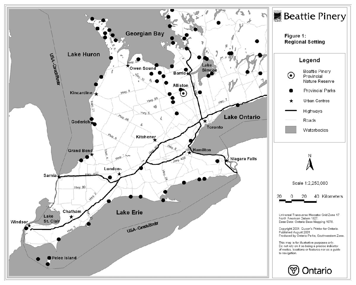
The 68 hectare Beattie Pinery is located three kilometres south of the community of Alliston in the Town of New Tecumseth, County of Simcoe (see Figure 1).
In terms of the property's history, Roland Beattie bought 121 hectares of land, including the 68 hectares of the Pinery, in 1921 from its previous owner John Tackaberry. Mr. Tackaberry had done some cutting in the time that he owned this property, but fortunately the majority of the Pinery remained uncut. Mr. Beattie had planned to build a racetrack on a portion of the land that had been previously cut and cleared within the Pinery. He passed away before being able to complete the project. That portion of cleared land (7.3 hectares) was used for farming ever since Roland Beattie's death in 1926. Some tree harvesting occurred in the early 1950's when one to two hundred Red Pine were selectively cut and used in the construction of the Burlington Skyway. The Pinery has been owned by and passed down through the Beattie family since 1921.
The Nature Conservancy of Canada (NCC) secured this property on July 27, 1995 from its previous owner, MacKenzie Beattie Limited. The transaction included a very generous donation from the Beattie family members associated with MacKenzie Beattie Limited. The secured lands include the north half of Lot 2, Concession 12, and the part of the north half of Lot 3, Concession 12, (within the geographic Township of New Tecumseth) that lie west of the Canadian Pacific Railway (CPR).
The OMNR, through Ontario Parks, and the NCC have been working together to secure significant natural areas in this province for many years. In April 1996, OMNR and The Conservancy solidified this partnership as a multi-year agreement called the Ontario Parks Legacy 2000 program.
Under this program, Ontario Parks provided venture capital to The Conservancy to help secure new park land by the year 2000. Beattie Pinery Provincial Nature Reserve is one of those new parks.
Figure 1. Regional Setting.

Enlarge Figure 1. Regional Setting
Ontario Parks agreed to lease the property from the NCC for its long term management as the Beattie Pinery Provincial Nature Reserve. The area was regulated under the Provincial Parks Act in 1997 (Ontario Regulation 257/97). This Nature Reserve makes a significant contribution to the Provincial Parks system. Other provincial parks within the area include Earl Rowe, Mono Cliffs, Boyne Valley and Hockley Valley.
A Beattie Pinery Provincial Nature Reserve Interim Management Statement was approved in December 1997 to provide interim direction for the custodial management of the property until this plan was approved.
Beattie Pinery is situated on the Nottawasaga River and lies within the jurisdiction of the Nottawasaga Valley Conservation Authority. Adjacent land uses include agriculture, rural residential and commercial transportation.
2.0 Classification
All provincial parks in Ontario fall into one of six classes: wilderness, nature reserve, historical, natural environment, waterway and recreation. Beattie Pinery is classed as a Provincial Nature Reserve.
Nature Reserves are areas selected to represent the distinctive natural habitats and landforms of the province. They are protected for educational purposes, as gene pools for research to benefit present and future generations and for their intrinsic values to society.
Beattie Pinery offers excellent representation of sand plain communities on the Simcoe Lowlands, notably the White and Red Pine forest which can be considered rare to uncommon in southern Ontario.
3.0 Goal
The goal for Beattie Pinery Provincial Nature Reserve is to preserve the park's environment, which contains provincially significant biological features.
Beattie Pinery Provincial Nature Reserve will be managed for the people of Ontario as an area of nature reserve, protected from the impacts of human activity, now and in the future. The park is governed by the Ontario Provincial Parks Act, the Ontario Provincial Parks Policy and Ontario Provincial Parks: Planning and Management Policies (1992).
4.0 Objectives
There are four established objectives for the Ontario Provincial Parks system: protection, recreation, heritage appreciation and tourism. As a Provincial Nature Reserve, Beattie Pinery contributes primarily to the protection and heritage appreciation objectives.
4.1 Protection Objective
The Nature Reserve's protection objective is to protect provincially significant, special and representative life science features.
The protection objective will be accomplished through appropriate zoning, land use controls, research, monitoring and a greater park ecosystem approach to park planning and management. The greater park ecosystem can be defined as the area of influence surrounding Beattie Pinery from an ecological, social and economic point of view. It is also the area where most of the impacts affecting the park occur. Beattie Pinery has its own, unique greater park ecosystem, based on the specific objectives that the park has been established to protect. A number of variables including vegetation, watershed, geology, habitat, recreation, tourism and development can be used to define the greater park ecosystem. The ecosystem management approach is a co-operative and participatory one. It does not imply provincial control in local affairs or place any restrictions on private property rights.
Adjacent private lands may be secured to consolidate and protect additional natural values associated with the Alliston Pinery Life Science Area of Natural and Scientific Interest (ANSI).
4.1.1 Life Science
The Beattie Pinery (located in ecological Site District 6-6) has been identified as part of the provincially significant Alliston Pinery Life Science Area of Natural and Scientific Interest. One of the most mature, least disturbed, and healthiest White Pine, Red Pine, and Sugar Maple upland forests on the Essa Flats lies within the Pinery. Most of the pine trees in the forest are in excess of 100 years old and are considered, or are approaching consideration as "old growth" forest by Ministry of Natural Resources' standards. The White Pine forest in this area is considered rare to uncommon in Ontario south of the Canadian Shield.
The Beattie Pinery has 289 vascular plant species including a nationally and provincially threatened plant species, a regionally rare Clear- Weed, and a locally rare sedge. There is a wide diversity of birds with 68 different species, 46 of which are breeding species. Eleven species of these breeding birds have experienced some population decline. These include species such as Ruffed Grouse, Scarlet Tanager, Pileated Woodpecker, and Red-eyed Vireo. These species require large tracts of undisturbed interior forests for breeding and nesting. The Nottawasaga River valley which passes through the Beattie Pinery serves as an important corridor for migration and natural range expansion of many plant and animal species.
4.1.2 Earth Science
The site lies within the Nottawasaga Basin, the watershed for the Nottawasaga River. The Essa Flats within the Basin are covered in a fine sandy loam deposited by the glacial lake, Lake Algonquin. This material is mildly acidic with an abundance of lime in its parent material, good drainage and a fair moisture holding capacity. These are the soils which give the Alliston vicinity their reputation for potato growing (Chapman and Putnam, 1973). Underlying the surface material are glacial and outwash tills which are in turn underlain by Ordovician shales and limestones. The Nottawasaga River meanders through the Beattie Pinery, adding to the diversity of the site.
4.2 Heritage Appreciation Objective
The Nature Reserve's second heritage appreciation objective is to provide opportunities for exploration and appreciation of natural environments through interpretation and education based upon the character and significance of the Beattie Pinery.
Individual exploration and appreciation will be encouraged, where compatible with, and complementary to, protection of life and earth science features. Development of a self-guided interpretive trail will assist individuals in exploring and appreciating the Nature Reserve.
The Nature Reserve's second heritage appreciation objective is to provide opportunities for exploration and appreciation of natural environments through interpretation and education based upon the character and significance of the Beattie Pinery.
Interpretive and educational programmes will be developed, compatible with and complementary to protection of life and earth science features. Visitors to the Nature Reserve will gain an appreciation for the significance and protection of the natural values on site through the use of interpretive panels and a leaflet.
5.0 Boundary
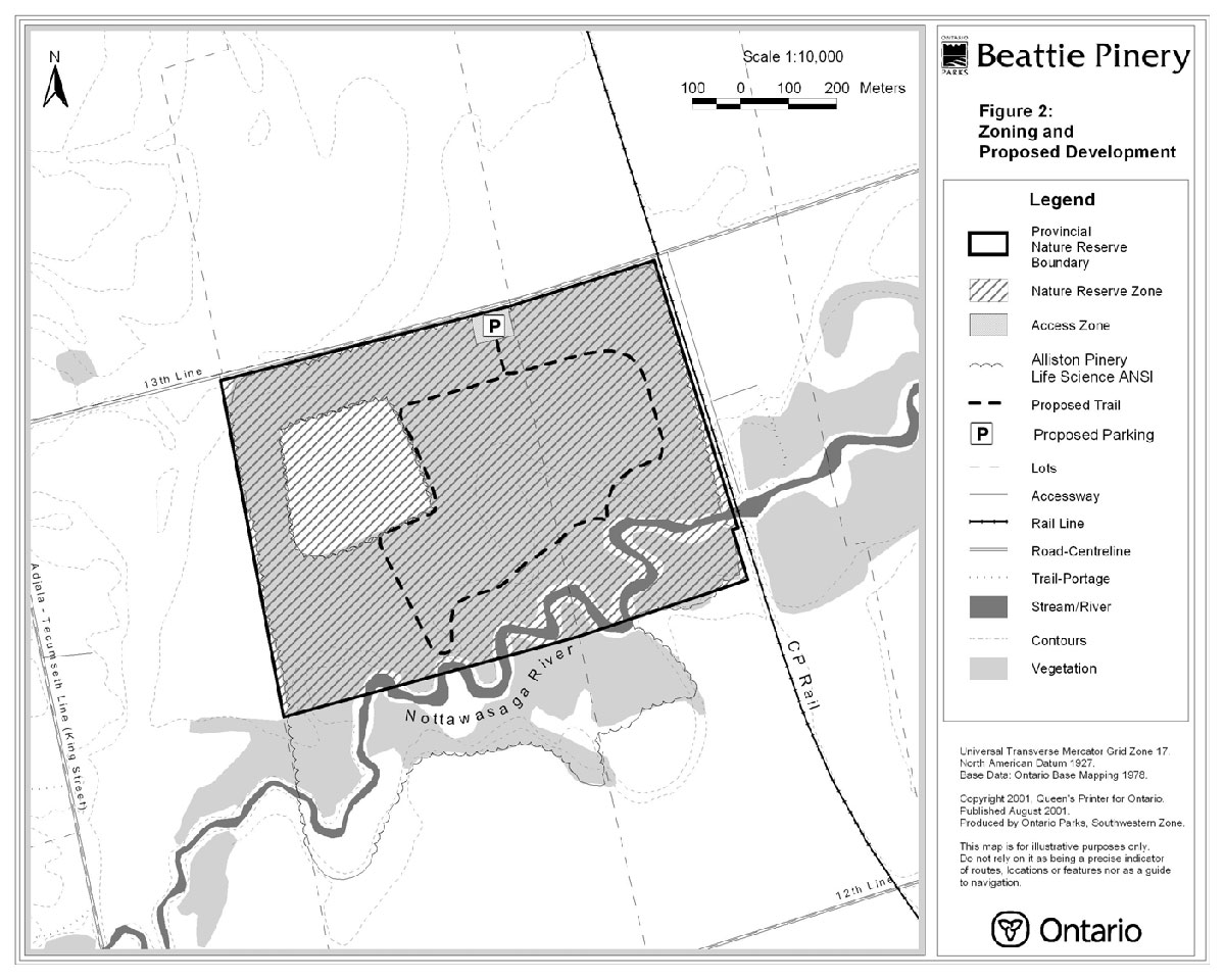
The Provincial Nature Reserve boundary is shown in Figure 2. Beattie Pinery is bounded by a travelled municipal road, the 13 Line (north), the Canadian Pacific Railway (east) and private property (south and west). The boundary will be posted and, should the need arise, fencing and gating may be installed where required to restrict access.
Additional portions of the Life Science ANSI are located on private lands in the south halves of Lots 2 and 3, Concession 12, within the geographic Township of New Tecumseth. These adjacent ANSI lands are traversed by the Nottawasaga River valley and primarily contain mixed/coniferous bottomland forests, deciduous bottomland forests and open fields. The locally rare Riverbank Wild Rye has been identified in this area.
Certain adjacent private lands may be secured to protect and buffer significant natural features and resources, subject to the availability of funding and the willingness of landowners to sell.
6.0 Zoning
Lands and waters contained within Beattie Pinery Provincial Nature Reserve are zoned in accordance with their environmental qualities and required protection. The two zoning categories designated for the Beattie Pinery Provincial Nature Reserve (nature reserve zone and access zone) are based on the Ontario Provincial Parks: Planning and Management Policies. The zones differentiate the degree of development, uses and management practices permitted in each (see Figure 2).
6.1 Nature Reserve Zone
This 67.5 hectare zone includes the significant life science features of the Nature Reserve, as well as a protective buffer, in which there is an absolute minimum of development. Development will be restricted to a self-guided interpretive trail, for walking and snowshoeing, with interpretive panels.
Agricultural use on the 7.3 hectares of open field will be considered an existing, non-conforming activity to be phased out following expiration of the agricultural lease. As soon as it is retired, this area will be restored.
6.2 Access Zone
Adjacent to the 13th Concession is a 0.5 hectare plot which will serve as a staging area where minimal facilities will support public use of the Nature Reserve zone. The small staging area will provide parking for a maximum of six vehicles, washroom, an entrance sign and a small interpretive kiosk with a plaque recognizing the contributions of the Beattie family, the former owners of the property.
7.0 Natural Heritage Stewardship Policies
Beattie Pinery Provincial Nature Reserve will be managed in accordance with the policies set out in the Ontario Provincial Parks: Planning and Management Policies.
Acknowledged is the involvement of Beattie family members living nearby who have served as volunteer property stewards on behalf of The Nature Conservancy of Canada. The property will be monitored against vandalism, unauthorized use, fires, et cetera.
A local management advisory committee may be consulted on proposed major resource management activities (e.g. planting trees, removing exotic plant species, etc.) in the Nature Reserve (refer to Section 10.0). Resource management initiatives may be accomplished through partnerships and sponsorships.
7.1 Landform and Water
The following landform and water stewardship policies may be addressed in greater detail in a subsidiary natural heritage stewardship strategy, as required.
Ontario Parks will not support any proposal by the Canadian Pacific Railway to widen the right- of-way adjacent to the Beattie Pinery.
Waters in the abutting portion of the Nottawasaga River will not be controlled except to perpetuate natural features and conditions where desirable. Stream bank erosion along the river may be monitored periodically. Riparian revegetation measures may be considered to prevent or mitigate erosion. Except for specific interpretive locations, a nature trail will be sited well back from the stream bank.
The effects of local agricultural irrigation on the Beattie Pinery are not known. This may be a topic of future research.
7.2 Vegetation
The following vegetation stewardship policies may be addressed in greater detail in a subsidiary natural heritage stewardship strategy, as required.
No commercial harvesting of timber will be permitted. Except where there is threat to public safety, dead trees will be left standing to serve as important homes for resident cavity nesting birds and mammals such as the Northern Flying Squirrel, Hairy Woodpecker and Pileated Woodpecker. Dead tree falls and tip-ups will also be left in place to serve as important sites for mosses and fungi, germination areas for tree species requiring rotting wood as a rooting medium, and moist shelters for small mammals, reptiles, amphibians and a variety of insects.
Figure 2. Zoning and Proposed Development

Enlarge Figure 2. Zoning and Proposed Development
Former agricultural areas in the Nature Reserve will be restored to complement the adjacent forest cover. Vegetation restoration and recovery efforts will be monitored (e.g., aerial and/or ground level photographs may be taken on a regular basis).
Canadian Pacific will be encouraged to use only mechanical means to remove brush from the adjacent portion of railway right-of-way.
Confined herbicidal spraying of poison ivy within the Nature Reserve may occur along the trail or parking area.
Without severe fire disturbance to pine stands, such forests usually change over time into more mesic maple-dominated forests. However, such disturbances are unlikely to ever occur again on the sand plains of the Essa Flats. Therefore, natural pine forests will continue to be extremely rare. Because of this rarity, and because of the scientific and educational values of the Beattie Pinery, consideration will be given to perpetuating a pine forest on the site through application of prescribed burning.
Prescribed burning may be addressed in a natural heritage stewardship plan. In the interim, forest fires due to natural or other causes will be suppressed by the local municipal fire department.
Vegetation management targets will include:
- protective management of vulnerable, threatened or endangered species;
- the provision of opportunities for viewing and interpreting plants;
- perpetuating an old growth pine forest;
- increasing the amount of interior forest through restoration of the open field;
- control of alien flora, insects and herbivores;
- the protection of plant communities from adverse impacts such as trampling and picking;
- riverbank stabilization;
- improved shading along river to enhance coldwater fish habitat;
- control of Poison Ivy adjacent to trail and parking area.
Vegetation management prescriptions may be identified in a more detailed natural heritage stewardship plan.
7.3 Wildlife
Sport hunting and commercial trapping will not be permitted in the Beattie Pinery. However, control of particular species may be required for public safety, protection of property, and perpetuation of natural values.
The Nottawasaga River is a cool water stream containing resident Brown Trout and providing migratory and spawning habitat for Rainbow Trout and Chinook Salmon. Sport fishing will not be permitted in the Nature Reserve and upon further review, a fish sanctuary may be established.
Fisheries and wildlife management will be directed to the maintenance of an evolving natural ecosystem, unless alternative strategies are desirable. Adaptive management strategies may be addressed in a natural heritage stewardship plan.
8.0 Operations Policies
Operations policies for Beattie Pinery will be incorporated into the operations plan for Earl Rowe Provincial Park. The revised plan will provide park staff and partners with the necessary direction to effectively manage the Nature Reserve. In addition to addressing the operations policies that follow, the plan will include such topics as budget, staffing, maintenance schedules, enforcement and emergency services. Wherever possible, the provisions of the plan will be consistent with the approved Ontario Provincial Parks Minimum Operating Standards and will be reviewed annually and updated as required.
Ontario Parks' staff will report noteworthy occurrences (e.g., incidents, infractions, etc.) in the Nature Reserve to a designated representative of The Nature Conservancy of Canada.
8.1 Natural Heritage Education
Services for visitors, including school groups, will be primarily oriented towards self-guided use. The three components of the natural heritage education program are information, interpretation and recreation.
8.1.1 Information
Objectives for the information component of the natural heritage education program include:
- inform visitors about the Nature Reserve, its features, facilities and management;
- instil in visitors a sense of respect for the park environment;
- describe the role of Ontario Parks and the Ministry of Natural Resources;
- describe the role of The Nature Conservancy of Canada and the Legacy 2000 program;
- provide a means for the visitor and stakeholders to communicate with Ontario Parks regarding park management.
The preceding objectives may be achieved through a combination of a park leaflet (trail guide), interpretive panels, media, informal meetings with a management advisory committee and stakeholders, and personal contacts with park visitors.
8.1.2 Interpretation
Beattie Pinery contains several significant and interesting natural features worthy of interpretation. Natural heritage education facilities and services will be very limited in scope, focusing on a self-guided interpretive trail in conjunction with interpretive panels and an information leaflet.
8.1.3 Recreation
Walking and snowshoeing will occur on a self- guided interpretive trail. Some canoeing may occur by virtue of the fact that the Nottawasaga River flows through the Nature Reserve. Recreation programming will not be offered.
8.2 Research
Scientific research by qualified individuals contributing to the knowledge of natural and cultural history and to environmental management will be encouraged. All research projects will require the approval of Ontario Parks and must meet all requirements under applicable provincial and federal legislation. Approved research activities must be consistent with Ontario Parks' Research and Information Strategy.
A biological inventory and evaluation was completed for the Alliston Pinery Life Science Area of Natural and Scientific Interest in 1992. Future research might include, but not necessarily be limited to:
- aquatic inventory and evaluation of the Nottawasaga River;
- insect inventory;
- reptile and amphibian inventory;
- reconnaissance archaeological inventory;
- monitoring regeneration in the interior farm field following initiation of restoration efforts;
- studying natural successional changes (e.g., trend towards maples);
- studying ecological processes ongoing in old-growth pine forests;
- study of the impacts of farm irrigation on vegetation communities;
- comparison of agricultural production of interior field to open field.
8.3 Recreation Management
Low intensity recreational use will be confined to walking and snowshoeing on a designated self- guided interpretive trail. Canoeing may occur as this section of the Nottawasaga River is deemed navigable during certain times of the year.
Prohibited activities in the Nature Reserve include camping, sport hunting, angling and horseback riding. Aside from agricultural vehicles permitted during the term of the lease agreement, vehicles (including bicycles) will not be permitted within the nature reserve zone.
9.0 Development Policies
The following is a low-impact, ecologically sustainable development concept for Beattie Pinery Provincial Nature Reserve (see Figure 2). More detailed site and development concepts will be prepared prior to implementation.
9.1 Access
Public access to the Beattie Pinery will be provided through a single entrance off the 13th Concession, west of the CPR right-of-way, at the site of an existing steel gate. Development may include parking for a maximum of six vehicles, washroom, entrance sign, interpretive kiosk, plaque and trailhead. Boundary signs, fencing and gates may be installed as required to prevent unauthorized access.
9.2 Trail
A low-impact self-guided interpretive trail may be developed for use by walkers and snowshoers. The trail will start and return in the immediate vicinity of the proposed parking area. Except for a specific interpretive location(s), a nature trail will be sited well back from the Nottawasaga River. A viewing platform may be constructed to reduce impacts on the stream bank and to maintain visitor safety. Where possible, trail alignment will follow old bush trails.
9.3 Interpretive Facilities
Interpretive facilities will be modest, consisting of a kiosk at the trailhead and additional panels at key locations along the nature trail.
10.0 Implementation Policies
In the implementation of the approved Park Management Plan, Ontario Parks will consult with The Nature Conservancy of Canada. An informal Beattie Pinery Provincial Nature Reserve Management advisory committee may meet as required to discuss matters pertaining to the property. Opportunities for partnerships involving volunteers, school boards, non- government organizations or others will be explored.
Implementation of the Management Plan shall occur in an ecologically sustainable manner. All the requirements of the Environmental Assessment Act, Environmental Bill of Rights, Provincial Parks Act and other pertinent legislation will be met. Implementation and/or site plans will precede any development or resource management initiatives, with an appropriate level of public consultation. Development projects and preparation of implementation plans will be contingent upon the availability of funding and unforeseeable changes in priorities or park policy.
Implementation priorities include:
- development of a self-guided interpretive trail;
- restoration of interior field following cessation of agricultural use;
- installation of an entrance sign and boundary markers;
- installation of fencing and gates as required;
- installation of interpretive panels and a plaque;
- preparation of an interpretive and information leaflet;
- development of a parking lot and washroom.
In accordance with the lease agreement between Ontario Parks and The Nature Conservancy of Canada, Ontario Parks shall provide the NCC with an annual report on the Beattie Pinery Provincial Nature Reserve.
11.0 Summary of Public Consultation
Public consultation was a very important part of the park management planning process. The four phases of the process consisted of:
- Phase 1 - Terms of Reference
- Phase 2 - Background Information
- Phase 3 - Preliminary Management Plan
- Phase 4 - Approved Park Management Plan
Phase 1 consisted of a 45 day public opportunity to inspect the approved Terms of Reference for the management planning process in the summer/early fall of 1998. An initial invitation to participate was mailed out to 63 local residents and stakeholders announcing the upcoming public consultation and planning process and a public notice was posted on site. In addition, a policy proposal file was posted on the Environmental Bill of Rights (EBR) Environmental Registry.
Phase 2 focused on providing an opportunity for interested groups and individuals to review relevant background information. During the fall of 1998, a 45 day opportunity for the public to review this information was made available at the Earl Rowe Provincial Park office. To initiate the 45 day review period, a notice was mailed to 63 local residents and stakeholders.
Phase 3 included the preparation, approval and publication of the Beattie Pinery Provincial Nature Reserve Preliminary Management Plan during the spring of 1999. Copies of the document were mailed directly to 69 stakeholders, adjacent property owners and other interested individuals. A paid advertisement was placed in local newspapers to invite written comments. An open house was held at the Dufferin County Museum on March 20, 1999, with an attendance of approximately 20 people. A planning update was mailed out in April 1999 to provide a "snapshot" of the comments received during the open house. An updated policy proposal file was posted on the Environmental Bill of Rights Environmental Registry.
As part of Phase 4, all public comments were fully considered in the preparation of the final Management Plan. Changes to the final document included:
- Zoning of the agricultural land as Nature Reserve and current agricultural practices deemed to be an existing non-conforming use.
- Additional emphasis placed on the monitoring and protection of riparian zone erosion.
Phase 4 culminated with the release of the approved Beattie Pinery Park Management Plan in February 2001. Copies of the document were distributed to 76 groups or individuals. A paid advertisement was placed in local newspapers and a policy decision notice was also posted on the EBR Environmental Registry.
The public was given a final opportunity to review the approved Management Plan for a period of forty-five (45) days after its formal release. This allowed interested participants in the planning program a final opportunity to determine if their concerns had been considered and addressed and to initiate an appeal concerning the plan contents where appropriate.
The Management Plan for Beattie Pinery Provincial Nature Reserve may be reviewed or amended to address changing issues or conditions. A review may involve a reassessment of all or part of the plan, including classification, zoning, goal, objectives and all resource management, operations and development policies, while an amendment may be considered to address specific issues or needs.
Ontario Parks will retain on file reference copies of relevant background information, Terms of Reference, Preliminary Management Plan, approved Park Management Plan, and any subsequent plan reviews or amendments.
12.0 References
Anderson, Allan and Tomlinson-Anderson, Betty (Editors). Tecumseth Township. The Unforgettable Past. The Corporation of the Township of Tecumseth, 1984.
Chapman, L.J. and Putnam, D.F. The Physiography of Southern Ontario. 2nd Edition, Ontario Research Foundation, Toronto, 1973.
Drysdale, Douglas. A Study of the Forest Industry in Simcoe County and the Factors Relating to its Present and Future Importance in that Economy. The University of Toronto, 1957.
Hunter, Andrew F. A History of Simcoe County. The Historical Committee of Simcoe County, 1948.
Ontario Ministry of Natural Resources. Beattie Pinery Provincial Nature Reserve Interim Management Statement. Southwestern Parks Zone, Ontario Parks, London, 1997.
Ontario Ministry of Natural Resources. Beattie Pinery Provincial Nature Reserve Preliminary Management Plan. Southwestern Zone, Ontario Parks, London, 1999.
Ontario Ministry of Natural Resources. Beyond 2000 – Ministry of Natural Resources Strategic Directions. Natural Resources Information Centre, Peterborough, 2000.
Ontario Ministry of Natural Resources. Environmental Assessment in Ontario Provincial Parks: An Interim Field Reference for Staff, Revised Edition. Corporate Policy and Planning Secretariat, 1994.
Ontario Ministry of Natural Resources. Environmental Bill of Rights Procedures Manual (Working Draft). Corporate Policy and Planning Secretariat, 1995.
Ontario Ministry of Natural Resources. Huronia District Land Use Guidelines. Midhurst, 1983.
Ontario Ministry of Natural Resources. Ontario Provincial Parks Management Planning Manual. Provincial Operations Branch, Peterborough, 1994.
Ontario Ministry of Natural Resources. Ontario Provincial Parks: Planning and Management Policies. Parks and Recreational Areas Branch, Toronto, 1978.
Ontario Ministry of Natural Resources. Ontario Provincial Parks: Planning and Management Policies, 1992 Update. Provincial Parks and Natural Heritage Policy Branch, Toronto, 1992.
Ontario Ministry of Natural Resources. Provincial Parks Act, Revised Statutes of Ontario, 1990.
Varga, Steve and Schmelefske, John. Biological Inventory and Evaluation of the Alliston Pinery Area of Natural and Scientific Interest. Ontario Ministry of Natural Resources, Southern Region, Aurora, 1992.