Big Spring Lake Bedrock Conservation Reserve Management Statement
This document provides policy direction for the protection, development and management of the Big Spring Lake Bedrock Conservation Reserve and its resources.
November 2002
Kirkland Lake District
Ministry of Natural Resources
1.0 Introduction
Ontario’s network of natural heritage areas has been established to protect and conserve areas representative of the diversity of the natural regions of the province, including species, habitats, features and ecological systems which comprise that natural diversity. Protected natural heritage areas are a key component in sustainable management of natural resources. They ensure that representative sites within the larger sustainably managed landscape are permanently retained in their natural state.
Natural heritage areas are considered to be sensitive, requiring protection from incompatible activities if their values are to endure over time. The Ministry of Natural Resources has established conservation reserves as a new tool to offer protection for these areas on public lands, while permitting many traditional public uses to continue. Such uses include the traditional activities of Aboriginal peoples.
Ontario’s Living Legacy Land Use Strategy (OLL LUS MNR, 1999) sets the direction for the administration and management of parks and protected areas on Crown lands within three planning regions including; the Boreal West, Boreal East and Great Lakes- St. Lawrence areas. This strategy’s natural heritage objectives include protection of natural and cultural heritage values and the provision of opportunities for outdoor recreation, heritage appreciation and tourism (MNR, 1999).
Protected areas designated within the OLL LUS have been selected based on their representation of the spectrum of the province’s ecosystems and natural features including both biological and geological features, while minimizing impacts on other land uses. Representation was described using landform and vegetation combinations based on Hill’s (1959) site district concept. For the Big Spring Lake Bedrock Conservation Reserve (C1617), the dominant landform vegetation type represented here is weakly broken bedrock with mixed deciduous forest. Other vegetation types include sparse forest, mixed coniferous forests, dense deciduous forest as well as some wetlands.
The Big Spring Lake Bedrock Conservation Reserve is located approximately 23 km southeast of the town of Elk Lake, Ontario south of Highway 65 (See Location Map, Appendix 7). The conservation reserve, which is situated within the OLL Boreal East Planning Region, has an area of 973 ha. and is located within the Townships of Barber and Cane. These two townships are situated in the Kirkland Lake District within the MNR’s Northeast Region. The site itself is bordered by Big Spring Lake to the east and the Montreal River runs through the middle of it. The conservation reserve will be managed under a Statement of Conservation Interest (SCI).
Statement of Conservation Interest (SCI) documents are the minimum level of management direction established for any conservation reserve and generally are brief management plans. This SCI will govern the lands and waters within the regulated boundary of the Big Spring Lake Bedrock Conservation Reserve. However, to ensure MNR protection objectives are being fully met within this conservation reserve, the surrounding landscape and related activities should consider the site’s objectives and heritage values. In addition, it is the intent of this SCI to create public awareness that will promote responsible stewardship of protected areas and surrounding lands. With management partners such as Ontario Parks, industry, and local governments. MNR District staff will be able to pursue and advance sound environmental, economic and social strategies and policies related to the protection of conservation reserves and provincial parks.
The purpose of this SCI is to identify and describe the values of the Big Spring Lake Bedrock Conservation Reserve and outline the Ministry’s management intent for the conservation reserve. The management direction will protect the site’s natural heritage values and demonstrate its compatibility within the larger sustainable landscape. This direction will comply with land use intent as stated by the OLL Land Use Strategy (MNR, 1999).
2.0 Goals and Objectives
2.1 Goals of Statement of Conservation Interest
The goal of this SCI is to describe and protect natural heritage values on public lands while permitting compatible land use strategies.
2.2 Objectives of SCI
2.2.1 Short Term Objectives
To identify the State of the Resource with respect to natural heritage values and current land use activities for the Big Spring Lake Bedrock Conservation Reserve. A priority will be placed on the protection of the site’s natural values via specific guidelines, strategies and prescriptions detailed in this plan. Finally legislated planning requirements will be met (e.g. SCI development within three years of regulation).
2.2.2 Long Term Objectives
The long-term objectives will be to establish representative targets (e.g. future forest conditions) and validate the site as a potential scientific benchmark. To ensure protection of natural and cultural heritage features and values, this SCI will establish an evaluation process to address future new uses and commercial activities associated with them (e.g. Test of Compatibility Procedural Guideline B in Conservation Reserve policy PL 3.03.05). Finally, this SCI will identify research/client services and marketing strategies.
3.0 Management Planning
3.1 Planning Area
The planning area for this SCI will consist of the regulated boundary for the Big Spring Lake Bedrock Conservation Reserve (See Locator Map, Appendix 7).
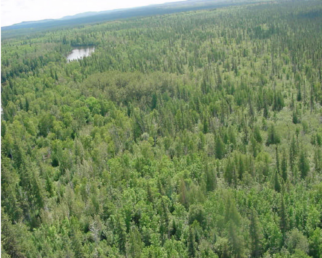
Figure 1.0 View looking southeast over Big Spring Lake. The left hand shoreline is part of the boundary for C1617. Photo taken in November, 2000, by Craig Fuller.
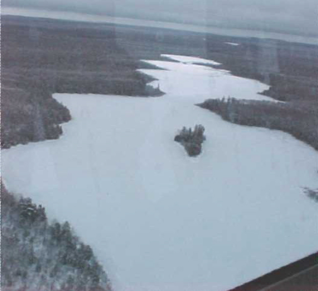
Enlarge Figure 1.0 View looking southeast over Big Spring Lake.
The plan will recognize the protection of values within the planning area; however, to fully protect values within the conservation reserve, the lands beyond the regulated body may require additional consideration within larger land use or resource management plans.
3.2 Management Planning Context
The Big Spring Lake Bedrock Conservation Reserve was first designated as a candidate conservation reserve by MNR in the OLL Proposed Land Use Strategy (MNR, March 1999) and ultimately as a conservation reserve in the final OLL Land Use Strategy (MNR, 1999). The site was regulated under an amendment of Ontario regulation 805/94 made under the Public Lands Act on April 6, 2001. Management and planning direction for this site will follow the OLL LUS (MNR, 1999) and this management statement. The area encompassed by this site has also been removed from the Timiskaming Forest Alliance Inc. Sustainable Forest License (SFL) landbase.
By regulation this conservation reserve cannot be used for commercial forest harvest and hydroelectric power development. Currently no mining tenure exists within the site and the site has been withdrawn from staking under the Mining Act. Existing recreational activities within this reserve will continue to be permitted, therefore such activities as sport hunting and fishing are permitted to continue. This SCI document and future management of the site will continue to resolve conflicts regarding incompatibility between uses and to ensure that identified values are adequately protected.
This Statement of Conservation Interest will only address known issues or current proposals with respect to permitted uses or potential economic opportunities brought forward to the District Manager during this planning stage. However, in terms of approving future permitted uses and/or development(s), there are established mechanisms in place to address such proposals. Any future proposals will be reviewed using the Procedural Guideline B – Land Uses – Test of Compatibility Public Lands Act Policy PL 3.03.05 (MNR, 1997) or other standard MNR environmental screening processes.
Consideration of proposals pertaining to cultural resources may be screened through Conserving a Future for our Past: Archaeology, Land Use Planning & Development in Ontario, Section 3 (MCzCR, 1997) and MNR’s history in establishing AOC descriptions and prescriptions for cultural heritage resources within forest management plans (FMPs).
These planning tools will help refine the review process once the proposal satisfies the direction and intent of the Public Lands Act, associated policies and this planning document.
3.3 Planning Process
Once a conservation reserve is passed into regulation, it must be determined what level of management planning is required to fulfill the protection targets. There are two policy documents involved. A Statement of Conservation Interest (SCI) is the minimal requirement for providing planning direction; a Resource Management Plan (RMP) deals with more complex issues where several conflicting demands are placed on the resources. The guidelines fo r the preparation of these documents are outlined in Procedural Guideline A – Resource Management Planning (Conservation Reserves Procedure PL 3.03.05 Public Lands Act). The appropriate plan must be completed within three years of the Conservation Reserve’s regulation date.
For current planning purposes, the Big Spring Lake Bedrock Conservation Reserve will be managed under the auspices of a Statement of Conservation Interest. Interested parties from both the private and public sectors were consulted during the OLL implementation process, from candidate conservation reserve to regulation. The intent of this SCI is to fulfil the commitments made within the OLL LUS (MNR, 1999). In addition, a public notification and review of a draft of this SCI document occurred for a period of 30 days during August/September 2002. During this period, the MNR received no new permitted use or development proposals for this conservation reserve. Therefore, no new decisions have been identified by the MNR since the implementation of the OLL strategy.
The revised SCI was reviewed by the Kirkland Lake District Manager (DM). Upon approval by the DM the SCI was presented to the Northeast Regional Director (RD) for final approval.
Following RD approval, interested public, user groups and industry were notified that the Statement of Conservation Interest for the Big Spring Lake Bedrock Conservation Reserve was approved.
Public consultation will be solicited during a review of any future land use proposals that would require ne w decisions to be made. In addition, any future proposal and/or any new, significant management direction considered will be published on the Environmental Bill of Rights Registry (EBR).
The SCI is a planning document that will provide background information, identify values to be protected and establish management guidelines for use in the administration of the conservation reserve.
The implementation of the SCI will be the mandate of the MNR at the district level, however associations with various partners may be sought to assist in the delivery. This SCI is a working document; therefore it may be necessary to make revisions to it from time to time.
4.0 Background Information
4.1 Location and Site Description
4.1.1 Location
The following table describes the location and provides administrative details of the site:
Table 1: Location Data
| Name | Big Spring Lake Bedrock Conservation Reserve |
|---|---|
| Site Region – Site District (Hills) | Temagami Site District 4E-4 |
| MNR Administrative Region/District/Area | Northeast Region/Kirkland Lake District in the Kirkland/Claybelt Area |
| UTM Ref. | 639 713 |
| Nearest Town/Municipality | Southeast of Elk Lake and the Municipality of James |
| Township(s) | Townships of Barber and Cane |
| OBM Numbers | 17 5600 52700 / 17 5600 52600 |
| Topographical Map Name/Number | Elk Lake 41 P/9 |
| Wildlife Management Unit | 28 and 40 |
| Forest Unit | Timiskaming Forest |
4.1.2 Site Description
4.1.2.1 Physical Description
Big Spring Lake Bedrock Conservation Reserve is a 973 ha parcel of Crown land that is situated south of Highway 65 and approximately 23 km southeast of the town of Elk Lake. The Montreal River which runs north south through the reserve provides a major water route. The border on the southwest side of the site is the north shore of Big Spring Lake. The Montreal River and a small creek associated with Big Spring Lake join forming a junction of these two water bodies just south of the site’s southern boundary.
The Conservation Reserve is located in Hill’s (1959) Site District 4E-4 which is characterized by a rolling plain of rock-knob uplands, shallowly covered with stony silty sand, broken by occasional trains of sorted coarse and medium sand (gravelly in places). Bedrock is dominantly low base and frequently moderately resistant to weathering. The materials are a mixture of low base and granitic (Poser 1992).
Big Spring Lake Bedrock Conservation Reserve is located within the Northern Clay forest region, which occupies the central portion of the gently northward sloping Laurentian plateau in Quebec and Ontario. The forest of this section is conditioned by widespread surface deposits of water-worked tills and lacustrine materials, and by a nearly level topography – inheritance from glacial lake Ojibway.
4.2 Administrative Description
The legal boundaries of the Big Spring Lake Bedrock Conservation Reserve were filed on January 11, 2001 in the Office of the Surveyor General, Ministry of Natural Resources in Peterborough, Ontario. The site was regulated on April 6, 2001 (O. Reg. 86/01). The conservation reserve is located within the Timiskaming Forest.
4.3 History of Site
The Montreal River that flows through the site has long been used as a canoe route which flows into the Ottawa River system. It was first used as a traditional route by many of the aboriginal communities in the area for trading, gathering and migration patterns. More recently this route is used by canoeists for extended trips which can range from days to weeks.
The Big Spring Lake Bedrock Conservation Reserve also contains parts of 4 fur harvest traplines as well as 3 bear management areas. Timber harvesting has also taken place in close proximity to the site, including one block that was harvested in 2001 along the northwest boundary of the site. Up until recently, access to the area has been limited to a few trails, the Montreal River, or aircraft. This has allowed the area to remain pristine, with a majority of the forested lands untouched, as evidenced by the number of old growth stands in the site.
Also located within the site boundaries, towards the south along the Montreal River is a trap cabin, which still seems to be in use. Also in close proximity to the site on Big Spring Lake and the Montreal River are summer recreational camps. The camps located on Big Spring Lake are water access, possibly using the trail north of the lake for part of the journey. The camp located on the Montreal River; however, has a trail from the north that runs right up to the cabin.
4.4 Inventories
The following table indicates the current status of natural heritage inventory that has occurred or is required in the near future:
Table 2: Inventory Data
| Survey Level | Earth Science | Life Science | Cultural | Recreational | Other |
|---|---|---|---|---|---|
| Reconnaissance | August 2001 | August 2001 | Not required at this time. | June/July 2001 August 2001 |
N/A |
| Detailed | N/A | N/A | N/A | N/A | N/A |
| Requirement | N/A | N/A | N/A | N/A | N/A |
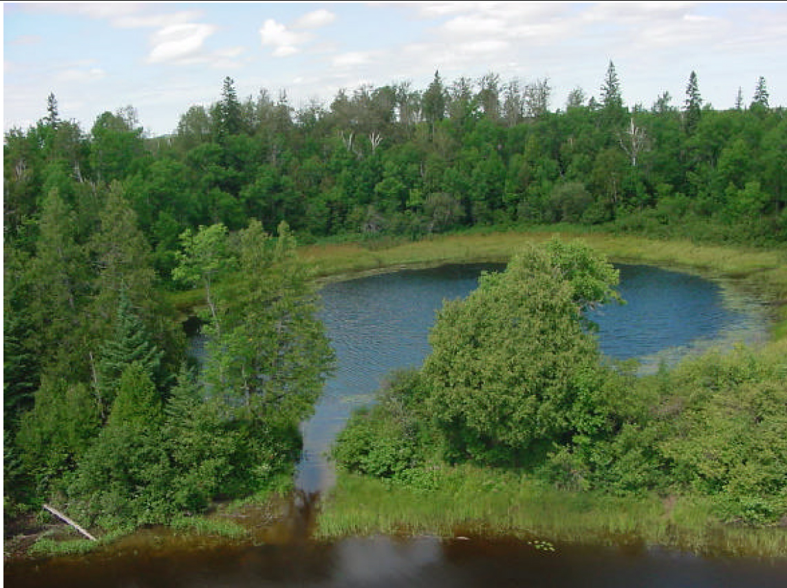
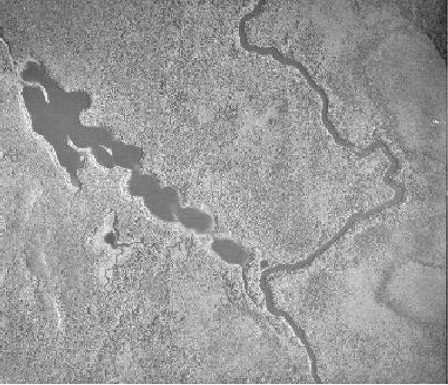
Figure 2.0 Small pond attached by a channel to the Montreal River (bottom of photo). This pond can also be seen on the aerial photograph (Figure 6.0). Photo taken by Craig Fuller August 18, 2001.
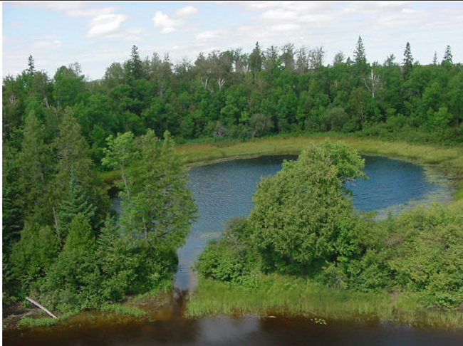
Enlarge Figure 2.0 Small pond attached by a channel to the Montreal River (bottom of photo).
5.0 State of the Resource
Representation:
Landform information provided by the Ontario Forest Research Institute (OFRI) (1994) showed that the majority of the site consists of weakly broken bedrock, however, aerial reconnaissance and photo interpretation by Kristjansson suggest a much different landform interpretation. The primary earth science features are contained within the extensive areas of ice-contact stratified drift deposits both unsubdivided and ice marginal deltas and within the large areas of organic deposits. The site also contains glaciolacustrine deposits. In addition, the site contains small deposits of both glaciolacustrine and ice-contact stratified drift (Map 1a). For more information on the Earth Science features see Big Spring Lake Earth Science Checksheet (Kristjansson 2002).
Riparian mixed woods of poplar, black spruce, white birch and black ash dominate the site. Cedar is located along the Montreal River, along with substantial black spruce forming pure stands or treed or semi-treed bogs3. Some isolated poplar, white birch and jack pine stands complete the vegetative features for the site. Finally, the forested ridge located just east of the site’s eastern boundary provides a natural lookout or observation area to view the treed bog and mixed woods to the west (Thompson 2001).
The wetlands within the site vary from; open water marshes4, treed bogs, semi-treed bog to treed bog, treed bog to black spruce. A large treed bog is situated along most of the eastern boundary and along part of the southern boundary. Another large semi-treed to treed bog is located in the middle of the conservation reserve (Map 3b).
The OFRI (1994) landform data classifies the majority of the site as lacustrine deposits. However, that does not correspond to the known earth science values observed within the conservation reserve. Refinement of the landforms based on the aerial reconnaissance survey and the surficial landform interpretation by Kristjansson (2001), now describes this site as organic deposits and ice-contact stratified deposits. One area contains glaciolacustrine deposits where poplar was observed during the aerial reconnaissance survey in 2001.
An arial reconnaissance survey conducted in 2001 and the aerial photo interpretation provided by Kristjansson, showed the site to have 3 major landform types with organic deposits and ice-contact stratified drift dominating the site. Using Kristjansson’s interpretation, the best available FRI (Forest Resource Inventory) data and the notes completed in the field by Thompson (2001), a minimum of 26 landform: vegetation combinations were noted (Appendix A – Life Science Checksheet) within this Conservation Reserve.
Quality of Representation:
The quality of the representation for the current characteristics of the natural features found within the conservation reserve are as important as the overall representative features that are being protected. A number of factors are considered in evaluating a site and they include the following criteria; diversity, condition, ecological factors, special features and current land use activities.
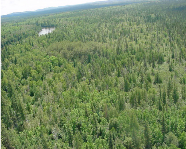
Figure 3.0 View looking north, east of the Montreal River. This picture shows the transition (from left to right) from a black ash mixedwood forest to a black spruce bog area. Photo taken August 18, 2001 by Craig Fuller.
 /p>
/p>
Enlarge Figure 3.0 View looking north, east of the Montreal River.
a) Diversity:
Diversity is a measure of the site’s life and earth science heterogeneity. The evaluation is based on the number and range (variety) of the natural landscape features and landforms for earth science values and the values and the relative richness and evenness of the site’s life science components. There are 3 major landforms of earth science features present within the site including ice-contact stratified drift, glaciolacustrine deposits and organic deposits (Map 1a). Life science diversity contains a minimum of 26 landforms: vegetation combinations (Appendix A). Thus, richness as defined by the number of cover types is high for such a small site. The proportion of cover type is somewhat skewed towards the black spruce and treed bog communities (Map 2a). However, most forest stands observed during the aerial survey in 2001 contained a wide assemblage of species. Wetland and aquatic values add to the site’s diversity but are not considered significant. Overall, the number of communities present within a small site and the large percentage of mature forest all contribute to the site’s high life science diversity rating. By protecting the full diversity of landforms in the conservation reserve, a greater diversity of vegetation types and plant and animal species is to be expected. The faunal diversity of the site is likely normal for the boreal region. However, a more definitive assessment of both floral and faunal diversity was not available based on the reconnaissance survey. A full biological inventory and evaluation would provide a more complex species list.
b) Condition:
Condition is the degree of past human and natural disturbances observed or recorded for the site. Disturbance is ranked low to moderate for this site. Disturbance within the Conservation Reserve is low; however, there has been cutting around the conservation reserve. The Conservation Reserve has some recreational potential. Two camps were seen during the aerial reconnaissance survey north of the reserve along the Montreal River and two trapper’s cabins are present on the southeast corner of Big Spring Lake and another on the Montreal River (Map3a).
c) Ecological Factors:
The overall design of the conservation reserve is average, since the site contains several vectored boundaries with many of the landforms and forest communities extending beyond the site’s borders. Boundaries are relatively good buffers. The eastern boundary although vectored follows the edge of a beautiful ridge. The southern boundary is vectored along the township line. Most of the western and part of the northern boundary follow the edge of Big Spring Lake and the Montreal River respectively. In addition, the remainders of the western and northern boundaries are vectored. Access to the interior will continue to make management and protection of the core areas problematic. The site’s poor design leaves many of the core forest communities and earth science features poorly protected. In the near future ground reconnaissance should confirm current level of disturbance especially in the large clear-cut areas surrounding the site. The site is considered not to be sensitive to existing uses. Additional protection of the conservation reserve’s values may be achieved outside of the site, during larger management planning exercises (FMPs).
d) Special Features:
There are several interesting features that make this site an excellent candidate as an addition to the protected areas system. The treed bog and semi-treed bogs, the stocking level of all the forest types observed, the lack of disturbance by man and the interesting black ash forest community are special features that enhance the site’s life science diversity. Also, the Montreal River provides fishing opportunities within the reserve. In addition, several mature forest communities are found throughout the protected area.
e) Current Land Use Activities
Only a small number of current uses are known to be associated with this site. Activities include trapping, hunting, canoeing, fishing, camping and snowmobiling. Some trail and forest industry access is associated with the disturbed area in the northwestern portion of the Big Spring Lake Bedrock Conservation Reserve.
Summary:
Big Spring Lake Bedrock Conservation Reserve was listed in the OLL Strategy as protecting a dominant landform vegetation type represented by weakly broken bedrock with mixed deciduous forests. Other vegetation types include sparse forest, mixed coniferous forests, and dense deciduous forests. However, the forests are better described as predominantly coniferous forest communities on organic deposits with a few small pockets of mixed woods on ice-contact stratified drift and glaciolacustrine deposits. The site’s representation will have to be re-evaluated in context with the known landform values to determine the site’s level of significance.
In summary, a total of 5 separate forest communities were identified (Map 2a) with mature black spruce (potentially old growth) present in the treed bog areas of the site (Map 5). Black spruce and black ash communities dominate the site with poplar, white birch and jack pine complementing the other forest communities. Finally, old growth, wetlands and the beautiful lakeshore further enhance the site’s natural heritage values and diversity.
Natural Heritage Representative Features
This site contains extensive areas of ice-contact stratified drift deposits both unsubdivided and ice marginal deltas, as well as organic deposits and glaciolacustrine deposits. Also associated with this site are small deposits of glaciolacustrine and ice-contact stratified drift (Kristjansson 2002).
Following is a chart which indicates these different features and the species of trees which they support.
| C1617 Big Spring Lake Bedrock Conservation Reserve | Black Ash, Poplar, White Spruce, White Birch | White Birch, Poplar, White Spruce | Poplar, Jack Pine, White Birch, White Spruce | Poplar, Black Spruce, Black Ash | Poplar, White Spruce, Black Ash, White Birch | Poplar, Black Ash, Larch, Cedar | Poplar, White Spruce, Black Spruce, Jack Pine | Black Spruce | Black Spruce, Larch, Cedar, Black Ash | Black Spruce, Cedar, Larch | Black Spruce, Larch | Black Spruce, Larch, White Spruce | Black Spruce, Black Ash |
|---|---|---|---|---|---|---|---|---|---|---|---|---|---|
| Ecosite | 7f1 | 7f | 7m | 10 | 10 | 13r | 6m | 11 | 13r | 13r | 14 | 13r | 13r |
| Organic Deposits | Mature2 | N/A | N/A | N/A | Mature | N/A | N/A | Old Growth | Mature | N/A | Mature | Old Growth | Old Growth |
| Glaciolacustrine Deposits – unsubdivided | Mature | N/A | Mature | N/A | Mature | Mature | Mature | N/A | N/A | Mature | N/A | N/A | N/A |
| Ice-Contact Stratified Drift Deposits – unsubdivided | Mature | Mature | N/A | Mature | N/A | N/A | N/A | N/A | N/A | N/A | N/A | N/A | N/A |
| Ice-Contact Stratified Drift Deposits – ice marginal delta | N/A | N/A | N/A | N/A | N/A | N/A | N/A | N/A | N/A | N/A | N/A | N/A | N/A |
| Bedrock-Drift Complex – drift cover discontinuous | N/A | N/A | N/A | N/A | N/A | N/A | N/A | N/A | N/A | N/A | N/A | N/A | N/A |
Refer to Appendix #7
Note: Landform: vegetation combinations have been grouped according to similar ecosite, landforms, age and species composition classifications.
Forest Resource Inventory (FRI) Data
- Dominant species, wetlands and depleted areas
- See Forest Stand Composition Map, Appendix 7
Values
- Deer habitat range
- Fish spawning area located just outside of the site
- 2 heron rookeries located to the west of Big Spring Lake
- 3 cottages (Big Spring Lake) and 1 base lodge (Montreal River) in close proximity to the site
- 2 trap cabins, one located on the east side of the Montreal River at the south end of the site and the other located on the southeast shore of Big Spring Lake.
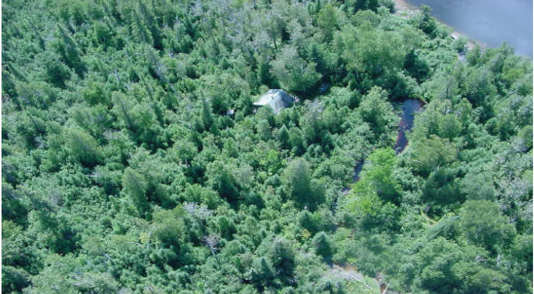
Figure 4.0 Photo of trap cabin located on the east side of the Montreal River. Photo taken August 18, 2001 by Craig Fuller.

Enlarge Figure 4.0 Photo of trap cabin located on the east side of the Montreal River.
5.1 Social/Economic Interest in Area
a) Linkage to Local Communities:
The Big Spring Lake Bedrock Conservation Reserve consists entirely of Crown land and is accessible by the Montreal River or the trails and logging roads in the area. There are no roads directly into the site, although there is a road off of Hwy. 65 which turns into a trail. This trail approaches the site from the north along the east side of the Montreal River and stops just north of the site at a private camp.
Current uses are related to consumption of fish and wildlife resources and snowmobiling.
Potential recreational activities could include riding, canoeing and possibly non-consumptive uses such as bird watching or nature study. In its present condition, the social and economic interest in the area is not likely to be expanded beyond the current uses.
b) Heritage Estate Contributions:
The Big Spring Lake Bedrock Conservation Reserve contributes to the province’s parks and protected areas system through its regulation, representation and the long-term management of its natural heritage values.
By allocating these lands to the parks and protected areas system through regulation, the province has ensured a certain level of permanence by distinguishing the site and its values from the larger general use or more extensively managed landscape. In addition, its natural features are, and will be available for present and future generations to enjoy and explore.
The site’s representation makes a minimal contribution to the province’s natural heritage estate. The glaciolacustrine wetlands and poplar mixedwood stands are considered provincially significant5. Additional analysis will have to be completed to see if the black spruce and wetland communities over organic soils and poplar mixedwoods over bedrock are provincially significant. The existence of any undisturbed landscapes contributes to the natural heritage estate values for this heavily developed Site District. However, the site’s small size, dense wetlands within the southern portions of the site and disturbed poplar mixedwood areas along the northern boundary mean that the site does not contribute significantly to current or potential recreational activities.
Long term management must consider public access to the site, the conservation reserve protection objectives, and commitments made in the OLL strategy (MNR 1999).
c) Aboriginal Groups:
The aboriginal communities in the Kirkland Lake District have not currently identified any traditional use areas or areas of interest within the site. However, the site is situated within the Temagami First Nation land claim area. Should any aboriginal values be located within the site, they will be protected accordingly.
d) Mining Interests:
There are no known current mining interests related to the conservation reserve. Mining and surface rights have been withdrawn from staking within the conservation reserve’s boundaries under the Mining Act (RSO 1990 Chapter M.14).
e) Forest and Fire Management History:
The site itself has not been affected by any recent forest management activities. However a recently harvested area is located bordering the western boundary of the site. Within the current Forest Management Plan for the Timiskaming Forest there is another harvest block located south of Big Spring Lake. These two harvest blocks and the associated roads will increase the access to this area.
The site has no recently burned areas within its boundary.
5.2 Natural Heritage Stewardship
Preliminary analysis of the life science targets based on landform/vegetation combinations showed the site contained 10 such combinations. A recent aerial reconnaissance survey showed significant pre-harvest areas located throughout the northern portion of the site. In addition over 88% of the site was incorrectly coded for earth science features. A total of three earth science landform features exist within the site including organic deposits, glaciolacustrine deposits and bedrock features. No outwash deposits occur within the site. The number of landform/vegetation combinations, which includes known forest stands and wetlands, exceeds expectations as a result of the gap analysis. However, a number of vegetative communities gained were also severely impacted due to recent harvesting.
5.3 Fisheries and Wildlife
There have been no detailed wildlife studies with the exception of some values assessment for the site and surrounding area. The Fish and Wildlife Values identified are moose calving sites, deer habitat range and cold-water fish species streams. Fishing opportunities are limited due to the relative lack of watercourses and lakes.
Some of the habitats associated with wildlife are wetlands and black spruce and aspen stands. All of these habitats, including the sections that have been harvested, provide year round habitat for moose as well as other species. The shoreline fen and beaver meadow areas provide excellent forage and breeding/nesting areas for waterfowl. However, much of the thicket swamp areas of alder and willow that dominate most of the organic soils in the south are of limited value for waterfowl.
5.4 Cultural Heritage Stewardship
To date, a detailed assessment of cultural resources has not been carried out. Although portions of Big Spring Lake and the Montreal River are indicated as having a high potential for cultural heritage values a complete evaluation is not intended at this time. Should the need arise for a full assessment of the cultural heritage values, it will be completed and the information in this report updated.
5.5 Land Use/Existing Development
The conservation reserve rests on Crown land and is unencumbered by any land use permits, leases or mining claims. Mining and surface rights have been withdrawn from the reserve (MNDM G-Plan M-0282 December 12, 2001). There are no identified development or current structures located within the boundaries of the site besides the two trap cabins.
5.6 Commercial Use
Present commercial use activities include four traplines (KL-106, 107, 108 and KL – 91) (See Land Use Map, Appendix 7), three bear management areas (BMAs KL-40-15, 40-19 and KL-28-46).
5.7 Tourism/Recreation Use/Opportunities
Features associated with this site which could enhance the tourism and recreational potential include the Montreal River, Big Spring Lake, mixed forests and wetlands. The river and lake offer potential water travel and sport fishing opportunities. The range of forest conditions is of general interest but also serves to attract a diversity of wildlife to the varied habitats.
Activities associated with this site include fishing, both summer and winter, snowmobiling, boating, canoeing, hunting and trapping as well as the use of the recreational and hunt camps. Other potential activities could include the viewing of old growth spruce stands as well as the red pine stands located north of the lake. Nature studies and wildlife viewing are also potential activities.
The uses and opportunities are also increased due to the presence of the three camps on Big Spring Lake and the two hunt camps. Access to the area has also been increased due to the timber harvesting that has taken place west of the site. Access to the area can also be achieved by using the numerous trails in the area.
For a more detailed report and summary of current and potential recreational use, refer to the Recreational Inventory Check-sheet (see Appendix 3).
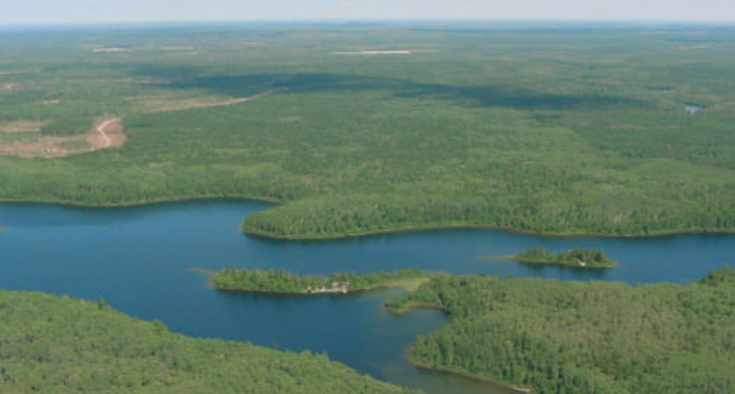
Figure 5.0 View of the site looking north over Big Spring Lake. In the photo you can see 2 of the camps on the lake as well as the start of the portage heading south in the bay at the bottom of the photo. Also shown is the harvest block to the west of the site and the road associated with it. Photo taken August 18, 2001 by Craig Fuller.

Enlarge Figure 5.0 View of the site looking north over Big Spring Lake.
5.8 Client Services
Currently visitor services are limited to responding to inquiries about access, natural heritage features and boundaries. No formal information or interpretive facilities currently exist within the conservation reserve.
Other client services include providing clients with maps, fact sheets and other information gathered on the area, such as the Earth/Life and Recreational inventory work.
6.0 Management Guidelines
6.1 Management Planning Strategies
The land use intent outlined in the OLL LUS (MNR, 1999) provides context and direction to land use, resource management, and operational planning activities on Crown land in the planning area and within OLL site boundaries. Commitments identified in the above strategy and current legislation (Policy 3.03.05 PLA) will form the basis for land use within Big Spring Lake Bedrock Conservation Reserve. Management strategies for these uses must consider the short and long-term objectives for the reserve. For up to date information on permitted uses refer to the Crown Land Use Atlas (MNR, 2002) (www.ontarioslivinglegacy.com/crownlanduseatlas/)(link no longer active).
New proposed uses and development will be reviewed on a case-by-case basis. A Test of Compatibility, (Procedural Guideline B – Land Uses PL 3.03.05) must be completed before proposal can be accepted. The emphasis will be on ensuring that the natural values of the conservation reserve are not negatively affected by current and future activities. Therefore any application for new specific uses will be carefully studied and reviewed.
6.2 "State of the Resource" Management Strategies
The future development of this SCI and the long term management and protection of the Big Spring Lake Bedrock Conservation Reserve will be under the direction of the MNR’s Kirkland Lake District, Kirkland Lake/Claybelt Area Supervisor. The following management strategies have been created to achieve the goal and objectives stated earlier in this management document.
Natural Heritage Stewardship
The management intent for the Big Spring Lake Bedrock Conservation Reserve is to allow for natural ecosystems, processes and features to operate undisturbed with minimal human interference while providing educational, research and recreational activities. Forest ecosystem renewal will only be entertained via a separate vegetation management plan. In addition the vegetation management plan will need to determine but not be limited to;
- the restoration ecology objectives (e.g. representation) for the area in context with the Site District;
- consider current provincial strategies (e.g. white pine);
- consider larger long-term conservation reserve (e.g. recreational objectives) and possibly landscape objectives (e.g. contributions to landscape wildlife objectives).
Forest fire protection will be carried out as on surrounding public lands, under the direction of the provincial fire strategy. All wildfire occurrences will be considered a high priority and will actively be suppressed. Prescribed burning will be conducted only under the direction of the provincial fire strategy and authorized for the conservation reserve under a separate vegetative management plan. Prescribed burning may be utilized if deemed necessary to emulate natural disturbances and renew forest communities, prepare seed beds for research and/or education purposes or to meet additional objectives determined within a separate vegetation management plan.
Defining compatible uses, enforcing regulations and monitoring and mitigating issues will serve to protect all earth and life science features. Industrial activities such as; commercial timber harvest and new hydro developments will not be permitted within the conservation reserve. Permits for fuel-wood will not be issued. Energy transmission, communication and transportation corridors or construction of facilities are not permitted within the boundaries of the conservation reserve. Such structures negatively impact on the quality of the representative features that require protection. Alternatives should be reviewed via larger landscape planning processes. New roads for resource extraction will not be permitted. Other activities that do not pass a Test of Compatibility will be prohibited (MNR Policy 3.03.05, 1997).
The introduction of exotic and/or invasive species will not be permitted. Programs may be developed to control forest insects and diseases where there is a concern that significant values may be compromised. Remedies must focus on the outbreak or infestation. Biological or non- intrusive solutions should be applied whenever possible.
The collection/removal of vegetation and parts thereof will not be permitted; however, subject to a Test of Compatibility, the Area Supervisor may authorize such activities for purposes of rehabilitating degraded sites within the reserve, collecting seeds for maintaining genetic stock and/or for inventory or research purposes.
MNR will provide leadership and direction for maintaining the integrity of this site as a heritage estate. To ensure MNR protection objectives are fully met within the conservation reserve, activities on the surrounding landscape should consider the site’s objectives and heritage values. Research, education and interpretation will be encouraged to provide a better understanding of the management and protection of the natural heritage values and will be fostered through local and regional natural heritage programs, initiatives and partnerships.
The conservation reserve will be managed by allowing natural ecosystems, processes, and features to function normally, with minimal human interference.
Programs may be developed to control forest insects and diseases in the conservation reserve where these threaten significant heritage, aesthetic, or economic values. Where control is desirable, it will be directed as narrowly as possible to the specific insect or disease. Biological control will be used wherever possible.
Fisheries and Wildlife
Fishery and wildlife resources will continue to be managed in accordance with specific policies and regulations defined by the Ontario Ministry of Natural Resources under the Fish and Wildlife Conservation Act and the Kirkland Lake District, Kirkland Lake/Claybelt Area Supervisor.
Fishing and hunting is expected continue at a low level of intensity. Wildlife viewing activities may be enhanced by a planned trail and the development of a viewing area. Any future trail development will require a test of compatibility.
Cultural Heritage
When possible, the Ministry of Natural Resources will continue to work with the Ontario Ministry of Culture, Tourism and Recreation in identifying archaeological sites to be protected. To more fully manage and protect sites, the development of field surveys would be required. However at this time additional field surveys within the Conservation Reserve are not recommended.
Development, research and education proposals may be considered in accordance with the Test of Compatibility; Conserving a Future for our Past: Archaeology, Land Use Planning & Development in Ontario, Section 3 (MCzCR, 1997).
Social/Economic
Forest fire protection will be carried out as on surrounding public lands, until alternative direction for the control of fire, or the use of fire for management purposes, is approved through a more detailed local natural resource plan or management plan.
Land Use and Development
The sale of lands within the conservation reserve is not permitted as per the OLL LUS (MNR, 1999). Existing authorized trails can continue unless there are significant demonstrated conflicts. New trails will only be allowed if a Test of Compatibility is passed. The cutting of trees for non- commercial purposes (e.g. fuelwood) is not permitted except as required for approved development activity (e.g. trail, viewing site, etc.).
New roads for resource extraction will not be permitted. Abandoned forest extraction roads will not be actively maintained.
Commercial Use
All existing commercial bait fishing and commercial bear hunting (within BMAs) operations are permitted to continue. Commercial bear hunting operations, for non-residents, are permitted and the transfer of existing licenses is allowed. No new commercial bear hunting operations will be permitted.
Existing commercial fur harvesting operations are permitted to continue. New operations may be considered subject to a Test of Compatibility. No new trap cabins will be permitted.
Aboriginal Interests
The Big Spring Lake Bedrock Conservation Reserve is within the Temagami First Nation land claim area. The District will comply with any input resulting from the final negotiated land claim. Aboriginal and treaty rights will continue to be respected.
Tourism/Recreation
The earth and life science features and their protection, shall be the overall theme for tourism. Small-scale infrastructures for enhancing tourism and recreation (i.e., warm-up shelter) may be considered, providing they pass a Test of Compatibility and other MNR requirements.
Most recreational activities that have traditionally been enjoyed in an area can continue provided they pose little or no threat to the natural ecosystems and features protected by the Conservation Reserve. These permitted activities include walking, hiking, wildlife viewing, fishing, hunting, snow shoeing, and cross-country skiing.
Snowmobiles and All Terrain Vehicles (s) are permitted on existing trails and forest access roads within the Conservation Reserve. Under the OLL LUS (MNR, 1999), all mechanized travel is restricted to existing trails. Off trail vehicle use is permitted for the retrieval of game only.
Existing trails for hiking, snowmobiling, use, cycling, horse riding and cross-country skiing can continue. To ensure the quality of the representation is maintained, all trails and old forest access roads within the site should be identified via new technologies (i.e. GPS) to ensure a record of these features exist. New trails can be considered through a Test of Compatibility.
Finally, conflict resolution between recreational uses will be a priority. This will be achieved by adhering to the objectives of this SCI with input from relevant user groups. The level of safety and compatibility between activities will determine permitted uses (i.e., Test of Compatibility).
Client Services
Clients indicating their interest in the management, planning and future use of this Conservation Reserve will be put on a mailing list and notified of any future planning in the site.
Present client services such as supplying maps, fact sheets and other information will also continue. Information may be delivered from different sources, however, MNR will be the lead agency for responding to inquiries regarding access permitted and restricted activities, values and recreation opportunities. A management agreement may be pursued with an appropriate partner to share responsibilities for information services and the delivery of other aspects of this SCI in the future.
6.3 Specific Feature/Area/Zone Management Strategies
There are no specific management strategies for the maintenance/protection/enhancement of selected resources within the conservation reserve. Development of such strategies will require an amendment to the SCI.
6.4 Promote Inventory, Monitoring and Assessment Reporting (IMAR), and Research
Scientific research by qualified individuals, which contributes to the knowledge of natural and cultural history and to environmental and recreational management, will be encouraged.
Additional life science inventory or research is required at this time to refine values and features. Additional assessment and monitoring of the disturbed areas, including trail and old road locations, within the site should occur prior to any additional management direction being finalized in a vegetation management plan for the area.
Research related to the study of natural processes will be encouraged provided it does not harm the values of the reserve. The Kirkland Lake/Claybelt Area Supervisor may approve the removal of any natural or cultural specimen by qualified researchers. All materials removed remain the property of the Ministry of Natural Resources. All research programs will require the approval of the Ministry of Natural Resources and will be subject to Ministry policy and other legislation.
New research developments such as campsites, privies, trails or developed access points or activities will not be considered until a Test of Compatibility is conducted and proposal is approved by the Kirkland Lake/Claybelt Area Supervisor. The Test of Compatibility or environmental screening process could include a review of the demand for structures or activities and may require more detailed life or earth science or cultural information and possibly a more detailed management plan.
Approved research activities and facilities will be compatible with the site’s protection objective. Permanent plots or observation stations may be established to which researchers can return over time. Any site that is disturbed will be rehabilitated as closely as possible to its original state.
6.5 Implementation, and Plan Review Strategies
Big Spring Lake Bedrock Conservation Reserve Statement of Conservation Interest will be reviewed on an ongoing basis and as required.
Implementation of the SCI and management of the reserve are the responsibility of the Area Supervisor. Partnerships may be pursued to address management needs.
If changes in management direction are needed at any time, the significance of the changes will be evaluated. Minor changes that do not alter the overall protection objectives may be considered and approved by the District Manager without further public consultation and the plan will be amended accordingly. In assessing major changes, the need for a more detailed Resource Management Plan will first be considered. Where a management plan is not considered necessary or feasible, a major amendment to this SCI may be considered with public consultation. The Regional Director must approve major amendments.
6.6 Marketing Strategies
Big Spring Lake Bedrock Conservation Reserve will be marketed as a representative natural area having earth and life science values, as well as certain recreational values. Marketing efforts to increase use are not a priority and will be kept to a minimum.
6.7 Boundary Identification
There is no stated policy requirement to mark the boundaries of a Conservation Reserve. Local management discretion can be used to determine where boundary marking may be appropriate. In order for restrictions to be enforceable, signs must be placed in accordance with the Trespass to Property Act or subsection 28 (1) of the Public Lands Act to advise against any restricted recreational activities.
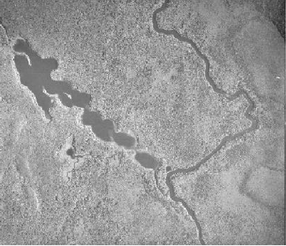
Figure 6.0 Aerial photograph taken during flights in 1996 by the Ministry of Natural Resources.
7.0 References
1983. Ontario Ministry of Natural Resources. Kirkland Lake District Land Use Guidelines.
1994. Ontario Ministry of Natural Resources. Ontario Wetland Evaluation System, Northern Manual
1990. Trespass to Property Act. Government of Ontario. Queen’s Printer. Toronto.
1992. Mining Act. Government of Ontario. Queen’s Printer. Toronto.
1993. Public Lands Act. Government of Ontario. Queen’s Printer. Toronto.
1997. Fish and Wildlife Conservation Act. Government of Ontario. Queen’s Printer. Toronto.
1997. Conservation Reserve Policy and Procedure PL 3.03.05. Ontario Ministry of Natural Resources. 30pp.
Ontario Ministry of Natural Resources, Ontario Living Legacy Land Use Strategy, July 1999
Saturday, 21st April, 2001. The Ontario Gazette, Volume 134-16. Queen’s Printer. Toronto
Bostock, H. S. Physiographic Subdivisions of Canada. Geology and Economic Minerals of Canada.
Harris, A. G., et. al. Field Guide to the Wetland Ecosystem Classification for Northwestern Ontario. Natural Resources Canada. May 1996.
Rowe, J. S. Forest Regions of Canada. Department of Fisheries and the Environment Canadian Forestry Service. 1972.
1Ecosite Equivalent based on Taylor et al, 2000 and OMNR 1999.
2Age Classes based on classification of ages by Geomatics International, 1997.
3Bog: are peat-covered areas or peat-filled depressions with a high water table and a surface carpet of mosses, chiefly Sphagnum. The water table is at or near the surface in the s pring, and slightly below during the remainder of the year. The mosses often form raised hummocks, separated by low, wet interstices. The bog surface is often raised, or, if flat or level with the surrounding wetlands, it is virtually isolated from mineral soil waters. Hence, the surface bog waters and peat are strongly acid and upper peat layers are extremely deficient in mineral nutrients. Peat is usually formed in situ under closed drainage and oxygen saturation is very low. Although bogs are usually cov ered with Sphagnum, sedges may grow on them. They may be treed or treeless but tree cover does not exceed 25%. A layer of ericaceous shrubs frequently characterizes bogs (MNR 1994).
4Marshes: are wet areas periodically inundated with standing or slowly moving water, and/or permanently inundated areas characterized by robust emergents, and to a lesser extent, anchored floating plants and submergents. Surface water levels may fluctuate seasonally, with declining levels exposing drawdown zones of matted vegetation or mud flats. Water remains within the rooting zone of plants during at least part of the growing season. The substratum usually consists of mineral or organic soils with a high mineral content, but in some marshes there may be as much as 2 m of peat accumulation. Waters are usually circumneutral to slightly alkaline and there is relatively high oxygen saturation. Marshes characteristically show zones or mosaics of vegetation, frequently interspersed with channels or pools of deep or shallow open water. They include open expanses of standing or flowing water which are variously called ponds, shallow lakes, oxbows, reaches or impoundments. Marshes may be bordered by peripheral bands of trees and shrubs but the predominant vegetation consists of a variety of emergent non -woody plants such as rushes, reeds, reed grasses, and sedges. Low shrubs such as sweetgale, red oiser, and winterberry may also occur. Where open water areas occur, a variety of submerged or floating plants flourish (MNR 1994).
5Provincially significant sites are areas defined by the gap analysis and that, taken together, provide the best representation of the array of landform and vegetation associations known to occur within the Site District 4E-5 (Crins and Kor 1997).