Bissett Creek Provincial Park Management Statement
This document provides direction on the management of Bissett Creek Provincial Park.
Interim Management Statement
Approval Statement
I am pleased to approve this Interim Management Statement for Bissett Creek Provincial Park. Ontario’s Living Legacy Land Use Strategy (1999) identified this area as a waterway class provincial park. This park was regulated under the Provincial Parks Act in June 2006 (O. Reg. 331/06).
This Interim Management Statement provides direction for the protection and management of Bissett Creek Provincial Park.
Signed by:
Paul Bewick
Zone Manager
Northeast Zone
Ontario Parks
Date: January 10, 2007
1.0 Introduction
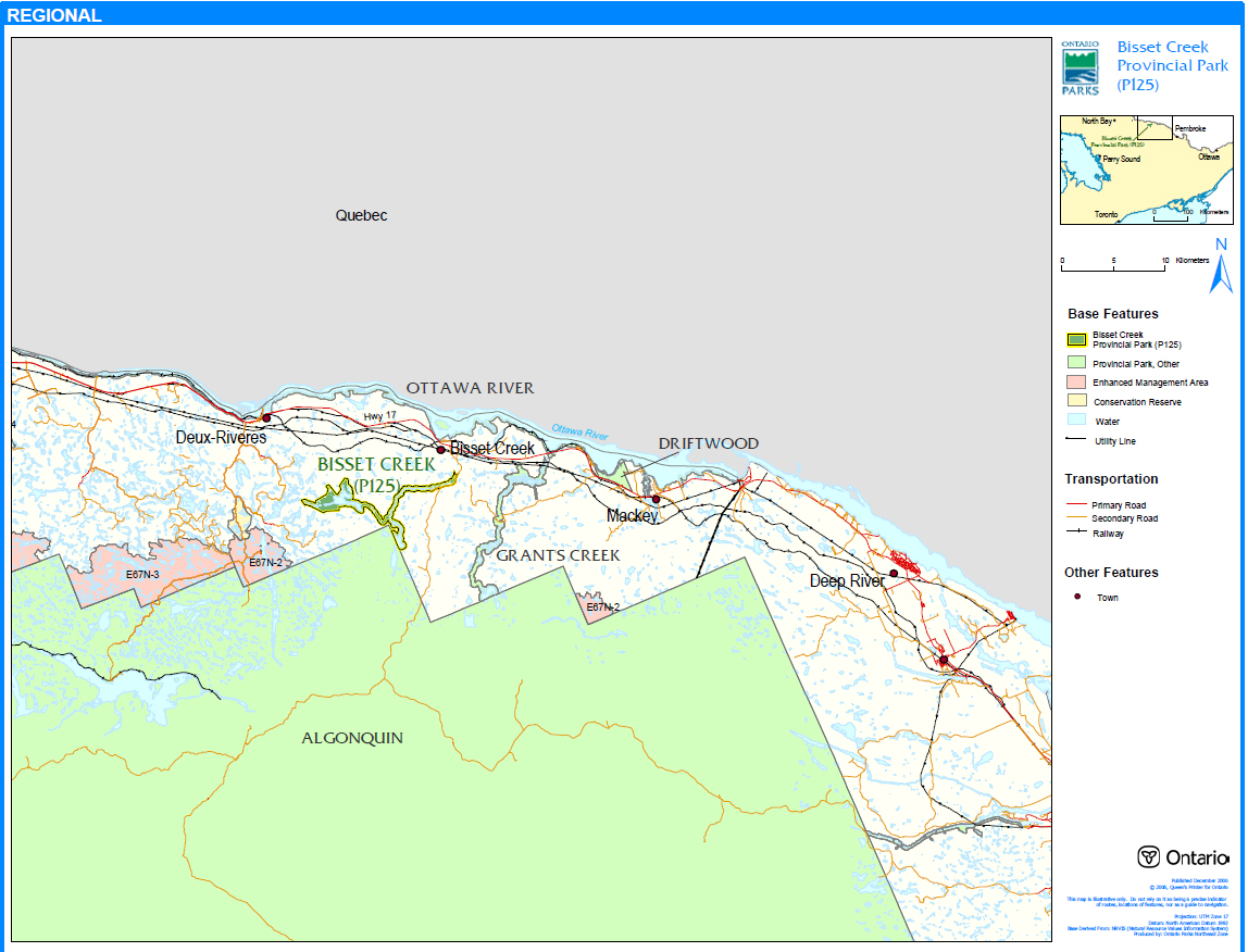
Bissett Creek Provincial Park (P125) is located approximately 10 kilometres southwest of the town of Bissett Creek, just north of Algonquin Provincial Park, in Ecodistrict 5E-10 (Figure 1). This 1,676 hectare park is located within the Townships of Clara and Maria (Figure 2). The park was established to protect the Waterloo Lake Uplands Area of Natural and Scientific Interest (ANSI) and to provide an ecological link between Algonquin Provincial Park and Upper Ottawa River Provincial Park.
Bissett Creek Provincial Park was regulated as a provincial park in June of 2006 (O. Reg. 331/06). This provincial park was identified through Ontario’s Living Legacy Land Use Strategy (OMNR 1999) and is classified as a waterway park. The purpose of the waterway designation is to protect outstanding recreational water routes and to provide high quality recreational and educational opportunities.
1.1 Objectives
Bissett Creek Provincial Park will be managed consistent with the four objectives for provincial parks:
Protection: To protect provincially significant elements of the natural and cultural landscapes of Ontario.
Recreation: To provide provincial park outdoor recreation opportunities ranging from high- intensity day-use to low-intensity wilderness experiences.
Heritage Appreciation: To provide opportunities for exploration and appreciation of the outdoor natural and cultural heritage of Ontario.
Tourism: To provide Ontario’s residents and out-of-province visitors with opportunities to discover and experience the distinctive regions of the Province.
2.0 Management Context
The purpose of this Interim Management Statement (IMS) is to provide direction to ensure the custodial management of park resources. Future park planning may be undertaken as required to provide direction on significant decisions regarding resource stewardship, development, operations and permitted uses.
Park management will follow direction from:
- Provincial Parks Act (1990) and regulations
- Ontario Provincial Parks Planning and Management Policies (OMNR 1992)
- Ontario’s Living Legacy Land Use Strategy and policy clarifications (OMNR 2000), amendments, and related direction
- Crown Land Use Policy Atlas (OMNR 2004a).
In addressing custodial management obligations to protect park values and ensure public health and safety, Ontario Parks will ensure that policy and Environmental Assessment Act (1990) requirements are implemented.
Figure 1: Regional Setting
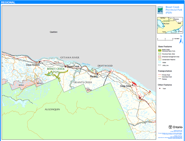
Enlarge Figure 1: Regional Setting
Figure 2: Park Boundary
Enlarge Figure 2: Park Boundary
2.1 Environmental Assessment
As a part of the Ontario Ministry of Natural Resources (MNR), Ontario Parks is a public sector agency which is subject to the Environmental Assessment Act. Park management will be carried out in accordance with legislation, policies, and guidelines that are required under A Class Environmental Assessment for Provincial Parks and Conservation Reserves (OMNR 2005).
3.0 Park Features and Values
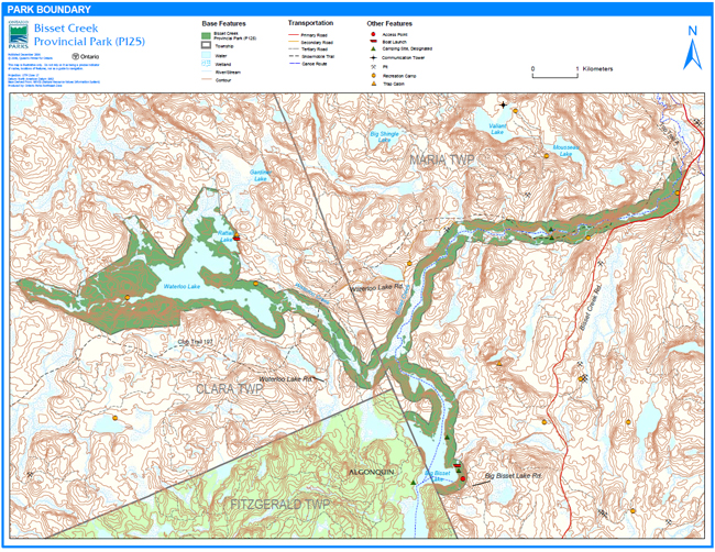
The park follows the natural watercourse of Bissett Creek from Big Bissett Lake, where it borders Algonquin Park, to the northeastern limit of the park south of the TOPS Trail A in Maria Township. Immediately to the north of Big Bissett Lake, the park also branches west, encompassing Waterloo Creek, Waterloo Lake, and Rattail Lake in Clara Township. The boundary is set back, on average, 200 metres from the water’s edge and includes the waters, creekbeds, lakebeds, and Crown islands of the described watercourse.
Bissett Creek Provincial Park is classified as a waterway class provincial park in recognition of the Waterloo Lake Uplands ANSI, and its protection of an ecological corridor and recreational water route between Waterloo Lake, Algonquin Provincial Park, and the Ottawa River. The park offers a variety of recreational opportunities, including fishing, hunting, and a backcountry canoe route between Algonquin Provincial Park and the Ottawa River. The park has a history of First Nations' occupation and commercial logging, which may provide the basis for future educational programming.
3.1 Geological Features
Bissett Creek Provincial Park straddles the Opeongo and Powassan Domains of the Algonquin Terrane, in the northeast region of the Central Gneiss Belt of the Proterozoic Grenville Province. Felsic and mafic gneisses of clastic metasedimentary and metaplutonic origin are the dominant rock types found within the park. Both the bedrock, which is represented by clastic sedimentary supracrustal and plutonic components of the Opeongo and Powassan Domains, and surficial geology of fossil plunge pools have regional significance within the Ontario Provincial Park system (Duba and Frey 2001).
3.2 Biological Features
The park protects the former Waterloo Lake Uplands ANSI, which has now been regulated as a provincial park. This waterway provides an ecological link between Algonquin Provincial Park and Upper Ottawa River Provincial Park. Bissett Creek Provincial Park encompasses two medium- sized lakes which drain into Bissett Creek, which in turn empties into the Ottawa River (Korol 2002).
Mature, pine-and spruce-dominated conifer forests, with a scattering of intolerant hardwood and mixed stands, flank the waterways of Bissett Creek Provincial Park. The park contains at least 266 species of vascular plants, 11 forest ecosite
3.3 Cultural Setting
An investigation into the cultural features specific to Bissett Creek Provincial Park has not been completed at this time; however, several potential cultural heritage sites and features were encountered during the 2001 field season and during the recreation inventory. The area’s cultural history spans from pre-historic to the 19th century (Marzinotto 2002).
Any future planning will be within the context of a provincial framework, A Topical Organization of Ontario History (OMNR 1974). In addition, updates and discussions with First Nations and other agencies and stakeholders may be carried out to identify cultural heritage values and features within the park and their significance. This information may be used to develop management guidelines to conserve and protect representative archaeological and historical values and features, or to provide direction for further research.
3.4 Recreation
The main recreational opportunities within the park include camping, canoeing, fishing, hunting, and snowmobile use. Some unauthorized all-terrain vehicle (ATV) use is also likely occurring within the park on existing tertiary access roads and/or trails. Low-impact recreational activities, including canoeing, swimming, hiking, and nature-appreciation will be permitted and encouraged in Bissett Creek Provincial Park.
A portion of the former Bissett Creek Canoe Route is located with the park. There are at least 10 portage trails are associated with the Bissett Creek Canoe Route which extends outside the boundaries of the park into adjacent lands. The route is currently not maintained but can still provide a challenging backcountry experience. The route is considered to be moderately difficult and should only be undertaken by those familiar with wilderness travel and camping (Marzinotto 2002).
Through future management planning, further management prescriptions may be made to minimize user conflicts and maximize user enjoyment. In the interim, any recreational activity that is found to have a negative impact on the features and values of Bissett Creek Provincial Park may be restricted or limited in order to minimize the negative effects.
4.0 Aboriginal Uses
Bissett Creek Provincial Park lies within the Williams Treaties of 1923. Bissett Creek Provincial Park lies within an area under Aboriginal land claim. The Claim by the Algonquin Nation of Ontario covers portions of lands in the Ottawa and Mattawa River watersheds. The Algonquin Nation and other Aboriginal communities will be consulted during future management planning.
First Nations have expressed interest in and have shared knowledge of the park and surrounding area. Aboriginal communities have used the area for hunting, trapping, fishing, gathering, and travel. These uses may continue, subject to public safety, conservation, and other considerations.
Any communications and cooperation between Aboriginal communities and the MNR for planning and operations purposes will be done without prejudice to any future discussions or negotiations between the government of Ontario and Aboriginal communities.
5.0 Stewardship Policies
The removal, damage or defacing of Crown properties, natural objects, relics, and artefacts is not permitted in provincial parks (Provincial Parks Act).
Non-native species will not be deliberately introduced into the park. Where non-native species are already established and threaten park values (i.e., has become invasive), a strategy to control the species may be developed (OMNR 1992).
5.1 Terrestrial Ecosystems
5.1.1 Vegetation
Harvesting
Commercial forest operations are not permitted within the park (OMNR 1992).
The harvest of non-timber forest products such as club moss, Canada yew, etc., will not be permitted within the park (OMNR 1992).
Existing authorized wild rice harvesting may continue. New operations will not be permitted.
There are no fuelwood cutting permits currently issued for the park. New permits will not be issued (OMNR 2000).
Insects and Disease
Insects and diseases may be managed where the aesthetic, cultural, or natural values of the park are threatened (OMNR 1992). Control measures will follow guidelines established by the Ontario Ministry of the Environment (MOE) and MNR. Whenever possible, biological control measures will be given preference over the use of chemicals (OMNR 1992).
Fire
Bissett Creek Provincial Park is located within the Great Lakes-St. Lawrence Fire Management Zone. In accordance with existing provincial park policy and the Forest Fire Management Strategy for Ontario, forest fire protection will be carried out in the park as on surrounding lands (OMNR 2004b). Whenever feasible, MNR's Forest Fire Management program will use techniques that minimize damage to the landscape, such as limiting the use of heavy equipment or limiting the number of trees felled during response efforts (OMNR 2004b).
5.1.2 Wildlife Management
Bissett Creek Provincial Park is located within Wildlife Management Unit 48. The removal or harassment of non-game animals is not permitted (Provincial Parks Act).
Hunting
Sport hunting is permitted to continue. Considerations of safety and conservation with respect to hunting may be made through future management planning, which would include public and Aboriginal consultation (OMNR 2000).
The Fish and Wildlife Conservation Act (1997) and the Migratory Birds Convention Act (1994) govern hunting within the park. The Ontario Hunting Regulations Summary contains regulations specific to this area. The harvest of bullfrogs or snapping turtles is illegal in provincial parks.
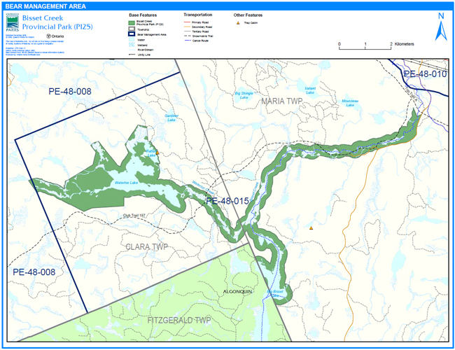
Bear Management Areas
Portions of two bear management areas (BMA) occur within the park: PE-48-008 and PE-48-015 (Figure 3).
Figure 3: Bear Management Area
Enlarge Figure 3: Bear Management Area
Existing commercial bear hunting operations are permitted to continue. This activity may be subject to conditions identified during future management planning (e.g., the designation of nature reserve zones). New BMA licences will not be permitted (OMNR 2000; 2003).
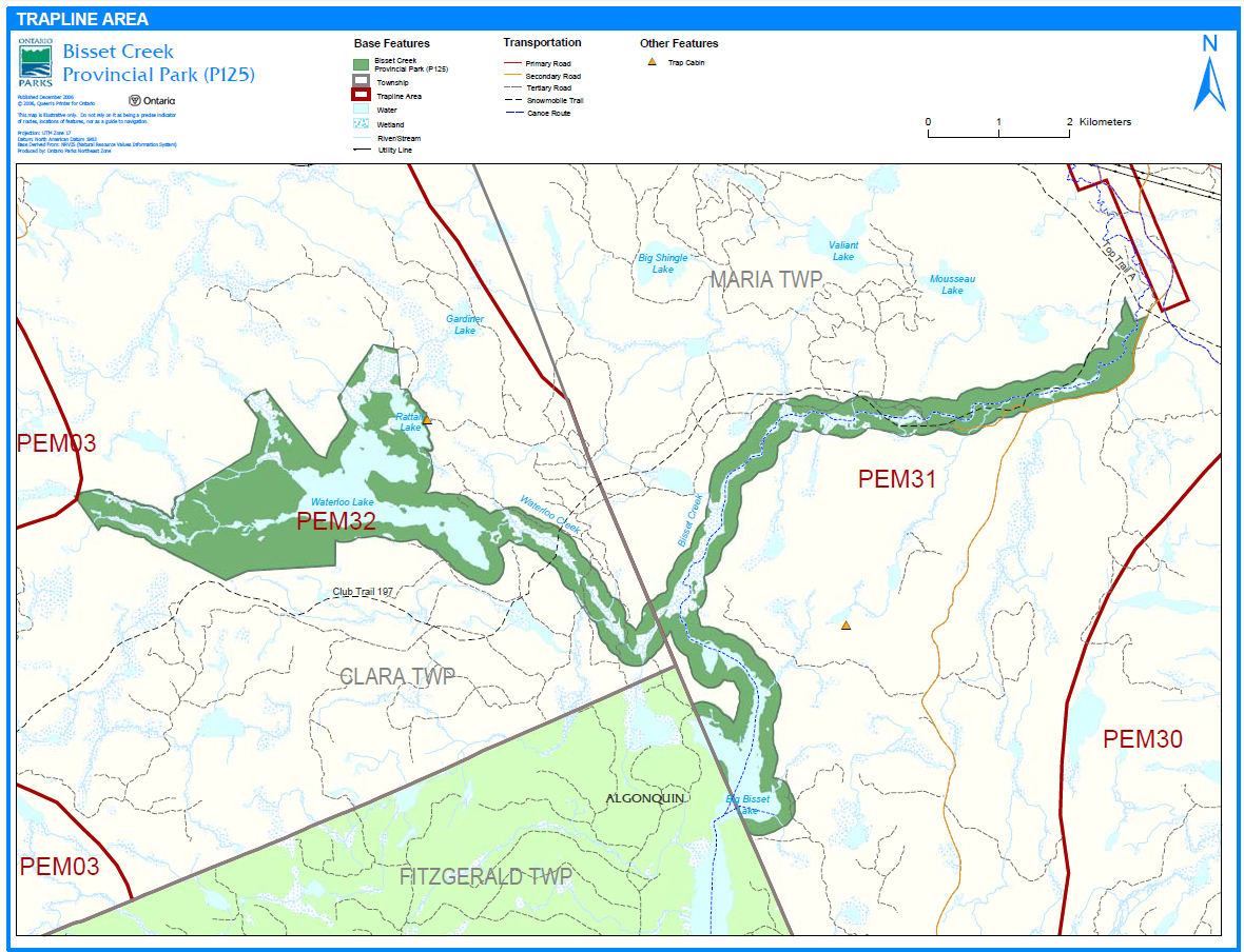
Trapping
There are portions of three licensed traplines included within the park: PEM03, PEM31, and PEM32 (Figure 4). There is one trap cabin located adjacent to the park near Rattail Lake.
Existing commercial fur harvesting operations may continue where the activity has been licensed or permitted since January 1, 1992. New operations, including trap cabins and trails, will not be permitted (OMNR 2000; 2003). Transfers of active trap line licenses are permitted, subject to a review of potential impacts and the normal transfer or renewal conditions that apply
5.1.3 Industrial Resources
There are no aggregate pits located within the boundary of Bissett Creek Provincial Park. Aggregate extraction is not permitted in provincial parks unless it is allowed by regulation (OMNR 1992; 2004a; Provincial Parks Act 1990). Mineral exploration and mining are not permitted in the park.
5.1.4 Access and Crossings
Access
The park is accessible by road, water, and air at various locations.
There is a designated access point and some parking avaliable on Big Bissett Lake. This access point can be accessed via a tertiary road locally known as Big Bissett Lake Road. A number of informal access points, parking areas and boat launches are found within the park along Bissett Creek, Waterloo Lake, Waterloo Creek and Rattail Lake.
Bissett Creek Road, a primary access road, forms part of the boundary of the park. Waterloo Lake Road, a secondary/tertiary access road, weaves through the park and crossing over two bridges located on Bissett Creek and Waterloo Creek respectively. Both roads and bridges provide access to the site.
There is one existing snowmobile trail that provides access to the site. The Ontario Federation of Snowmobile Clubs (OFSC) Club Trail 197 runs through the eastern portion of the site along Bissett Creek and also crosses Waterloo Creek in Clara Township.
A series of tertiary/forest access roads may provide access to the site by ATV or snowmobile.
The park may also be accessed by the former Bissett Creek Canoe Route, which is no longer maintained but still provides a backcountry canoeing opportunity (Marzinotto 2002).
Aircraft may be authorized to land within the park.
Figure 4: Trapline Area

Enlarge Figure 4: Trapline Area
Roads
The park can be access by Bissett Creek Road, a primary access road, which follows the southern boundary of the eastern portion of the park. This road is not included within the regulated boundary of the park.
Waterloo Lake Road, a secondary/tertiary access road, branches from Bissett Creek Road. This road weaves in and out of the park, crossing two bridges located on Bissett Creek and Waterloo Creek respectively. The two bridged water crossings were put in place by forest industry in order to access cut blocks outside the park. The use of these bridges will be permitted to continue unless this use threatens park values.
A tertiary road, known locally as Big Bissett Lake Road, also provides access to the park. This road branches from Bissett Creek Road and connects to the eastern portion of the Big Bissett Lake access point.
There are fairly extensive networks of old logging roads, and other trails located in Bissett Creek Provincial Park and the surrounding area. These roads may be used by snowmobiles and/or ATV users. The full extent to which some of these roads and trails bisect park boundaries, and how heavily they are used, is presently not well known.
Where existing forest and/or tertiary access roads and bridges are essential for continued access beyond the park for forest management, access to in-holdings (e.g., land use permits, etc.), or recreation purposes, and alternative road access does not exist, or road relocation is not feasible, existing roads and required bridges will continue to be available for access. Continued use will include maintenance and may include upgrades (OMNR 2004a). Ontario Parks is not responsible for the maintenance or upgrade of any roads and/or bridges within the park boundary.
Any proposed development, maintenance or upgrading of existing roads and bridges must meet all Environmental Assessment Act requirements.
Utility Corridors
All public utilities (e.g., gas pipelines, transmission lines, communications towers) must avoid park lands wherever possible. New utility corridor crossings may be necessary to maintain essential public services (OMNR 2004a).
Any future utilities proposed through the park, where park lands are unavoidable, will be reviewed on a case-by-case basis. Protection of park features and values will be a priority and all requirements of the Environmental Assessment Act will be met.
Recreational Trails
Canoe Routes: Bissett Creek Provincial Park encompasses part of the Bissett Creek Canoe Route. This canoe route was maintained in the 1970s and appeared on Algonquin Park maps until 1989. There are at least 10 portages associated with the Bissett Creek Canoe Route which extends outside the boundaries of the park to Highway 17. The route is currently not maintained but can still provide a challenging experience. The route is considered to be moderately difficult and given a lack of maintenance should only be undertaken by those familiar with wilderness travel and camping (Marzinotto 2002).
Hiking Trails: There are no designated hiking trails within Bissett Creek Provincial Park. New trails (e.g., hiking) may be developed if the need arises. Any proposed development within the park is subject to Environmental Assessment Act requirements.
ATV Trails: There are no authorized ATV trails within the park. However, there is some existing unauthorized ATV use on forest and tertiary access roads within the park. Existing use of these roads to access LUPs is permitted continue unless this use threatens park values. ATV use may be authorized on old forest access and tertiary roads; this use will be reviewed during future park management planning. Off-trail ATV use is not permitted (OMNR 2000).
Snowmobile trails: There is one OFSC snowmobile trail, Club Trail 197, within Bissett Creek Provincial Park. There may also be some unauthorized snowmobile use along existing tertiary access roads. Snowmobile use on existing routes for access to a private in-holding, to LUPs and recreational ice fishing may continue unless park values are threatened. Snowmobile use may be authorized on old forest access and tertiary roads. Off-trail snowmobile use is not permitted. New snowmobile trails may be considered though future park management planning (OMNR 2000).
5.1.5 Adjacent Land Management
Forestry
The land adjacent to the park is located within the Ottawa Valley Forest Management Unit (#780). The Ottawa Valley FMU is currently managed by Ottawa Valley Forest Incorporated. The current management plan is in effect until 2026. Operations are in effect until 2011 (OMNR 2006).
Provincial Parks
There is one provincial park abutting, and two others that are in close proximity to the park.
Algonquin Provincial Park: This park borders Bissett Creek Provincial Park at Big Bissett Lake and is Ontario’s first provincial park. The park, which encompasses 18 townships, was originally designated as a national park in 1893 and subsequently re-designated to a provincial park in 1913. Algonquin Provincial Park protects various natural and recreational features and also contains numerous historical and archaeological resources.
Upper Ottawa River Provincial Park: This portion of the Ottawa River extends south from Parkman Township to the Ontario Power Generation dam in Rolphton. The park contains numerous recreational and scenic values. Stands of white pine, a symbol of the areas rich logging history will be protected in this corridor.
Grants Creek Provincial Park: This park protects the Grant’s Creek Marsh, a provincially significant wetland. The park provides an ecological link to Algonquin Park and offers a variety of recreational opportunities including a portion of an Algonquin Park canoe route. The forest surrounding the creek is a mixed upland forest dominated by white and red pine and poplar. Located close to the Ottawa River, the creek winds through a number of trout lakes, small waterfalls, and a scenic waterslide.
Conservation Reserve
There is one conservation reserve located west of the park.
Greenbough Esker Conservation Reserve (C130): The Greenbough Esker is a large, intact earth science feature. This CR contains mature, undisturbed upland pine forests growing on an esker landform, as well peatlands which have developed in glacially-influenced areas of restricted drainage. The peatlands sustain unique vegetation types and uncommon to rare species (e.g., provincially rare White Fringed Orchid).
Enhanced Management Area
There is one enhanced management area (EMA) located west of the park.
Algonquin Provincial Park Headwaters – Pembroke Enhanced Management Area (E67n-2): This EMA was established in recognition of the Algonquin park headwaters. Land use activities and resource management practices such as forestry, road construction, aggregate extraction, mineral exploration, development, etc., must be conducted in a manner that protects the water quality of the watershed.
General Use Areas
The Multiple Natural Resource Use General Use Area (G396) surrounds the majority of the park. Another general use area is located west of the park.
Multiple Natural Resource Use General Use Area (G396): This 614,179 hectare general use area covers a large portion of Eastern Ontario. Resource management in this general use area is directed towards multiple use management.
Greenbough Esker ANSI General Use Area (G435): The Greenbough Esker is a large, intact earth and life science feature. The central and southern portions of this general use area contain mature, undisturbed upland pine forests growing on an esker landform. Peatlands supporting unique vegetation types and uncommon to rare plant species have developed in glacially- influenced areas of restricted drainage.
5.1.6 Land Disposition
Bissett Creek Provincial Park is located within the townships of Clara and Maria within the MNR District of Pembroke.
New land disposition for the private use of individuals or corporations will not be permitted (OMNR 1992; 2000).
Land Use Permits, Licenses of Occupation, and Unauthorized Occupations
There are three private recreation camp land use permits (LUPs) located within the boundary of Bissett Creek Provincial Park. Two LUPs are located in Clara Township and one LUP is in Maria Township.
Existing authorized LUPs may be eligible for enhanced tenure but not the purchase of land. Rcreational camp LUPs cannot be changed to commercial LUPs unless this is supported during a review as part of park management planning. Enhanced tenure is defined as a possible extension of the term of the LUP for up to 10 years or upgrade in tenure (i.e. LUP to lease) (OMNR 2000a).
Enhanced tenure for an LUP is not guaranteed. Requests for enhanced tenure or to transfer LUPs will be reviewed based upon the following criteria:
- Continued compliance with the conditions of the LUPs
- Current land disposition policies for LUPs
- Consistency with park objectives to sustain values – no effects on heritage values and/or conflict with other uses
- Consistency with Aboriginal land claim negotiations or protocol agreements
- All rents, taxes, fees, rates, or charges are paid and in good standing.
An extension in the term of tenure for an existing LUP does not convey a commitment to provide for a change in the type or the standard of existing access to the private recreation camp.
There are no licence of occupations within the park.
One unauthorized occupation occurs at the south end of Rattail Lake within the park boundary which will be assessed to determine management direction.
Patent Land
The park is completely surrounded by Crown land with the exception of one private lot abutting the eastern border of the park. Private land is not included within the park boundary and as such park policy does not apply to these areas.
Boat Caches
There are no authorized boat caches located within the park. Boats are not permitted to be left unattended in the park without written permission from the superintendent under the authority of the Provincial Parks Act.
5.2 Aquatic Ecosystems
Sustaining quality water resources is integral to the protection of park and adjacent land values. The MOE enforces applicable legislation and regulations for water quality.
5.2.1 Water Management
There is no hydro development, nor are there water control structures, or diversions within the park. The remnants of a historical dam are located near the conjoining of Bissett Creek and Big Bissett Lake.
New commercial hydroelectric developments will not be permitted in Bissett Creek Provincial Park (OMNR 2000).
Fisheries Management
The park supports mainly lake and brook trout, but splake have also been stocked in the past. Smallmouth and largemouth bass have also been introduced into some lake trout lakes; as a consequence, natural trout populations have declined (Marzinotto 2002). Fisheries management will complement the maintenance and enhancement of native, self-sustaining fish populations (OMNR 1992).
Sport Fishing
Sport fishing is permitted within the park. This activity is governed by legislation and regulations in the Fish and Wildlife Conservation Act and the Fisheries Act (1985). The Recreational Fishing Regulations Summary contains details on the applicable regulations for this area.
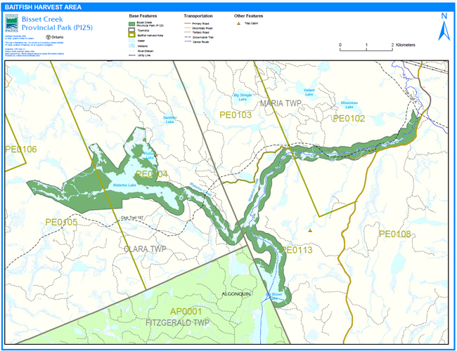
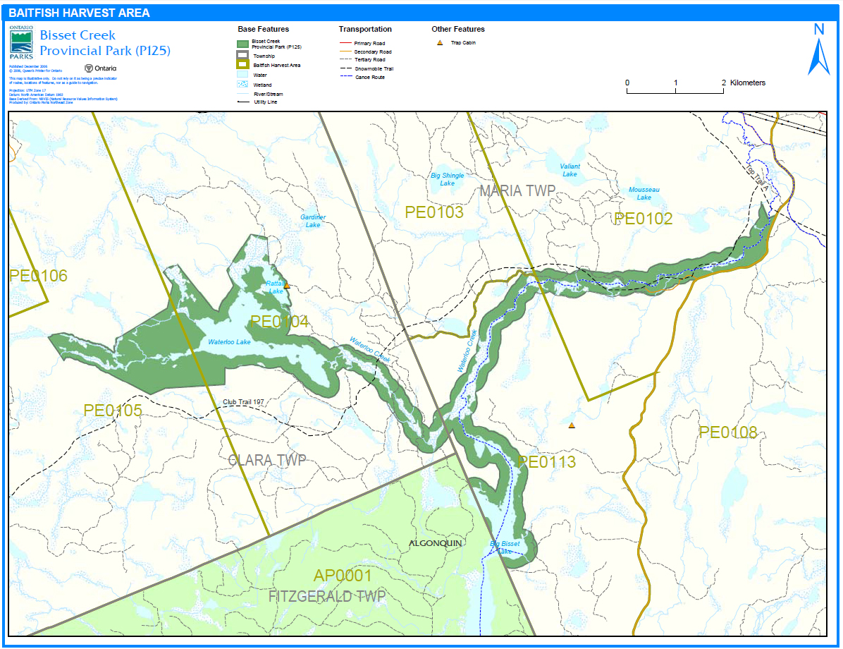
Commercial Baitfish Harvesting
There are portions of four baitfish harvesting license areas within Bissett Creek Provincial Park (Figure 5). Two licensed areas (PE0105 and PE0104) cover the western portion of the park in Clara Township, while two other license areas (PE0103 and PE0113) cover the eastern and southern portion of the park in Maria Township.
Existing commercial baitfish harvesting may continue where the activity has been licensed or permitted since January 1, 1992. This activity may be subject to conditions identified through future park management planning or fisheries management plans. New baitfish licenses will not be permitted (OMNR 2000; 2003).
Figure 5: Baitfish Harvest Area
Enlarge Figure 5: Baitfish Harvest Area
Fish Stocking
The stocking of native fish species may be considered through park management planning, with full public and Aboriginal consultation. Non-native fish species will not be deliberately introduced into park waters (OMNR 1992).
6.0 Operations Policies
6.1 Recreation Management
Future planning, with full public consultation, will review direction on motorized and non-motorized recreation uses.
6.1.1 Motorized Recreation
Motorboats
The use of motorboats is permitted to continue, unless park values are being threatened (OMNR 2004a).
Aircraft
Aircraft landings may be permitted within this waterway park (OMNR 2004a). All aircraft landings are subject to regulation and valid aircraft landing permits issued by the park superintendent under the authority of the Provincial Parks Act.
Snowmobiles
One authorized OFSC snowmobile trail, Club Trail 197, occurs within the park. This trail runs in a westerly direction through the eastern section of the park in Maria Township, as well as the midwestern section of the park in Clara Township. Snowmobile use on established routes for access to LUPs, and recreational ice fishing may continue unless park values are threatened. Snowmobile use may be authorized on old forest access and tertiary roads. Off-trail snowmobile use is not permitted within the park. Proposals for new snowmobile trails may be considered though future planning with public and Aboriginal consultation (OMNR 2000).
All-Terrain Vehicles
There are no authorized ATV trails within the park boundary. The existing use of forest and tertiary access roads to access LUPs is permitted continue unless this use threatens park values. ATV use may be permitted on old forest access and tertiary roads. Off-road use of all terrain vehicles will not be permitted within the park. Proposals for new trails may only be considered through future planning with public and Aboriginal consultation (OMNR 2000).
6.1.2 Non-Motorized Recreation
Camping
There are currently no managed campsites within Bissett Creek Provincial Park. There are four unmanaged campsites as well as areas that may support campsites (Marzinotto 2002).
Ontario Parks may assess the condition of existing campsites and will maintain, rehabilitate, or close sites as required. If there is an identified need, new campsites may be considered (OMNR 2004a). Infrastructure will be permitted in order to protect park features and values in response to use, environmental deterioration and environmental protection requirements. Any proposed development in the park must fulfill the requirements of the Environmental Assessment Act.
Hiking
There are no authorized hiking trails within the boundaries of this provincial park. If there is an identified need, the development of new hiking trails may be considered. Trail infrastructure to protect park values and features will be permitted. Any proposed development within the park is subject to Environmental Assessment Act requirements.
Canoeing/Kayaking
Existing uses may continue, unless park values are threatened (OMNR 2004a). Infrastructure to protect park features and values may be permitted and developed in response to use, environmental deterioration and environmental protection requirements.
6.1.3 Emerging Recreational Uses
There are emerging recreational uses for which there is limited or no policy to deal with their management (e.g., adventure racing and geocaching). The park superintendent will use legislation, policy, and guidelines which are in place to manage emerging uses in the interim.
6.2 Development
There are two existing boat launches located within the boundary this park; one boat launch is located on the east side of Rattail Lake and the other is on east side of Big Bissett Lake. The use of both of these boat launches will be permitted to continue unless this use threatens park values. Infrastructure to protect park features and values may be permitted and developed in response to use, environmental deterioration, and environmental protection requirements. Any proposed development within the park is subject to the Environmental Assessment Act.
6.3 Commercial Tourism
There are no existing tourism facilities located within the park. New commercial tourism facilities may be considered where they would be consistent with park policy (OMNR 2004a). Any development must meet the requirements of the Environmental Assessment Act.
7.0 Cultural Resources
First Nations' groups, who used the area for hunting and trapping, historically occupied portions of the Ottawa River Valley. Later, commercial timber harvesting operations developed in the region. The area was never heavily settled and remains sparsely populated.
Although a cultural heritage inventory has not yet been carried out for the Bissett Creek area, there is evidence of pre-contact to recent use. Upon completion of a cultural heritage inventory, management of any cultural values within this park will be directed toward protection and heritage appreciation (OMNR 1992).
8.0 Heritage Education
Literature and other supporting information may be developed to describe the park in the context of Ontario’s provincial park system. Boundary limits, significant heritage features and permitted uses of the may be included in park literature. Basic information on the park may also be provided through Ontario Parks' web site and on-site signage. One of the park’s valued characteristics is its relatively wild, remote and unspoiled setting. Actively promoting the park may adversely affect these qualities.
Prospective park visitors may be informed about the sensitivity and significance of park values through park literature.
9.0 Research
Scientific research by qualified individuals which contributes to the knowledge of natural or cultural history, or to environmental or recreational management, may be encouraged in the park. Ontario Parks will encourage institutions, such as universities, to undertake research projects.
All research programs will require the approval of Ontario Parks and are subject to park policy and other applicable legislation. Any materials removed from the park will remain the property of Ontario Parks.
Research dealing with all aspects of scientific study, inventory or surveys of flora, fauna, ecological, cultural, economic and recreational resources and processes will be encouraged. Subject to budgetary considerations, Ontario Parks may elect to conduct or solicit research on any of the above areas of interest.
Approved research activities and facilities will be compatible with the park’s protection objective. Any site which is affected by research will be rehabilitated as closely as possible to its original state. Environmental Assessment Act requirements will apply.
10.0 Implementation
In the implementation of this IMS, Ontario Parks may pursue opportunities for partnerships involving other agencies and groups. Park management and stewardship will be contingent upon availability of funding. All management and stewardship activities will conform to the Environmental Assessment Act and Provincial Parks Act.
11.0 References
Duba D. and E. Frey, 2001. Earth Science Inventory Checklist Bissett Creek Provincial Park P125. OMNR.
Environmental Assessment Act, 1990.
Fisheries Act, 1985.
Fish and Wildlife Conservation Act, 1997.
Korol, B.J., 2002. A Detailed Life Science Inventory of Bissett Creek Provincial Park, A report prepared for the Central Zone Office, Ontraio Parks, Huntsville, Final Report. OMNR.
Marzinotto, Erika, 2002. Bissett Creek Provincial Park (P125) Recreation Resource Inventory Report, Ontario Parks, Central Zone. OMNR
Mining Act, 1990.
Migratory Birds Convention Act, 1994
Ontario Ministry of Natural Resources (OMNR), 1974. A Topical Organization of Ontario History. Historic Sites Branch Division of Parks.
Ontario Ministry of Natural Resources (OMNR), 1992. Ontario Provincial Parks Planning and Management Policies, 1992 Update.
Ontario Ministry of Natural Resources (OMNR), 1999. Ontario’s Living Legacy Land Use Strategy.
Ontario Ministry of Natural Resources (OMNR), 2000. Ontario’s Living Legacy Land Use Strategy (Policy Clarification).
Ontario Ministry of Natural Resources (OMNR), 2003. Directions for Commercial Resource Use Activities in Provincial Parks and Conservation Reserves. 5 pp.
Ontario Ministry of Natural Resources (OMNR), 2004a. Crown Land Use Policy Atlas.
Ontario Ministry of Natural Resources (OMNR), 2004b. Forest Fire Management Strategy for Ontario.
Ontario Ministry of Natural Resources (OMNR), 2005. A Class Environmental Assessment for Provincial Parks and Conservation Reserves.
Ontario Ministry of Natural Resources, 2006. List of Forest Management Units (MU) in Ontario (2006/2007) (designated under the Crown Forest Sustainability Act, Section 7) All Management Units effective as of April 1, 2006. Accessed December 19, 2006. http://ontariosforests.mnr.gov.on.ca/spectrasites/Viewers/showArticle.cfm?id=C74F77D4-68C7-41A6-8D96FB6079073782&method=DISPLAYFULLNOBARNOTITLE_R&ObjectID=C74F77D4-68C7-41A6-8D96FB6079073782&lang=FR&lang=EN&lang=FR&lang=EN
Provincial Parks Act, 1990.
Taylor, K.C., R.W. Arnup, B.G. Merchant, W.J. Parton, and J. Nieppola, 2000. A Field Guide to Forest Ecosystems of Northeastern Ontario (2nd ed.). Queen’s Printer for Ontario.
Appendix A: Background Information
| Name | Bissett Creek Provincial Park (P125) |
|---|---|
| Classification | Waterway |
| Ecoregion/Ecodistrict | 5E-10 |
| OMNR Administrative Region/District | Northeast Region – North Bay District |
| Total Area (ha) | 1,676 |
| Regulation date and Number | June 2006 (O. Reg. 331/06) |
Representation
Earth Science
The dominant rock types exposed are felsic to mafic gneisses of both clastic metasedimentary and metaplutonic origin of the Powassan and Opeongo Domains, Algonquin Terrane, in the northeastern part of the Central Gneiss Belt of the Proterozoic Grenville Province.
The Grenville Province is the product of thrusting and imbrication of the crust to the northwest as it collided with a continental landmass southeast. The Grenville Orogeny, circa 1140 to 1070 million years ago, culminated more than 500 years ago of crustal evolution. The eroded roots of the products of these events are displayed in the complexly metamorphosed and deformed rocks of the region.
The Algonquin Terrane is on of four lithotectonic terranes of the Central Gneiss Belt. Within the Alogonquin Terrane, the Powassan and Opeongo Domains are two of twelve structural domains. These geological environments are part of the modern organization of the complex products of the mid-Proterozoic Grenville orogenic events. As such, their representations in the Bissett Creek Provincial Park contribute to the conservation of the Grenville continental accretion theme.
The representation of clastic sedimentary supracrustal and plutonic components of the Opeongo and Powassan Domains of the Algonquin Terrane and the surficial fossil plunge pools that were active during the postglacial drainage through the Ottawa Valley are considered to be regionally significant (Duba and Frey 2001).
Life Science
The park protects the former Waterloo Lake Uplands Area of Natural and Scientific Interest. This waterway provides an ecological link between Algonquin Provincial Park and the Upper Ottawa River Provincial Park. Bissett Creek Provincial Park encompasses two medium sized lakes that drain into Bissett Creek, which in turn empties into the Ottawa River (Korol 2002).
Mature, pine- and spruce-dominated conifer forests, with a scattering of intolerant hardwood and mixed stands flank the waterways of Bissett Creek Provincial Park. The park is home to at least 266 species of vascular plants, 11 forest ecosite types and 27 non-forested ecosystems. Most plant communities are in excellent condition. Various species were identified during the 2001 inventory including 11 herptiles, 80 birds and 14 mammals. Evidence of historic logging and fire in park boundaries appears to be limited and mature Eastern White and Red Pine remain abundant. No recent (i.e., less than 20 years old) evidence of fire or significant insect or tree disease outbreaks within park boundaries. Except for trails and water access points, most plant communities are in excellent condition with few (6% of the park’s flora) non-native plants (Korol 2002).
The park has a high perimeter to area ratio and its surrounding forests continue to be actively logged. As a result, the threat to the conservation of regional forest interior habitat is significant.
Forestry activities in the Bissett Creek watershed and in Algonquin Park may also be affecting water quality. Bissett Creek Provincial Park will help to protect most of the ecological link between Algonquin Provincial Park and the Ottawa River but adjacent land uses (i.e., logging and ATV use) limit its potential. Recent evidence of human disturbance (e.g., ATV use) has had localized but severe impacts on forest communities and soils. Veteran trees with the park, adjacent to logged areas on Crown and private land, are potentially threatened by wind throw (Korol 2002).
Cultural Resources
The area was never heavily settled and remains sparsely populated to this day. A cultural inventory of Bissett Creek may document features in the site. A cultural heritage values inventory should be carried out for proper documentation and conservation of areas of potential cultural heritage interest.
Although a cultural heritage inventory has not yet been carried out for the Bissett Creek area, there are potential cultural heritage sites and features that would benefit from an inventory.
Recreation
The main recreational opportunities within the park include camping, canoeing, fishing, hunting and snowmobile use. Some ATV use is also likely occurring within the park on existing tertiary access roads and/or trails. Low-impact recreational activities, including canoeing, swimming, hiking and general nature-appreciation will be permitted and encouraged in Bissett Creek Provincial Park (Marzinotto 2002).
A portion of the former Bissett Creek Canoe Route is located with the park. There are at least 10 portage trails are associated with the Bissett Creek Canoe Route which extends outside the boundaries of the park into adjacent lands. The route is currently not maintained but can still provide a challenging, rustic backcountry experience. The route is considered to be moderately difficult and should only be undertaken by those familiar with wilderness travel and camping (Marzinotto 2002).
Should funding permit, additional field visits to confirm the extent and intensity of recreational activities in the area could be carried out. Proper documentation of the exact condition and location of all relevant tertiary access roads and/or trails in and around the park could also be carried out. An evaluation of existing campsite use could be undertaken to determine if these campsites are overused and the extent of overuse (Marzinotto 2002).
Recommendations for the area include regular trail maintenance, new OMNR portage trail signs should be added or replaced where needed, deadfall and other obstructions could be removed from the trails should funding permit. A potential alternative or addition to the Bissett Creek canoe route would be to link the numerous portage trails along the Bissett Creek canoe route and create a hiking trail alongside the creek should funding permit. A number of the portage trails already provide scenic vistas of the creek and opportunities for a number of nature activities and wildlife viewing (Marzinotto 2002).
Inventories
| Survey Level | Earth Science | Life Science | Cultural | Recreational |
|---|---|---|---|---|
| Reconnaissance | Duba and Frey 2001 | Korol 2002 | Marzinotto 2002 |
Footnotes
- footnote[1] Back to paragraph Ecosites are mappable, management-oriented groupings of vegetation on specific ranges of soil conditions. Ecosites have relatively uniform parent material, soils, hydrology and vegetation structure, and composition (Taylor, Arnup, Merchant, Parton, and Nieppola 2000). types, and 27 non-forested ecosystems. Except for trails and water access points, most of the plant communities are in excellent condition (Korol 2002). Various animal species, including 11 herptiles, 80 birds, and 14 mammals, were also identified.
- footnote[2] Back to paragraph Transfers include situations where a license is surrendered with a request that it be immediately reissued to another individual or organization that is assuming an existing operation. Trap cabins are considered part of a trapline and would be transferred with the trapline for the purposes of trapping. If a trapline license is revoked or surrendered, all portions of the registered line within the park will be rescinded from the legal description of the trap line (OMNR 2003).