Black Creek Provincial Park Management Statement
This document provides direction on the management of Black Creek Provincial Park.
Interim Management Statement
February 1986
Regional Director’s Approval Statement
This Interim Management Statement will provide interim direction for the management of Black Creek Park Reserve until it is determined if the area should be placed under regulation as a Provincial Park.
I am pleased to approve this Interim Management Statement for Black Creek Park Reserve.
Signed by:
Regional Director
Southwestern Region
Background Information
| Name | Black Creek |
|---|---|
| Proposed Class | Natural Environment |
| M.N.R. District | Owen Sound |
| M.N.R. Region | Southwestern |
| Total Area (ha) | 285 |
| Land | 285 |
| Water | N/A |
| Site Region | 6E |
| Site District | 14 |
| Date in Regulation | N/A |
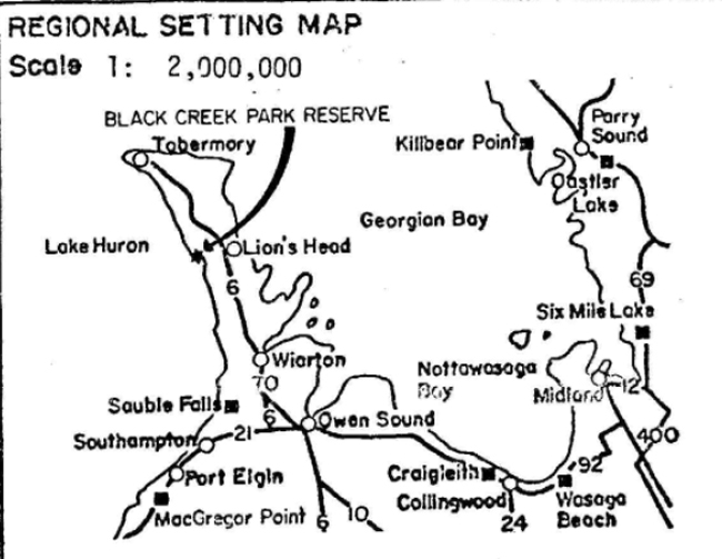
Map: Regional Setting

1. Life Science Representation
| Site Type/Landscape Unit | Species/Communities |
|---|---|
| Inland Rock Pavement/Wetlands | Beaver pond-wetland complex Mixed forest: white cedar, white birch, balsam fir, poplar spp. |
2. Earth Science Representation
| Geological Theme | Feature |
|---|---|
| Glacial Aeolin Lacustrine |
Striations, Roche moutonees Dunes Simple beach |
3. Cultural Resource Representation
| Theme | Theme Segment |
|---|---|
| Forest industries and Forest industry communities. Post contact tribes and bands. |
N/A |
4. Recreation Opportunities
| Day Use | Car Camping | Wilderness/Back Country |
|---|---|---|
| 6 picnic tables x 246 = 1506 | N/A | N/A |
Inventories
| Level/Type | Earth Science | Life Science | Cultural | Recreational | Other |
|---|---|---|---|---|---|
| Reconnaissance Completion Date | 1976 | 1976 | N/A | 1985 | N/A |
| Detailed Completion Date | 1982 | 1982 | Historical 1973 | N/A | N/A |
| Required? | N/A | N/A | Archaeological | N/A | N/A |
Date: February, 1986
A. Land Tenure
- The Crown presently owns a total of 286 hectares in the Black Creek Park Reserve (Figure 1).
- The Ministry of Natural Resources leases a 20 metre wide shore road allowance from the Township of Eastnor which includes a parking lot and sand beach.
- A land use permit is issued to the ‘Celtic Sports and Arts Centre for a dock.
Management Guidelines
-
The Owen Sound District Land Use Guidelines, 1983, indicate that Black Creek should be a natural environment provincial park. It was intended that the area represent the natural features of site district 6-14 as well as providing day-use and camping opportunities. However, the area has been examined with the result being that Black Creek lacks low cost, developable campground space and does not completely represent the site district.
Prior to the area being removed as a park reserve, site district 6-14 must be surveyed. The survey will determine if a better potential park area exists elsewhere or if the representation and recreation values are already located on Crown land.
- The Ministry of Natural Resources will continue to lease the shore road allowance on an annual basis until a decision is made on the status of the park reserve.
- The land use permit will continue to be issued on an annual basis until a decision is made on the status of the park reserve.
B. Existing And Proposed Development
The following is a list of facilities located in the park reserve:
- 2 vault toilets
- 2 entrance gates
- 2 change houses
- 9.4 km of trails
- 1 parking lot for 30 cars
- 1 foot bridge
- 4 garbage containers
- 1 dock
- 6 picnic tables
Figure 1: Park Boundary and Features
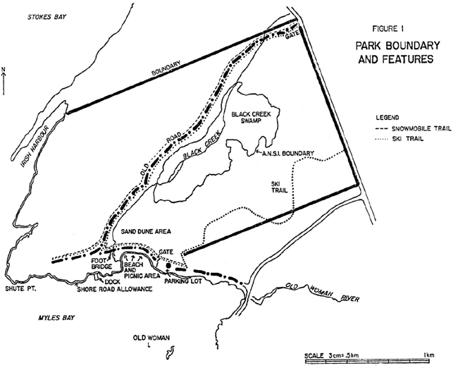
Enlarge Figure 1: Park Boundary and Features
Ducks Unlimited proposes to regulate Black Creek swamp through the construction of a water control structure on Black Creek where it leaves the swamp.
Management Guidelines
- Additional facilities are not being considered at this time.
- Maintenance is looked after by the Ministry of Natural Resources and will continue until the status of the park reserve is determined.
- The Ducks Unlimited proposal will not be acted upon until the status of the park reserve is determined.
C. Recreation Activities
The following recreational activities have been documented in the park reserve:
- swimming/skindiving
- fishing
- cross country skiing
- hunting
- boating
- hiking
- picnicking
- snowmobiling
Management Guidelines
The recreational activities will continue at their present level.
D. Commercial Activities
- Trapping - Trapping occurs in the park reserve.
- Bait Fishing - Bait fishing occurs at the mouth of Black Creek and in Lake Huron.
- Concessions - Periodically applications are made to establish concessions in the day-use area for the distribution of food items.
Management Guidelines
- Trapping will continue to focus on the prevention of flooding adjacent private lands while maintaining the beaver population.
- Bait fishing will continue
- Any concessions on the leased shore road allowance must be approved by the Eastnor Township Council before authorization will be considered by the Ministry of Natural Resources.
E. Natural Resources
- Life Science: A number of provincially rare plants are found in the park reserve. Winter deer areas have been found in the park reserve. A beaver pond complex is located near the centre of the property (Figure 1).
- Earth Science: A sand dune complex which is sensitive to any use or development is located directly behind the beach and picnic area (Figure 1).
Management Guideline
Activities which will negatively impact on these features will not be permitted.
F. Cultural Resources
- Pre-history: Two archaeological sites have been located in the park reserve.
- History: The Townsite of Hardwick was surveyed within the park area but was never developed. In the 1930’s cottage development began. The beach area was managed by the County of Bruce before the Ministry of Natural Resources took over the mid-l970’s.
Management Guideline
An archaeological survey is needed to locate additional sites and determine the significance of the two known sites.
G. Client Services
An interpretive program is not required at this time. The need for, and type of interpretive program will be determined once the status of the park reserve has been established.
H. Marketing
The beach is used intensively throughout the summer season. Due to the intensive use and limited capacity of the area, a marketing strategy is not required.
Appendix A and Bibliography
Appendix A: Provincially Rare Plants Found In Black Creek Park Reserve
Arabis lyrata var. lyrata (lyre leaf rock cress)
Circium pumilum ssphillii (Hill’s bull thistle)
Festuca occidentalis (western fescue)
Festuca rubra var. (red fescue)
Iris lacustris (dwarf lake iris)
Nuphar advena (raised bullhead lily)
Satureja glabella var. angustifolia (low calamint)
Senecio obovatus (obovate leaf ragwort)
Solidaga ohiensis (Ohio goldenrod)
Source: MacDonald, Ian; 1982
Bibliography
Cottrill, G. 1983. Property Management Plan for Black Creek Park Reserve, O.M.N.R., Ontario.
Cuddy, D., Norman, R. 1973. Ecological Inventory of the Black Creek Property. Bruce Peninsula, Ontario.
Folkes, P., 1973. Black Creek Provincial Park Historical Background.
Hoffman, D. W., Richards N. R., 1954. Soil Survey of Bruce County, Guelph, Ontario.
Jordan, R. W., 1969. Master Plan for Black Point Provincial Park, Lake Huron District, Ontario Department of Lands and Forests.
MacDonald, I., 1983. Life Science Inventory of Black Creek Provincial Park Reserve, O.M.N.R. Owen Sound.
Ontario Ministry of Natural Resources, 1983. Owen Sound District Land Use Guidelines, Owen Sound, Ontario.
1976. An Evaluation of Earth Science Features in the Parks, Park Reserves and Special Areas of Central and Southwestern Regions. Stokes Bay Park Reserve Earth Science Inventory Checklist.
Rungis, A., 1982. Owen Sound District Provincial Park Master Planning Status Report O.M.N.R. Owen Sound, Ontario.
Swayze, K., 1972. The Archaeological Survey of Cyprus Lake Provincial Park, Black Creek and Related Areas in the Bruce Peninsula, O.M.N.R.
Waldron, G., 1971. Ecological Survey of the Bruce Peninsula, International Biological Program and Ontario Department of Lands and Forests.